Verified Against Public And Audited RecordsLast Updated On: 2026-03-04
Reading time: ~51 min
File ID: EHGN-PLACE-35437
Investigative Bio of Bibury
Geographic Coordinates and Administrative Boundaries
Bibury is positioned at the precise geographic coordinates of 51. 7582° N latitude and 1. 8324° W longitude. In the British National Grid system, the village centre falls under the reference SP 115 066, while the primary visitor car park opposite the trout farm sits at SP 115 068. The civil parish covers an area of approximately 21. 03 square kilometres (2, 103 hectares), a figure that has remained relatively stable since the separation of Winson in the late 19th century. This territory encompasses the village of Bibury itself, the hamlet of Arlington on the western bank of the River Coln, and the settlement of Ablington to the north. The River Coln, a tributary of the Thames, acts as a central artery, physically bisecting the parish from northwest to southeast and historically defining the internal division between Bibury proper and Arlington.
The administrative history of this area from 1700 to the present reflects the broader evolution of English local government. In the 18th century, Bibury functioned as an ancient parish within the Hundred of Brightwells Barrow. This unit, a subdivision of the county of Gloucestershire, held judicial and fiscal responsibilities, including the maintenance of peace and the collection of taxes. During this period, the parish was a large, singular entity that included the chapelry of Winson. The governance structure relied heavily on the vestry system, where local landowners and clergy managed poor relief and highway repairs. The boundaries of the Hundred of Brightwells Barrow were ancient, likely predating the Norman Conquest, and served as the primary administrative above the parish until the 19th-century reforms began to the old system.
Significant shifts occurred in the 19th century with the introduction of the Poor Law Amendment Act of 1834. Bibury was incorporated into the Northleach Poor Law Union, shifting the focus of social welfare from the parish vestry to a centralized board of guardians. This change marked the beginning of the end for the Hundred as a functional administrative unit. By the late 1800s, the Local Government Act of 1894 established the modern civil parish system. It was during this era that Winson, previously a chapelry, was formally severed from Bibury to become its own distinct civil parish. This separation reduced Bibury's total acreage clarified the administrative responsibilities for the remaining settlements of Arlington and Ablington, which remained integral parts of the Bibury civil parish.
Administrative Evolution of Bibury (1700, 2026)
Time Period
Primary Administrative Unit
Higher Authority
Key Boundary Changes
1700, 1834
Ancient Parish
Hundred of Brightwells Barrow
Included Winson, Arlington, Ablington.
1834, 1894
Parish (Poor Law)
Northleach Union
Integration into sanitary districts.
1894, 1974
Civil Parish
Northleach Rural District
Separation of Winson into distinct parish.
1974, Present
Civil Parish
Cotswold District
Transfer to Cotswold District Council.
2024, 2026
Civil Parish
North Cotswolds Constituency
Parliamentary boundary redrawn.
The most administrative reorganization occurred with the Local Government Act 1972, which took effect on April 1, 1974. This legislation abolished the Northleach Rural District and merged it into the newly created Cotswold District. Bibury's governance moved to the district headquarters in Cirencester. The Act also solidified the three-tier structure of local government that to this day: the Bibury Parish Council at the most local level, the Cotswold District Council handling planning and waste, and the Gloucestershire County Council overseeing highways and education. The 1974 boundaries have proved durable, even with periodic reviews of electoral arrangements.
As of March 2026, Bibury falls within the Coln Valley ward for district council elections. This ward is a large rural grouping that includes surrounding parishes, reflecting the low population density of the area. The ward is represented by a single councillor on the Cotswold District Council. In January 2026, the representative was Councillor David Fowles. The parish council itself consists of seven elected members who serve four-year terms. The most recent full parish election occurred in May 2023, with the scheduled for May 2027. These councillors manage local assets, including the village green and the phone box in Ablington, and provide statutory consultation on planning applications.
A major change in parliamentary representation took effect prior to 2026. Following the 2023 Boundary Review, the constituency boundaries were redrawn for the 2024 General Election. Bibury, formerly part of "The Cotswolds" constituency, is situated within the "North Cotswolds" constituency. This change was part of a national effort to equalize the number of electors per MP. The new constituency covers a vast rural area, extending north towards Chipping Campden and Moreton-in-Marsh, while retaining the historic core of the Cotswold hills. This shift did not alter the local council boundaries changed the area's voice in Westminster.
The physical boundaries of the parish are defined by distinct topographical and man-made features. The northeastern edge follows the course of the River Leach for a short section, while the southern boundary runs along Akeman Street, a Roman road that connects Cirencester to Alchester. This straight alignment contrasts with the winding course of the River Coln, which does not serve as an external boundary rather as the internal spine of the community. The conservation area, in 1971, has its own specific boundary map that does not align perfectly with the civil parish. It encompasses the historic cores of Bibury and Arlington, including Arlington Row and Bibury Court, excludes the more modern agricultural buildings and outlying fields. This conservation boundary was subject to minor alterations in 1990 and 1998 to better protect the setting of listed buildings.
In late 2025 and early 2026, Cotswold District Council undertook a Community Governance Review. While nearby parishes like Southrop requested changes to their councillor numbers, Bibury Parish Council did not submit a request for major structural alteration. The review, concluding in March 2026, largely reaffirmed the existing governance arrangements for Bibury, confirming that the seven-councillor model remained appropriate for the parish's electorate size. Simultaneously, a "Devolution Local Plan Review" consultation ran until January 2, 2026, examining housing and strategic planning across the district. This process highlighted the tension between the fixed administrative boundaries and the fluid pressures of development, particularly regarding the protection of the National (formerly AONB) status that overlays the entire parish.
The relationship between the settlements of Bibury, Arlington, and Ablington remains a serious component of the administrative geography. While they share a single parish council, they maintain distinct identities. Arlington, frequently mistaken by visitors as part of a generic "Bibury," holds the majority of the residential population and the famous Arlington Row. Ablington, located a mile upstream, retains a separate hamlet character with its own manor and distinct history. The parish council officially represents all three, a unified governance structure that manages the shared resources and infrastructure, such as the footbridges over the Coln and the maintenance of the war memorial. This tripartite structure within a single boundary is a direct legacy of the ancient tything system that grouped these hamlets together centuries before the modern district council was formed.
Wool Industry Economics and Mill Operations (1700, 1900)
Geographic Coordinates and Administrative Boundaries
The visual serenity of Bibury in the twenty- century frequently obscures its origins as a site of intense, noisy, and pungent industrial labor. Between 1700 and 1900, the parish did not function as a passive agricultural backwater as a specialized node in the Gloucestershire wool trade. The economic engine of this period relied on a tripartite system: the water-powered processing at Arlington Mill, the high-density housing of the weavers in Arlington Row, and the drying grounds of Rack Isle. This infrastructure formed a localized factory system long before the centralized industrialization of the Victorian era.
Arlington Mill, recorded in the Domesday Book, underwent significant structural evolution to meet the demands of the 18th-century cloth market. While the current stone structure dates largely from the mid-17th century, its operations in the 1700s focused heavily on fulling. This process was essential for the production of broadcloth and kersey, the region's staple exports. Fulling involved cleansing the woven wool of natural oils (lanolin) and impurities, then thickening the fabric to create a dense, felted material. The mill used massive wooden hammers, known as stocks, driven by the rotation of the water wheel. These hammers pounded the cloth in vats filled with a mixture of water and fuller's earth, a clay-like substance capable of absorbing grease, and frequently stale urine, which served as a source of ammonia for bleaching and cleaning.
The sensory reality of 18th-century Bibury differed sharply from its modern presentation. The area around the mill would have smelled strongly of the ammonia used in the fulling vats. The rhythmic thud of the fulling stocks, audible throughout the valley, marked the passage of the working day. The River Coln provided the kinetic energy necessary for this operation. Engineers of the period channeled the river's flow to maximize the torque applied to the wheel, a need for lifting the heavy timber hammers. Historical records indicate the mill operated with dual functionality during the early part of this period, grinding corn for local subsistence while simultaneously processing cloth for the export market.
Directly adjacent to the mill lay the drying grounds, known today as Rack Isle. This marshy island, created by a mill leat diverting water from the main channel of the Coln, served a specific industrial purpose. After fulling, the wet, heavy cloth required stretching to prevent shrinkage and to square the weave. Workers stretched the fabric on wooden tentering frames, or "racks," anchored in the soft ground of the isle. The phrase "on tenterhooks" originates from the metal hooks used to secure the cloth during this drying phase. The preservation of Rack Isle by the National Trust protects a space that was once a crowded, functional yard, constantly trafficked by mill workers moving wet textiles from the vats to the frames.
The human component of this industry resided in Arlington Row. Constructed in 1380 as a monastic wool store for Osney Abbey, the stone structure underwent a radical conversion in the late 17th century. As the demand for cloth rose, the building was partitioned into a row of weavers' tenements. This conversion signaled a shift from storing raw materials to housing the labor force required to process them. The cottages were not spacious country homes; they were industrial dwellings. Weavers worked on handlooms, frequently located on the upper floors to maximize natural light, producing the "grey" (unfinished) cloth that would then be sent to the mill for fulling. The proximity of the housing to the mill and the drying racks created a highly, integrated production line within a radius of fewer than 200 meters.
Yet, the economic trajectory of Bibury's wool trade faced challenges as the 18th century progressed. The Industrial Revolution favored locations with access to coal and steeper water gradients capable of powering larger, more complex. The Stroud Valleys, to the west, possessed these geographic advantages and rapidly adopted steam power, centralizing production in massive multi-story mills. Bibury, absence rail access and coal deposits, could not compete with the speed and volume of the Stroud manufacturers. By the late 1700s, the cloth trade in Bibury had entered a terminal decline. The intricate network of weavers and fullers began to as the economic shifted toward the industrialized centers of Stroud and Yorkshire.
The 19th century marked a decisive transition for Arlington Mill. As the textile profitability, the facility pivoted entirely to corn milling. This shift reflected a broader national trend where rural watermills reverted to agricultural support roles. In 1859, the mill owners attempted to modernize by installing a steam engine to supplement the water wheel, ensuring consistent operation during summer droughts or winter freezes. This investment demonstrates that even in a declining industrial center, capital was deployed to maintain efficiency. The mill ground grain for flour and animal feed, serving the immediate needs of the parish's farms rather than international textile markets.
Table 1: Industrial Transition of Arlington Mill (1700, 1914)
Period
Primary Function
Power Source
Economic Focus
1700, 1780
Dual (Fulling & Corn)
Water Wheel
Textile Export & Local Subsistence
1780, 1850
Transitional (Declining Cloth)
Water Wheel
Shift to Agriculture
1859, 1914
Corn Milling
Water & Steam Engine
Local Agriculture & Feed
1914, Present
None ( Removed)
None
Tourism/Museum/Residential
Census data from 1851 provides a snapshot of this transformed community. By the mid-19th century, the occupation of "weaver" had largely disappeared from the parish records, replaced by "agricultural laborer," "shepherd," and "carter." The population of Bibury and Arlington became increasingly dependent on the fortunes of arable farming and livestock. The poverty associated with this period was acute. The picturesque stone cottages of Arlington Row, highly covetable real estate, were in the 1800s associated with damp, overcrowding, and subsistence living. The Sackville family, Lords of the Manor residing at Bibury Court, maintained ownership of the mill and much of the surrounding land, consolidating their control over the agrarian economy as the industrial one faded.
The final blow to the mill's industrial life arrived in 1914. The, obsolete and no longer economically viable against the massive roller mills of the port cities, was dismantled and removed. The building stood empty, its function as a processor of grain and wool extinguished. This demolition marked the end of over eight centuries of continuous industrial activity on the site. The steam engine, once a symbol of modernization, was scrapped, and the water wheel ceased to drive productive work.
In the context of 2026, the preservation of these sites by organizations such as the National Trust serves a dual purpose. While they protect the architectural integrity of the limestone structures, they also freeze a specific moment in time, post-industrial pre-modern. The absence of the noise, the smell, and the frenetic activity of the 18th century allows for a sanitized appreciation of the site. Yet, an examination of the physical evidence, the mill race, the tentering grounds of Rack Isle, and the cramped dimensions of the weavers' cottages, reveals the hard economic logic that shaped the village. Bibury was not designed as a scenic destination; it was built as a machine for processing wool, and its current form is the direct result of that industry's rise, stall, and eventual collapse.
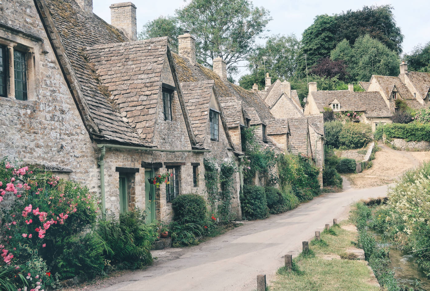
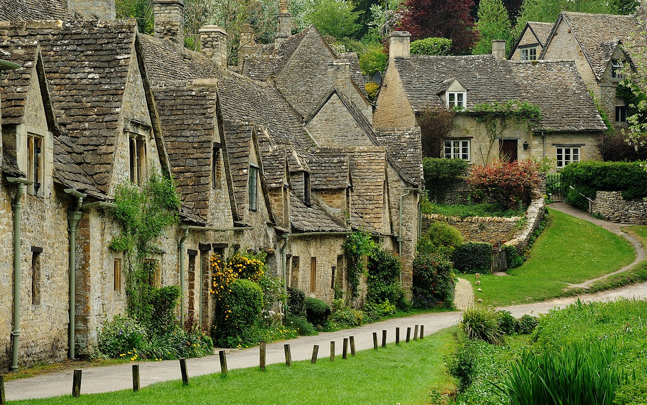
Arlington Row: Architectural Origins and National Trust Acquisition
The architectural genesis of Arlington Row lies in the late 14th century, specifically around 1380, when the structure rose as a monastic wool store for the Hospitallers of St. John. Yet its transformation into the iconic domestic dwellings seen today occurred later, bridging the late 17th and early 18th centuries. This conversion partitioned the long, low-slung stone building into a series of weavers' cottages to support the local cloth production trade. The limestone construction, sourced from local quarries, features a roof of heavy stone slates that diminishes in size from eaves to ridge, a technique required to manage the immense weight of the material. By the onset of the 1700s, these cottages functioned as a hive of industrial activity, with the adjacent Rack Isle serving as a drying ground where degreased wool hung on wooden timber frames.
Throughout the 18th and 19th centuries, the cottages housed laborers and weavers, their condition fluctuating with the fortunes of the wool trade. By the late 19th century, the aesthetic value of the row began to eclipse its industrial utility, catching the eye of the Arts and Crafts movement. William Morris, who famously declared Bibury "the most beautiful village in England," visited the area, cementing its status as a romanticized ideal of rural English life. Even with this recognition, the physical fabric of the cottages faced serious degradation by the early 20th century. The absence of modern amenities and the decay of the ancient stone roofing threatened the row's survival, prompting fears of demolition or irreversible ruin.
The intervention of the Royal Society of Arts (RSA) in 1928 marked a pivotal moment in the site's preservation history. In a direct response to the threat of modernization or neglect, the RSA purchased the row, backed by a fundraising campaign that generated approximately £1, 200. This acquisition was not a purchase a rescue operation. The Society conveyed the property to the Bristol and Gloucestershire Archaeological Trust, which executed immediate repairs in 1929. This pre-National Trust era of conservation focused on stabilizing the medieval timber cruck trusses, massive curved oak beams that had supported the roof since the 14th century, and ensuring the weathertightness of the stone slate roof.
In 1949, the National Trust acquired Arlington Row, securing its status as inalienable land. This designation prevents the property from being sold or mortgaged, guaranteeing its protection in perpetuity. The Trust undertook a detailed restoration program in the early 1970s, a project that revealed the full extent of the building's medieval origins. During this work, architects uncovered smoke-blackened trusses, proving the original hall had an open hearth long before the insertion of chimneys and upper floors. This restoration modernized the interiors for tenants while rigorously maintaining the exterior vernacular that defines the Cotswold aesthetic.
The tension between Arlington Row as a global tourist icon and a living community reached a flashpoint in January 2017. Peter Maddox, an 84-year-old resident, parked his bright yellow Vauxhall Corsa outside his cottage, a spot he had used for years. Tourists and photographers frequently complained that the modern, vibrant vehicle ruined their "perfect" period photographs. The dispute escalated when vandals scratched the word "MOVE" into the car's bonnet, smashed its windows, and caused £6, 000 in damage, resulting in the vehicle being written off. The incident sparked a national debate on the rights of residents versus the expectations of visitors. In a show of solidarity, a convoy of 100 yellow cars paraded through Bibury on April 1, 2017, defending Maddox's right to live normally within a heritage site.
Current management of Arlington Row balances these conflicting demands. As of 2026, the National Trust continues to lease the majority of the cottages to private tenants, with only number 9 as a holiday let to generate revenue for upkeep. The tenancy agreements are subject to strict preservation covenants, the legal is shifting. The Renters' Rights Act, which received Royal Assent in late 2025 and began full implementation in May 2026, introduced new protections for tenants in the private and heritage sectors. These changes abolished "no-fault" evictions, granting the residents of Arlington Row greater security of tenure even as the site faces intense pressure from over-tourism.
Maintenance of the Grade I listed structures requires a continuous influx of funds, primarily derived from National Trust membership and the holiday rental income. Recent conservation reports from 2024 indicate that the stone slate roofs require cyclical turning and replacement, a specialized skill that commands high costs due to the scarcity of qualified slaters. The Trust employs a "conservation in action" method, frequently allowing the public to witness repair works, thereby educating visitors on the expense and expertise required to maintain the 600-year-old fabric. The cottages remain a functional housing unit, not a museum, a distinction the Trust defends aggressively against calls to pedestrianize the lane entirely.
Arlington Row: Key Historical & Administrative Data (1700, 2026)
Era / Year
Event / Status
Key Details
Late 17th Century
Conversion
Transformation from monastic wool store to weavers' cottages.
1928, 1929
RSA Rescue
Royal Society of Arts purchases row; £1, 200 fund raised for repairs.
1949
National Trust
Transfer of ownership to National Trust; declared inalienable.
1970s
Major Restoration
Discovery of medieval smoke-blackened cruck trusses.
2017
"Yellow Car" Incident
Vandalism of resident's car; subsequent solidarity rally.
2026
Tenancy Reform
Implementation of Renters' Rights Act strengthens resident security.
Bibury Court: Jacobean Estate History and Ownership Transfers
Wool Industry Economics and Mill Operations (1700, 1900)
The ownership history of Bibury Court serves as a financial barometer for the English landed gentry, tracking the shift from hereditary accumulation to insolvency, and to modern high-net-worth acquisition. Built in 1633 by Sir Thomas Sackville on the site of a former Benedictine monastery, the Jacobean mansion anchors the village's architectural hierarchy. While the Sackville crest remains above the porch, the estate's survival depended on a series of capital injections following periods of mismanagement. The property passed through the female line of the Sackville family to the Cresswells in the 18th century. Estcourt Cresswell, who served as the Member of Parliament for Cirencester from 1768 to 1774, inherited the estate and initiated significant internal remodeling around 1759. These renovations introduced Georgian elements to the Jacobean structure, yet they also marked the beginning of a financial decline. Cresswell died in 1823, leaving behind a tangled web of debts and a disputed. The resulting litigation was so protracted and ruinous that local oral history frequently cites it as the inspiration for the case of *Jarndyce and Jarndyce* in Charles Dickens's *Bleak House*. The legal and financial paralysis ended only when the estate was liquidated to satisfy creditors. In 1829, Estcourt's son, Richard Estcourt Cresswell, sold the manor and its tithes to Lord Sherborne (John Dutton). This transfer marked the end of the Sackville-Cresswell lineage's direct control. For the remainder of the 19th century, Bibury Court ceased to be a primary seat of power and functioned instead as a secondary residence or rental property within the vast Sherborne land portfolio. The Dutton family maintained the structure did not prioritize it, leading to a gradual deterioration of the fabric by the early 20th century. A pivotal injection of capital occurred in the 1920s. Sir Orme Bigland Clarke, a barrister and former legal adviser to the Ottoman government, purchased the house and surrounding estate from Lord Sherborne in 1924. Clarke brought with him American wealth through his wife, Elfrida Roosevelt, a granddaughter of James Alfred Roosevelt. The Clarkes executed a detailed restoration, removing 18th-century accretions to reveal the original Jacobean character while modernizing the infrastructure. This period represents the estate's last phase as a traditional private family seat supported by agricultural rents. Following the death of Elfrida Clarke in 1963, the property faced the economic pressures common to large country houses in the post-war era. The Clarke heirs sold the house in 1968, separating it from the wider agricultural estate. The new owners converted the Grade I listed mansion into a hotel. For nearly five decades, Bibury Court operated as a hospitality venue, capitalizing on the Cotswolds' growing tourism industry. The hotel business model relied on the building's historic cachet, offering 18 bedrooms and access to trout fishing on the River Coln. By the 2010s, the hotel model at Bibury Court had become financially unsustainable. Planning documents submitted to the Cotswold District Council in December 2014 revealed that the business had suffered significant annual losses. The limited room count and the absence of modern spa facilities rendered it uncompetitive against larger luxury chains. The constraints of the Grade I listing made expansion impossible. Recognizing the asset's insolvency as a commercial entity, the owners placed the property on the market. In 2015, the estate returned to private hands in a high-profile transaction. Industrial designer Marc Newson and stylist Charlotte Stockdale acquired the property, ending its 47-year run as a public venue. The sale price was not disclosed, though the estate, including the main house, the mill, and approximately 762 acres of land, had been marketed in various lots, with the main house and immediate grounds commanding a premium valuation. Since 2016, the property has undergone extensive renovation to reverse the commercial alterations made during the hotel era. The current owners have reinstated the mansion as a single-family dwelling, closing the grounds to the public. This reversion reflects a wider trend in the Cotswolds where prime historic assets are increasingly absorbed by global ultra-high-net-worth individuals, removing them from the local tourism economy. As of 2026, Bibury Court remains a private, its perimeter secured and its interiors invisible to the village that surrounds it.
Bibury Court Ownership & Status Timeline (1633, 2026)
De-commercialization; return to private enclosure.
River Coln Hydrology and Flood Defense Mechanisms
The hydrological character of Bibury is defined almost entirely by the Great Oolite limestone aquifer of the Cotswolds. Unlike flash-response rivers on impermeable clay, the River Coln is a groundwater-fed system, meaning its flow rates are dictated by the saturation levels of the subterranean water table rather than immediate surface runoff alone. This geological reality creates a specific "lag" effect; flood events in Bibury frequently occur days after heavy rainfall has ceased, as the aquifer discharges its stored volume into the river channel. The catchment area, rising at 200 metres AOD near Sevenhampton, funnels water southeast through a steep-sided valley that leaves the village particularly exposed to high-volume conveyance events.
Historical records from the 18th century indicate that flood management in Bibury has long been a source of tension between commerce and safety. In 1798, records show that Richard Selfe, a local landowner, deliberately dammed the river to flood his water meadows for agricultural gain, a practice that threatened the structural integrity of the turnpike road and the village. This early instance of hydraulic manipulation prefigured modern conflicts over water level management. Throughout the 19th and 20th centuries, the village relied on a network of sluices and weirs, primarily those associated with Arlington Mill and later the Bibury Trout Farm, to manually regulate the river's height. These method were designed to power milling operations rather than protect property, a legacy that complicates contemporary flood defense strategies.
The modern flood history of Bibury is punctuated by four major events that reshaped local policy: July 2007, winter 2012/2013, February 2014, and December 2020. The July 2007 floods were anomalous, driven by summer rainfall that overwhelmed the aquifer's capacity to absorb water, causing the Coln to burst its banks and inundate Arlington Row. yet, the winter of 2013/2014 remains the hydrological benchmark. On February 15, 2014, the river level at the Bibury gauging station reached a record high of 0. 52 metres, significantly above its typical range of 0. 08 to 0. 40 metres. This event demonstrated the catastrophic chance of the "aquifer bounce," where prolonged winter saturation leaves the ground unable to accept even minor additional rainfall.
In the aftermath of these events, the defense strategy shifted from hard containment to active flow management. The Bibury Trout Farm, situated directly upstream of the village centre, plays a pivotal complex role. Its sluice gates and diversion channels, originally built for aquaculture, act as a throttle for the water entering the village. In December 2022, proposals were advanced to restore the historic water meadow systems between the farm and Ablington to function as a flood attenuation zone. This "slow the flow" method aligns with the Environment Agency's shift toward Natural Flood Management (NFM), aiming to hold water in the upper catchment rather than rushing it downstream.
Recent years have exposed new vulnerabilities. Reports from the Bibury Flood Wardens in 2024 and 2025 highlighted the serious risk posed by "hanging trees" in Ladywood Covert, large ash and sycamore trunks destabilized by disease and. When these trees fall into the river, they create debris dams that can block the arches of the road or the Bibury Mill weir, causing rapid, localized backing up of water. In January 2026, even with river levels receding to a manageable 0. 28 metres from a peak of 0. 40 metres weeks earlier, the presence of uncleared timber remained a primary concern. The failure to remove these obstructions promptly has been as a failure of riparian responsibility, the risk to low-lying properties along Church Road and Arlington Row.
Current defense method rely on a hybrid of physical engineering and community mobilization. The Environment Agency authorized a 300-millimetre reduction in the height of the Bibury Mill weir to lower the resting water level, though execution of this work faced delays through 2024 due to budget constraints. On the ground, the village operates a sophisticated Flood Warden scheme. By January 2026, the parish had deployed hydroscopic "FloodSax", sandbag alternatives, stored strategically at Chestnut Grove and the National Trust hut near Arlington Row. This localized response capability is serious, as the lag time of the aquifer allows for a degree of predictability that flash-flood zones absence.
River Coln Hydrological Data & Flood Events (Bibury Station)
Metric / Event
Value / Date
Notes
Typical Level Range
0. 08m , 0. 40m
Standard operating window for the river channel.
Record High Level
0. 52m
Recorded Feb 15, 2014. Widespread inundation.
Flood Alert Threshold
0. 40m
Point at which low-lying land flooding begins.
2020 Flood Event
December 2020
Intense rain on saturated ground; rapid rise.
2026 Status (Jan)
0. 28m
Receding from Dec 2025 peak; debris risk high.
The hydrology of the Coln is also inextricably linked to water quality, which impacts the efficacy of flood defenses. High nutrient loads from agricultural runoff and sewage discharges at Andoversford have historically promoted excessive weed growth. This vegetation chokes the channel, reducing its hydraulic capacity and increasing the friction that holds back floodwaters. The Upper Coln Restoration Group, funded by local landowners, initiated projects in 2024 to improve water quality and restore river habitats. While primarily ecological, these measures directly aid flood defense by stabilizing banks and reducing the sediment load that reduces channel depth over time.
Looking toward the remainder of 2026, the primary threat to Bibury is not rainfall volume, the synchronization of peak aquifer discharge with physical blockages. The at Arlington Row acts as a pinch point; if debris from upstream is not managed, even a moderate flow event can convert the into a dam. The integration of the Trout Farm's sluice operations with the Environment Agency's warning systems represents the village's most tool for mitigating this risk, requiring precise, minute-by-minute coordination during high-flow events.
The William Morris Designation and Artistic Documentation
Arlington Row: Architectural Origins and National Trust Acquisition
The aesthetic canonization of Bibury is anchored by a single, definitive event: the visit of William Morris on August 8, 1880. While the village had existed for centuries as a functional wool-producing settlement, its transformation into a national icon of the picturesque began when the designer, socialist, and writer described it in a letter as "surely the most beautiful village in England." This designation was not a casual compliment; it was a philosophical assertion rooted in the Arts and Crafts movement's rejection of industrial ugliness. Morris arrived in Bibury during a tour of the Coln Valley, fresh from a confrontation in Burford where he had been enraged by the "sham old" restoration of the local church. To Morris, Bibury's vernacular stone architecture represented an organic, honest beauty that Victorian industrialism was rapidly destroying. His endorsement reclassified the village from an agricultural hub to an artistic artifact, initiating a process of "museumification" that continues to define its economic reality in 2026.
Before Morris's intervention, artistic documentation of Bibury was sparse and topographical rather than romantic. In the early 18th century, the poet Alexander Pope had noted the "pleasing prospect of Bibury" in 1726, visual records from this period were largely utilitarian engravings intended for county histories or estate maps. These early depictions focused on the manor house, Bibury Court, rather than the cottages of Arlington Row, which were then viewed simply as housing for the rural poor. It was only in the late 19th century, following the publication of J. Arthur Gibbs's A Cotswold Village in 1898, that the visual focus shifted. Gibbs, a resident of nearby Ablington Manor, codified the Morris aesthetic for a broader public, explicitly linking the preservation of the village's "grey stone" character to a nostalgic vision of pre-industrial England. His writing acted as a catalyst, drawing a wave of minor painters and photographers to the banks of the River Coln.
The tangible impact of this artistic attention materialized in 1929, when the preservation of Arlington Row became a matter of national urgency. The Royal Society of Arts (RSA), acting on the principles of heritage conservation championed by Morris's Society for the Protection of Ancient Buildings (SPAB), purchased the row of weavers' cottages to save them from demolition or unsympathetic modernization. This intervention was a direct result of the village's elevated status in the artistic imagination; the cottages were no longer seen as dilapidated housing as irreplaceable cultural sculptures. The RSA's involvement, followed by the National Trust's acquisition in 1949, froze the village's aesthetic in time, legally enforcing the visual standards that Morris had admired. The table outlines the key milestones in the artistic and preservation history of the village.
Table 6. 1: Timeline of Artistic Designation and Preservation (1726, 1949)
Year
Event / Work
Key Figure / Entity
Impact on Bibury's Status
1726
"The pleasing prospect of Bibury"
Alexander Pope
Early literary recognition of the 's aesthetic value.
1880
"The most beautiful village in England"
William Morris
The definitive quote that established Bibury as the Arts & Crafts ideal.
1898
Publication of A Cotswold Village
J. Arthur Gibbs
Popularized the village for tourists and artists; shifted focus to vernacular cottages.
1929
Purchase of Arlington Row
Royal Society of Arts
Direct intervention to prevent demolition, validating the village as a national art object.
1949
Transfer to National Trust
National Trust
Permanent institutional protection, cementing the "Morris view" as the official identity.
1952
Arlington Row, Bibury (Painting)
Mary Kessell
Post-war artistic documentation by an Official War Artist, reinforcing the site's resilience.
By the mid-20th century, the artistic documentation of Bibury had transitioned from oil and watercolor to the mass-market medium of photography. The "classic view" of Arlington Row, taken from the footbridge looking northwest, became one of the most reproduced images in British tourism marketing. This standardization of the village's image had a flattening effect; artists and photographers rarely deviated from the composition established by the early 20th-century postcard photographers. The work of artists like Mary Kessell, who painted Arlington Row in 1952, demonstrates the enduring appeal of this specific vantage point. Kessell, known for her work as an Official War Artist, captured the cottages with a somber, structural reverence that echoed the Arts and Crafts appreciation for the "honesty" of the stone. Her work stands in contrast to the saturation of high-color commercial photography that would come to dominate the village's visual identity in the internet age.
In the 21st century, the "Morris designation" has evolved from a preservationist plea into a global marketing slogan. By 2026, the proliferation of digital imagery has created a feedback loop where the artistic value of the village is measured by its "Instagrammability." The specific aesthetic qualities Morris praised, the harmony of material, the absence of ornamentation, the integration with the , are frequently obscured by the sheer volume of visitors attempting to replicate the canonical image. The village has appeared in major film productions, such as Stardust and Bridget Jones's Diary, which use Bibury as a shorthand for a fantasy version of England. These depictions frequently strip the village of its agricultural context, presenting it instead as a pristine, uninhabited stage set. This disconnect between the living village and its artistic representation remains the central tension of Bibury's modern existence, a direct legacy of the moment William Morris decided that its beauty was a matter of national importance.
Bibury Trout Farm: Commercial Aquaculture Development
Bibury Trout Farm, founded in 1902 by the naturalist Arthur Severn, operates as one of Britain's oldest working trout farms and a central economic engine for the Coln Valley. Spanning 15 acres (6. 1 hectares), the facility occupies the water meadows adjacent to Arlington Mill, using the constant 10°C flow from the Bibury Spring to sustain high-density aquaculture. While historically established to restock local rivers with native Brown Trout (*Salmo trutta*), the operation has evolved into a dual-purpose commercial entity: a large- hatchery producing up to 6 million ova annually and a mass-tourism attraction drawing over 50, 000 paying visitors per year. ### Historical Trajectory and Infrastructure The site's development mirrors the industrialisation of freshwater fisheries in the 20th century. Before 1902, the land functioned as water meadows for the Bibury Manor estate, designed to flood seasonally to enrich grazing pasture. Severn's intervention canalised the spring water into a series of earth ponds and raceways. By the mid-20th century, the farm had shifted focus from purely local conservation to commercial distribution, supplying live fish to reservoirs and angling clubs across the UK. A significant modernization phase occurred in the 1980s, when the hatchery was redesigned to increase throughput. The current infrastructure consists of over 40 ponds and raceways, fed by a -driven system that channels water from the Bibury Spring before discharging it into the River Coln. This "flow-through" system is serious for maintaining oxygen levels places the farm at the centre of modern environmental debates regarding water abstraction and effluent quality. ### Commercial Production Metrics (2010, 2026) The farm's aquaculture output is substantial relative to its footprint. Data from 2018 to 2024 indicates an annual production capacity of approximately 80 tonnes of Rainbow Trout (*Oncorhynchus mykiss*) and Brown Trout. The hatchery is particularly noted for its high turnover of eyed ova (fertilised eggs), with exports reaching 6 million units in peak years. A unique genetic anomaly marketed by the farm is the "Electric Blue" trout, a mutation of the Rainbow Trout that occurs in approximately one in 500, 000 fish. These specimens are retained for display and broodstock, serving as a key differentiator in the farm's branding.
Includes Rainbow and Brown Trout for restocking and table sales.
Ova Production
1. 4m , 6m
Varies by broodstock pattern; supplies other UK hatcheries.
Water Source
Bibury Spring
Constant 10°C; serious for year-round spawning.
Visitor Footfall
53, 000+ (Paid)
Does not include cafe/shop visitors; 2017 baseline.
Stock Loss (2022)
25, 000 Fish
Caused by severe drought and reduced spring flow.
### Environmental Impact and Operational Risks The farm's reliance on the River Coln creates a complex operational environment. In October 2022, a severe drought reduced the spring flow to serious levels, resulting in the death of 25, 000 fish due to oxygen depletion. This incident exposed the vulnerability of flow-through systems to climate volatility. Conversely, the valley is prone to flooding; the farm's location on the floodplain rigorous sluice management to prevent stock escape and infrastructure damage during high-water events, such as those recorded in early 2024. Water quality remains a contentious problem. As the largest point-source discharge into the upper Coln, the farm operates under strict Environment Agency consents. While the biological quality of the river is generally rated as good, the high density of fish introduces ammonia and suspended solids into the water column. The farm employs settlement ponds to mitigate this, downstream turbidity has been a recurring point of investigation by the Upper Thames Partnership. ### The 2025 Welfare Controversy In August 2025, the farm faced intense scrutiny following an undercover investigation by Animal Equality UK. Footage released to the media allegedly showed fish being mishandled and ineffective stunning methods used by visitors in the "Catch Your Own" fishery. The exposure triggered a review by Gloucestershire Trading Standards and a public relations emergency for the management. The farm, currently under the directorship of Angus Hay (appointed General Manager in 2021), responded by reinforcing its adherence to the Welfare of Animals at the Time of Killing Regulations 2015. The incident highlighted the tension between operating a commercial slaughter facility and a family-friendly tourist attraction where untrained members of the public interact directly with livestock. ### Economic Diversification Since the acquisition by new owners in 2001 (and a subsequent listing for sale in 2018), the business model has aggressively pivoted toward tourism. The site encompasses a gift shop, a cafe serving trout-based meals, and recreational activities like crazy golf. This diversification insulates the business from fluctuations in wholesale fish prices increases its dependency on the heavy tourist footfall that characterizes Bibury. The "Catch Your Own" facility remains a primary revenue stream, charging visitors by the weight of the fish caught, retailing the stock at a premium over wholesale rates. Planning applications submitted in 2023 and 2024 indicate a strategy to further entrench the site as a visitor destination, with proposals for upgraded visitor education centres and glamping facilities. These developments suggest a long-term shift where the aquaculture operations, while still functional, increasingly serve as a backdrop for the more lucrative hospitality enterprise.
St Mary’s Church: Saxon Origins and Graveyard Preservation
Bibury Court: Jacobean Estate History and Ownership Transfers
The architectural narrative of St Mary's Church is defined not by its 11th-century Saxon foundation by the aggressive and frequently controversial interventions that occurred between 1700 and 2026. While the core fabric retains the distinct long-and-short quoins and chancel arch of the late Saxon period, the survival of these elements is largely due to specific preservation decisions made during the Victorian era and the 21st century. The church stands today as a Grade I listed structure, a status that legally enforces the protection of its ancient masonry against the pressures of modern tourism and climate decay.
The most significant structural overhaul in the documented period began in 1863 under the direction of Sir George Gilbert Scott. Scott, a figure synonymous with the Gothic Revival, undertook a restoration that stabilized the Saxon nave while introducing 19th-century sensibilities to the interior. His work was not a mere repair job; it was a calculated reordering of the church's internal hierarchy. Scott removed the gallery and box pews that had dominated the Georgian era, replacing them with open seating that exposed the medieval sightlines. Critics of the time, and later architectural historians, debated the severity of Scott's "scraping" of the plaster, yet this action undeniably revealed the extent of the Saxon stonework that had been obscured for centuries. The restoration cost, borne largely by local benefactors, signaled a shift from the ad-hoc repairs of the 1700s to a professionalized method to heritage conservation.
within the north wall lies a singular Saxon grave slab, a remnant of the pre-Conquest burial ground. Its preservation in situ contrasts with four similar slabs that were extracted and transferred to the British Museum, a move that reflects the 19th-century tendency to centralize national treasures rather than preserve them in their original context. These stones display Ringerike-style carving, characterized by interlaced animal motifs, providing tangible evidence of the Scandinavian influence in the Cotswolds during the late Saxon period. The decision to leave one slab within the church fabric has proven crucial for modern interpretation, allowing visitors to visualize the continuity of worship on the site for over a millennium.
The stained glass of St Mary's offers a chronological map of artistic patronage from the 13th to the 20th centuries. While fragments of medieval glass survive in the chancel, the most notable addition of the modern era is the 1927 window by Karl Parsons. Located in the north chancel wall, this piece is a masterwork of the Arts and Crafts movement, distinct for its vibrant use of colour and emotional intensity. Parsons, a pupil of Christopher Whall, designed the window to depict the Virgin and Child, with a humanism that departs from rigid Victorian iconography. The window's cultural significance was formally recognized on a national in 1992 when the Royal Mail selected its image for the 33p Christmas stamp, disseminating the visual heritage of Bibury to millions of households. This event a renewed interest in the church's 20th-century fittings, leading to a conservation assessment of the leadwork and glass stability in the early 2000s.
The auditory history of the parish is recorded in the evolution of its bells, a timeline that spans the entire 1700, 2026 window. The ring of six bells that served the parish through the 18th and 19th centuries was largely the work of the Rudhall foundry of Gloucester, with castings dated to the early 1700s. These bells, yet, suffered from the mechanical wear of centuries. In 2010, the parish executed a radical preservation strategy: rather than patching the discordant mix of historic bells, they commissioned a completely new ring of ten bells from the Whitechapel Bell Foundry. This project, completed just years before the famous foundry closed its doors, ensured that St Mary's possessed a instrument capable of complex change ringing. The 17th-century tenor bell, cast by John Darbie, was retained for its historical value, bridging the gap between the Stuart-era liturgy and the 21st-century soundscape.
The churchyard presents a separate equally serious conservation challenge, dominated by the presence of "bale tombs" or chest tombs. These monuments, dating primarily from the 17th and 18th centuries, mark the graves of wealthy wool merchants and clothiers who drove the local economy. The tombs are architecturally sophisticated, featuring tea-caddy shapes, gadrooned lids, and classical pilasters. By the late 1990s, a survey identified severe structural failures in several of these monuments; iron cramps used in their original construction had rusted and expanded, fracturing the limestone casings. In 1997, the Bibury Parochial Church Council (PCC) initiated a conservation scheme that became a model for the diocese, replacing ferrous metalwork with stainless steel and using lime mortar repairs to halt water ingress.
This preservation effort intensified in the 2020s. In September 2025, the Diocese of Gloucester launched a major project funded by the National Lottery Heritage Fund specifically targeting these "table-top" tombs. St Mary's churchyard was identified as a priority site due to the high concentration and artistic merit of its monuments. The project addressed the accelerating decay caused by climate change; increased rainfall and freeze-thaw pattern had begun to delaminate the soft oolitic limestone at an rate. Conservationists used non-invasive cleaning techniques to remove biological growth that trapped moisture, while structural engineers underpinned tombs that had begun to subside into the soft river valley soil.
The following table details the key preservation interventions at St Mary's Church between 1863 and 2026, highlighting the shift from restoration to conservation.
Table 8. 1: Major Conservation Interventions at St Mary's Church (1863, 2026)
Year
Intervention
Architect/Craftsman
Impact on Fabric
1863
Victorian Restoration
Sir George Gilbert Scott
Stabilization of Saxon nave; removal of Georgian galleries; exposure of medieval masonry.
1927
Installation of North Chancel Window
Karl Parsons
Addition of Arts and Crafts glass; necessitated later leadwork conservation.
1997
Churchyard Monument Survey
Bibury PCC / Conservation Architects
Identification of "at risk" bale tombs; removal of damaging iron cramps.
2010
Bell Replacement Project
Whitechapel Bell Foundry
Replacement of mixed historic ring with new ring of ten; preservation of 1682 tenor.
2025
Table Tomb Conservation Scheme
Diocese of Gloucester / Lottery Fund
Specialized repair of limestone chest tombs; mitigation of climate-induced decay.
The management of the churchyard also involves the careful balancing of biodiversity with heritage access. The "Living Churchyard" movement, adopted by the parish in the early 21st century, altered the maintenance regime of the grounds. Grass is left uncut in specific zones to support wildflower growth, a practice that initially drew complaints from visitors expecting a manicured lawn has since been accepted as a necessary ecological measure. This biological management helps regulate ground moisture levels, indirectly aiding the preservation of the stone monuments by reducing the splash-back of rainwater onto the porous limestone bases. As of early 2026, the church remains a functional place of worship, its physical survival is dictated by a rigorous schedule of grant applications, specialist inspections, and the ongoing battle against the damp climate of the Coln Valley.
Japanese Tourism Influx and Emperor Showa’s 1921 Visit
The relationship between Bibury and the nation of Japan is a distinct sociological phenomenon that traces its origins to a specific diplomatic event in the early 20th century. On his tour of Europe in 1921, Crown Prince Hirohito, who would later become Emperor Showa, visited the Cotswolds. This tour marked a rare period of personal freedom for the future monarch. He was twenty years old at the time. Historical records from the period indicate that Hirohito stayed with Lord Bathurst in nearby Cirencester spent significant time exploring the Coln Valley. His exposure to the village of Bibury occurred during this window. The prince reportedly described his time in the British countryside as one of the happiest periods of his life. This sentiment, recorded in imperial archives and biographies, later served as a endorsement that resonated through generations of Japanese citizens.
The cultural mechanics behind this fascination extend beyond the royal seal of approval. The Japanese aesthetic concept of wabi-sabi, which finds beauty in rusticity and imperfection, aligns perfectly with the weathering limestone of Arlington Row. William Morris, the 19th-century textile designer, famously declared Bibury "the most beautiful village in England." This quote became a central marketing pillar for Japanese travel agencies in the post-war era. By the 1970s and 1980s, as Japan experienced an economic miracle and outbound tourism surged, Bibury was firmly established on the "Golden Route" for Japanese travelers visiting the United Kingdom. This itinerary almost invariably connects London, the Cotswolds, and the Lake District. The village became a non-negotiable stop between the capital and the Beatrix Potter attractions in Cumbria.
The volume of visitors created a unique localized economy within the parish. By the early 2000s, the Bibury Trout Farm had adapted its operations to accommodate this specific demographic. Signage across the village began to appear in Japanese. The trout farm gift shop stocked items tailored to Japanese preferences. Data from the Gloucestershire tourism boards in the decade preceding 2020 consistently showed that Japanese visitors constituted the largest non-European demographic in the village. On peak summer days, residents reported seeing upwards of twenty large coaches navigating the narrow B4425. These vehicles would deposit hundreds of tourists who would spend an average of forty-five minutes photographing Arlington Row and the River Coln before departing. This high-volume, low-dwell-time model defined the tourism of the village for thirty years.
The impact of this influx is measurable in the preservation efforts of the National Trust. The footfall on Arlington Row became so intense that the Trust had to implement specific conservation measures to protect the route and the structural integrity of the cottages. The cottages are private residences. The tension between the status of Bibury as a living community and its role as a global bucket-list destination became a recurring subject of parish council meetings. Residents frequently the obstruction of driveways and the invasion of privacy. Yet the economic injection into the wider Cotswold region was undeniable. Hotels in Cirencester and Burford thrived on the overflow of visitors who wished to sleep near the site of the Emperor's visit.
The global travel collapse of 2020 severed this link abruptly. For the time in decades, the village saw a total absence of international coaches. The recovery period from 2022 to 2025 revealed a shift in travel patterns. While mass bus tours returned, there was a noticeable increase in independent travelers using rental cars or private hire services. This change mirrored broader trends in Japanese outbound tourism, which moved toward smaller groups and "slow travel" experiences following the pandemic. By early 2026, visitor numbers from Japan had reached approximately 85% of their 2019 peak. The composition of these groups had changed. They were younger and more likely to stay in the region for dinner rather than just passing through.
Diplomatic relations continued to reinforce this connection well into the 21st century. In June 2024, Emperor Naruhito and Empress Masako undertook a state visit to the United Kingdom. While their official itinerary focused on London and Oxford, where both had studied, the media coverage in Japan heavily featured the Cotswolds as the spiritual heart of the British. This coverage reignited interest in the region among a new generation of Japanese travelers. Travel agencies in Tokyo used the 2024 state visit to launch "Royal Heritage" packages for the 2025 and 2026 seasons. These packages explicitly link the 1921 visit of the grandfather to the 2024 visit of the grandson, with Bibury positioned as the historical anchor of the narrative.
Japanese Tourism Metrics & Milestones: Bibury (1921, 2026)
Period
Key Event / Trend
Primary Mode of Transport
Estimated Daily Volume (Peak)
1921
Crown Prince Hirohito visits the Cotswolds.
Private Royal Motorcade
N/A (Single Event)
1985, 1995
Japanese economic boom; "Golden Route" established.
Large Coach Tours
200, 400 visitors
2000, 2019
Peak mass tourism; William Morris quote popularized.
Large Coach Tours
2, 000, 3, 000 visitors
2020, 2021
Global Pandemic borders closed.
None
0
2024
Emperor Naruhito State Visit to UK.
Private / Small Group
Recovering (60% of 2019)
2026
Post-Pandemic stabilization.
Mixed (Coach + Rental Car)
Recovering (85% of 2019)
The enduring appeal of Bibury to the Japanese market relies on the preservation of a specific visual identity. Any modernization of the village core faces scrutiny not just from local planners from the perspective of the international tourism market. The "Englishness" of the village is its primary export. The Swan Hotel, located opposite the trout farm, has historically maintained high occupancy rates driven by this market. Japanese tea ceremonies and specific hospitality training for staff have been features of local businesses attempting to the cultural gap. The integration of Japanese language materials into the village infrastructure remains one of the few visible concessions to this external demand.
In 2026, the continues to evolve. The depreciation of the Japanese yen against the pound sterling in the mid-2020s made the UK a more expensive destination. This economic factor contributed to the shift away from budget coach tours toward high-net-worth individual travelers. These visitors demand a higher level of service and are more likely to engage with the history of the village beyond the surface level. They seek out the specific locations visited by Hirohito and show a deep respect for the heritage of the wool trade. The relationship has matured from simple sightseeing to a form of historical pilgrimage. The village of Bibury remains a physical manifestation of a century-long diplomatic and cultural exchange. It stands as a testament to how a single royal visit can permanently alter the demographic destiny of a small rural parish.
Overtourism Metrics and Traffic Management Controversies (2015, 2026)
River Coln Hydrology and Flood Defense Mechanisms
The statistical between Bibury's resident population and its visitor volume defines the village's modern existence. While the civil parish maintains a population of approximately 600 individuals, visitor metrics recorded between 2023 and 2026 indicate an influx that frequently exceeds the settlement's carrying capacity by orders of magnitude. Data from July 2025 recorded over 4, 500 vehicle movements across Swan in a single day. During peak summer weekends in 2025, following a designation by Forbes as the "most beautiful village in the world," aggregate visitor numbers surged to an estimated 20, 000 over a 48-hour period. This ratio of tourists to residents, roughly 33 to 1 on peak days, creates a density of human traffic comparable to major urban centers, yet it is forced into a road network laid out in the 18th century for wool carts and livestock.
The physical limitations of the B4425, the primary artery through the village, serve as the central point of failure. Originally formalized under Turnpike Acts in the 1700s to accommodate local agricultural transport, the carriageway width is insufficient for modern heavy goods vehicles and 50-seater coaches to pass simultaneously without mounting pavements. Structural assessments of the Swan in 2024 revealed damage consistent with repeated impact and excessive load-bearing, necessitating emergency interventions. The friction between 21st-century mass tourism and medieval infrastructure reached a breaking point in May 2025, when Gloucestershire County Council implemented a trial scheme prohibiting coaches from waiting in the layby adjacent to the. This measure, driven by the newly formed "Bibury One" stakeholder group, forced operators to use drop-off zones only, acknowledging that the village centre could no longer function as a vehicle depot.
Tensions between the aesthetic expectations of visitors and the practical needs of residents crystallized in the "Yellow Car" incident, a sequence of events between 2015 and 2017 that garnered international attention. Peter Maddox, an 84-year-old retired dentist, parked his bright yellow Vauxhall Corsa outside his cottage on Arlington Row, a standard practice for a resident. Photographers and tourists frequently complained that the modern, brightly colored vehicle "ruined" the 17th-century tableau. In January 2017, the dispute escalated to criminal damage when vandals smashed the car's windows and scratched the word "MOVE" into the bonnet, causing £6, 000 in damage and resulting in the vehicle being written off. The event triggered a counter-protest on April 1, 2017, where a convoy of 100 yellow cars drove through the village in solidarity with Maddox. This episode remains the definitive case study of the "museumification" of Bibury, where the visual consumption of the village by outsiders is prioritized over the property rights of inhabitants.
Bibury Visitor & Traffic Metrics (2015, 2026)
Metric
Data Point
Source/Context
Resident Population
~600
Civil Parish Census Estimates
Peak Weekend Visitors
20, 000
Summer 2025 Estimates (Post-Forbes Ranking)
Daily Vehicle Movements
4, 500+
Swan Traffic Survey (July 2025)
Trout Farm Annual Footfall
50, 000, 60, 000
2024 Planning Application Data
Coach Parking Capacity
0 (Centre)
Post-May 2025 Restriction (Drop-off only)
The economic of this traffic flow reveal a clear imbalance. The Bibury Trout Farm, which invested £2 million in upgrades including a new smokery and education center, reported annual visitor numbers between 50, 000 and 60, 000 in 2024 filings. While this enterprise captures direct revenue from the influx, the public purse bears the cost of traffic management, policing, and infrastructure repair. The parish council has repeatedly noted that day-trippers, particularly those arriving on "touch-and-go" coach tours, contribute negligible revenue to the wider village economy while imposing maximum on public facilities. In response, the 2025 traffic management consultation proposed the introduction of pay-and-display parking along The Street and near the primary school, a move designed to monetize the occupation of public space that was previously free.
By early 2026, the management strategy shifted from accommodation to restriction. The "Bibury One" group, comprising residents, business owners, and police representatives, advanced proposals to make the temporary coach bans permanent. The 2025 trial data indicated that removing stationary coaches improved traffic flow, yet it also led to aggressive driving behaviors as frustrated motorists competed for the remaining limited spaces. The village operates under a precarious equilibrium where Traffic Regulation Orders (TROs) serve as the only dam holding back total gridlock. The trajectory from 2015 to 2026 demonstrates that without strict regulatory limits, the global demand to consume Bibury's image inevitably overwhelms its physical reality.
Housing Market Distortion and Short-Term Rental Saturation
The transformation of Bibury's housing market from a feudal utility to a global asset class represents one of the most severe examples of property in the United Kingdom. For three centuries, housing in the parish served a singular, functional purpose: to shelter the agricultural and textile labor force required by the Sherborne Estate and local mills. By 2026, this had inverted completely. Residential property in Bibury functions primarily as a wealth storage vehicle and short-term yield generator, decoupling entirely from the local wage economy. This shift has created a demographic vacuum where the village's physical shell remains pristine, yet its residential core has been hollowed out by absentee ownership and algorithmic rental platforms. In the 18th and 19th centuries, the housing stock in Bibury and Arlington was almost exclusively "tied" accommodation. The cottages were not assets to be traded infrastructure necessary for production. The Sackville, Cresswell, and later Dutton (Sherborne) families maintained these structures to ensure a steady supply of weavers, millers, and farmhands. The 17th-century conversion of the monastic wool store into the weavers' cottages of Arlington Row exemplifies this utilitarian method. These buildings were crowded, damp, and purely functional. Occupancy was contingent on employment; losing one's position at the mill meant losing one's roof. This system, while exploitative, guaranteed that the village population consisted entirely of active economic participants. The major fracture in this model occurred not through market forces, through preservationist intervention. In 1929, the Royal Society of Arts (RSA) purchased Arlington Row to prevent its demolition, a move that removed these properties from the speculative market before it even existed. When the National Trust acquired the site in 1949, it solidified a unique tenure model. While the rest of the Cotswolds began a slow march toward privatization, Arlington Row became a protected enclave of rental housing. Even in 2026, the National Trust leases these cottages to private tenants, shielding a small fraction of the village from the hyper-inflation affecting the surrounding freehold properties. This creates a clear duality: the most photographed houses in England are among the few remaining long-term rentals in the parish, while less famous structures nearby trade for seven-figure sums. The broader market accelerated rapidly following the Right to Buy schemes of the 1980s and the subsequent explosion of the buy-to-let mortgage market in the late 1990s. Between 1995 and 2024, property values in Bibury appreciated at a rate that national inflation metrics. Data from the Land Registry illustrates this decoupling. A property such as 4 Pike Villas, a standard semi-detached home in Arlington, sold for £110, 000 in July 1999. By April 2024, the same property commanded £540, 000, a 390% increase. During the same period, median wages in Gloucestershire rose by approximately 85%. This rendered the village mathematically inaccessible to the local workforce. Service staff employed at the Swan Hotel or the Bibury Trout Farm are forced to commute from Cirencester or Swindon, as the ratio of house price to local earnings exceeds 14: 1, double the national average.
Table 1: Property Value Decoupling in Bibury (Selected Transactions 1997, 2024)
Property Address
Sold Price (Historic)
Sold Price (Recent)
% Increase
CAGR
4 Pike Villas, Arlington
£110, 000 (1999)
£540, 000 (2024)
390%
6. 5%
15 The Street, Bibury
£165, 000 (1997)
£635, 000 (2023)
284%
5. 3%
John Browns Cottage
£850, 000 (2022)
£930, 000 (2024)
9. 4%
4. 6%
Average UK Inflation (CPI)
-
-
~82% (1999-2024)
~2. 4%
The saturation of Short-Term Rentals (STRs) has exacerbated this scarcity. By 2023, platforms like Airbnb and Vrbo had converted a significant percentage of Bibury's freehold stock into "ghost hotels." Investors realized that a cottage rented to a local family for £1, 500 per month could generate £4, 000 per month as a holiday let. This arbitrage removed dozens of properties from the long-term rental sector. The social consequence is the "dark window" phenomenon observed during winter months. On weekdays in January or February, occupancy rates in these STRs drop, leaving entire streets uninhabited. The village retains its architectural form loses its civic function, becoming a stage set that is activated only by weekend tourism. In response to this hollowing out, Cotswold District Council enacted aggressive fiscal measures that came into full force in April 2025. Using powers granted by the Levelling Up and Regeneration Act 2023, the Council applied a 100% Council Tax premium on second homes. This policy doubled the holding cost for properties furnished not used as a primary residence. For a Band G property in Bibury, the annual tax bill jumped from approximately £3, 500 to over £7, 000. The immediate aftermath of this policy, visible by March 2026, shows a fractured market. The tax hike failed to deter ultra-high-net-worth individuals, for whom an extra £3, 500 annually is negligible. Yet, it did force a sell-off among "marginal" second-home owners, middle-class investors who had stretched their finances to buy a Cotswold retreat. This induced a temporary supply glut in late 2025, causing average sold prices to dip to roughly £425, 000, a statistical anomaly driven by the liquidation of smaller, less desirable units. even with these regulatory headwinds, the fundamental remains. The preservation orders that protect Bibury's aesthetic value also strictly limit new supply. With the parish boundaries fixed and the Conservation Area status prohibiting modern infill, the housing stock is a finite resource. Demand, yet, is global. As long as Bibury remains a premier brand in the international tourism market, the pressure on its housing stock. The village has split into three distinct strata: the protected tenants of the National Trust, the transient population of tourists, and the wealthy freehold owners who can afford the premium of privacy. The class of resident that built the village, the local worker, has been almost entirely excised from the equation.
Environmental Protection Designations and Conservation Area Rules
Bibury operates under a multi- shield of statutory protections that function as a legal iron dome, arresting development that would otherwise alter its medieval fabric. The primary method of control is the Bibury Conservation Area, on November 17, 1971. This designation was not a label a legal instrument that transferred significant power from property owners to the Cotswold District Council. The boundary, reviewed and tightened in September 1990 and again in May 1998, encompasses the entirety of the village core, stretching from the Saxon foundations of St. Mary's Church to the 17th-century weavers' cottages of Arlington. Within this zone, the standard "permitted development" rights enjoyed by homeowners elsewhere in England, such as changing windows, installing satellite dishes, or altering boundary walls, are nullified by a strict Article 4(2) Direction.
The enforcement of these rules is rigorous and frequently litigious. The conservation mandate prioritizes the preservation of the "group value" of buildings over individual utility. A defining case study in this regulatory supremacy occurred in 2014 regarding Bibury Court, the Grade I listed Jacobean mansion. The owners sought to expand the hotel's capacity to ensure its commercial viability, proposing a spa and additional rooms. Planning authorities, backed by Historic England, refused the expansion, citing that the alterations would compromise the architectural integrity of the 1633 structure. The refusal ended the building's tenure as a hotel, forcing its reversion to a private residence, a clear signal that heritage preservation in Bibury trumps economic expansion.
The village contains over 90 listed buildings, creating a dense network of protected structures where even minor repairs require Listed Building Consent. The most heavily fortified site is Arlington Row, a Grade I listed terrace owned by the National Trust. These cottages, originally a 14th-century monastic wool store, are subject to a preservation regime so strict that tenants cannot alter internal layouts or external fixtures. The National Trust's management strategy for 2024, 2026 has focused on "preventative conservation," using traditional lime mortars and locally sourced stone to repair caused by increasing visitor footfall. The Trust also manages the Rack Isle, the boggy water meadow opposite the Row. While not a statutory Site of Special Scientific Interest (SSSI), this land is managed as a de facto nature reserve, serving as a serious buffer zone that prevents development on the riverbank and preserves the iconic view shed.
Broader protections reinforce these site-specific rules. Bibury lies deep within the Cotswolds National (formerly Area of Outstanding Natural Beauty or AONB). This designation elevates the protection of the scenic backdrop to a level of national importance, banning large- housing developments or infrastructure projects that would mar the skyline. The "Cotswolds National Management Plan 2025-2030" identifies Bibury as a "high-pressure" zone, recommending strategies to reduce visual clutter from tourism infrastructure, such as signage and parking meters, which are viewed as intrusive modern elements.
Ecological protection focuses on the River Coln, a limestone chalk stream of European significance. even with its idyllic appearance, the river has faced serious environmental threats. Environment Agency data from 2024 classified the Coln's ecological status as "Moderate," a downgrade driven by phosphate levels from agricultural runoff and sewage discharge during storm surges. In response, a citizen-science initiative known as the Coln River Guardians was formalized in 2025. This group, working with the parish council, conducts regular water quality monitoring at key points like Ablington and the Arlington footbridge. Their data has been instrumental in pressuring Thames Water to upgrade local sewage infrastructure, specifically the collection tanks behind Arlington Row which historically risked overflowing during floods.
The intersection of environmental protection and traffic management became the dominant policy problem between 2024 and 2026. The sheer volume of visitors, exceeding 10, 000 per day in peak summer months, began to cause physical to the verges and pollution from idling coaches. In January 2026, the "Bibury One" stakeholder group, comprising the Parish Council, National Trust, and district officials, advanced plans for a Traffic Regulation Order (TRO). This order, set for implementation in April 2026, introduces legally enforceable "No Waiting" zones and restricts coach access to drop-off points, treating the village streets as a protected heritage zone rather than a public thoroughfare. This shift marks a new era where environmental and heritage protections are weaponized to control transient human populations as strictly as they control brick and mortar.
Key Environmental and Heritage Designations: Bibury Parish
Designation Type
Date Established
Controlling Authority
Primary Restriction
Conservation Area
Nov 17, 1971
Cotswold District Council
Demolition bans; Article 4(2) removes permitted development rights.
Grade I Listed Building
Various (e. g., 1952)
Historic England
Total prohibition on unapproved alteration (Arlington Row, Bibury Court).
National (AONB)
1966
Natural England
Blocks major development; prioritizes scenic beauty in planning.
Article 4(2) Direction
Nov 27, 1998
Cotswold District Council
Requires planning permission for painting, windows, gates, and roofs.
Traffic Regulation Order
April 2026 (Planned)
Gloucestershire County Council
Legally enforces parking bans to prevent verge and obstruction.
Why it matters: Youth unemployment globally is a growing concern, with many job programs being misused for political gain. This misuse not only wastes taxpayer money but also…
What do we know about Geographic Coordinates and Administrative Boundaries?
Bibury is positioned at the precise geographic coordinates of 51. 7582° N latitude and 1.
What do we know about Wool Industry Economics and Mill Operations?
The visual serenity of Bibury in the twenty- century frequently obscures its origins as a site of intense, noisy, and pungent industrial labor. Between 1700 and 1900, the parish did not function as a passive agricultural backwater as a specialized node in the Gloucestershire wool trade.
What do we know about Arlington Row: Architectural Origins and National Trust Acquisition?
The architectural genesis of Arlington Row lies in the late 14th century, specifically around 1380, when the structure rose as a monastic wool store for the Hospitallers of St. John.
What do we know about Bibury Court: Jacobean Estate History and Ownership Transfers?
The ownership history of Bibury Court serves as a financial barometer for the English landed gentry, tracking the shift from hereditary accumulation to insolvency, and to modern high-net-worth acquisition. Built in 1633 by Sir Thomas Sackville on the site of a former Benedictine monastery, the Jacobean mansion anchors the village's architectural hierarchy.
What do we know about River Coln Hydrology and Flood Defense Mechanisms?
The hydrological character of Bibury is defined almost entirely by the Great Oolite limestone aquifer of the Cotswolds. Unlike flash-response rivers on impermeable clay, the River Coln is a groundwater-fed system, meaning its flow rates are dictated by the saturation levels of the subterranean water table rather than immediate surface runoff alone.
What do we know about The William Morris Designation and Artistic Documentation?
The aesthetic canonization of Bibury is anchored by a single, definitive event: the visit of William Morris on August 8, 1880. While the village had existed for centuries as a functional wool-producing settlement, its transformation into a national icon of the picturesque began when the designer, socialist, and writer described it in a letter as "surely the most beautiful village in England." This designation was not a casual compliment; it was a philosophical assertion rooted in the Arts and Crafts movement's rejection of industrial ugliness.
What do we know about Bibury Trout Farm: Commercial Aquaculture Development?
Bibury Trout Farm, founded in 1902 by the naturalist Arthur Severn, operates as one of Britain's oldest working trout farms and a central economic engine for the Coln Valley. Spanning 15 acres (6.
What do we know about St Mary’s Church: Saxon Origins and Graveyard Preservation?
The architectural narrative of St Mary's Church is defined not by its 11th-century Saxon foundation by the aggressive and frequently controversial interventions that occurred between 1700 and 2026. While the core fabric retains the distinct long-and-short quoins and chancel arch of the late Saxon period, the survival of these elements is largely due to specific preservation decisions made during the Victorian era and the 21st century.
What do we know about Japanese Tourism Influx and Emperor Showa’s Visit?
The relationship between Bibury and the nation of Japan is a distinct sociological phenomenon that traces its origins to a specific diplomatic event in the early 20th century. On his tour of Europe in 1921, Crown Prince Hirohito, who would later become Emperor Showa, visited the Cotswolds.
What do we know about Overtourism Metrics and Traffic Management Controversies?
The statistical between Bibury's resident population and its visitor volume defines the village's modern existence. While the civil parish maintains a population of approximately 600 individuals, visitor metrics recorded between 2023 and 2026 indicate an influx that frequently exceeds the settlement's carrying capacity by orders of magnitude.
What do we know about Housing Market Distortion and Short-Term Rental Saturation?
The transformation of Bibury's housing market from a feudal utility to a global asset class represents one of the most severe examples of property in the United Kingdom. For three centuries, housing in the parish served a singular, functional purpose: to shelter the agricultural and textile labor force required by the Sherborne Estate and local mills.
What do we know about Environmental Protection Designations and Conservation Area Rules?
Bibury operates under a multi- shield of statutory protections that function as a legal iron dome, arresting development that would otherwise alter its medieval fabric. The primary method of control is the Bibury Conservation Area, on November 17, 1971.
Why it matters: NGO-police partnerships have grown significantly, with a 40% increase in formal collaborations between NGOs and police departments from 2015 to 2020. Despite their potential benefits,…
Why it matters: Emergency rooms are seeing a sharp increase in scooter-related injuries despite the popularity of electric scooters as a green transportation option. Official figures may underestimate…
Why it matters: Thought leadership in public relations involves positioning individuals or organizations as experts to shape public opinion. While it can inform and educate when done responsibly,…
Why it matters: African cultural treasures looted during colonial times fuel a modern multi-billion-dollar black market. Despite efforts by scholars and governments to address the crisis, illicit networks…
Why it matters: Top African nations lead global P2P crypto exchange volume, creating a $42.6 billion parallel financial system. 85% of cryptocurrency transactions in Nigeria occur outside regulatory…
Why it matters: The June 2023 Wagner Mutiny by Russia’s Wagner private army shocked the Kremlin and the world. The mutiny, led by Yevgeny Prigozhin, exposed rifts in…
Get updates on this place
Get verified alerts when this file is updated (verification required).