Verified Against Public And Audited RecordsLast Updated On: 2026-03-05
Reading time: ~48 min
File ID: EHGN-PLACE-36034
Investigative Bio of Cairo
Ottoman Provincial Governance and Mamluk Factionalism 1700, 1798
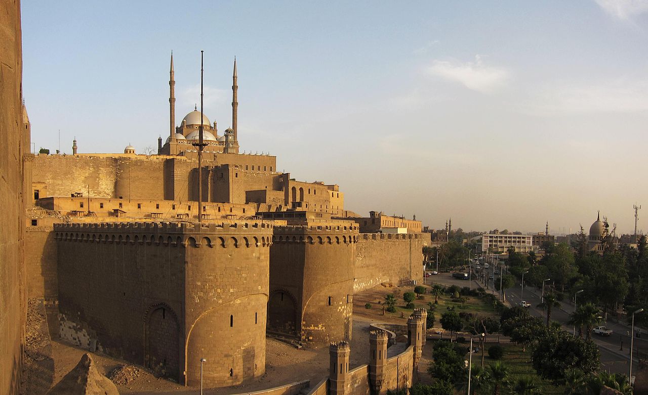
The Citadel of Cairo stood as the visible seat of Ottoman authority throughout the eighteenth century, yet the true levers of power lay elsewhere. While an Ottoman Pasha resided within the, issuing edicts in the name of the Sublime Porte, his commands frequently withered before reaching the city gates. Real control rested with the Mamluk beys, specifically the neo-Mamluk households that had reconstituted themselves after the Ottoman conquest of 1517. By 1700, these households had transformed Cairo into a theater of factional warfare, where the Qazdagli, Faqariyya, and Qasimiyya blocs vied for supremacy. The Pasha, frequently a rotating appointee with a tenure of a year or two, functioned less as a governor and more as a hostage to the most faction of the day. The economic engine that sustained this fractured political order was the *iltizam* system, a method of tax farming that bled the Egyptian peasantry to fund the Mamluk military machine. The state auctioned the right to collect taxes from specific villages or urban trades to the highest bidder, known as the *mültezim*. In theory, the *mültezim* remitted a fixed sum to the treasury and kept the surplus. In practice, Mamluk beys monopolized these positions, extracting extortionate revenues from the *fellahin* (peasants) and urban craftsmen. This revenue stream allowed the beys to purchase young Mamluks from the Caucasus, primarily Georgians and Circassians, to replenish their private armies. The *iltizam* thus created a self-perpetuating pattern: tax revenue bought soldiers, and soldiers enforced tax collection. Cairo itself reflected this duality of power. The Ottoman governor's influence rarely extended beyond the Citadel's walls, while the grand households of the beys dominated the urban fabric around the Azbakiyya Lake. These residences were not homes fortified barracks and administrative centers. The Qazdagli household, which rose to preeminence after the bloody civil strife of 1711, exemplified this structure. Founded by Mustafa al-Qazdagli, this faction systematically eliminated rivals through assassination and exile. By the mid-century, Ibrahim Katkhuda, a Qazdagli leader, ruled Cairo, dispensing patronage and controlling the janissary corps, which had long since integrated into the local commercial life. The fragility of Ottoman suzerainty became undeniable in 1768 with the rise of Ali Bey al-Kabir. A Georgian Mamluk of the Qazdagli faction, Ali Bey ruthlessly consolidated power, exiling his rivals and seizing the title of *Shaykh al-Balad* (Commander of the City). Seeing the Ottoman Empire distracted by war with Russia, he expelled the Ottoman Pasha and declared Egypt independent. His ambition extended beyond the Nile Valley; he dispatched forces to conquer the Hejaz and Syria, minting coins in his own name, a direct usurpation of the Sultan's prerogatives. For a brief window between 1769 and 1772, Cairo was the capital of a resurrected Mamluk sultanate. This independence collapsed not due to Ottoman military might, through internal betrayal. Ali Bey's most trusted general, Muhammad Bey Abu al-Dhahab, defected to the Porte, marching on Cairo and defeating his former master. The head of Ali Bey was sent to Constantinople, the Mamluk system itself survived, returning to a chaotic under the duumvirate of Murad Bey and Ibrahim Bey. The final decades of the eighteenth century brought Cairo to the brink of collapse. The internecine conflict between Murad and Ibrahim left the city, while the administration abandoned any pretense of public service. Infrastructure decayed; irrigation canals silted up, leading to agricultural failures. The population of Cairo, estimated at roughly 260, 000 in the late 1700s, faced repeated waves of bubonic plague. The outbreak of 1791 was particularly devastating, killing an estimated one-third of the city's inhabitants and wiping out entire Mamluk households. This demographic shock destabilized the labor market and severed trade links, leaving the economy in ruins.
Table 1. 1: Estimated Population and Plague Impact in Cairo (Selected Years)
Year
Event / Condition
Estimated Population
Notes
1700
Ottoman Provincial Stability
230, 000
Recovery from 17th-century stagnation.
1781
Plague Outbreak
240, 000
High mortality among Mamluk ranks.
1791
Great Plague
180, 000
Severe depopulation; economic paralysis.
1798
Pre-French Invasion
260, 000
Rapid recovery due to rural migration.
Commercial life in Cairo during this period relied heavily on the coffee trade. Yemeni coffee, imported through the Red Sea port of Suez and distributed from the Wikala of Dhu'l-Fiqar, generated immense wealth for the ruling beys. They levied heavy customs duties on this trade, as well as on spices and textiles from India. French merchants, who had established a presence in the city, grew increasingly vocal about the arbitrary taxes and seizures imposed by Murad Bey. These grievances would later provide a pretext for Napoleon's invasion. The beys, insulated in their palaces and consumed by petty rivalries, remained oblivious to the shifting geopolitical in Europe. They viewed the French merchants as sources of revenue, failing to recognize them as the vanguard of a new imperial threat. The intellectual life of Cairo, centered on Al-Azhar University, remained vibrant even with the political chaos. Scholars like Al-Jabarti recorded the events of the time with meticulous detail, providing a counter-narrative to the self-aggrandizing chronicles of the Mamluks. Al-Jabarti's writings reveal a society deeply skeptical of its rulers. The populace viewed the Mamluks not as legitimate sovereigns as foreign oppressors who had usurped the Sultan's authority. When the Mamluks rode through the streets, they did so surrounded by armed guards, a testament to the hostility of the Cairene street. By 1798, the Ottoman presence in Cairo had been reduced to a legal fiction. The Pasha was a prisoner in the Citadel, while Murad Bey and Ibrahim Bey divided the revenues of the country between them. The *iltizam* system had stripped the countryside bare, driving peasants into the city where they swelled the ranks of the urban poor. The Mamluk military, once a formidable force, had stagnated technologically, relying on medieval cavalry charges while European armies mastered artillery and disciplined infantry. This technological and administrative obsolescence set the stage for the shock of the French invasion. The Mamluks believed their own myth of invincibility, unaware that the world had changed around them. They prepared to meet modern cannons with swords, convinced that courage alone would secure their rule. The city they governed was a powder keg of social resentment, economic exhaustion, and political illegitimacy, waiting for a spark.
French Occupation and the Rise of Muhammad Ali Pasha 1798, 1848
Ottoman Provincial Governance and Mamluk Factionalism 1700, 1798
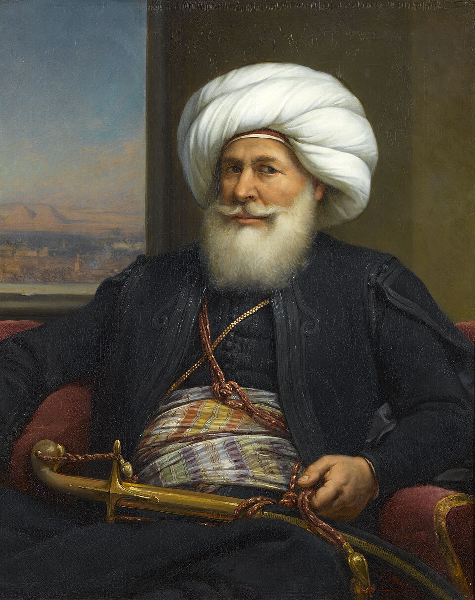
The French occupation of 1798 shattered the Mamluk illusion of invincibility. Napoleon Bonaparte's Army of the Orient did not defeat the Mamluk cavalry at the Battle of the Pyramids; it obliterated them with modern infantry squares and field artillery. The Mamluks, who had ruled Egypt for centuries, fled south, leaving Cairo open to a force that brought not only muskets also printing presses and savants. This brief, violent interlude (1798, 1801) exposed the technological abyss separating Ottoman Egypt from Europe and set the stage for a radical restructuring of the city. French administrators immediately reorganized Cairo's urban management. They divided the city into eight arrondissements (districts), each governed by a local diwan (council) accountable to French authority. This marked the attempt to impose a centralized, European-style municipal administration on Cairo's medieval quarter system. To facilitate troop movements, French engineers removed the gates that had traditionally sealed off neighborhoods (harat) at night, physically stripping away the insular security of the city's social fabric. The occupation's scientific arm, the *Institut d'Égypte*, established in the appropriated Qasim Bey palace, began the systematic mapping of the city. Their work, later published in the monumental *Description de l'Égypte*, produced the triangulation-based map of Cairo, freezing the city's 1800 layout in cartographic history. Resistance was immediate and bloody. The Revolt of Cairo in October 1798 centered on Al-Azhar University, the intellectual heart of Sunni Islam. French forces responded with ruthless efficiency, bombarding the mosque from the Citadel and storming its courtyard on horseback, a calculated desecration that horrified the populace. The revolt left over 2, 500 Egyptians dead and solidified the occupation as a hostile, alien presence. The French departure in 1801, following British and Ottoman intervention, left a power vacuum that plunged Cairo into chaos until the emergence of an Albanian commander named Muhammad Ali. Muhammad Ali Pasha did not inherit a stable state; he seized it. His consolidation of power culminated in the Citadel Massacre of March 1, 1811. Under the guise of a celebratory banquet for his son's military campaign, Muhammad Ali invited 470 Mamluk beys to the Citadel. As the procession moved through the narrow, rock-cut passage toward the Bab al-Azab gate, his troops sealed the exits and opened fire from the ramparts. The slaughter was absolute. This act of cold-blooded political cleansing ended Mamluk dominance forever and left Muhammad Ali as the sole master of Egypt. With his internal enemies liquidated, the Pasha turned Cairo into the engine of his dynastic ambitions. He viewed the city not as a collection of religious quarters, as a production center for his military machine. The district of Bulaq, Cairo's port on the Nile, transformed into an industrial complex. By 1820, it housed the government arsenal, a textile factory, and the Amiriya Press (established 1820), which printed military manuals and technical treatises. This was state-led industrialization on a unseen in the region. The screak of and the smoke of foundries began to compete with the call to prayer, signaling a shift from an artisanal economy to a regimented, state-monopolized production system. The Pasha also reshaped the city's skyline to reflect his new order. He ordered the demolition of the Mamluk palaces within the Citadel, including the Great Iwan and the Ablaq Palace, erasing the architectural legacy of his predecessors. In their place, he commissioned the Alabaster Mosque (begun 1830), a massive structure in the Ottoman imperial style. Its pencil-shaped minarets, visible from every rooftop in Cairo, served as a constant visual reminder of his authority and his cultural orientation toward Istanbul, even as he fought for independence from it. the Citadel, the urban underwent slow significant sanitary engineering. The chaotic, disease-ridden ponds of Azbakiyya, long a source of pestilence during the flood season, were ordered drained and filled in the 1830s. This reclamation project aimed to create a European-style park and district, anticipating the westward expansion of the city that would accelerate under his successors. yet, public health remained a severe problem. The cholera epidemic of 1831 killed thousands in Cairo alone, overwhelming the rudimentary quarantine measures established by the newly formed Board of Health. A second major outbreak in 1848 claimed over 6, 000 lives in the city within two months, proving that industrial modernization had yet to conquer biological vulnerability. Data from this era reveals a city in transition. The census of 1848, one of the earliest statistical efforts of its kind in the Middle East, recorded a population of approximately 256, 000 for Cairo. This figure suggests that even with the political upheavals and plagues, the city's population had begun to recover from the lows of the late 18th century. The census itself was a tool of control, designed to track conscripts for the Pasha's wars and laborers for his factories. By the time Muhammad Ali died in 1849, Cairo was no longer a medieval Ottoman provincial capital; it was the headquarters of an aggressive, modernizing state, its streets scarred by the violence of its birth and the soot of its new industries.
Key Events in Cairo's Transformation (1798, 1848)
Year
Event
Impact on Cairo
1798
French Occupation & Revolt of Cairo
Al-Azhar bombarded; city divided into 8 administrative districts.
1811
Citadel Massacre
Elimination of Mamluk elite; consolidation of Muhammad Ali's power.
1820
Bulaq Press Established
Start of mass printing; Bulaq becomes an industrial zone.
Thousands dead; exposes failure of early sanitary reforms.
1848
Modern Census
Cairo population recorded at ~256, 000; state surveillance increases.
Khedival Urban Planning and Sovereign Debt Crisis 1863, 1882
Khedive Ismail assumed the throne in 1863 with a declaration that would define the two decades of Egyptian history: "My country is no longer in Africa; we are part of Europe." This was not a rhetorical flourish a statement of intent that initiated a period of aggressive modernization, financed by a volatile combination of cotton revenues and predatory European lending. Ismail aimed to remodel Cairo into a "Paris on the Nile," a project that physically bifurcated the city and mortgaged the nation's sovereignty to foreign creditors.
The economic engine for this transformation was the American Civil War (1861, 1865). As the Union blockade choked off cotton supplies from the American South, British textile mills turned to Egypt. The price of Egyptian cotton skyrocketed, quadrupling in value between 1861 and 1864. This "white gold" poured capital into the Egyptian treasury, encouraging Ismail to embark on infrastructure projects of a previously unimagined. The state revenue jumped from roughly £4 million to over £13 million during the war years, creating a dangerous illusion of perpetual solvency.
Ismail entrusted the physical restructuring of Cairo to Ali Mubarak, his Minister of Public Works and a Paris-educated engineer. Mubarak's mandate was to create a new city alongside the old, rather than rehabilitating the medieval core. The result was the Ismailiya quarter, a district characterized by wide, geometric boulevards, gas lighting, and European-style architecture. This new zone stood in clear contrast to the winding, organic street patterns of the historic city. The Qasr al-Nil, completed in 1871, physically linked this new district to the western bank of the Nile, cementing the westward expansion of the capital. By 1872, the city had two distinct faces: the European quarter for the elite and foreigners, and the "native" quarter where the majority of Cairenes lived in deteriorating conditions.
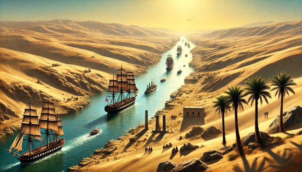
The apex of this modernization drive was the opening of the Suez Canal in November 1869. To host the visiting European royalty, including Empress Eugénie of France, Ismail ordered the construction of the Cairo Opera House, which was completed in a frantic five months at a cost of £60, 000. The festivities themselves were legendary in their excess, with reports estimating the total cost of the celebrations and associated infrastructure upgrades at over £2 million. This event was intended to showcase Egypt as a civilized, modern power, yet it occurred just as the economic was turning.
The end of the American Civil War brought a crash in cotton prices, yet Ismail's spending did not contract. To maintain the pace of development, the Khedive turned to European financial markets. The banking houses of London and Paris, including Oppenheim and Rothschild, facilitated a series of loans with increasingly usurious terms. The method of these loans were designed to entrap the borrower. For instance, a loan might be issued with a face value of £32 million, after discounts and commissions, the Egyptian treasury would receive less than £20 million, while remaining liable for the full principal plus interest. Real interest rates frequently exceeded 20 percent.
Egyptian Sovereign Debt Escalation (1863, 1876)
Year
Approximate Foreign Debt (£ Sterling)
Primary Economic Driver/Event
1863
3, 000, 000
Accession of Ismail; Cotton Boom begins
1868
15, 000, 000
Post-Civil War Cotton Crash; Infrastructure spending
1873
45, 000, 000
Oppenheim Loan; Peak borrowing
1876
94, 000, 000
State Bankruptcy; Caisse de la Dette established
By 1875, the financial situation had become desperate. In a last-ditch effort to service the debt, Ismail sold Egypt's 44 percent share in the Suez Canal Company to the British government for £4 million. The relief was temporary. The money was immediately absorbed by creditors, leaving Egypt with neither the shares nor the capital. In 1876, Ismail was forced to suspend payment on treasury bills, declaring state bankruptcy. The total foreign debt had ballooned from £3 million at his accession to approximately £94 million.
The consequences of this default were immediate and severe. European powers established the Caisse de la Dette Publique (Commission of the Public Debt) to manage Egypt's finances. This body, staffed by European controllers, prioritized debt service over internal development or public welfare. In 1877, more than 60 percent of Egypt's total revenue was diverted to pay foreign bondholders. To meet these demands, the tax load on the Egyptian peasantry (fellahin) was increased ruthlessly. The Muqabala law, which allowed landholders to pay six years of taxes in advance in exchange for future relief, was one of desperate schemes to raise cash that failed to the bleeding.
This financial colonization sparked intense domestic unrest. The "Dual Control" system, where a British official oversaw revenue and a French official oversaw expenditure, stripped the Khedive of his sovereignty. When Ismail attempted to assert independence in 1879 by dismissing the European ministers, the European powers pressured the Ottoman Sultan to depose him. Ismail was sent into exile, and his son Tewfik was installed as a puppet ruler, tasked with enforcing the austerity measures dictated by the creditors.
The of sovereignty and the economic hardship faced by the army and the peasantry coalesced into the Urabi Revolt (1879, 1882). Led by Colonel Ahmed Urabi, a native Egyptian officer, the movement demanded a constitution, parliamentary oversight of the budget, and a halt to foreign interference. The slogan "Egypt for the Egyptians" resonated across the social spectrum, from the disgruntled military to the overtaxed rural population. By 1881, Urabi had cornered Khedive Tewfik, forcing the appointment of a nationalist cabinet.
The prospect of a nationalist government repudiating the debt or seizing the Suez Canal was unacceptable to Britain and France. In the summer of 1882, anti-European riots in Alexandria provided the pretext for intervention. The British Royal Navy bombarded Alexandria in July, reducing large sections of the city to rubble. This was followed by a full- invasion. British forces defeated Urabi's army at the Battle of Tel el-Kebir in September 1882. Two days later, British troops entered Cairo, marking the beginning of a "temporary" occupation that would last until 1956. The dream of a sovereign, European-style Cairo had ended in military conquest, leaving behind a city divided by class and architecture, and a nation shackled by the very debt incurred to modernize it.
British Colonial Administration and Cairene Nationalist Movements 1882, 1952
French Occupation and the Rise of Muhammad Ali Pasha 1798, 1848
The British occupation of Cairo, commencing in 1882, established a system of governance defined by fiscal austerity and administrative duality. Lord Cromer, the British Consul-General, erected a "Veiled Protectorate" where British advisors manipulated Egyptian ministers like marionettes behind a curtain of Ottoman legality. Cromer's primary objective remained the repayment of Egypt's sovereign debt to European creditors. To achieve this, he turned the Nile Valley into a monocultural cotton plantation for Lancashire mills. Cairo functioned as the bureaucratic nerve center for this extraction, yet the city itself received little investment for social welfare. Education budgets frequently hovered one percent of total government expenditure. The British administration viewed public education not as a route to national development, as a factory for producing low-level clerks or, worse, a breeding ground for sedition. Under this regime, Cairo bifurcated into two distinct urban entities. The western districts, including Ismailiya and the newly developed Garden City, mimicked the boulevards of Paris, complete with electricity, macadamized roads, and the lush lawns of the Gezira Sporting Club. Here, British officials and the local Turco-Circassian elite lived in a sanitized bubble. Conversely, the "native" quarters of Bulaq, Sayyida Zeinab, and Old Cairo suffered from malign neglect. Sanitation infrastructure in these dense districts remained nonexistent. When cholera struck in 1883 and again in 1902, mortality rates in the indigenous quarters soared, while the colonial enclaves remained largely untouched. The British response involved invasive sanitary policing, burning infected belongings and enforcing quarantines, which the Cairene population viewed as assaults on their privacy and dignity rather than public health measures. The demographic pressure on the capital intensified throughout the occupation. Cairo's population swelled from approximately 374, 000 in 1882 to over 2 million by 1947. This explosion resulted from rural migration driven by land consolidation and the volatility of global cotton prices. The new arrivals packed into the older quarters, creating a density that the colonial administration's ability to police or cordon off. It was from these crowded alleyways that the nationalist resistance drew its foot soldiers. The Dinshaway Incident of 1906, though it occurred in the Delta, radicalized the Cairene urban intelligentsia. Mustafa Kamil and his Watani Party used the city's printing presses to disseminate a message of immediate evacuation, turning Cairo's coffeehouses into forums of sedition. The rupture came in 1919. Following the British arrest and exile of the nationalist leader Saad Zaghloul, Cairo erupted. The 1919 Revolution was not a political dispute; it was a total mobilization of the city. Students from Al-Azhar and the secular university paralyzed the tramways. Coptic priests and Muslim sheikhs demonstrated unity by preaching in each other's houses of worship. In a move that shocked the colonial establishment, upper-class Egyptian women, led by Huda Sha'arawi, marched through the streets of downtown Cairo, British bayonets. The colonial response was lethal. British troops fired on demonstrators, killing at least 800 Egyptians between March and July. Yet, the paralysis of the capital forced London to problem the unilateral Declaration of Independence in 1922, a document that granted nominal sovereignty while reserving four "essential" powers to Britain, including the security of imperial communications and the defense of Egypt.
Cairo Urban Expansion and Political Violence (1882, 1952)
Mass protests in Cairo radicalize the urban effendiyya class.
1919
1919 Revolution
800+ killed. Tram lines cut. Women's demonstrations in Ismailiya district.
1942
Abdeen Palace Incident
British tanks surround King Farouk's palace to force Wafd government.
1947
Census Population
Population reaches ~2. 09 million. High density in "native" quarters.
1952
Black Saturday (Cairo Fire)
~750 buildings destroyed. Shepheard's Hotel burned. 26+ deaths.
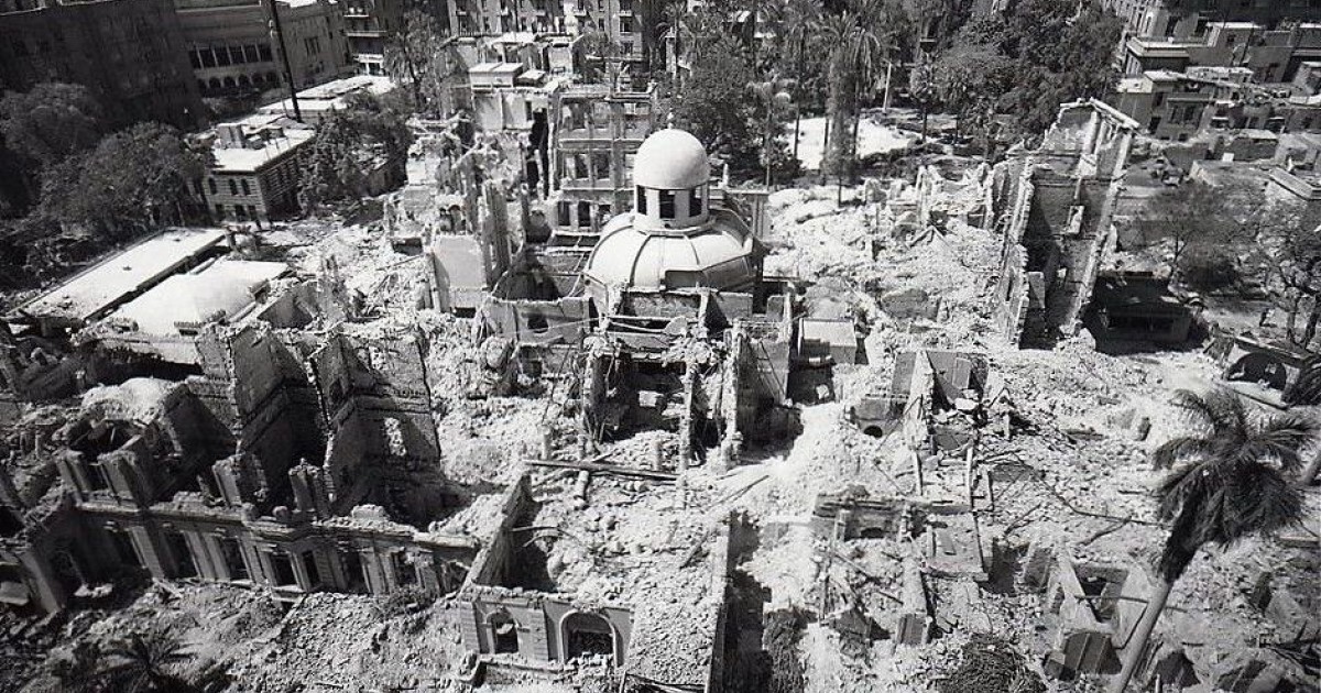
The interwar period, frequently termed Egypt's "Liberal Age," proved to be a facade of parliamentary democracy masking a three-way power struggle between the Wafd Party, the Palace, and the British Residency. Cairo served as the stage for this dysfunction. The 1923 Constitution theoretically the electorate, yet the King frequently dissolved parliament, and the British High Commissioner retained the final word on security. This political impotence reached its nadir on February 4, 1942. With Rommel's Afrika Korps advancing, the British Ambassador Sir Miles Lampson ordered tanks to surround Abdeen Palace. He presented King Farouk with an ultimatum: appoint a pro-British Wafd government or abdicate. Farouk capitulated. While this secured the Allied rear during World War II, it destroyed the legitimacy of both the monarchy and the Wafd in the eyes of the Cairene public. In the vacuum left by the discredited elite, radical extra-parliamentary groups seized the street. The Muslim Brotherhood, founded in 1928, established a formidable network of branches across Cairo, providing social services, clinics, and schools where the state had failed. Their paramilitary wing, the Secret Apparatus, engaged in a campaign of assassinations against judges and ministers. Simultaneously, communist cells and the Young Egypt (Green Shirts) movement organized strikes and student riots. By the late 1940s, Cairo was a city on edge, plagued by inflation, unemployment, and the humiliating presence of British troops who refused to evacuate the Suez Canal zone. The tension broke on January 26, 1952, a day etched in history as "Black Saturday." Following a massacre of Egyptian auxiliary police by British forces in Ismailia the previous day, crowds gathered in downtown Cairo. What began as a police protest mutated into a systematic burning of the symbols of European presence and aristocratic privilege. The mob targeted the turf of the colonial elite: the Turf Club, the Rivoli Cinema, the Automobile Club, and the iconic Shepheard's Hotel. Witnesses described organized groups using petrol to torch specific buildings while looting others. The fire raged for hours as the King hesitated to deploy the army. By sunset, the heart of modern Cairo, the "Paris on the Nile" built by Khedive Ismail, lay in ashes. Approximately 750 buildings were destroyed or damaged. The Cairo Fire was not a riot; it was the funeral pyre of the old regime. The smoke that billowed over the Nile signaled that the liberal experiment was over. Six months later, the Free Officers Movement, led by Gamal Abdel Nasser, executed a coup that swept away the monarchy, the pashas, and the British occupation, opening a new chapter in the city's millennia-long history.
Post-1952 Revolution Industrialization and Socialist Architecture
The 1952 Free Officers coup did not depose a monarch; it initiated a systematic spatial reordering of Cairo intended to erase the Khedivial "Paris on the Nile." Gamal Abdel Nasser and his Revolutionary Command Council viewed the European-style downtown and the garden suburbs of Maadi and Heliopolis as architectural manifestations of colonial subservience. To project the power of the new republic, the state turned to two primary method: heavy industrialization and the construction of massive, state-planned urban districts. This era replaced the ornate Italianate plaster of the fin de siècle with the unadorned concrete of socialist brutalism, fundamentally altering the city's metabolism from a commercial hub to an industrial production center.
The crown jewel of this transformation was Helwan. Once a therapeutic retreat for the pasha class known for its sulfur springs and winter palaces, Helwan was repurposed by decree in 1954 to become the "industrial " of the revolution. The regime established the Egyptian Iron and Steel Company (Hadisolb) in 1955, with production commencing in 1958. While West German firm Demag provided initial technology, the Soviet Union later supplied the technical and financial backing necessary to expand operations, cementing the facility as a symbol of non-aligned self-sufficiency. By the mid-1960s, Helwan housed not only the steelworks also factories for cement, textiles, and automobiles (El Nasr Automotive Manufacturing Company). This industrial zoning decision had catastrophic long-term environmental consequences, trapping toxic emissions against the Mokattam hills and permanently altering the air quality of the southern capital.
The economic logic of the Nasserist state demanded a new urban form to house the burgeoning technocratic class and the military elite. In 1956, the architect Sayed Karim presented the master plan for Nasr City (Medinet Nasr), a massive eastward expansion into the desert. Unlike the organic growth of Old Cairo or the radial planning of downtown, Nasr City employed a rigid orthogonal grid, characterized by wide boulevards designed to accommodate military parades and rapid vehicular movement. The district was intended to serve as a new administrative capital, shifting the center of away from Tahrir Square. Government ministries, the Central Agency for Public Mobilization and Statistics (CAPMAS), and the Al-Azhar University campus were relocated here. Karim's original vision included the concept of the "socialist villa", modest, detached homes for the middle class, yet economic realities forced a shift toward high-density apartment blocks.
State-led construction introduced a new architectural typology: the masakin (popular housing). Between 1952 and 1965, the government constructed approximately 15, 000 public housing units. While statistically insignificant compared to the population boom, these projects, such as the Workers' City in Imbaba and the Zeinhom blocks, established the state as the primary provider of shelter. These structures prioritized function over form, stripping away the courtyards and ornamentation that defined Cairene domestic architecture for centuries. The buildings were standardized, repetitive concrete slabs, frequently arranged in parallel rows that ignored local wind patterns and solar orientation. This uniformity was ideological; it signaled a commitment to egalitarianism, even if the quality of construction frequently rapidly.
The Maspero Television Building, completed in 1960 on the banks of the Nile, stands as the most potent architectural symbol of this era. Designed by Naoum Shebib, the massive curved structure housed the state media apparatus, the voice of Pan-Arabism. Its construction required the demolition of existing riverfront properties, physically asserting the regime's dominance over the prime real estate of the capital. Maspero was not just an office building; it was a of information, guarded by tanks during times of unrest, and remained the nerve center of the Egyptian state's narrative control until the media fractured in the 21st century.
Industrialization triggered a demographic explosion that overwhelmed the state's planning capacities. The pledge of factory jobs in Helwan and Shubra el-Kheima drew millions from the Delta and Upper Egypt. The state's inability to build housing at the pace of migration led to the densification of existing districts and the birth of the ashwa'iyyat (informal settlements). By 1966, Cairo's population had surged to over 4. 2 million, up from 2 million in 1947. The table demonstrates the correlation between the industrial push and population growth during the serious years of the socialist experiment.
Year
Cairo Population
Key Industrial/Political Context
1947
2. 09 Million
Pre-Revolution; End of British military presence in city
1960
3. 35 Million
Five-Year Industrial Plan launched; Maspero opens
1966
4. 22 Million
Peak of Nasserist industrial employment; High Dam construction
1976
6. 10 Million
Post-1973 War; Beginning of Infitah (Open Door) policy
The legacy of this era faced a definitive reckoning in the 2020s. The Egyptian Iron and Steel Company in Helwan, once the pride of the revolution, suffered from decades of neglect, technological obsolescence, and accumulated debts exceeding 8. 5 billion EGP. In January 2021, the General Assembly of the company decided to liquidate the factory, marking the official death of the Nasserist industrial dream. The sprawling complex, which once employed 25, 000 workers, had been operating at less than 11% capacity. Its closure signaled the state's pivot away from the import-substitution industrialization model toward a new economic paradigm focused on real estate speculation and logistics.
Nasr City, too, has mutated far beyond Sayed Karim's master plan. By 2026, the district had become a zone of extreme density, its "socialist villas" demolished to make way for high-rise towers. The wide boulevards, originally meant for fluid movement, became choked arteries of traffic, prompting the construction of a massive network of flyovers and the East Cairo Monorail in the early 2020s. These concrete ribbons slice through the neighborhood, casting shadows over the mid-century blocks. The Maspero Triangle, the slum area that grew in the shadow of the television building, was razed in 2018 to make way for luxury high-rises, completing the pattern of erasure. The socialist city, built to the worker and the bureaucrat, has been systematically dismantled and redeveloped to serve the flow of global capital.
Informal Settlement Expansion and Ashwa'iyyat Demographics 1974, 2011
Khedival Urban Planning and Sovereign Debt Crisis 1863, 1882
The post-1973 era marked a definitive rupture in Cairo's urban trajectory, driven not by master plans by the raw mechanics of survival and speculation. President Anwar Sadat's 1974 *Infitah* (Open Door) policy dismantled the Nasserist social contract, inviting foreign capital that flowed almost exclusively into luxury real estate and tourism. While cranes erected high-rises in Zamalek and Mohandessin for the new economic elite, the state ceased producing affordable housing for the working class. The result was a massive, unauthorized explosion of the built environment: the *ashwa'iyyat* (haphazard areas). By the early 1980s, the informal sector was supplying over 80 percent of all new housing units in Greater Cairo, a statistic that exposed the irrelevance of official urban planning. This expansion followed a specific, replicable economic logic. Unlike the shantytowns of Latin America or South Asia, Cairo's informal settlements were not composed of tin shacks of multi-story reinforced concrete structures. Small- developers or families purchased agricultural land on the city's periphery, illegally converting it from farming to residential use, and subdivided it into small plots. Construction proceeded without permits, engineering oversight, or municipal infrastructure. The "red brick belt" encircled the capital, consuming prime Nile Delta farmland at a rate of hundreds of hectares annually. Areas such as Bulaq al-Dakrur, Dar el-Salam, and Warraq grew into dense urban behemoths, functioning as self-contained cities with their own informal power grids, water networks, and legal codes. The state's withdrawal from these areas created a vacuum that was frequently filled by Islamist organizations. The district of Imbaba became the most potent symbol of this parallel governance. By the early 1990s, the militant group al-Gama'a al-Islamiyya had established the "Republic of Imbaba," enforcing a strict moral code and providing the social services the government had abandoned. This challenge to state sovereignty culminated in December 1992, when the Mubarak regime launched a massive security operation. Over 12, 000 troops and Central Security Forces laid siege to the neighborhood for weeks, arresting hundreds and asserting violent control over the district. The siege of Imbaba marked the securitization of urban policy, where informal areas were viewed not as development challenges as incubators of terrorism. Nature exposed the structural fragility of this unplanned growth on October 12, 1992. A 5. 8 magnitude earthquake struck southwest of Cairo, killing 561 people and injuring thousands. While media attention focused on the collapse of a 14-story building in Heliopolis, the devastation was most widespread in the older quarters and the hastily built informal extensions. The disaster revealed that hundreds of thousands of Cairenes lived in structures that were structurally unsound. The government's response was a mix of panic and temporary rehousing, yet the fundamental driver, the absence of affordable legal housing, remained unaddressed.
Metric
Informal Areas (e. g., Dar el-Salam)
New Desert Cities (e. g., New Cairo)
Population Density (2006)
~77, 000 inhabitants/km²
< 500 inhabitants/km²
Housing Production Share (1990s)
~80% of total units
~15% (mostly vacant)
Legal Status
Unregistered / Wad' al-yad
State-sanctioned / Registered
Infrastructure Access
Informal tapping / Retroactive
Pre-planned / Oversized
Throughout the 1990s and 2000s, the Mubarak regime attempted to divert population growth to the desert through the New Towns program (e. g., 6th of October City, New Cairo). This strategy failed catastrophically in demographic terms. The desert cities remained ghost towns for years, accessible only to the wealthy who owned cars, while the poor continued to densify the valley. The passing of Law 4 of 1996, which liberalized rents for new contracts, further squeezed the lower-middle class, pushing more families into the informal market where ownership, yet legally precarious, offered security against eviction. By 2008, estimates suggested that over 60 percent of Greater Cairo's population resided in informal areas. The distinction between "unplanned" (agricultural land encroachments) and "unsafe" (slums on hazardous terrain) became lethally clear on September 6, 2008. In the Manshiyat Naser district, massive limestone boulders broke loose from the Muqattam plateau, crushing the shantytown of Duweiqa. Official figures 119 deaths, though residents and local NGOs insisted the toll was far higher, with bodies remaining buried under thousands of tons of rock. The Duweiqa rockslide forced the state to acknowledge the physical danger of its neglect. In response, the government established the Informal Settlements Development Fund (ISDF) to map and eradicate "unsafe areas," marking a shift from ignoring these zones to actively targeting them for demolition and redevelopment. By 2011, the demographic weight of the *ashwa'iyyat* had tipped the political. These areas, long marginalized and subjected to police harassment rather than municipal service, became reservoirs of deep anti-regime resentment. The social contract had been broken for decades; the state provided neither security nor housing, only corruption and repression. When the uprising began in January, the mobilization power of these densely packed, aggrieved communities proved decisive in overwhelming the security apparatus that had once besieged them.
Tahrir Square Political Mobilization and Security Crackdowns 2011, 2013
The eighteen days of the 2011 uprising transformed Tahrir Square from a traffic circle into a sovereign city-state within Cairo. Between January 25 and February 11, the square functioned as a field hospital, a supply depot, and a defensive fortification. The Ministry of Health confirmed 846 deaths nationwide during this period, with a high concentration in the capital. Violence peaked on February 2, 2011, during the "Battle of the Camel," when regime-aligned thugs charged the square on horses and camels. Defenders manned barricades at the entrances from the Egyptian Museum and Qasr al-Nil, using rocks and Molotov cocktails to repel the assault. This medieval-style siege failed to break the occupation, yet it established a pattern of state-sponsored irregular warfare that would plague the city for the two years. Following Hosni Mubarak's resignation, the Supreme Council of the Armed Forces (SCAF) assumed control, and the violence shifted from police repression to military confrontation. On October 9, 2011, military police attacked a Coptic Christian march at the Maspero television building. Armored Personnel Carriers (APCs) drove at high speed into the crowds, crushing protesters. Autopsy reports and human rights investigations documented 28 deaths, with at least 12 victims mangled by heavy vehicles. State media simultaneously incited citizens to "protect the army" from Coptic attackers, triggering sectarian street fighting in downtown Cairo. This event marked the end of the "army and people are one hand" slogan that had characterized the initial uprising. The conflict intensified in November 2011 on Mohamed Mahmoud Street, a connector between Tahrir Square and the Ministry of Interior. For six days, Central Security Forces (CSF) engaged in street battles with protesters, using tear gas so saturated it permeated apartments blocks away. Police snipers targeted the eyes of demonstrators. Lieutenant Mahmoud Sobhy El-Shenawy, dubbed the "Eye Sniper," was later sentenced to three years in prison after video evidence showed him aiming for heads and receiving praise from colleagues for hitting eyes. Over 40 people died in these clashes. The violence destroyed the physical infrastructure of the district; walls were erected to block streets, turning downtown Cairo into a maze of concrete blocks that disrupted urban flow for years. In December 2011, clashes at the Cabinet building resulted in the burning of the Institut d'Égypte, a research center established by Napoleon Bonaparte in 1798. The fire consumed approximately 192, 000 books and journals, including a priceless edition of the *Description de l'Égypte*. Volunteers formed human chains to salvage charred manuscripts from the smoldering ruins, a desperate attempt to save Cairo's historical memory amidst the chaos. The burning of the Institute served as a grim symbol of the degradation of state institutions and the collateral damage of the power struggle between revolutionaries and the military junta. The election of Mohamed Morsi in June 2012 did not end the street mobilization. Instead, the locus of violence shifted. On December 5, 2012, supporters of the Muslim Brotherhood attacked a sit-in opposing Morsi's constitutional declaration at the Itihadiya Presidential Palace. The clashes left at least 11 dead. Unlike previous confrontations involving uniformed police, this violence pitted civilian factions against one another, introducing a new phase of civil strife. The Brotherhood's deployment of cadres to clear the sit-in demonstrated their willingness to use physical force to secure political objectives, further polarizing the capital. Sexual violence became a systematic weapon of terror in Tahrir Square during this period. Mobs of men employed "circle of hell" tactics, surrounding women, stripping them, and assaulting them with fingers and sharp objects. Between June 28 and July 2, 2013, Human Rights Watch documented 91 mob sexual assaults in the square. These attacks were not random; they occurred with impunity and deterred women from participating in political gatherings. Volunteer groups like OpAntiSH and Tahrir Bodyguard formed to intervene, wearing protective gear and using extraction teams to pull victims from the centers of these mobs, frequently facing violent resistance from the attackers. The mobilization culminated on June 30, 2013, with mass protests demanding Morsi's removal. The military claimed 33 million people took to the streets nationwide, a figure statistically impossible given Egypt's population and street capacity. Independent analysis suggested the numbers were significantly lower, though still in the millions. In Cairo, crowds filled Tahrir Square and the perimeter of the Itihadiya Palace. Military helicopters dropped flags on the demonstrators, signaling the army's alignment with the street movement. This show of force provided the pretext for the military's ultimatum and subsequent removal of Morsi on July 3, 2013. The security apparatus, having allowed the protests to swell, moved quickly to reassert total control, setting the stage for the dispersal of the Rabaa al-Adawiya sit-in and the end of Cairo's era of open street politics.
Major Incidents of Political Violence in Cairo (2011, 2013)
Event
Date
Location
Key Details
Estimated Deaths
Battle of the Camel
Feb 2, 2011
Tahrir Square
Pro-regime thugs on horses/camels charge sit-in.
11 (in specific attack)
Maspero Massacre
Oct 9, 2011
Maspero TV Building
Military APCs crush Coptic protesters.
28
Mohamed Mahmoud
Nov 19, 24, 2011
Downtown Cairo
Police snipers target eyes; heavy tear gas use.
40+
Cabinet Clashes
Dec 16, 20, 2011
Qasr al-Aini Street
Burning of Institut d'Égypte.
17
Itihadiya Clashes
Dec 5, 2012
Heliopolis
Brotherhood cadres attack opposition sit-in.
11
Nile Hydrology, Water Scarcity, and Sanitation Infrastructure
British Colonial Administration and Cairene Nationalist Movements 1882, 1952
The Nile's annual pulse dictated Cairo's survival for centuries, a hydraulic tyranny that governed feast and famine long before modern engineering intervened. Throughout the 1700s, the city's fate rested on the summer floodwaters rising at the Roda Nilometer. A drop of a few cubits meant starvation; an excess meant destruction. The low Niles of 1783 and 1784 illustrate this precarious existence, triggering a famine that decimated the population and weakened the Mamluk state prior to the French invasion. During this era, the Khalij al-Masri canal functioned as the city's aorta, conveying floodwaters into the heart of Cairo. Yet, for much of the year, this waterway stagnated into a fetid open sewer, receiving the runoff of a city dependent on porous cesspits and water carriers. Muhammad Ali Pasha attempted to break this pattern in the mid-19th century by ordering the construction of the Delta Barrage. Intended to regulate flow and expand cotton cultivation, the structure suffered from foundational defects and remained largely inoperative until British engineers reinforced it in the 1880s. The colonial administration, driven by a fear of contagion following the cholera epidemics of 1883 and 1895, targeted the city's traditional hydrology. In 1897, authorities began filling the Khalij al-Masri, burying the historic canal to create a tramway and road, Port Said Street. This sanitary intervention failed to prevent the devastating cholera outbreak of 1902, which killed over 34, 000 people across Egypt and exposed the lethal inadequacy of Cairo's water infrastructure. The completion of the Aswan High Dam in 1970 marked the definitive end of the Nile's natural flood pattern, granting Egypt year-round water control inflicting severe ecological penalties on Cairo. The cessation of sediment deposition forced the use of chemical fertilizers, while the stabilized river level caused the water table to rise, threatening the foundations of Islamic monuments with saline groundwater. By the early 1980s, the city's sanitation system collapsed under the weight of a population explosion. Raw sewage frequently flooded the streets of upscale districts and informal settlements alike. The Egyptian government, unable to finance a solution alone, accepted massive funding from the United States and the United Kingdom for the Greater Cairo Wastewater Project. This multi-billion dollar engineering feat, one of the largest of its kind globally, tunneled beneath the city to divert waste to the Gabal el-Asfar treatment plant, temporarily averting a public health catastrophe. By 2026, the focus shifted from wastewater management to an existential deficit in freshwater supply. Data from the Ministry of Water Resources and Irrigation indicates that Egypt's per capita water share dropped to approximately 500 cubic meters annually, crossing the United Nations threshold for absolute water scarcity. The filling of the Grand Ethiopian Renaissance Dam (GERD) exacerbated this deficit. Egyptian officials reported in early 2026 that the dam's operation had already withheld billions of cubic meters of water, forcing the state to reuse agricultural drainage water and impose strict rationing. The Nile, once an infinite provider, represents a zero-sum geopolitical contest.
Cairo Water & Sanitation Metrics (1800, 2026)
Metric
1800 (Ottoman)
1907 (British)
1985 (Mubarak)
2026 (Sisi)
Population
~260, 000
654, 000
~8 Million
~22 Million
Water Source
Nile & Wells
Reticulated Network (Partial)
Aswan High Dam Regulated
Nile, Desalination, Reuse
Per Capita Water
Variable (Flood dependent)
~1, 000+ m³ (Est.)
~900 m³
~490 m³
Sanitation Method
Cesspits / Canal dumping
Bucket removal / Early sewers
Overloaded sewers / Flooding
Treatment Plants / Leakage
The in infrastructure investment defines the current hydro-political reality. While the New Administrative Capital receives a dedicated supply line with a capacity of 1. 5 million cubic meters per day, Old Cairo struggles with an aging network that loses nearly 30 percent of its potable water to leakage. Residents in informal areas frequently rely on public taps or expensive private trucking, creating a clear hydraulic apartheid. The government's 2026 strategy relies heavily on desalination and wastewater recycling to plug the gap, yet the fundamental arithmetic remains unforgiving: the population grows, the Nile shrinks, and the pipes beneath the old city continue to rust.
Air Quality Metrics and the Black Cloud Phenomenon
For centuries, the air of Cairo has carried the weight of its geography. Since the eighteenth century, and likely long before, the city has endured the Khamasin, a fifty-day spring wind that scours the Western Desert and deposits tons of particulate matter onto the Nile Delta. French soldiers under Napoleon Bonaparte in 1798 recorded these suffocating dust storms, noting how the sky turned a blood-red tint before visibility entirely. This natural baseline of coarse dust (PM10) defined the respiratory load of the city for generations, a seasonal affliction accepted as the price of living on the desert's edge.
The mid-twentieth century introduced a more toxic, permanent to this atmosphere. The industrialization drive of the 1950s, specifically the establishment of heavy cement and steel industries in Helwan to the south and Shubra El-Kheima to the north, encircled the city in a ring of smokestacks. By the 1970s, Helwan's cement factories were belching thousands of tons of cement kiln dust annually. This gray smog, rich in heavy metals and sulfur dioxide, settled over the valley, trapped by the Muqattam Hills. The pollution was constant, yet it absence the acute, suffocating density that would later define Cairo's autumns.
That changed in the fall of 1999. Residents woke to a dark, heavy fog that did not lift with the morning sun. It burned the eyes and tasted of charred wood. This was the birth of the "Black Cloud" (al-Sahaba al-Sawda), a phenomenon that has plagued the capital every October and November for over two decades. The cloud was not a single source event a convergence of agricultural malpractice and meteorology. In the Nile Delta, farmers harvested rice and, absence to process the massive volume of silica-rich straw, burned it in open fields. Simultaneously, a thermal inversion , a meteorological lid of warm air sitting atop cold air, trapped this smoke close to the ground, preventing its dispersion into the upper atmosphere.
The metrics of this pollution reveal a public health disaster. During Black Cloud episodes, concentrations of PM2. 5, fine particulate matter capable of penetrating the bloodstream, frequently spike to levels exceeding 300 micrograms per cubic meter, more than twenty times the World Health Organization's safe limit of 15 micrograms. A World Bank report analyzing data from 2017 estimated that air pollution in Greater Cairo resulted in approximately 19, 000 premature deaths annually. The economic cost is equally severe, eroding between 1. 4 percent and 2. 5 percent of Egypt's GDP through healthcare expenditures and lost productivity.
Cairo Air Quality Milestones and Metrics (1999, 2026)
Period
Event / Metric
Primary Driver
Fall 1999
recorded "Black Cloud"
Rice straw burning + Thermal Inversion
2000, 2010
PM10 exceeds 150 µg/m³ annual avg
Vehicle emissions, Helwan Cement, Open burning
2017
19, 000 estimated premature deaths
PM2. 5 exposure (World Bank Data)
2020
$200 Million World Bank Project
Pollution abatement & waste management
2023, 2025
Rice straw recycling rate hits ~90%
Govt collection for fertilizer/cement fuel
2026 (Proj)
Daily PM2. 5 avg: 35, 60 µg/m³
Traffic & Construction dust (New Capital works)
Government intervention has evolved from denial to active management. Early attempts in the 2000s to criminalize straw burning failed due to the absence of viable alternatives for farmers. By 2020, a shift in strategy monetized the waste. The Ministry of Environment, in partnership with private contractors, established collection sites where farmers could sell straw. This material is pressed and sold to cement factories, ironically, the old polluters of Helwan, to be used as biofuel. Reports from 2024 and 2025 indicate that over 90 percent of the rice straw generated in the Delta is collected rather than burned, significantly reducing the agricultural component of the cloud.
Even with these agricultural successes, the air remains hazardous. The reduction in smoke from the Delta exposed the chronic severity of Cairo's internal pollution sources: an aging fleet of diesel buses, millions of private vehicles, and the dust generated by the construction of the New Administrative Capital. Between 2019 and 2024, the expansion of road networks to connect Old Cairo to the new capital led to the removal of thousands of mature trees in districts like Heliopolis and Maadi. This loss of green lung capacity has removed a serious filter for suspended dust, causing local temperatures to rise and particulate matter to linger longer at street level.
As of early 2026, the Black Cloud has transformed from an acute seasonal emergency into a managed chronic condition. The thick, visibility-killing smoke of 1999 is rarer, replaced by a persistent gray haze of traffic exhaust and construction dust. Real-time air quality indices in March 2026 frequently show "Moderate" to "Unhealthy for Sensitive Groups" readings, rarely dipping into the "Good" category. The thermal inversion remains a fixed meteorological reality, meaning that any failure in emission controls, whether from a factory in Helwan or a smoldering landfill in Qalyubia, immediately manifests as a suffocating blanket over the city.
Traffic Congestion Economic Costs and Metro Network Analysis
Post-1952 Revolution Industrialization and Socialist Architecture
The urban paralysis of Cairo is not a modern inconvenience the mathematical inevitability of a city designed for nineteenth-century carriages attempting to accommodate twenty- -century vehicular density. The roots of this gridlock lie in the 1860s, when Khedive Ismail commissioned a "Paris on the Nile," carving wide boulevards through the scrubland west of the medieval core. This Ismaili district, intended to showcase modernity, absence the foresight for the internal combustion engine. By 2026, these once-spacious avenues, along with the narrow, winding alleys of the Fatimid city, form a sclerotic network where traffic moves at an average speed of less than 15 kilometers per hour during peak windows.
The economic caused by this congestion is severe. A benchmark study by the World Bank in 2014 estimated the annual cost of Cairo's traffic at $8 billion, roughly 3. 6 percent of Egypt's GDP at the time. By 2025, adjusted for inflation and population growth, independent economic assessments place this loss significantly higher. The costs manifest in wasted fuel, vehicular wear, and, most serious, lost man-hours. The average Cairene commuter spends nearly two hours daily in transit, a productivity drain that stifles the city's economic output. The absence of enforced lane discipline and the prevalence of informal microbuses, which stop abruptly to collect passengers, worsen the flow, creating a chaotic environment where right-of-way is determined by aggression rather than law.
To combat this, the state has relied heavily on the National Authority for Tunnels (NAT) to expand the Cairo Metro, the system of its kind in Africa. Line 1, operational since 1987, serves as the spine of the network, connecting Helwan in the south to El Marg in the north. It carries the heaviest passenger load, frequently exceeding 1. 5 million riders daily. Line 2, completed in the late 1990s, introduced the tunnel under the Nile, linking Giza to Shoubra. Yet, for decades, these two lines were insufficient for a metropolitan area exceeding 20 million residents.
The acceleration of infrastructure development between 2014 and 2026 marked a shift in strategy. Line 3, known as the "Green Line," reached full operational status by 2024, connecting central Cairo to the Ring Road and the Adly Mansour interchange. This line serves as a transversal artery, crossing under the Nile twice and integrating with the new electric transport network. Construction on Line 4, heavily funded by the Japan International Cooperation Agency (JICA), remains active in 2026. Known as the "Tourism Line," it eventually connect the Grand Egyptian Museum and the Pyramids of Giza to the city center, though its completion faces delays due to the complexity of tunneling through archaeologically sensitive strata.
Cairo Rail Transit Network Status (2026)
Line / System
Primary Route
Status (2026)
Key Funding/Contractors
Metro Line 1
Helwan , El Marg
Operational (Upgrading Rolling Stock)
Alstom (France) / State Funded
Metro Line 2
Shoubra , El Mounib
Operational
State Funded
Metro Line 3
Imbaba , Cairo Univ. , Adly Mansour
Fully Operational
RATP Dev (Operator), EIB, AFD
Metro Line 4
Giza Pyramids , New Cairo
Phase 1 Under Construction
JICA (Japan), Orascom, Mitsubishi
Monorail East
Nasr City , New Admin Capital
Passenger Service (Jan 2026)
Alstom, Orascom, Arab Contractors
LRT (Light Rail)
Adly Mansour , New Admin Capital
Operational
China (AVIC), Egyptian State
The most visible addition to the skyline is the Cairo Monorail. The East Nile line, connecting the stadium area in Nasr City to the New Administrative Capital, commenced passenger operations in January 2026 after months of trial runs. This driverless system, elevated above the congested streets, attempts to bypass the gridlock entirely, offering a 60-minute link between the old bureaucracy in Cairo and the new government seat in the desert. Its counterpart, the West Nile line linking 6th of October City to Giza, continues to face construction blocks aims to integrate the western suburbs into the rail grid.
Parallel to rail expansion, the government executed a massive road building program between 2019 and 2025. In neighborhoods like Heliopolis and Nasr City, authorities constructed dozens of concrete flyovers and, frequently sacrificing green medians and heritage trees to prioritize vehicular throughput. While these structures succeeded in eliminating static intersections and U-turns, critics they induce greater demand for private car ownership. The " boom" alleviated localized bottlenecks frequently shifted the congestion points to the exits, creating new zones of paralysis. The fundamental geometry of Cairo, a dense, river-bound metropolis with limited expansion room, means that adding asphalt rarely yields long-term relief without a corresponding reduction in car dependency.
The Light Rail Transit (LRT), operational since 2022, serves the eastern desert expansion, linking the industrial zones of 10th of Ramadan and Obour to the New Administrative Capital. This system functions less as an urban metro and more as a commuter rail for the satellite cities, attempting to decentralize the population. Even with these investments, the core challenge remains: the historic city center, with its high density and mixed-use zoning, resists modern traffic engineering. The solution, as evidenced by the 2026 network map, is not to fix the streets of 1860, to build a new of transport above and them.
New Administrative Capital Construction and State Seat Relocation 2015, 2026
For nearly seven centuries, the Citadel of Saladin served as the physical and symbolic heart of Egyptian governance. From its completion in the late twelfth century until 1874, rulers from the Ayyubid, Mamluk, and Ottoman dynasties commanded the Nile Valley from this limestone fortification. The spatial logic was clear: the ruler sat above the city, separated by walls yet visible to the masses. Khedive Ismail broke this pattern in the nineteenth century, moving the seat of power to the Abdeen Palace in the flatlands of a European-styled downtown. This shift marked a transition from medieval military enclosure to a model of bureaucratic centralization. In 2015, the Egyptian state initiated a third, far more radical relocation: the construction of the New Administrative Capital (NAC), a desert megacity situated forty-five kilometers east of the historic core.
Announced at the Sharm El-Sheikh Economic Development Conference, the project promised to relieve the congestion of Cairo, a city of over twenty million people. Yet the architectural and financial realities suggest a different objective: the insulation of the state apparatus from the population it governs. The entity responsible for this development, the Administrative Capital for Urban Development (ACUD), operates with a distinct ownership structure. The Egyptian military holds a 51 percent controlling stake, while the Ministry of Housing holds the remaining 49 percent. This arrangement places the new seat of government firmly within the economic portfolio of the armed forces, monetizing the land on which the state sits.
Construction proceeded with speed between 2016 and 2023. By early 2026, the total cost estimates for the phase alone hovered between $45 billion and $58 billion. The centerpiece of this new district is not a parliament or a public square, the "Octagon," the new headquarters for the Ministry of Defense. Modeled on a Pharaonic motif and exceeding the Pentagon in size, this complex consists of eight concentric octagonal buildings. It serves as the operational nerve center for the army, navy, air force, and air defense forces. Its location, miles from the nearest informal settlement, provides a security buffer that the downtown ministries near Tahrir Square never possessed.
The relocation of civil ministries began in earnest in 2023. By May of that year, fourteen ministries had transferred their operations to the new Government District. This zone features ten ministerial complexes designed to house thirty-four distinct government bodies. In April 2024, President Abdel Fattah el-Sisi took the constitutional oath for his third term inside the new parliament building, officially inaugurating the NAC as the political capital. This ceremony formalized the separation of the state from the historic urban fabric of Cairo. The old ministries in downtown, once the site of protests and daily bureaucratic friction, stand largely empty or slated for repurposing by the Sovereign Fund of Egypt.
The economic mechanics behind this relocation reveal a heavy reliance on external debt. As of June 2025, Egypt's external debt stood at approximately $161. 2 billion. The cost of servicing this debt has consumed a growing share of the national budget. In the seven months of the 2025, 2026 fiscal year alone, interest payments on government debt rose by 40 percent. The construction of the NAC contributed to this load, both directly through state spending and indirectly by diverting resources from other sectors. While the government argued that land sales would finance the project, the initial infrastructure outlays required substantial public funds and foreign borrowing.
The Iconic Tower, standing at 393 meters, dominates the Central Business District of the new capital. Completed by the China State Construction Engineering Corporation (CSCEC), it represents the tallest structure in Africa. Its glass façade contrasts sharply with the brick and concrete density of Old Cairo. This vertical ambition mirrors the financial stratification of the new city. Housing prices in the NAC far exceed the purchasing power of the average Cairene, creating a demographic filter that ensures only the affluent and the state-connected reside within its perimeter. The city functions less as a relief valve for Cairo's population and more as a gated administrative enclave.
By March 2026, the functional transfer of power is complete. The Cabinet, the Parliament, and the Presidency operate from the desert. The 40, 000 to 50, 000 civil servants transferred to the new city commute via the electric light rail or reside in purpose-built housing districts. This migration has altered the political geography of Egypt. For the time in over a millennium, the ruler does not reside within the chaotic, living city of Cairo. The distance between the Octagon and Tahrir Square is measured not just in kilometers, in the ability of the state to ignore the street. The NAC stands as a of glass and concrete, paid for with high-interest loans, securing the regime against the unpredictability of the capital it left behind.
Remote, secured enclave insulated from urban unrest.
Historic Cairo Preservation and Urban Redevelopment Conflicts
The struggle for the soul of Cairo has always been a conflict between the static preservation of stone and the, frequently chaotic, needs of the living city. While the Ottoman era relied on the waqf (endowment) system to fund the maintenance of mosques and public fountains, the corruption and seizure of these endowments in the late eighteenth and nineteenth centuries left the medieval core to decay. By the time Khedive Tawfiq established the Comité de Conservation des Monuments de l'Art Arabe in 1881, the historic city was already fracturing. The Comité, composed largely of European architects and Egyptian officials, adopted a policy of "strict preservation," treating monuments as museum objects from their urban context. They saved hundreds of structures from collapse initiated a philosophy that viewed the local inhabitants as encroachments rather than custodians. This schism, between the sanitized monument and the organic city, widened catastrophically in the twenty- century.
Post-1952 policies accelerated the deterioration of Historic Cairo. Rent control laws froze property income, leading landlords to abandon maintenance on thousands of nineteenth-century buildings. The 1992 earthquake acted as a violent audit of this neglect, reducing hundreds of historic structures to rubble and forcing the government to acknowledge the fragility of the district. Yet, the response remained fragmented until the consolidation of power under the current administration in 2014. Since then, the state has pursued an aggressive urban redevelopment strategy driven by the Engineering Authority of the Armed Forces. The priority shifted from conservation to mobility, specifically the construction of high-speed traffic axes connecting central Cairo to the New Administrative Capital (NAC) in the desert.
The most irreversible casualty of this infrastructure drive is the City of the Dead (Al-Qarafa). For over a millennium, this necropolis served as a unique urban zone where the tombs of sultans, scholars, and poets coexisted with the homes of caretakers and the poor. Between 2020 and 2024, the government demolished an estimated 2, 500 to 3, 000 tombs to clear route for the Fardous Axis and other flyovers. Satellite imagery and ground reports confirm the destruction of substantial portions of the Northern and Southern Cemeteries. The demolitions did not spare the graves of figures central to Egypt's modern identity. The tomb of historic Cairo chronicler Al-Maqrizi was lost, and the burial site of the "Prince of Poets" Ahmed Shawqi was left exposed and amidst the rubble. The tomb of Taha Hussein, the dean of Arabic literature, narrowly escaped total destruction only after a rare public outcry, though the surrounding fabric was severed.
The logic driving these demolitions is purely functional: to reduce transit time for the elite moving between the old capital and the new one. Officials that the demolished structures were not registered on the official Heritage List, a bureaucratic technicality that ignores the area's designation as a UNESCO World Heritage site since 1979. UNESCO has repeatedly warned that these interventions threaten the "Outstanding Universal Value" of Historic Cairo, issuing reports in 2023 and 2024 that raised the possibility of placing the city on the List of World Heritage in Danger. The government's response has been to accelerate the work, presenting the new highways as a fait accompli before international bodies can intervene.
Parallel to the destruction of the necropolis is the gentrification of the living quarters. The eviction of the Maspero Triangle in 2018 served as the operational blueprint. Home to over 4, 000 families, this district was razed to make way for luxury high-rises and investment hubs, with only a fraction of residents returning to the area. This model is being applied to the area surrounding the Citadel and the aqueduct. The Sovereign Fund of Egypt (TSFE) has taken control of key heritage assets, such as the Bab al-Azab area of the Citadel, with plans to convert them into "creative districts" and tourist zones. While these projects pledge economic returns, they privatize public history, turning heritage sites into gated enclaves accessible only to the wealthy and tourists, while the original communities are pushed to the desert peripheries.
The "Fustat Gardens" project, slated for completion in 2025-2026, exemplifies this sanitized vision. Located near the National Museum of Egyptian Civilization (NMEC), the project aims to create a manicured green space on the site of the Islamic capital. While aesthetically pleasing, the development has come at the cost of erasing the organic industrial workshops and informal settlements that had occupied the area for decades. The result is a "Disneyfication" of Cairo, where the messy, history of the city is stripped away to present a clean, photogenic facade that aligns with the state's modernization narrative.
Evolution of Heritage Management in Cairo (1881, 2026)
Period
Dominant Authority
Primary Strategy
Impact on Urban Fabric
1881, 1952
Comité de Conservation
Museumification & Stabilization
Saved individual monuments; them from the living city.
1952, 2000
Ministry of Awqaf / Local Municipalities
Neglect & Rent Control
widespread decay of housing stock; rise of informal settlements inside heritage zones.
2000, 2014
Supreme Council of Antiquities / Aga Khan Trust
Spot Restoration & Parks
Creation of Al-Azhar Park; renovation of Al-Muizz Street; limited community integration.
2014, 2026
Engineering Authority / Sovereign Fund
Demolition & Monetization
Massive erasure of the City of the Dead for highways; privatization of heritage assets (Bab al-Azab); gentrification of Fustat.
As of 2026, the physical continuity of Historic Cairo has been shattered. The new network of and highways cuts through the medieval urban tissue, creating physical blocks that isolate neighborhoods like Al-Khalifa and Imam al-Shafi'i from one another. The dust from the demolition of the cemeteries still coats the remaining domes, a testament to the violence of the transformation. The government asserts that these changes were necessary to save Cairo from strangling congestion, yet the cost has been the erasure of the city's memory. The Cairo that exists today is no longer a unified historic center a series of heritage islands floating in a sea of concrete infrastructure, where the dead have been evicted to make way for the speed of the living.
Why it matters: After the end of the Assad dynasty rule in Syria, a window of opportunity opened for investigations into crimes committed during the dictatorship and civil…
What do we know about Ottoman Provincial Governance and Mamluk Factionalism?
The Citadel of Cairo stood as the visible seat of Ottoman authority throughout the eighteenth century, yet the true levers of power lay elsewhere. While an Ottoman Pasha resided within the, issuing edicts in the name of the Sublime Porte, his commands frequently withered before reaching the city gates.
What do we know about French Occupation and the Rise of Muhammad Ali Pasha?
The French occupation of 1798 shattered the Mamluk illusion of invincibility. Napoleon Bonaparte's Army of the Orient did not defeat the Mamluk cavalry at the Battle of the Pyramids; it obliterated them with modern infantry squares and field artillery.
What do we know about Khedival Urban Planning and Sovereign Debt Crisis?
Khedive Ismail assumed the throne in 1863 with a declaration that would define the two decades of Egyptian history: "My country is no longer in Africa; we are part of Europe." This was not a rhetorical flourish a statement of intent that initiated a period of aggressive modernization, financed by a volatile combination of cotton revenues and predatory European lending. Ismail aimed to remodel Cairo into a "Paris on the Nile," a project that physically bifurcated the city and mortgaged the nation's sovereignty to foreign creditors.
What do we know about British Colonial Administration and Cairene Nationalist Movements?
The British occupation of Cairo, commencing in 1882, established a system of governance defined by fiscal austerity and administrative duality. Lord Cromer, the British Consul-General, erected a "Veiled Protectorate" where British advisors manipulated Egyptian ministers like marionettes behind a curtain of Ottoman legality.
What do we know about Post- Revolution Industrialization and Socialist Architecture?
The 1952 Free Officers coup did not depose a monarch; it initiated a systematic spatial reordering of Cairo intended to erase the Khedivial "Paris on the Nile." Gamal Abdel Nasser and his Revolutionary Command Council viewed the European-style downtown and the garden suburbs of Maadi and Heliopolis as architectural manifestations of colonial subservience. To project the power of the new republic, the state turned to two primary method: heavy industrialization and the construction of massive, state-planned urban districts.
What do we know about Informal Settlement Expansion and Ashwa'iyyat Demographics?
The post-1973 era marked a definitive rupture in Cairo's urban trajectory, driven not by master plans by the raw mechanics of survival and speculation. President Anwar Sadat's 1974 *Infitah* (Open Door) policy dismantled the Nasserist social contract, inviting foreign capital that flowed almost exclusively into luxury real estate and tourism.
What do we know about Tahrir Square Political Mobilization and Security Crackdowns?
The eighteen days of the 2011 uprising transformed Tahrir Square from a traffic circle into a sovereign city-state within Cairo. Between January 25 and February 11, the square functioned as a field hospital, a supply depot, and a defensive fortification.
What do we know about Nile Hydrology, Water Scarcity, and Sanitation Infrastructure?
The Nile's annual pulse dictated Cairo's survival for centuries, a hydraulic tyranny that governed feast and famine long before modern engineering intervened. Throughout the 1700s, the city's fate rested on the summer floodwaters rising at the Roda Nilometer.
What do we know about Air Quality Metrics and the Black Cloud Phenomenon?
For centuries, the air of Cairo has carried the weight of its geography. Since the eighteenth century, and likely long before, the city has endured the Khamasin, a fifty-day spring wind that scours the Western Desert and deposits tons of particulate matter onto the Nile Delta.
What do we know about Traffic Congestion Economic Costs and Metro Network Analysis?
The urban paralysis of Cairo is not a modern inconvenience the mathematical inevitability of a city designed for nineteenth-century carriages attempting to accommodate twenty- -century vehicular density. The roots of this gridlock lie in the 1860s, when Khedive Ismail commissioned a "Paris on the Nile," carving wide boulevards through the scrubland west of the medieval core.
What do we know about New Administrative Capital Construction and State Seat Relocation?
For nearly seven centuries, the Citadel of Saladin served as the physical and symbolic heart of Egyptian governance. From its completion in the late twelfth century until 1874, rulers from the Ayyubid, Mamluk, and Ottoman dynasties commanded the Nile Valley from this limestone fortification.
What do we know about Historic Cairo Preservation and Urban Redevelopment Conflicts?
The struggle for the soul of Cairo has always been a conflict between the static preservation of stone and the, frequently chaotic, needs of the living city. While the Ottoman era relied on the waqf (endowment) system to fund the maintenance of mosques and public fountains, the corruption and seizure of these endowments in the late eighteenth and nineteenth centuries left the medieval core to decay.
Why it matters: The online dating ecosystem has collapsed into a "Synthetic Romance emergency," driven by generative AI, industrial fraud, and eroding user trust. Criminal syndicates are using…
Why it matters: The legacy of corruption within the Vyapam board persists despite official rebranding efforts. The board's failure to maintain operational integrity has led to widespread fraud…
Why it matters: Migrant workers play a significant role in the global construction industry, with over 30% of the workforce being comprised of migrant labor. The complex subcontractor…
Why it matters: Chemical plants in the U.S. pose significant risks to communities due to frequent accidents and inadequate emergency readiness. Insufficient communication protocols and compliance with national…
Why it matters: Professional and amateur dance contests with large cash prizes are increasingly popular worldwide, making them vulnerable to money laundering schemes. Criminals exploit dance competitions to…
Why it matters: African youth are becoming a significant force in politics, demanding change due to economic challenges and restrictions on freedom. These youth movements face harsh government…
Get updates on this place
Get verified alerts when this file is updated (verification required).