Verified Against Public And Audited RecordsLast Updated On: 2026-03-04
Reading time: ~49 min
File ID: EHGN-PLACE-35467
Investigative Bio of Giethoorn
Peat Excavation and Artificial Waterways 1700, 1850
The serene waterways of Giethoorn, frequently romanticized in 2026 as a pastoral idyll, are in reality the flooded scars of industrial extraction. Between 1700 and 1850, this region functioned as a massive fuel mine. The topography is not the result of natural river of centuries of systematic destruction of the soil by human hands. The primary resource was peat, the decayed vegetable matter that accumulated in the swampy delta of the Aa and Steenwijker Aa rivers since the last Ice Age. For the inhabitants of the 18th century, this ground was not scenery; it was "black gold," a commodity to be sliced, dried, and burned to heat the stoves of Amsterdam and the growing Dutch cities.
By 1700, the surface peat in the region had largely been exhausted. To continue production, the laborers of Giethoorn and the surrounding settlements of Wanneperveen and Dwarsgracht were forced to dig deeper, the water table. This need birthed the technique known as slagturven or dredging. The primary tool for this backbreaking work was the baggerbeugel, a specialized dredging net attached to a pole up to five meters long. A scraping plate at the end of the ring allowed the cutter to slice through the submerged peat, frequently reaching depths of two meters or more. The worker would haul the heavy, waterlogged "bagger" (slurry) up from the bottom and dump it into a flat-bottomed barge or directly onto the banks.
The extracted slurry required drying before it could be sold as fuel. Workers spread the wet mass onto narrow strips of land called legakkers (laying fields). These strips were intentionally left unmined to serve as drying grounds. The workers would stomp the wet peat with boards attached to their feet to compress it, a process that squeezed out moisture and prepared the substance for cutting into blocks. Once dried, the peat blocks were stacked and transported. This method created a distinctive alternating pattern: a deep cut filled with water (the petgat or trengat) followed by a narrow strip of land (the legakker). This geometric grid defined the geography of Giethoorn for nearly two centuries.
Profit margins drove the dimensions of this grid. To maximize the yield of peat, extractors frequently made the petgaten as wide as possible and the legakkers as narrow as they dared. This greed proved fatal to the structural integrity of the terrain. The narrow strips of land were insufficient to withstand the forces of wind and water. As the wind whipped across the long, straight stretches of the water-filled cuts, it generated waves that gnawed at the sandy peat banks. This, known in Dutch folklore as the "Waterwolf," slowly devoured the legakkers. When a strip collapsed, two narrow canals merged into a wider body of water, increasing the fetch for the wind and accelerating the of the strip. This chain reaction turned narrow ditches into the expansive lakes seen today, such as the Bovenwijde.
The vulnerability of this man-made topography was exposed with catastrophic violence in the late 18th century. Two major storm surges struck the region in quick succession. The, in November 1775, weakened the already fragile dikes and banks. The second, in 1776, delivered the killing blow. The storm surge pushed water from the Zuiderzee inland, overwhelming the polders. The village of Beulake, located just north of Giethoorn, was obliterated. The storm washed away the remaining legakkers surrounding Beulake, merging the peat cuts into a single massive lake, the Beulakerwijde. Beulake ceased to exist; its church tower and houses beneath the water, leaving only a name on the map and a warning to its neighbors.
Giethoorn survived the 1776 disaster, yet the event permanently altered its trajectory. The village itself was a "wandering" settlement. As peat reserves in one sector were exhausted and the land turned to water, the inhabitants moved their houses to new, solid ground further west or north. This migration is why the current village center differs from its medieval location. The 1776 flood forced a consolidation and a retreat from the most exposed areas. The water was no longer just a transit medium; it was an encroaching threat that demanded constant vigilance. The "islands" that tourists admire today are the survivors of this attrition, the few legakkers that were wide enough, or lucky enough, to withstand the Waterwolf.
The 19th century brought no relief from the elements. The storm flood of February 1825 was particularly devastating for the province of Overijssel. While Giethoorn had adapted to a semi-aquatic existence, the 1825 surge breached the dikes again. Historical records indicate that while human casualties in Giethoorn were lower than in neighboring areas, approximately 269 head of livestock drowned, the regional death toll exceeded 300. The salt water from the Zuiderzee contaminated the peat and the soil, ruining agricultural prospects for years. This flood confirmed that the transformation of land into water was irreversible. The lakes were there to stay.
The infrastructure of Giethoorn, its canals and , was strictly functional. The canals, or dorpsgrachten, were dug to a specific depth and width to accommodate the punter, the workhorse boat of the region. These oak vessels were roughly 6. 3 meters long and pushed by a boom (pole) rather than rowed, as the water was frequently too shallow for oars and the banks too close. Every farmhouse had a slipway. The high wooden, iconic photo spots, were built with high clearances solely to allow a punter stacked high with hay or peat to pass underneath. There was no aesthetic intent; the arch was a calculation of cargo height versus water level.
By 1850, the peat industry began to decline as coal became the preferred industrial fuel and the accessible peat reserves in the Giethoorn area dwindled. The village was left with a shattered geography: a labyrinth of water, narrow islands, and vast lakes where solid ground once stood. The poverty in the region was clear. With the "black gold" gone, the population turned to reed cultivation, fishing, and small- farming on the remaining plots of land. The transition from an extraction economy to a subsistence economy was painful, leaving Giethoorn and destitute well into the 20th century. The water-rich terrain, created by the very industry that exhausted it, became a trap for its inhabitants before it became a destination for the world.
Table 1. 1: Chronology of Peat Extraction and Environmental Impact (1700, 1850)
Period/Year
Event / Activity
Environmental Consequence
1700, 1750
Exhaustion of surface peat; shift to dredging.
Creation of deep petgaten (peat cuts) water table.
1751
Introduction of the baggerbeugel (dredging net).
Intensified extraction depth (up to 2m); accelerated land-to-water conversion.
1775
November Storm Surge.
Severe of legakkers (drying strips); weakening of dikes.
1776
The Great Storm Surge.
Destruction of Beulake village; formation of Beulakerwijde lake.
1825
February Storm Flood.
305 regional deaths; saltwater contamination of peat/soil.
1840, 1850
Decline of peat reserves; rise of coal.
Economic collapse; shift to reed cultivation and fishing.
The legacy of this era is a hydro-geological anomaly. In 2026, water management boards still struggle with the consequences of 18th-century greed. The banks continue to, requiring constant reinforcement with wood and reed. The depth of the lakes, determined by the length of the baggerbeugel pole used three centuries ago, dictates the draft of modern electric tour boats. The entire village rests on a foundation of unintended consequences, a testament to a time when the land was consumed to keep the fires of the Dutch Republic burning.
Storm Surge of 1825 and Topographical Shifts
Peat Excavation and Artificial Waterways 1700, 1850
The topography of Giethoorn in 2026 is defined not by natural evolution, by a singular catastrophic event that occurred two centuries prior. On February 3, 1825, a massive storm surge from the Zuiderzee collided with the weakened, hollowed-out terrain of northwest Overijssel. This event, known as the February Flood or Halligflut, permanently altered the physical geography of the region. It transformed a marshland with narrow peat trenches into a series of vast, open lakes. The disaster provided a violent conclusion to the era of unchecked peat extraction described in the previous section.
Meteorological records from the period indicate that a severe northwesterly gale combined with a spring to push water levels in the Zuiderzee to heights. In Genemuiden, water levels reached 3. 4 meters above the Amsterdam Ordnance Datum (NAP). The dikes protecting the peatlands were insufficient for such force. These blocks had been neglected due to economic stagnation and were structurally compromised by the very industry they protected. When the saltwater breached the dikes, it did not encounter solid ground. It rushed into a honeycomb of trekgaten (peat dredge holes) and narrow ribben (strips of land) that the peat cutters had left behind. The land acted less like a barrier and more like a dissolving sponge.
The most immediate and devastating casualty of this topographical collapse was the village of Beulake. Located north of Giethoorn, Beulake was a settlement of peat laborers who had aggressively mined the ground beneath their own feet. The storm surge obliterated the village. Unlike typical floods where water recedes to reveal the land, the 1825 surge washed away the remaining peat soil entirely. The village sank into what is the Beulakerwijde, the largest lake in the Kop van Overijssel. Historical accounts confirm that only the church tower remained visible above the waterline for a short period before it too succumbed to the waves. The destruction was absolute; Beulake did not rebuild. It became a part of the lake floor.
The human cost was severe. In the province of Overijssel alone, 305 people died during the surge, the highest death toll of any Dutch province during this event. The survivors in Giethoorn and surrounding hamlets faced a radically altered reality. The storm had merged thousands of small, linear peat excavations into large, dangerous bodies of open water. The Beulakerwijde and Belterwijde lakes are the direct result of this merger. These bodies of water are frequently mistaken by modern tourists for natural glacial lakes. They are in fact flooded industrial scars, expanded and finalized by the violence of the 1825 storm.
Topographical Transition of Northwest Overijssel (1800, 2026)
Era
Primary Land Characteristic
Dominant Feature
Pre-1825
Marshland, Peat Bogs
Narrow drying strips (ribben) and excavation trenches (petgaten)
Feb 1825
Active Flood Zone
Saltwater intrusion, dike breaches, soil dissolution
Post-1825
Open Water
Formation of Beulakerwijde and Belterwijde lakes
2026
Managed Nature Reserve
Stabilized water levels, artificial islands, tourism zones
This environmental collapse forced a shift in the local economy and lifestyle. With the peat washed away or submerged, the primary fuel source became inaccessible in the flooded zones. The inhabitants of Giethoorn were forced to adapt. The open water allowed for a transition toward fishing and reed cultivation, industries that would sustain the village until the rise of tourism in the 20th century. The disaster also necessitated a new method to water management. The uncontrolled extraction that weakened the land was curbed, yet the region remained perilous. The water wolf, as the sea was known, had claimed a permanent foothold inland.
In 2026, the legacy of the 1825 storm is managed by the Waterschap Drents-Overijsselse Delta (WDODelta). This water board maintains strict control over the water levels in the Weerribben-Wieden area. The serene lakes that define the region's modern aesthetic are artificial constructs maintained by pumps and sluices. Without this active mechanical intervention, the area would either flood completely or drain into a swamp. The commemorative exhibitions held in 2025 to mark the bicentennial of the disaster highlighted a serious reality: the "Venice of the North" is built on the ruins of a drowned industrial complex. The spire of Beulake is memorialized by a stylized artwork in the water, a steel skeleton that reminds boaters that they are floating over a community.
The geological instability introduced by the peat cutters and exacerbated by the 1825 surge remains a factor in modern planning. The peat soil that remains is subject to subsidence. As the ground continues to settle and sea levels rise due to global climate shifts, the struggle to keep Giethoorn above water becomes increasingly complex. The 1825 storm serves as a historical data point for modern climate modelers in the Netherlands. It demonstrates how quickly a weakened by human activity can be erased when environmental conditions turn hostile. The beauty of the Wieden area in 2026 is a veneer over a site of ecological trauma.
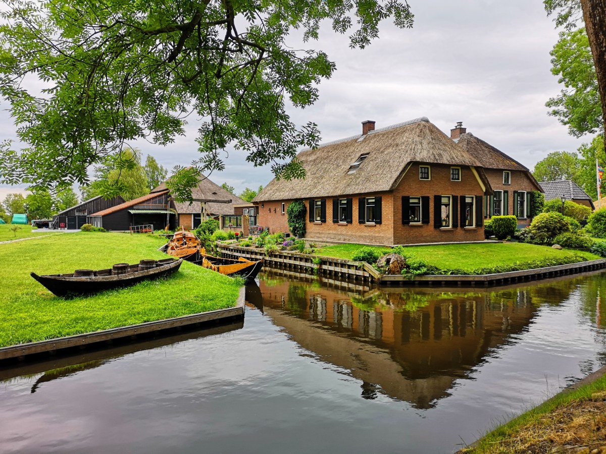
Camelback Farmhouse Architecture and Thatch Flammability
The architectural profile of Giethoorn is defined not by aesthetic whimsy, by the brutal necessities of survival on a sponge. The iconic Gieterse boerderij (Giethoorn farmhouse) is a structure engineered to float on waterlogged peat, characterized by its distinctive "camelback" (kameelrug) roofline. This asymmetry, where the ridge of the rear barn rises significantly higher than the living quarters, was never a stylistic choice. It was a functional mandate driven by the harvest. The rear section, the achterhuis, required immense vertical volume to store the winter's supply of hay and reeds, while the human inhabitants in the voorhuis huddled in smaller, lower spaces to conserve heat. The resulting silhouette, resembling the hump of a camel, dominates the village horizon, a physical graph of the priority placed on fuel and fodder over human comfort.
Beneath the thatch, the skeleton of these structures reveals a mastery of amphibious engineering. Traditional foundations of stone or concrete would sink into the deep peat. Instead, 18th and 19th-century builders used timber frames known as gebinten, resting on piles driven into the slightly firmer sand beneath the peat, or, on broad wooden rafts that distributed the weight across the unstable surface. The walls of the farmhouse are not load-bearing; they are curtains of brick or wood. The roof rests entirely on the internal timber skeleton. This design allows the building to shift and settle without collapsing, a necessary adaptation in a terrain where the ground level can fluctuate with the water table. When a Giethoorn farmhouse leans, it is rarely a sign of imminent failure, rather the structure breathing with the soil.
The roof itself is a massive blanket of local vegetation, primarily reed (Phragmites australis) harvested from the surrounding Weerribben-Wieden marshes. For centuries, this material was the only affordable roofing option for the peat diggers. It offers exceptional insulation, keeping the interior cool in summer and retaining warmth in winter. Yet, this organic efficiency comes with a deadly trade-off: the roof is a fuel pile waiting for a spark. The flammability of thatch has dictated the social and economic life of the village for three hundred years. In the 18th century, a "Red Rooster" (Rode Haan), local slang for a fire, meant total destruction. Once ignited, a traditional open-construction thatch roof draws oxygen from, creating a chimney effect that incinerates the structure in minutes. Historical records from the region indicate that entire clusters of farms were frequently wiped out when strong winds carried embers from one roof to the.
The mechanics of these fires are terrifyingly simple. The serious danger zone is the chimney penetration. In traditional construction, the thatch lies directly against the chimney masonry. Over time, the heat from the hearth transfers through the bricks to the dried reed. This process, known as pyrolysis, chemically alters the thatch, lowering its ignition temperature until it can spontaneously combust at temperatures as low as 200 degrees Celsius. Modern investigations show that nearly 90 percent of thatch fires originate not from external sparks, from this invisible heat transfer or from cracks in aging chimney flues. The romantic plume of woodsmoke rising from a Giethoorn cottage is, in technical terms, a continuous thermal assault on the building's primary structural defense.
By the late 20th century, the fire risk forced a revolution in roofing technology. The introduction of the schroefdak (screw roof) marked a pivot from agricultural tradition to modern safety compliance. In this system, the reed is screwed tightly onto a closed substrate of fire-resistant board, eliminating the air gap that feeds the flames. While a traditional open roof burns from both sides, a screw roof smolders only on the surface, allowing fire crews precious time to extinguish the blaze. Yet, this innovation created a visual schism. Purists that the screw roof absence the "breathing" quality and the soft, rounded aesthetics of the traditional method. The sharp, flat lines of a modern renovation frequently betray the age of the structure, signaling to the trained eye that the farmhouse has been converted from a working agricultural machine into a high-value residential asset.
The economics of thatch have shifted violently between 2000 and 2026. As Giethoorn transformed into a global tourist magnet, the demand for pristine, photogenic roofs outstripped the local supply of high-quality Kalenberg reed. Cheaper, more brittle reed imported from China and Turkey began to appear on local roofs, leading to a degradation in durability. Local reed cutters, guardians of a centuries-old guild, warn that these imports rot faster and are more susceptible to algae, requiring replacement every 25 years instead of the traditional 40. This material adulteration, combined with the intense humidity of the canal environment, has accelerated the decay of the village's architectural skin.
Insurance data from 2024 to 2026 reveals a emergency in the preservation of these camelback structures. Premiums for thatched homes in the Netherlands have skyrocketed, with insurers exiting the market entirely. A farmhouse with an open construction roof is virtually uninsurable without the installation of expensive suppression systems, such as exterior sprinkler cannons or chemical impregnation. The cost of maintaining the "village view" has become a luxury tax. Residents face annual premiums that can exceed 5, 000 euros, a figure that drives the gentrification of the village. Only the wealthy, frequently outsiders using the farms as vacation homes, can afford the upkeep and the insurance, turning the authentic architecture into a facade maintained for the benefit of tour boat operators.
The following table outlines the technical and economic between traditional and modern thatch systems in Giethoorn as of 2026:
Feature
Traditional Open Construction
Modern Screw Roof (Schroefdak)
Airflow
High (allows drying, feeds fire)
None (sealed, requires ventilation)
Fire Spread Speed
Rapid (5-10 minutes to total loss)
Slow (Surface charring only)
Insurance Status (2026)
High Risk / Uninsurable
Standard Residential Rates
Insulation Value (Rc)
Low (approx 1. 5)
High (approx 4. 0+)
Construction Cost
High Labor / Lower Material
High Material / High Labor
Climate change has further weaponized the thatch. The summers of the 2020s, characterized by prolonged droughts followed by intense rainfall, have stressed the reed. Dry reed becomes explosive; wet reed rots. The "Golden Reed" of the Weerribben, once the gold standard for durability, is struggling to adapt to these erratic pattern. In 2022 and 2025, regional safety regions issued "Code Red" warnings, prohibiting the use of wood stoves and outdoor fires during dry spells, freezing the hearths of Giethoorn. The village, famous for its water, fears the dryness of its own roofs.
The camelback farmhouse remains the protagonist of the Giethoorn narrative. It is a survivor of floods, peat extraction, and economic upheaval. Yet, its future is precarious. The structure that was designed to float on wet soil must survive the financial fires of the 21st century. The transition from functional farm to museum piece is nearly complete, the maintenance of that illusion requires a constant infusion of capital and chemistry. The thatch that tourists admire is no longer just a plant; it is a complex industrial product, treated, screwed, and insured against the very elements it was harvested from.
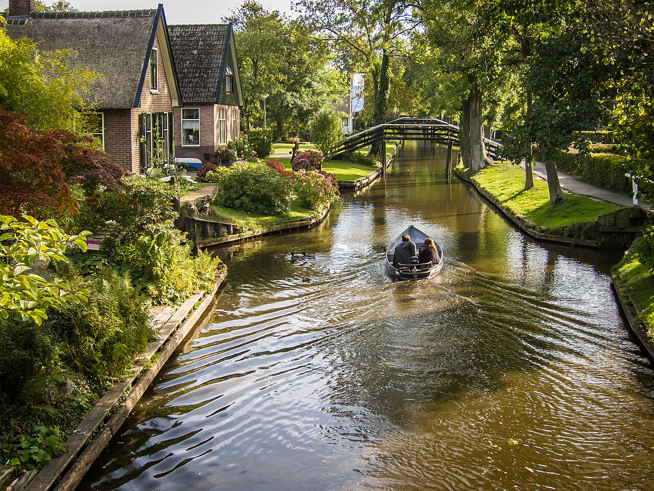
Punter Vessel Hydrodynamics and Propulsion
Storm Surge of 1825 and Topographical Shifts
The primary vehicle of the Giethoorn peat district, the Gieterse Punter, represents a specific engineering response to the constraints of shallow, narrow, and muddy waterways. Unlike the recreational vessels that clog the village canals in 2026, the original punter was a heavy-duty industrial platform. Historical specifications from the Wildeboer and Schreur shipyards, the last remaining custodians of this boat-building tradition, establish the standard dimensions of the Gieterse Punter at 6. 30 meters in length and 1. 45 meters in beam. The defining feature is its draft. With a hull depth of 15 to 20 centimeters unladen, the vessel could navigate the newly dug "trekgaten" (peat cuts) where water depth rarely exceeded one meter. This ultra-shallow draft was not a design choice for speed, a need for accessing the remote extraction zones of the Weerribben-Wieden.
Hydrodynamically, the punter operates on the principle of high form stability. The hull features a flat bottom (het vlak) constructed originally from solid oak, which transitions into angular, flared sides (boeisels) via a hard chine (knikspant). This box-like cross-section provides exceptional initial stability, a serious requirement for a vessel designed to transport shifting loads rather than static ballast. In the 18th and 19th centuries, these loads included wet peat, reed bundles, and livestock. The "Vee-punter" (cattle punter) variant was wide enough to transport cows to and from the marshy islands. The flat bottom allowed the boat to rest stable on the mud when water levels dropped or when the vessel was winched onto land, a maneuver impossible for round-bilged craft.
Propulsion in the pre-industrial era relied entirely on human biomechanics and wind. The primary method, "bomen" (punting), utilizes a long wooden pole (the punterboom) to push against the canal bed. Unlike the vertical pole technique seen in deep-water punting elsewhere, the Giethoorn method requires the operator to stand near the stern, planting the pole and walking forward or leaning heavily to generate thrust. The physics of this propulsion method dictate the vessel's stern shape; the Gieterse Punter has a small stern transom to accommodate the operator's stance. The "punterboom" also functions as a rudder. By manipulating the angle of the pole against the water's resistance and the canal bottom, a skilled operator can steer the vessel without a stern-mounted rudder, although a separate oak rudder with a characteristic "bird's head" tiller was frequently attached for sailing.
When wind power was available, the punter deployed a sprit sail (sprietzeil). The mast was stepped well forward, a configuration that maximized cargo space amidships compromised sailing balance. To counteract the vessel's tendency to drift sideways, a consequence of its flat bottom and absence of a keel, the punter employed leeboards (zwaarden). These fan-shaped oak boards were pivoted on the sides of the hull; the leeward board would be lowered into the water to provide lateral resistance, converting the wind's force into forward motion rather than leeway. This system allowed the shallow-draft vessels to traverse the open waters of the Beulakerwijde and Belterwijde lakes, which were notorious for short, steep chop that could swamp lesser boats.
The construction material of the punter fleet underwent a radical shift coinciding with the industrialization of the Netherlands. Until the early 20th century, oak was the only viable material, sourced from forests in the hinterland. yet, the maintenance load of wooden hulls in fresh water, constant tarring and caulking with moss, was high. By the mid-20th century, steel and later aluminum and polyester began to replace oak for commercial and utility vessels. The Wildeboer shipyard, founded by Thomas Vos around 1890, documents this transition. While the yard continues to build traditional oak punters for enthusiasts in 2026, the working fleet of the village transitioned to lower-maintenance materials decades ago. The shift to steel altered the hydrodynamic profile; steel punters were heavier, sitting lower in the water, which increased displacement and required more force to propel, eventually necessitating the adoption of internal combustion engines.
The introduction of the outboard motor in the mid-20th century fundamentally changed the canal hydrodynamics. The wash from propeller-driven craft eroded the soft peat banks far more aggressively than the slow-moving, pole-driven punters. This necessitated the reinforcement of canal banks with hardwood piling, a costly infrastructure project that continues to consume municipal budgets in Steenwijkerland. also, the noise of two-stroke engines disrupted the ecological quietude that was becoming Giethoorn's primary economic asset: tourism.
By 2026, the propulsion paradigm had shifted again, this time to electric power. The "fluisterboot" (whisper boat) is the dominant vessel type. Local bylaws and environmental regulations in the Weerribben-Wieden National Park have banned combustion engines for rental fleets, mandating electric propulsion. These modern vessels frequently mimic the visual lines of the traditional punter suffer from inferior hydrodynamics. rental boats are boxy, polyester constructs designed for maximum passenger capacity and stability for inexperienced tourists, rather than hydrodynamic efficiency. They plow through the water rather than cutting through it, relying on battery torque to overcome their high drag coefficients. In contrast, a traditional oak punter, with its raked and narrow entry, moves with minimal disturbance, a testament to a design evolved over centuries of manual labor.
The efficiency of the electric motors used in 2026 varies, most rental fleets use pod-drives limited to approximately 4 to 6 kilometers per hour. This speed limit is not a safety measure a hydrodynamic one; exceeding this speed in the narrow, shallow canals creates a bow wave that washes over the low freeboard of passing vessels and accelerates bank. The electric motors provide instant torque, which helps inexperienced pilots maneuver the heavy, flat-bottomed boats against the wind, they absence the nuanced control of the traditional quant pole. The art of "bomen" has largely from daily practice, preserved only by a small cadre of local traditionalists and the shipyard workers who understand that the Giethoorn punter was never just a boat, an extension of the laborer's body.
Table 4. 1: Comparative Specifications of Giethoorn Vessels (1850 vs. 2026)
Feature
Traditional Gieterse Punter (c. 1850)
Modern Electric Rental "Punter" (c. 2026)
Hull Material
Solid Oak (Eikenhout)
Polyester / Aluminum / Steel
Length
6. 30 meters
5. 50 , 6. 50 meters
Beam (Width)
1. 45 meters
1. 60 , 1. 80 meters (Widened for stability)
Draft (Unladen)
0. 15 meters
0. 25 , 0. 35 meters (Due to batteries)
Propulsion
Manual (Quant Pole) / Sail
Electric Pod Drive (Lead-acid or Li-ion)
Steering
Pole / Oak Rudder
Steel Rudder / Wheel Console
Primary Cargo
Peat, Cattle, Reeds, Hay
Tourists (4-8 passengers)
The survival of the traditional punter design is owed largely to the persistence of the Wildeboer and Schreur families. In an era where mass-produced sloops dominate the Dutch waterways, these yards maintain the specific skill set required to bend oak planks over fire to achieve the punter's characteristic flare. This process, known as "branden," requires precise temperature control to soften the lignin in the wood without charring it. A 1974 documentary by Gait Berk recorded the Schreur brothers constructing a punter using these methods, capturing a process where the hull shape is determined not by blueprints, by the tension of the wood and the eye of the builder. In 2026, this archival footage serves as a serious reference point for restoration projects, ensuring that the hydrodynamics of the 18th century are not lost to the conveniences of modern fiberglass molding.
The hydrodynamic interaction between the vessel and the canal bottom remains a defining characteristic of Giethoorn's nautical environment. In the shallowest sections, a phenomenon known as the "squat effect" increases the draft of the boat as speed increases, causing the flat bottom to suck closer to the mud. For the heavy electric rental boats, this increases drag significantly, draining batteries faster than predicted by open-water models. The traditional punter, being lighter and narrower, was less susceptible to this effect at working speeds. The shift to electric propulsion, while solving the noise and emission problems, has introduced a new variable: battery weight. A bank of lead-acid batteries adds significant mass to the hull, altering the center of and increasing the wetted surface area. This requires modern shipwrights to adjust the displacement calculations that held true for three centuries, redesigning the punter to carry a chemical power plant instead of a stack of dried peat.
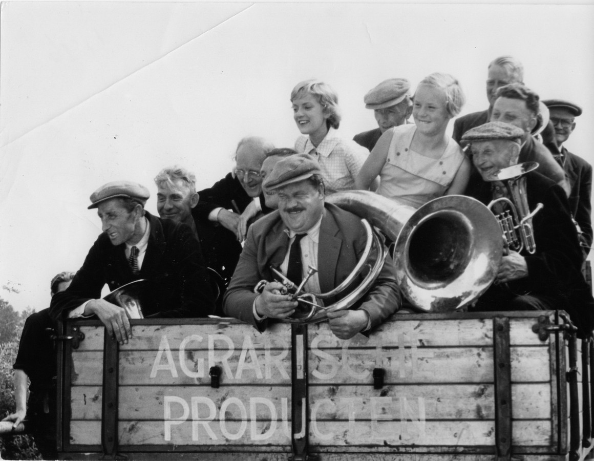
Economic Impact of Bert Haanstra’s Fanfare (1958)
The release of Bert Haanstra's comedy Fanfare in October 1958 marks the precise moment Giethoorn ceased to be a remote agricultural settlement and began its transformation into a global commercial product. Before this cinematic intervention, the village suffered from the economic vacuum left by the exhaustion of its peat reserves. The extraction industry that had defined the region since the 1700s had collapsed by the 1920s, leaving the inhabitants with a subsistence economy based on small- farming, reed cultivation, and fishing. The waterways were functional infrastructure, not scenic backdrops; they were the muddy, necessary transit routes for transporting manure, cattle, and hay in a hostile to wheeled vehicles.
Haanstra's film radically altered this trajectory. Viewed by 2. 6 million people, a figure representing nearly a quarter of the Dutch population at the time, Fanfare presented a sanitized, sun-drenched version of the village. It framed the canals as romantic avenues and the locals as quirky, harmonious rustics. The economic reaction was instantaneous. Dutch families, captivated by the imagery of a "village with no roads," flooded the narrow footpaths and waterways. The local economy, previously dependent on the grueling labor of peat dredging and reed cutting, pivoted almost overnight to service this influx. Farmers realized that transporting city dwellers in their flat-bottomed punts was significantly more profitable and less physically punishing than transporting cows.
The commercialization of the village identity is most visible in the branding of local establishments. The village café, originally named De Waaijer, was the primary meeting place for the film's fictional brass bands. Following the film's success, the owners renamed it Café Fanfare, a moniker it retains in 2026. This was not a tribute; it was a calculated business decision to monetize the cinematic association. The "punter," a vessel designed for heavy industrial haulage in shallow water, was reconfigured with benches and cushions. Boat building, a dying trade in the post-peat era, experienced a renaissance, not for industrial utility, to supply the growing fleet of rental craft required by the tourist trade.
The "Venice of the North" moniker, while in use prior to 1958, was solidified by the film's distribution. This branding strategy proved yet destructive. By the late 20th century, the domestic tourism sparked by Fanfare had metastasized into international mass tourism. The marketing narrative stripped the village of its industrial history, the scars of peat excavation, and sold it as a fairytale untouched by time. This erasure was profitable. By 2015, the village attracted 800, 000 visitors annually. By 2019, that number surpassed one million, a ratio of roughly 350 tourists for every permanent resident.
The arrival of the Chinese market in the 2010s, followed by visitors from the Middle East and the United States, shifted the economic from local sustenance to extraction by external capital. In 2026, the economic benefits of this tourism are unevenly distributed. While boat rental companies and hospitality groups thrive, the residential housing market has become dysfunctional. The demand for vacation rentals and investment properties has severed the link between local wages and housing costs. A standard farmhouse, once the dwelling of a peat laborer, commands a price that excludes the descendants of those laborers. The village center has become a museum, where the "residents" are frequently transient investors or wealthy retirees, and the "community" is a rotating cast of day-trippers.
This economic monoculture carries serious risks. The village is entirely dependent on the flow of global travelers. The COVID-19 pandemic demonstrated the fragility of this model, yet the post-pandemic rebound saw visitor numbers surge past previous records by 2024. The infrastructure, built on soft peat soil and designed for foot traffic and light boats, degrades under the pressure of millions of footsteps and the wash of electric rental boats. The municipality of Steenwijkerland has been forced to intervene, debating entry fees and restrictions on tour buses in 2025 to prevent total infrastructural failure. The "Fanfare Effect" saved Giethoorn from poverty in 1958, it also initiated a process of gentrification and commodification that threatens to erase the village's authentic social fabric by 2030.
The legacy of Fanfare is a dual-edged sword. It preserved the physical structure of the village, without the tourist revenue, the canals might have been filled in for roads as they were in other Dutch towns, it hollowed out the community. The "authentic" village life depicted in the film is a performance enacted for visitors. The cows that were famously transported by boat in the movie are gone from the village center, replaced by tourists navigating with smartphones. In 2026, Giethoorn exists in a state of paradox: it is economically strong socially fragile, a place where the primary industry is the sale of its own image.
De Wieden Wetlands and Subsidence Control
Camelback Farmhouse Architecture and Thatch Flammability
The geography of Giethoorn and the surrounding De Wieden wetlands is defined not by natural evolution, by a catastrophic failure of industrial planning. By the late 18th century, the peat extraction industry had compromised the structural integrity of the terrain. To maximize fuel production, excavators narrowed the setwallen, the strips of land left between peat cuts to dry the fuel, beyond safe limits. This greed rendered the delta defenseless against the elements. The reckoning arrived on the nights of November 21 and 22, 1776, when a violent northwestern storm surged inland. The weakened ribs of land collapsed, merging thousands of peat cuts into the massive, open lakes known today as the Beulakerwijde and Belterwijde. The village of Beulake, a settlement of peat cutters, was obliterated, its foundations permanently submerged under the water that attracts millions of tourists.
Following this disaster, the region entered a phase of aggressive hydrological engineering designed to impose order on the chaotic waters. The central method of this control is the A. F. Stroink pumping station (Gemaal A. F. Stroink), located at the edge of the Vollenhovermeer. Commissioned in 1919 and fully operational by 1920, this facility marked the transition from wind-powered drainage to industrial water management. Originally steam-powered, then converted to diesel and electric, the station possesses a discharge capacity of 3, 200 cubic meters per minute. For over a century, this machine has artificially maintained the water levels of the Northwest Overijssel boezem (storage basin), preventing the complete inundation of the remaining agricultural land while simultaneously facilitating the drainage that destroys the peat soil it aims to protect.
The drainage required for agriculture and habitation has triggered a slow-motion geological collapse known as subsidence. When peat soil is drained of water, it is exposed to oxygen, causing the organic matter to oxidize and decompose. This chemical reaction releases carbon dioxide into the atmosphere and causes the ground level to sink, a process termed inklinking. Historical data indicates that parts of the deep peat polders in the Kop van Overijssel have subsided at rates between 10 and 15 millimeters per year during the 20th century. This creates a vicious pattern: as the land sinks, water levels must be lowered further to keep fields dry, which in turn accelerates oxidation and further subsidence. By 2024, the peatlands of Overijssel were identified as a primary source of the Netherlands' non-industrial CO2 emissions, forcing a confrontation between preservationists and the agricultural sector.
Hydrological Management Eras in De Wieden (1750, 2026)
Time Period
Dominant Strategy
Physical Consequence
1750, 1825
Maximum Extraction
Collapse of land blocks; formation of Beulakerwijde lake.
Compartmentalization of nature (wet) and farming (dry).
2016, 2026
"Water en Bodem Sturend"
Rewetting efforts; conflict over raised water tables.
In the period between 2020 and 2026, the management of De Wieden shifted radically under the pressure of the national nitrogen (stikstof) emergency and climate accords. The Waterschap Drents Overijsselse Delta (Water Board) began implementing a policy where water and soil conditions dictate land use, reversing decades of "peil volgt functie" (water level follows function) doctrine. The 2024, 2025 "Wieden Fase 2" project exemplifies this pivot. Engineers are currently re-excavating silted-up peat holes to restart the process of terrestrialization (verlanding), creating new "trilveen" (quaking bog) habitats. These floating mats of vegetation are necessary for biodiversity require high, stable water levels that threaten adjacent farmland. The modern struggle is no longer against the storm surges of 1776, against the chemical disintegration of the ground itself.
The reintroduction of the otter in 2002 served as a biological metric for these hydrological changes. By 2026, the otter population in the Weerribben-Wieden had stabilized, signaling an improvement in water quality, yet the underlying instability remains. The artificial separation of water levels, high for the Natura 2000 protected wetlands and low for the surrounding dairy farms, requires constant mechanical intervention. Without the continuous operation of the Stroink pumping station and a network of smaller pumps, the differentiation between the tourist-friendly canals of Giethoorn and the submerged ruins of Beulake would, returning the entire region to a uniform, uninhabitable marsh.
Sino-Dutch Tourism Marketing Campaigns 2005, 2019
The transformation of Giethoorn from a quiet peat-harvesting settlement into a global brand was not an accidental byproduct of globalization; it was the result of a calculated, fifteen-year marketing offensive specifically targeting the People's Republic of China. Between 2005 and 2019, a coalition of local entrepreneurs and national tourism boards executed a strategy that repositioned the village of 2, 600 residents as a "must-see" icon for the rising Chinese middle class. This campaign relied on the systematic commodification of "Dutch tranquility," selling a curated image of pastoral silence to a demographic with rapid urbanization and industrial smog.
The architect of this pivot was Gabriella Esselbrugge, owner of the local hotel De Dames van de Jonge. In 2005, facing the seasonal stagnation of the local tourism economy, Esselbrugge identified China not as a source of volume, as a market seeking specific cultural validators. While Amsterdam focused on the Rijksmuseum and the Red Light District, Esselbrugge recognized that Chinese travelers, particularly the post-80s generation, sought "authentic" European rural experiences that contrasted with the density of Beijing or Shanghai. She initiated a series of solo trade missions to China, attending travel fairs and engaging directly with tour operators long before the national tourism board prioritized the region. Her method was precise: she adapted her hotel's operations to meet specific cultural expectations, installing noodle cookers in rooms and translating menus into Mandarin, creating a "China-ready" benchmark that other local businesses were forced to adopt to compete.
The campaign's turning point occurred in 2015, during Hasbro's global vote to select cities for the "Monopoly Here &: World Edition" board game. While major metropolises like London and New York relied on passive recognition, Giethoorn launched a digital mobilization campaign that leveraged the sheer of Chinese social media. Local marketers and Dutch tourism officials encouraged Chinese netizens to vote for the village. The result was a statistical anomaly: Giethoorn, a hamlet with zero traffic lights and fewer than 3, 000 inhabitants, received enough votes to secure a brown property square on the global board, beating out Madrid and Moscow. This victory was not a reflection of organic global popularity a demonstration of the organized voting power of the Chinese internet. The win granted Giethoorn instant legitimacy in the Chinese market, validating it as a "world-class" destination alongside Paris and Sydney.
Following the Monopoly victory, the Netherlands Board of Tourism & Conventions (NBTC) integrated Giethoorn into its "HollandCity" strategy. This national directive aimed to alleviate the crushing tourist density in Amsterdam by redistributing visitors to "lesser-known" regions. Giethoorn became the primary beneficiary, and victim, of this policy. The NBTC and local promoters marketed the village under the moniker "The Venice of the North," a label that appeared in thousands of Weibo posts and WeChat travel guides. The branding was highly; data from 2015 showed that the number of Chinese visitors to the Netherlands jumped by 21 percent, with Giethoorn capturing a disproportionate share of this traffic. By 2016, it was estimated that 150, 000 to 200, 000 Chinese tourists visited the village annually, a figure that would nearly double by 2019.
The marketing narrative sold to Chinese tour operators emphasized a "fairytale" existence that divorced the village from its functional reality. Promotional materials depicted empty canals, green lawns, and blue skies, imagery that resonated deeply with urban Chinese residents dealing with severe air pollution levels in 2010s China. This romanticized packaging created a dissonance upon arrival. The "silence" promised in brochures was frequently broken by the arrival of fifty-seat coaches. To accommodate the influx, the village infrastructure underwent a rapid linguistic and logistical overhaul. Bus line 70, connecting the Steenwijk train station to the village, began displaying destination signs in Chinese characters. Local boat rental companies, previously family-run operations serving Dutch day-trippers, scaled up fleets to handle groups of hundreds, accepting payments via Alipay and WeChat Pay.
The cultural impact of this marketing push was documented in the 2015 film Ni Hao Holland, which captured the friction between the marketed fantasy and the operational reality. The film showed Chinese tourists navigating the village with specific expectations of "Dutch light" and "open space," frequently leading to trespassing incidents where visitors entered private gardens, believing the entire village was a staged open-air museum. This behavior was not malicious a direct consequence of the marketing strategy, which presented Giethoorn as a consumable product rather than a living community. The "Village with No Roads" slogan, used extensively in Chinese travel blogs, reinforced the idea of a theme park designed for pedestrian exploration.
By 2019, the success of the Sino-Dutch marketing campaigns had produced metrics that sustainable limits. The village recorded approximately 972, 270 day-visitors that year. With a stable population of roughly 2, 600, this resulted in a ratio of nearly 375 tourists per resident, a density far exceeding that of Venice or Barcelona. The economic injection was substantial; Chinese tourists were recorded as high spenders, averaging over €1, 250 per trip to the Netherlands, with directed toward high-end boat rentals and hospitality in the region. Yet, the demographic shift was absolute. In the span of 14 years, the primary language heard on the canals shifted from Dutch and German to Mandarin, a direct testament to the efficacy of the targeted campaigns launched by Esselbrugge and the NBTC.
Visitor Growth and Demographics: Giethoorn & National Context (2012, 2019)
Year
Total Annual Visitors (Est.)
Chinese Visitors to NL (NBTC Data)
Key Marketing Milestone
2012
~400, 000
~180, 000
Early trade missions by local entrepreneurs.
2014
~600, 000
~250, 000
"HollandCity" strategy implementation begins.
2015
~750, 000
300, 000 (+21% YoY)
Giethoorn wins Monopoly World Edition vote.
2017
~850, 000
~350, 000
Widespread adoption of Alipay/WeChat Pay locally.
2019
972, 270
~380, 000
Peak volume; "Overtourism" declared a emergency.
The marketing also used "Key Opinion Leaders" (KOLs) on Chinese social platforms to sustain interest. Unlike Western marketing which relies on search engine optimization, the Giethoorn strategy focused on peer-to-peer validation within the "Great Firewall." Influencers posted carefully framed photos of the thatched-roof farmhouses, omitting the queues of boats waiting to navigate the narrow canals. This digital feedback loop ensured that even as the physical experience degraded due to overcrowding, the digital reputation of Giethoorn in China remained pristine. The village became a status symbol; a selfie on a "punter" boat proved one had the means to travel to Europe's most "exclusive" rural retreat.
This era of hyper-growth concluded abruptly with the global travel freeze of 2020, yet the physical and economic of Giethoorn had been permanently altered. The marketing campaigns of 2005, 2019 did not attract visitors; they restructured the local economy to serve a specific geopolitical market. The boat shops, the hotels, and the souvenir stands had all pivoted their business models to align with the p
Visitor Density and Infrastructure Strain 2015, 2023
Punter Vessel Hydrodynamics and Propulsion
By 2015, Giethoorn had ceased to be a Dutch village; it had transformed into a global commodity. The marketing narrative, aggressively promoting the settlement as the "Venice of the North," succeeded with devastating efficiency. Between 2015 and 2019, the village experienced an exponential surge in visitor numbers that shattered its infrastructural capacity. The primary driver of this influx was a targeted campaign aimed at the Chinese market. In 2015, local hoteliers reported that two-thirds of their guests hailed from China, a demographic that spent an average of €1, 250 per visit, nearly double the €700 average of other international tourists. This economic incentive drove a relentless expansion of tourism services, prioritizing high-volume day-trippers over the preservation of residential tranquility.
The year 2019 marked the apex of this pre-pandemic saturation. Data from that year reveals a visitor-to-resident ratio of 351: 1. For a population of approximately 2, 600 to 2, 800 people, the village absorbed nearly one million visitors annually. The physical toll on the delicate peat-based infrastructure was immediate and severe. The "punter" boats, once the silent workhorses of peat transport, were replaced by fleets of electric rental boats piloted by inexperienced tourists. The narrow canals, designed for low-volume agricultural traffic, became gridlocked aquatic highways. Residents reported frequent collisions damaging the wooden banks and historic, necessitating emergency repairs in May 2019 to prevent structural failure.
The social fabric of Giethoorn disintegrated under this pressure. The village center, particularly the Binnenpad, ceased to function as a residential zone. In September 2019, a coalition of residents formally petitioned the municipal council, citing "nuisance perpetrators" who trespassed into private gardens, peered through windows, and blocked emergency service access. The commodification of the village turned private homes into backdrops for selfies; residents described the sensation of living in an open-air museum where their privacy was the price of admission. Real estate shifted accordingly, with long-term housing stock increasingly converted into vacation rentals or sold to investors capitalizing on the "theme park" economy.
The arrival of the COVID-19 pandemic in early 2020 imposed an abrupt, involuntary moratorium on this trajectory. Visitor numbers for the Netherlands plummeted from over 20 million in 2019 to roughly 7. 3 million in 2020. For Giethoorn, the silence was absolute short-lived. While international travel collapsed, the village became a magnet for domestic tourists seeking escape within Dutch borders. By 2021, the demographic mix had shifted, yet the pressure on the physical remained. The "peace" of the lockdown era was an economic shock to the businesses that had pivoted entirely to serve the Asian market, revealing the fragility of a monoculture economy dependent on long-haul travel.
The post-pandemic rebound in 2022 and 2023 demonstrated that the pause had not led to a strategic rethink, rather a pent-up demand for the same extractive tourism model. By 2023, international visitor numbers to the Netherlands had surpassed pre-pandemic levels, reaching 20. 3 million. Chinese tourism, while slower to return due to lingering travel restrictions, began a sharp vertical ascent, with 177, 000 visitors recorded in 2023, more than double the previous year. The infrastructure, unexpanded and aging, faced renewed. The narrow footpaths and, already weakened by the 2015, 2019 surge, were subjected to a new wave of foot traffic that exceeded the carrying capacity of the boggy soil foundation.
Visitor Density and Economic Metrics (2015, 2023)
Metric
2015 Data
2019 Peak
2023 Status
Annual Visitors (Est.)
~800, 000
~1, 000, 000
>1, 000, 000 (Projected)
Visitor-to-Resident Ratio
285: 1
351: 1
Trending toward 400: 1
Primary Demographics
Chinese, German
Chinese (67% of hotel stays)
Domestic, returning Asian market
Infrastructure Status
serious Failure ( repairs)
Saturation
By late 2023, the "Venice" branding had cemented a reality where the village's identity was defined externally. The municipality of Steenwijkerland faced an impossible paradox: the economic engine of the region was simultaneously the agent of its physical destruction. Proposals to cap visitor numbers or ban day-trippers were floated frequently diluted by commercial interests. The result was a "museumification" of Giethoorn, where the authentic peat-mining history discussed in earlier sections was sanitized and packaged for mass consumption, obscuring the grim industrial reality of the 18th and 19th centuries beneath a veneer of pastoral romance.
Commercial Real Estate Consolidation 2020, 2026
The silence that fell over Giethoorn in March 2020 was not a restoration of nature. It was a vacuum that preceded a hostile takeover. When the COVID-19 pandemic severed the flow of international tourism, the village's economy, hyper-specialized for extraction since the peat-digging era, suffered an immediate cardiac arrest. Local families who had converted their farmhouses into Bed & Breakfasts faced bankruptcy. The canals, empty of the whisper boats that clog them bumper-to-bumper, revealed the fragility of a monoculture economy. Yet this distress did not lead to a return to residential normalcy. It signaled a clearance sale for high-capital investors who viewed the village not as a community, as a distressed asset class with guaranteed long-term yield. Between 2021 and 2023, a quiet transfer of deeds took place along the Binnenpad and Zuiderpad. While the media focused on the return of tourists, the ownership structure of the village underwent a radical consolidation. Small operators, unable to weather two years of zero revenue, sold their licenses and properties to larger hospitality conglomerates and real estate portfolios. The "Monopoly" edition featuring Giethoorn, released in 2015, became a grim prophecy for the 2020s. of entities began to control the vertical integration of the tourist experience: the parking lots, the boat rentals, the restaurants, and the short-term accommodation. The recovery of 2024 shattered all previous records. Visitor numbers surged past the one-million mark again, yet the revenue capture had shifted. In 2019, of tourist spending circulated among dozens of independent families. By 2025, that capital flowed increasingly into the accounts of limited liability companies and holding firms. The ratio of tourists to residents hit extreme levels, with approximately 350 visitors for every permanent inhabitant. The village of 2, 880 people functions as a theme park where the "cast members" are the remaining residents trying to sleep while tourists peer through their windows.
Giethoorn: The Displacement Metric (2020, 2026)
Year
Annual Visitors
Permanent Residents
Economic Phase
2020
~300, 000 (Est.)
2, 785
Market Collapse / Distressed Assets
2022
~800, 000
2, 880
Acquisition by Private Capital
2024
1, 100, 000+
2, 890
Corporate Standardization
2026
1, 250, 000 (Proj.)
2, 880
Full Commercial Consolidation
Policy decisions made in The Hague accelerated this corporate solidification in 2025 and 2026. The Dutch government introduced a new tax regime for Box 3 (assets and investments) and raised the Value Added Tax (VAT) on accommodation from 9% to 21% January 1, 2026. These measures were intended to cool the overheated national housing market. In Giethoorn, they had the opposite effect on local livability. Small- owners of a single holiday cottage found the new tax load untenable. They sold out. The buyers were inevitably larger investment vehicles capable of absorbing the VAT hike through volume and higher pricing power. The "uitponden" trend seen elsewhere in the Netherlands, selling rental units to owner-occupiers, did not materialize here. Instead, residential homes were permanently removed from the housing stock and converted into high-yield commercial lodging units managed by professional agencies. The narrative of "Chinese ownership" frequently in the 2010s evolved into a more complex reality by 2026. While Chinese tourism remains a serious revenue stream, the ownership of the physical assets is largely domestic Dutch capital and European private equity. These investors have optimized the village for high-throughput tourism. The "Venice of the North" is managed with the efficiency of a logistics hub. Boat rentals are digitized. Walking routes are engineered to maximize retail exposure. The authenticity of the peat-digger's cottage is preserved only as a facade for a high-margin rental product. This era represents the final phase of the enclosure movement that began three centuries ago. In the 1700s, the land was stripped of peat for fuel. In the 2020s, the village is stripped of privacy for entertainment. The residents of 2026 occupy a strange limbo. They own the land, yet they do not own the silence. The commercial consolidation has made Giethoorn one of the most profitable square kilometers in Overijssel, that profitability requires the total commodification of the living environment. The village has not just recovered from the pandemic; it has been re-engineered as a commercial campus where residency is a secondary concern to the daily extraction of tourist euros.
Noise Pollution and Canal Traffic Regulation
Economic Impact of Bert Haanstra’s Fanfare (1958)
The acoustic history of Giethoorn is a record of industrial silence giving way to recreational cacophony. Between 1700 and 1900, the primary sound on the village canals was the rhythmic thud of the boom, the wooden pole used to propel the traditional punter boats. These flat-bottomed oak vessels, designed specifically for the shallow, peat-dredged waterways, operated without engines. Traffic was strictly functional: farmers transporting cattle to island pastures, peat cutters moving "black gold" to transit hubs, and residents attending church or funerals. The silence was not a luxury; it was a byproduct of a labor-intensive economy where wind and muscle provided the only propulsion.
The introduction of the internal combustion engine in the early 20th century disrupted this equilibrium, yet the shallow draft of the canals limited the adoption of heavy motorized barges. The true acoustic shift arrived not with industry, with the camera lens. Following the release of Bert Haanstra's 1958 film Fanfare, the village transitioned from a peat colony to a tourist curiosity. By the 1970s, the roar of two-stroke outboard motors began to the banks (walbeschoeiing) and the patience of the 2, 600 residents. The vibration and wake from these engines accelerated the collapse of the fragile peat soil banks, forcing the Water Board to intervene.
In response to the ecological damage and noise complaints, Giethoorn became a pioneer in the mandatory adoption of electric propulsion. The "Quality Impulse" regulations of the 1990s and 2000s phased out combustion engines for rental fleets, mandating the use of the fluisterboot (whisper boat). These vessels use silent electric motors, theoretically restoring the village's auditory peace. Data from the Municipality of Steenwijkerland indicates that by 2020, over 95% of the rental fleet operated on electric power. Yet, the noise problem did not; it mutated. The mechanical chug of diesel engines was replaced by the social noise of mass tourism.
Evolution of Canal Traffic and Acoustic Signatures (1800, 2026)
Era
Dominant Vessel
Propulsion Method
Primary Noise Source
Traffic Function
1800, 1900
Gieterse Punter
Poling (Boom) / Sail
Water displacement, livestock
Peat extraction, Agriculture
1920, 1980
Motorized Punter / Vlet
Petrol/Diesel Outboard
Engine combustion (80+ dB)
Local transport, Early tourism
1990, 2015
Early Whisper Boat
Lead-Acid Electric
Motor hum, water wash
Domestic tourism
2016, 2026
Rental Sloop / E-Punt
Lithium-Ion Electric
Human voices, hull collisions
Global mass tourism
The turning point for canal congestion occurred in 2015, when Giethoorn secured a spot on the international Monopoly board. This marketing victory catalyzed an explosion in visitor numbers, particularly from Asian markets. By 2019, the village of roughly 2, 800 inhabitants received an estimated one million visitors annually. The canals, originally dug to the width of a single peat barge, became gridlocked. In high season, the village center functions as a continuous, bumper-to-bumper procession of novice skippers. The silence of the electric engines is negated by the sheer volume of hulls colliding and tourists shouting instructions across the water. Residents report that on peak days, the noise level from the canals exceeds 70 decibels, comparable to a busy roadside, solely from human vocalization and fiberglass impacts.
To manage this density, the municipality implemented strict traffic control measures that mirror urban roadway systems. A one-way traffic regulation is enforced on the main village canal (Dorpsgracht) to prevent head-on collisions that previously paralyzed the waterway for hours. Signage indicating "One Way" and "No Entry" is planted directly into the canal beds. Even with these controls, the volume of unauthorized rentals remains a point of contention. In 2024, the municipality recorded 26 traffic accidents in the borough, a statistic that blends road and water incidents, reflecting the chaotic interface where cyclists, pedestrians, and boats converge at the 176.
By 2025, the regulatory framework shifted from management to containment. The formation of "Giethoorn Village Partners," a coalition of local entrepreneurs, signaled a move toward self-regulation to stave off harsher government caps. This group aims to distribute visitors across a wider geographic area, pushing traffic out of the central "red zone" and into the wider lakes of the Weerribben-Wieden National Park. Current 2026 mandates restrict the issuance of new rental licenses, capping the commercial fleet. The village operates under a "Green Venice" model: strict environmental zones where only emission-free vessels are permitted, and a de facto limit on the number of hulls allowed in the water simultaneously. The punter, once the workhorse of the peat trade, has been relegated to a historical artifact, visible mostly in museum displays or piloted by the few remaining traditionalists who refuse to mount an electric pod on their stern.
Ice Skating Tradition and Winter Economy
The popular image of Giethoorn as a "Venice of the North" frequently relies on summer photography: verdant canals, flower-decked, and sunlight reflecting off the water. Yet, for the majority of the village's history between 1700 and 1950, winter defined the economic and logistical reality of the region. During the 18th and 19th centuries, the freezing of the canals was not a recreational event a serious infrastructural transformation. In a settlement devoid of paved roads, where the punter (a narrow, flat-bottomed boat) was the primary vehicle, a hard freeze meant the suspension of water transport. The ice became the road. For the peat diggers and reed cutters of the 1700s, the transition from water to ice dictated the rhythm of survival.
Historical records from the province of Overijssel indicate that between 1750 and 1850, the canals of Giethoorn were frozen for an average of 40 to 60 days annually. During these periods, the prik (the long wooden pole used to propel boats) was traded for bone or iron skates. This was not leisure; it was the only method to move goods. Farmers and laborers used sleds to transport peat, milk, and livestock across the frozen waterways. The isolation of the village, enforced by the surrounding swamp, was paradoxically broken by the ice, which allowed faster travel to markets in Steenwijk or Meppel than the slow, winding boat journeys of summer.
The winter economy of Giethoorn has historically relied on the harvest of Phragmites australis, or common reed. This industry, important to the village since the decline of peat extraction in the late 19th century, operates on a counter-seasonal pattern. The harvest window opens in December and closes in April. For the reed cutters of the 19th and early 20th centuries, a harsh winter was a blessing. When the "drowning land" of the Weerribben-Wieden nature reserve froze solid, cutters could access deep fenlands on foot or with sleds to harvest the reed used for thatching roofs across the Netherlands. A mild winter, characterized by mud and rain, made the marshland inaccessible and the work treacherous. The economic stability of Giethoorn's families frequently hinged on the thickness of the ice.
By the mid-20th century, as road infrastructure improved in the surrounding region, the need of ice transport faded, replaced by a cultural tradition of competitive and recreational skating. The Overijsselse Merentocht (Overijssel Lakes Tour), a skating marathon comparable to Friesland's famous Elfstedentocht, became a defining event for the village. The route, frequently exceeding 50 kilometers, threaded through the canals of Giethoorn, the Beulakerwijde, and the Belterwijde. The winter of 1963 remains the benchmark for this era. Known as "The Hell of '63," temperatures plummeted to -21°C, and the ice thickened to over 50 centimeters. During this winter, Giethoorn was landlocked by snow connected to the rest of the Netherlands by a vast network of skaters. The village transformed into a checkpoint for endurance athletes, a role that cemented its reputation as a winter destination for Dutch nationals.
The 21st century has introduced a sharp decline in this tradition, driven by measurable climatic shifts. Data from the Royal Netherlands Meteorological Institute (KNMI) demonstrates a clear downward trend in "ice days" (days where the maximum temperature remains 0°C) in the region. Between 1901 and 1930, the De Bilt station (a proxy for central Netherlands weather) recorded an average of 13 ice days per year. By the 1991, 2020 period, this average dropped to 6 days. For Giethoorn, this reduction is existential for the skating tourism sector. The canals, which are shallow and prone to quick freezing, still form ice, the deep lakes required for the longer tours rarely freeze safely. The Overijsselse Merentocht has not been held in decades, forcing the village to adapt its winter economic model.
The following table illustrates the decline in viable skating conditions and the simultaneous rise in winter tourism unrelated to ice, marking the economic shift from 1950 to 2025.
Decade
Avg. Ice Days/Year (Est.)
Major Skating Tours Hosted
Primary Winter Economic Driver
1950-1959
12
Frequent
Reed Cultivation / Local Transport
1980-1989
8
Occasional
Domestic Skating Tourism
2010-2019
3
None
International Bus Tours (Non-Skating)
2020-2026
<2
None
Year-Round Global Tourism / Walking Tours
In the absence of reliable ice, Giethoorn has pivoted toward a new form of winter economy, heavily influenced by international tourism, particularly from China and Southeast Asia. Unlike Dutch visitors, who historically avoided the village in winter unless there was ice, international tour groups visit year-round. By 2019, the village of roughly 2, 600 residents received an estimated 1 million visitors annually, with arriving in the "off-peak" months. This influx has decoupled the village's winter revenue from the weather. Souvenir shops, boat rentals ( equipped with covered, heated vessels), and restaurants remain open to serve tourists who come to see the "village with no roads," regardless of whether the canals are frozen or fluid.
The winter of 2025, 2026 exemplified this new reality. While skating enthusiasts waited in vain for a deep freeze, the village streets remained active. The reed harvest continued, mechanized and less dependent on ice, though the wet soil made the work arduous. The silence of the 18th-century winter, where a frozen canal meant isolation, is gone. It has been replaced by the hum of electric boat motors and the steady foot traffic of global travelers. The ice, once a highway for survival, is a rare novelty, appearing only briefly before melting into the gray water of the modern climate.
Preservation Zoning and Resident Displacement Data
The transformation of Giethoorn from a labor camp for peat extraction into a globally marketed open-air museum was cemented not by natural evolution, by bureaucratic intervention. On March 25, 1985, the Dutch government officially the village a Beschermd Dorpsgezicht (Protected Village View). This zoning classification, intended to preserve the unique architectural character of the peat-colony structures, froze the physical appearance of the settlement in the late 19th century. While this legislation succeeded in preventing modern high-rises or asphalt roads from destroying the historic grid, it inadvertently created a financial stranglehold on the indigenous population. The preservation orders mandated strict adherence to traditional building methods, specifically the maintenance of camel-back and thatched roofs, prohibiting cheaper modern alternatives.
For the descendants of the original peat cutters, this "museumification" turned their family homes into financial liabilities. The cost of maintaining a traditional reed roof in 2024 averaged between €25 and €55 per square meter for simple cleaning, with full replacement costs soaring to approximately €95 per square meter. A typical farmhouse roof requires renovation every 30 to 40 years, a capital expense that frequently exceeds €20, 000. Insurance premiums for these structures are also significantly higher due to fire risk. These mandated costs, paired with the restrictions on expanding or modernizing interiors, forced lower-income residents to sell their properties to wealthier outsiders who valued the aesthetic over the utility.
The demographic displacement accelerated violently between 2010 and 2026. As the "Venice of the North" marketing campaign went viral in Asia and the Middle East, the village ceased to be a functional community and became a commodity. By 2019, the village of approximately 2, 600 residents received over one million tourists annually. By 2025, visitor numbers surpassed 2 million, creating a ratio of roughly 714 tourists for every permanent resident. This influx distorted the local economy entirely. Basic services like butchers, bakeries, and schools struggled to survive as commercial space was cannibalized by souvenir shops, boat rental agencies, and vacation rentals.
Real estate data from 2020 to 2026 exposes the extent of this gentrification. Investors, recognizing the lucrative chance of short-term rentals, began purchasing residential properties at premiums that locals could not match. While the national average home price in the Netherlands hovered around €480, 000 in 2025, properties in the historic core of Giethoorn frequently commanded prices exceeding €1 million. The introduction of the Wet betaalbare huur (Affordable Rent Act) in July 2024, designed to curb exorbitant rents, paradoxically worsened the situation in heritage zones. Investors, facing capped rental returns, began offloading properties, yet the listing prices remained inaccessible to the local working class, resulting in a transfer of ownership to wealthy second-home buyers rather than young families.
Table 12. 1: The Giethoorn Displacement Index (1970, 2026)
Metric
1970 (Pre-Tourism Boom)
2000 (Early Conservation)
2026 (Hyper-Tourism Era)
Primary Economic Driver
Agriculture / Reed Cultivation
Domestic Tourism
Global Mass Tourism / Real Estate Speculation
Annual Visitor Count
< 50, 000 (Est.)
~200, 000
> 2, 000, 000
Housing Function
Primary Residence
Mixed Use
Investment Vehicle / Vacation Rental
Roof Maintenance Cost (Inflation Adj.)
Low (Local Labor/Materials)
Moderate
High (Specialized Contract Labor)
Resident Demographics
Generational Families
Aging Local Population
Transient / Wealthy Retirees / Absentees
The "Toekomstvisie Giethoorn" (Future Vision), a municipal strategy document released in February 2025, acknowledged that the "balance" between livability and economy had been shattered. Yet, the report offered few concrete method to reverse the damage. The village suffers from a "hollow core" phenomenon: during the winter months, when tourist numbers dip, the historic center is dark and lifeless because a significant percentage of the housing stock sits empty, owned by investors or used only as summer retreats. The social cohesion that defined the peat-cutting era, where neighbors relied on each other for survival against the water, has been replaced by a transient population of strangers passing through a preserved stage set.
This displacement is the final stage of the peat extraction pattern. In the 1700s, the land was physically consumed for fuel; in the 2000s, the community was consumed for entertainment. The zoning laws that were designed to save Giethoorn ensured that only the shell remains, while the living soul of the village was priced out, regulated into obedience, and replaced by a ticketed experience.
Why it matters: The traditional "Taiwan Silicon Semiconductor Shield" is no longer effective in deterring Chinese aggression. A shift in U.S. policy towards onshoring semiconductor production marks a…
What do we know about Peat Excavation and Artificial Waterways?
The serene waterways of Giethoorn, frequently romanticized in 2026 as a pastoral idyll, are in reality the flooded scars of industrial extraction. Between 1700 and 1850, this region functioned as a massive fuel mine.
What do we know about Storm Surge of and Topographical Shifts?
The topography of Giethoorn in 2026 is defined not by natural evolution, by a singular catastrophic event that occurred two centuries prior. On February 3, 1825, a massive storm surge from the Zuiderzee collided with the weakened, hollowed-out terrain of northwest Overijssel.
What do we know about Camelback Farmhouse Architecture and Thatch Flammability?
The architectural profile of Giethoorn is defined not by aesthetic whimsy, by the brutal necessities of survival on a sponge. The iconic Gieterse boerderij (Giethoorn farmhouse) is a structure engineered to float on waterlogged peat, characterized by its distinctive "camelback" (kameelrug) roofline.
What do we know about Punter Vessel Hydrodynamics and Propulsion?
The primary vehicle of the Giethoorn peat district, the Gieterse Punter, represents a specific engineering response to the constraints of shallow, narrow, and muddy waterways. Unlike the recreational vessels that clog the village canals in 2026, the original punter was a heavy-duty industrial platform.
What do we know about Economic Impact of Bert Haanstra’s Fanfare?
The release of Bert Haanstra's comedy Fanfare in October 1958 marks the precise moment Giethoorn ceased to be a remote agricultural settlement and began its transformation into a global commercial product. Before this cinematic intervention, the village suffered from the economic vacuum left by the exhaustion of its peat reserves.
What do we know about De Wieden Wetlands and Subsidence Control?
The geography of Giethoorn and the surrounding De Wieden wetlands is defined not by natural evolution, by a catastrophic failure of industrial planning. By the late 18th century, the peat extraction industry had compromised the structural integrity of the terrain.
What do we know about Sino-Dutch Tourism Marketing Campaigns?
The transformation of Giethoorn from a quiet peat-harvesting settlement into a global brand was not an accidental byproduct of globalization; it was the result of a calculated, fifteen-year marketing offensive specifically targeting the People's Republic of China. Between 2005 and 2019, a coalition of local entrepreneurs and national tourism boards executed a strategy that repositioned the village of 2, 600 residents as a "must-see" icon for the rising Chinese middle class.
What do we know about Visitor Density and Infrastructure Strain?
By 2015, Giethoorn had ceased to be a Dutch village; it had transformed into a global commodity. The marketing narrative, aggressively promoting the settlement as the "Venice of the North," succeeded with devastating efficiency.
What do we know about Commercial Real Estate Consolidation?
The silence that fell over Giethoorn in March 2020 was not a restoration of nature. It was a vacuum that preceded a hostile takeover.
What do we know about Noise Pollution and Canal Traffic Regulation?
The acoustic history of Giethoorn is a record of industrial silence giving way to recreational cacophony. Between 1700 and 1900, the primary sound on the village canals was the rhythmic thud of the boom, the wooden pole used to propel the traditional punter boats.
What do we know about Ice Skating Tradition and Winter Economy?
The popular image of Giethoorn as a "Venice of the North" frequently relies on summer photography: verdant canals, flower-decked, and sunlight reflecting off the water. Yet, for the majority of the village's history between 1700 and 1950, winter defined the economic and logistical reality of the region.
What do we know about Preservation Zoning and Resident Displacement Data?
The transformation of Giethoorn from a labor camp for peat extraction into a globally marketed open-air museum was cemented not by natural evolution, by bureaucratic intervention. On March 25, 1985, the Dutch government officially the village a Beschermd Dorpsgezicht (Protected Village View).
Why it matters: Healthcare disparities persist in the American healthcare system, with significant gaps in outcomes between White and Black patients. Racial identity remains a strong predictor of…
Why it matters: Belgian federal police conducted a coordinated raid targeting Chinese influence operations in Brussels and Wallonia. Authorities seized evidence implicating Huawei in alleged corruption, forgery, and…
Why it matters: Provincial and municipal green bonds saw a surge in late 2025, attracting investors seeking high yields amidst a broader corporate slowdown. The "Green Rush Development"…
Why it matters: Reported heat stress at work has surged by 17% globally, posing significant challenges for workers in sectors like agriculture and construction. Despite the increasing risks,…
Why it matters: Evidence shows that large-scale donors gain privileged access to political figures and decision-making platforms, potentially influencing policy decisions. Philanthropic contributions can shape public opinion and…
Why it matters: The explosion of online DIY home renovation content has led to a surge in amateur builders and decorators. Social media platforms often glamorize DIY projects…
Get updates on this place
Get verified alerts when this file is updated (verification required).