Verified Against Public And Audited RecordsLast Updated On: 2026-03-04
Reading time: ~46 min
File ID: EHGN-PLACE-35408
Investigative Bio of Hallstatt
Geological Constraints and Lake Hallstatt Topography
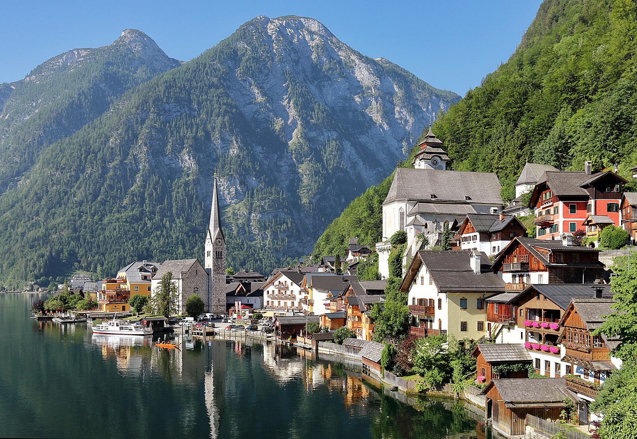
Hallstatt exists in a state of geological confinement. The settlement is not situated near a mountain; it is wedged into a precarious fracture zone where the Northern Calcareous Alps collide with the deep waters of the Hallstätter See. The town's physical footprint is dictated by two immutable forces: the unstable tectonic mélange of the salt-bearing mountain above and the bathymetric drop-off of the lake. For over three centuries, from 1700 to the present day, this topography has acted as both a and a prison, defining every aspect of urban development, transport logistics, and hazard management.
The dominant geological feature is the Haselgebirge formation. This is not a solid, monolithic rock face a chaotic, brecciated mass composed of halite (salt), clay, anhydrite, and mudstone. Formed during the Permian period and violently deformed during the Alpine orogeny, the Haselgebirge is mechanically weak and ductile. It behaves like a slow-moving fluid over geological timescales. This instability presents a constant engineering nightmare. The salt body, which rises steeply behind the market square, does not support heavy infrastructure easily. The ground is prone to subsidence and creep, a reality that miners have documented since the Bronze Age and that modern civil engineers continue to battle in 2026. The mountain is a "tectonic mélange," a mixture of rocks sheared and ground together, meaning the town rests on a slope that is geologically designed to slide.
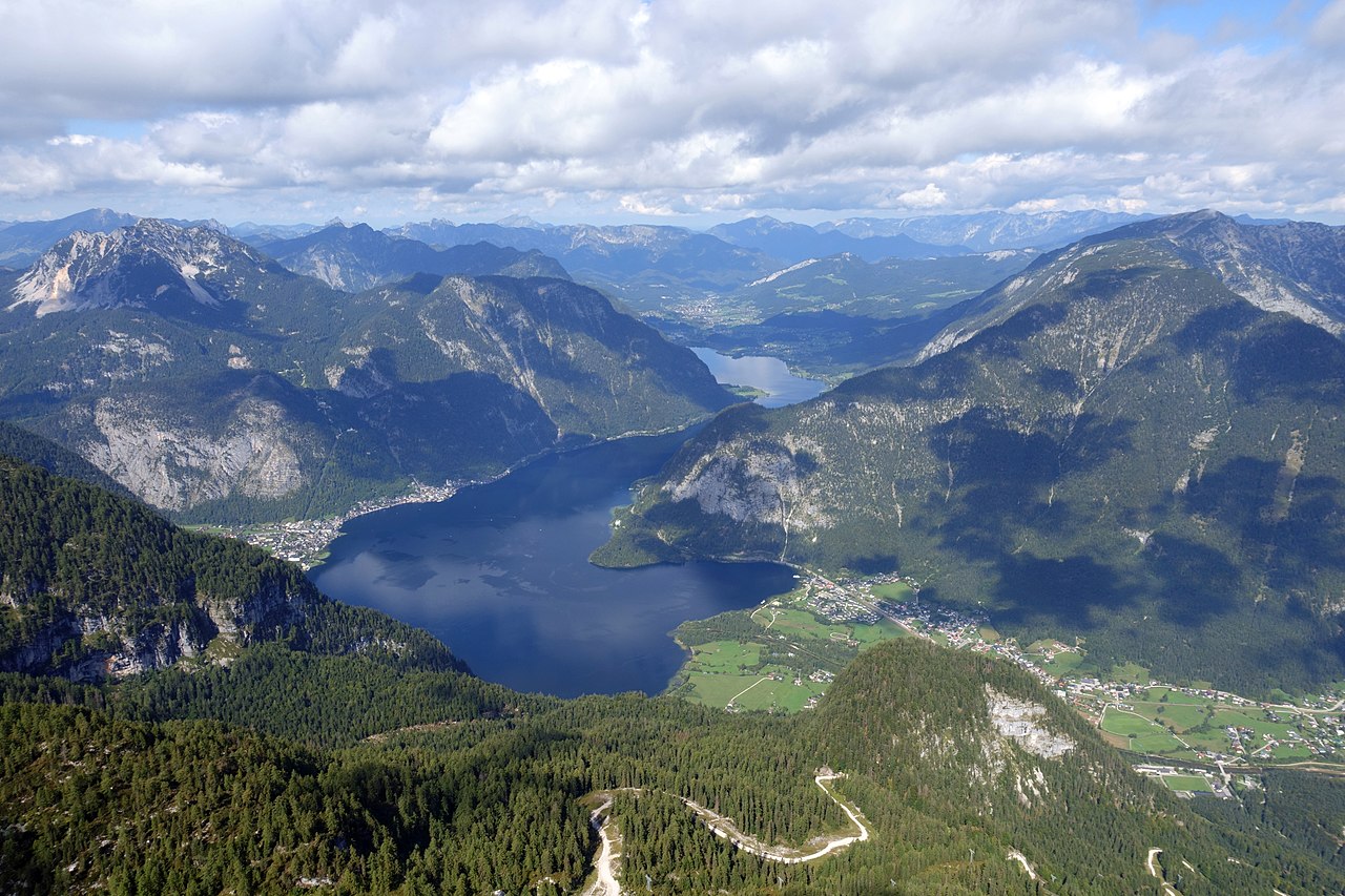
this unstable mass lies the Hallstätter See, a fjord-like basin carved by glacial. The lake's topography is unforgiving. It covers a surface area of approximately 8. 55 square kilometers plunges to a maximum depth of 125 meters (410 feet). The banks are not gradual; they are precipitous underwater cliffs that mirror the steepness of the mountains above. This bathymetry meant that for most of its history, Hallstatt had no shoreline to speak of. The "town" itself sits almost entirely on a small alluvial fan created by the Mühlbach stream. This fan is a pile of debris washed down from the mountain, creating a rare, flat protrusion into the lake. Without this geological accident, there would be no buildable land for the cluster of houses that defines the classic view.
The constraints of this terrain enforced a strict isolation until the late 19th century. In 1700, the only viable transport for heavy goods was the lake. The steep cliffs on the western bank made road construction technically impossible with the tools of the era. Salt, the region's economic lifeblood, had to be moved via the Soleleitung (brine pipeline), the world's oldest industrial pipeline, or by flat-bottomed boats called Plätten. The pipeline itself, operational since 1595 and repeatedly upgraded through the 1700s and 1800s, was a direct response to the terrain; since carts could not navigate the cliffs, the brine was dissolved and flowed through hollowed logs (later iron pipes) to the processing plant in Ebensee. The geology forced the industry to become hydraulic.
The 1750 fire, which devastated the market square, highlighted the lethal nature of this confinement. When the flames broke out, the residents were trapped between the burning timber structures and the freezing water. The rebuilding process reproduced the exact same cramped footprint because the geological walls offered no alternative. Houses were constructed with their backs dug into the salt mountain and their fronts on pylons driven into the lakebed, a method necessitated by the absence of solid ground.
It was not until 1890 that the isolation was partially breached by the construction of the Seestraße (Lake Road) along the west bank. This project required blasting directly into the hard limestone and the unstable Haselgebirge, a dangerous and expensive undertaking. Even then, the road was narrow and prone to rockfalls. The geological reality asserted itself again in the mid-20th century as tourism began to rise. The narrow lakeside road became a choke point, paralyzed by the very traffic it was meant to facilitate. The solution was the Hallstatt Tunnel.
Opened in June 1966, the tunnel is a testament to the town's fight against its own geography. Engineers bored through the Hallberg mountain, bypassing the fragile waterfront entirely. The excavation debris was not discarded; it was dumped into the lake to create the artificial "Badeinsel" (bathing island) and the parking area in the Lahn district. This act of terraforming was the only way to create new space in a location where nature provided none. The tunnel transformed Hallstatt from a remote outpost into a globally accessible destination, yet it also removed the natural barrier that had protected the village from mass overtourism.
Geological and Topographical Metrics of Hallstatt
Feature
Metric / Description
Implication for Settlement
Formation
Haselgebirge (Permian evaporite mélange)
High risk of subsidence; ductile rock limits heavy construction.
Lake Depth
Maximum 125 meters (410 ft)
Steep underwater banks prevent land reclamation; pylon architecture.
Buildable Area
Mühlbach Alluvial Fan
Concentrates 100% of the historic center in a flood-prone debris zone.
Tunnel Date
Opened June 1966
Bypassed the cliff-side road; enabled modern mass transit access.
Lake Volume
~558 million cubic meters
Acts as a massive heat sink, moderating local microclimate freezing in severe historic winters.
The Mühlbach stream, the creator of the alluvial fan, is also a dormant threat. While it provided the land for the town, it is a conduit for flash floods. In June 2013, heavy rains overwhelmed the stream's channel. The water, unable to drain into the saturated lake quickly enough, surged through the town center. The geology that built the foundation turned against it. The debris flow damaged homes and infrastructure, proving that the "stable" ground of the alluvial fan is a temporary pause in the mountain's pattern. Recent studies in 2023 and 2024 have intensified scrutiny on the slope stability above the town, particularly following a fire in the forest belt that weakened the root systems holding the soil in place.
, specifically the window from 2010 to 2026, these geological constraints have collided with the pressures of global tourism. The town cannot expand. There is no "suburbs" of Hallstatt because the vertical rock face forbids it. The capacity of the village is mathematically fixed by the square footage of the alluvial fan. When 10, 000 tourists descend on the town in a single day, they are occupying a space physically engineered by nature for a few hundred inhabitants. The parking areas in Lahn are built on fill; the roads are cut into cliffs; the houses cling to the slope. The "overtourism" emergency is frequently framed as a cultural problem, yet it is fundamentally a geological one. The container is too small for the volume it is being asked to hold.
Climate change introduces a new variable to this equation. As freezing levels rise, the permafrost and seasonal ice that bind the higher elevations of the Dachstein massif are degrading. This increases the frequency of rockfalls and landslides. The Haselgebirge, already mechanically weak, becomes more volatile when subjected to the erratic precipitation patterns observed in the 2020s. The 2013 flood was a warning; the geological record shows that the lake has swallowed parts of the shoreline before. The interaction between the deep, cold lake and the crumbling salt mountain remains the central of Hallstatt's existence, a physical reality that no amount of tourism revenue can alter.
Salt Mining Operations and Habsburg Monopoly (1700, 1850)
Geological Constraints and Lake Hallstatt Topography
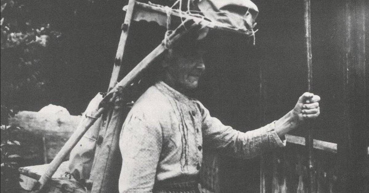
The period between 1700 and 1850 defined Hallstatt not as a town, as a rigid industrial machine owned and operated by the Habsburg monarchy. During this era, the *Salzkammergut* (literally "Salt Chamber Estate") functioned as a state-within-a-state, directly administered by the *Hofkammer* in Vienna. The town's existence was justified solely by the production of "white gold," a commodity so important it accounted for nearly 10 percent of the empire's total revenue by the late 18th century. ### The Mechanics of the Monopoly The Habsburg administration enforced a hermetic seal around Hallstatt's operations. Unlike other regions where private enterprise might flourish, Hallstatt was a closed economic zone. The *Salzamt* (Salt Office) in Gmunden held absolute authority, dictating everything from timber rights to marriage licenses. Production during this window relied heavily on "wet mining" (*Sinkwerksbau*). Miners did not simply hack rock salt from the walls; they leached it. Workers constructed large subterranean chambers, sealed them, and flooded them with fresh water. Over weeks, the water dissolved the salt from the *Haselgebirge* rock, creating a saturated brine (33% salinity). This brine was then drained and piped to boiling houses. This method solved a geological problem created a logistical one: fuel. Hallstatt's alpine location meant timber was scarce. By 1700, the forests immediately surrounding the lake were exhausted. The solution was the *Soleleitung*, a brine pipeline originally constructed between 1595 and 1607, which remained the lifeline of the industry throughout this period. Instead of bringing wood to the salt, the Habsburg engineers pumped the brine 40 kilometers north to Ebensee, where forests were still abundant. **Table: Key Infrastructure & Administrative Milestones (1700, 1850)** | Year | Event | Significance | |:--- |:--- |:--- | | **1734** | Discovery of "Man in Salt" | Prehistoric miner found preserved in the Kilb-Werk; proved ancient mining continuity. | | **1750** | Great Fire of Hallstatt | Destroyed the town center; rebuilding enforced strict fire codes and state planning. | | **1775** | *Maria-Theresia-Stollen* opened | New tunnel (originally *Kaiser Franz*) expanded access to deeper salt horizons. | | **1781** | Edict of Toleration | Joseph II allowed Protestants ( miners) to practice faith, reducing labor unrest. | | **1808** | Tunnel Renaming | The 1775 tunnel officially dedicated to Empress Maria Theresa, cementing imperial branding. | | **1840s** | Rise of Coal | Gradual shift began from wood to coal for boiling, reducing reliance on local timber. | ### The Human Cost: Women and the *Kernträgerinnen* While the state apparatus focused on brine, a parallel, brutal economy existed for "rock salt" (*Kernsalz*). Not all salt could be dissolved; high-purity chunks were mined dry. The transport of this rock salt fell to the *Kernträgerinnen*, the core carrier women. These women were the unseen engines of the mine. Because the brine pipeline could not transport solid rock, human labor was the only option. Records indicate that women, frequently the wives of miners, carried wooden backpacks (*Kraxen*) loaded with up to 40 kilograms of rock salt. They descended from the high valley (850 meters) to the lake level (508 meters) multiple times a day. This labor was not a choice a need. The *Salzamt* paid male miners a pittance, supplementing their wages with "Deputat" (allowances of salt, wood, and grain). This non-monetary payment trapped families in dependency. To buy tools or clothing, cash was needed, and the women's carrying work provided it. Historical accounts from the 19th century document that women continued this work even during advanced pregnancy, a testament to the economic desperation engineered by the monopoly's wage structures. ### Bureaucratic Control and the "Marriage Consensus" The Habsburg administration viewed the population of Hallstatt as inventory. To prevent the proliferation of a "pauper class," the Salt Office enforced the *Heiratskonsens* (marriage consensus). No miner could marry without the explicit permission of the *Salzamt*. Permission was frequently denied if the applicant could not prove they had a house or a secure position in the mines. This policy created a demographic bottleneck. Young men and women were forced to wait years for a vacancy in the workforce before they could start a family. The result was a stagnant population and a high rate of illegitimate births, which the church condemned the state caused. It was only under the reforms of Maria Theresa and later Joseph II that these restrictions began to loosen, though the bureaucratic grip remained tight until 1848. ### Technological Stagnation and Reform By the early 19th century, the Hallstatt operation faced a emergency of efficiency. The wet mining technique was slow. A single chamber could take months to leach. The *Hofkammer* in Vienna grew impatient with the declining yields relative to the booming salt mines in Hallein and the cheaper sea salt entering from Trieste. In response, engineers pushed deeper. The opening of the *Maria-Theresia-Stollen* in 1775 was a desperate bid to tap new, richer veins. Simultaneously, the pipeline infrastructure received constant patches. The *Gosauzwang*, a high carrying the pipeline over the Gosau valley, was repeatedly reinforced. These were not innovations of progress of survival. The monopoly was fighting to maintain its market share against a changing world. The year 1848 marked a turning point. The revolutions that swept Europe cracked the absolute authority of the *Salzamt*. The feudal constraints on the miners began to, setting the stage for the industrial shifts of the late 19th century. Yet, for 150 years, Hallstatt had served as a perfect model of an absolutist command economy: a town where the mountain, the water, and the people were all property of the Crown.
The Great Fire of 1750 and Late Baroque Reconstruction
On September 20, 1750, the structural integrity of Hallstatt faced its most severe test since the prehistoric salt collapses. A fire, ignited in the "Keferbäck" house, a bakery located on what is the site of Café Derbl, swept through the densely packed timber frame settlement. The blaze was not a residential tragedy; it was an industrial catastrophe that threatened the Habsburg Monarchy's most valuable revenue stream. Within hours, the fire consumed 35 primary buildings in the town center, killing four residents and incinerating the administrative heart of the salt trade. The destruction of the *Pfannhaus* (salt boiling house) represented a logistical nightmare. This facility was the engine where brine, piped from the high valley, was boiled down into crystalline salt. Its loss halted production in the market center and forced a permanent shift in Hallstatt's urban planning. The Court Chamber in Vienna, unwilling to risk another halt in production due to urban density, ordered the new boiling facilities to be constructed in the Lahn district, away from the residential core. This decision, born of the 1750 disaster, de-industrialized the Market Square, transforming it from a smoky production zone into the administrative and residential hub that tourists recognize today. Reconstruction efforts began immediately, driven by the deep pockets of the *Salinenamt* (Salt Administration). The rebuilding process occurred during the reign of Empress Maria Theresa, coinciding with the height of the Austrian Late Baroque period. Consequently, the town that emerged from the ashes did not resemble its medieval predecessor. The wealthy salt administrators and court secretaries, who held absolute power over the local population, commissioned stone structures with characteristic Baroque facades to replace the lost timber buildings. The *Seehotel Grüner Baum*, originally a salt merchant's residence, and the rebuilt rectory stand as physical evidence of this rapid, style-unified reconstruction. The architectural shift was not purely aesthetic; it was a display of hierarchy. While the common miners continued to live in wooden structures clinging to the steep slopes, the market center was solidified in stone. The Holy Trinity Column, erected in 1744, survived the flames to become the focal point of this new Baroque plaza. The visual identity of Hallstatt, frequently mistaken by casual observers as a medieval remnant, is factually a time capsule of 1750s disaster management and imperial investment. The logistics of this reconstruction were punishing. With no roads connecting Hallstatt to the outside world, every stone, beam, and slate tile had to be transported by barge across the lake (Plätten). The cost of the damage was estimated at 32, 025 guilders, a sum for the era. The Salt Administration absorbed these costs to ensure the workforce remained housed and the brine continued to flow. This dependency on the state monopoly cemented the town's social structure: Hallstatt was not a free market town a company town, owned and operated by the Crown. Fire remains the single greatest threat to Hallstatt's existence. The geological confinement that dictates the town's beauty also creates a fire trap. The houses are stacked vertically; the roof of one building frequently sits level with the basement of the neighbor above. On November 30, 2019, this vulnerability was exposed again when a fire broke out in a wooden hut and spread to two residential buildings near the waterfront. Unlike in 1750, modern fire crews utilized high-capacity pumps drawing directly from the lake, yet the density of the structures forced 109 firefighters to battle the blaze from narrow alleyways and boats. The 2019 incident served as a violent reminder that the "Baroque" town is still largely a timber construct behind its stucco facades. As of early 2026, the town is undergoing another phase of intensive structural intervention. The *Salzwelten* (Salt Mine) and the funicular railway, the primary economic engines of the modern tourism era, have been shut down for detailed renovations from January through June 2026. This closure, the most significant in decades, mirrors the reconstruction pauses of the past. Just as the 1750 fire forced a rethink of salt production logistics, the 2026 infrastructure overhaul addresses the wear and tear of mass tourism. The funicular, which carries hundreds of thousands of visitors annually, and the mine tunnels are being reinforced to meet safety standards that have evolved drastically since the 18th century. The fire protection in place for 2026 reflect the specific challenges of this terrain. Standard fire trucks cannot navigate the upper lanes of Hallstatt. The town relies on a specialized network of hydrants fed by mountain springs and lake pumps. Fire boats are stationed permanently to attack flames from the water, a tactic developed after analyzing the spread patterns of historical fires. The ban on unauthorized vehicles is not just for tourist comfort; it is a safety requirement to keep the single arterial lane clear for emergency responders. The loss of the Court Administration Office records in the 1750 fire created a permanent blind spot in the town's history. Centuries of birth, death, and production logs were turned to ash, leaving historians to piece together the pre-1750 era through external archives in Vienna and Gmunden. This archival void elevates the importance of the physical structures that remain. The Late Baroque houses are not just hotels and souvenir shops; they are the replacement data, the physical manifestation of the recovery plan enacted by the Habsburg bureaucrats. The relocation of the *Pfannhaus* to Lahn in 1751 also altered the environmental impact on the town center. For centuries, the smoke from the boiling pans had choked the Market Square and blackened the facades. The post-1750 layout allowed the center to breathe, inadvertently preparing it for its future role as a "clean air" health resort and later, a global icon. The Lahn district, previously a marshy periphery, was industrialized to house the new pans, a layout that in the current zoning where the bus terminals and modern visitor center are located. Current preservation laws in Hallstatt are among the strictest in Austria, directly influenced by the lessons of 1750. Homeowners are forbidden from altering the exterior appearance of the Baroque reconstruction. Windows, rooflines, and color palettes are dictated by the Federal Monuments Office (*Bundesdenkmalamt*). This regulatory stranglehold ensures that the town retains the specific visual character established after the Great Fire. It creates a static visual field, where the trauma of 1750 is frozen in time, preserved for the consumption of millions of visitors who walk the same cobblestones laid down to replace the charred ruins of the salt merchants' empire.
Comparative Analysis: 1750 Disaster vs. Modern Risk Factors
Factor
Situation in 1750
Situation in 2026
Primary Ignition Source
Open hearths, industrial salt boiling (wood-fired).
Lake pumps, fire boats, hydrant network, aerial support.
Economic Impact
Halted salt production; threatened Imperial revenue.
Halts tourism; threatens local business revenue.
Reconstruction Strategy
Rebuild in stone (Baroque); move industry to Lahn.
Strict preservation of 1750 aesthetic; internal modernization.
Johann Ramsauer and the 1846 Necropolis Excavations
Salt Mining Operations and Habsburg Monopoly (1700, 1850)
The systematic unearthing of the Hallstatt necropolis began not with academic intent, through an industrial accident. In November 1846, miners extracting gravel for road maintenance near the salt mine operations breached a of soil rich in bronze and iron artifacts. Johann Georg Ramsauer, the resident Bergmeister (Master of the Mine), arrived at the site to inspect the obstruction. Ramsauer was neither a historian nor a university-trained scholar; he was a bureaucrat and technical operations manager who had entered the salt works as a thirteen-year-old apprentice. This administrative background proved decisive. unlike the treasure hunters of the era who looted sites for gold, Ramsauer method the burial ground with the rigid discipline of a mining engineer. He treated the necropolis as he would a salt vein: a resource to be measured, cataloged, and extracted with precision.
Between 1846 and 1863, Ramsauer directed the excavation of 980 graves. His methodology established a protocol that predated modern archaeological standards by decades. Recognizing that the removal of artifacts destroyed the context of their deposition, he commissioned Isidor Engl, a local draughtsman, to produce detailed watercolor sketches of each grave in situ before the contents were disturbed. These "Protocol" manuscripts capture the exact arrangement of skeletal remains, the orientation of weapons, and the placement of ceramics. In an era before reliable field photography, Engl's watercolors preserved data that would otherwise have. They reveal a society in transition, documenting the shift from the Late Bronze Age (Urnfield culture) to the Early Iron Age, a period globally as the Hallstatt Culture (800, 450 BC).
The statistical density of the Ramsauer excavations provides a demographic dataset that remains relevant in 2026. The 980 graves contained approximately 19, 497 objects, ranging from iron swords to amber beads. The burial practices displayed a near-even split: 55 percent were inhumations (full body burials) and 45 percent were cremations. This duality suggests a society undergoing a ideological or ethnic shift, where two distinct mortuary traditions coexisted. The spatial distribution recorded by Ramsauer shows no clear segregation between the two rites, implying a stable integration of differing cultural practices within the mining community.
Table 4. 1: Comparative Inventory of Hallstatt Necropolis Excavations
Metric
Ramsauer Era (1846, 1863)
Modern Era (1992, 2026)
Graves Excavated
980
~1, 500 (Total confirmed)
Primary Documentation
Watercolor Sketches (Isidor Engl)
3D Scanning, DNA, Isotope Analysis
Dominant Material
Bronze / Iron Transition
Organic Textiles / Micro-residues
Skeletal Preservation
frequently discarded or lost
Retained for Pathological Study
Key Discovery
The "Hallstatt Culture" definition
Grave 111 (Textile/Bronze connection)
The material wealth extracted from these graves forces a re-evaluation of prehistoric economics. Ramsauer's inventory lists ivory sword hilts and amber jewelry in quantities that local sourcing. The amber, chemically traced to the Baltic Sea, and the ivory, originating from Africa, prove that Hallstatt was not an alpine outpost. It was a central node in a transcontinental trade network. Salt, the "white gold," purchased these luxury imports. The presence of glass vessels from the Caput Adriae (modern northern Italy) indicates that the miners maintained consistent commercial relations with Mediterranean civilizations long before the rise of Rome. These artifacts were not decorative; they served as markers of a rigid social hierarchy. The so-called "Warrior Graves," containing long iron swords and bronze vessels, contrast sharply with simpler burials, providing early evidence of a stratified labor force managed by a wealthy elite.
Modern forensic science has returned to Ramsauer's data to answer questions he could not ask. In July 2023, archaeologists from the Natural History Museum Vienna, working near the original Ramsauer site, discovered Grave 111. This cremation burial contained bronze spiral discs with preserved textile imprints, a finding that validates theories about organic containers used for ashes, evidence that had rotted away in the graves Ramsauer opened 170 years earlier. also, skeletal analysis conducted in 2025 and 2026 on the remaining bones has reconstructed the physical toll of salt mining. High rates of olecranon (elbow) fractures and spinal compression markers in the population align with the biomechanics of carrying heavy rock salt loads. The individuals in these graves were not just warriors or traders; they were the manual laborers who powered the mine.
The legacy of the 1846 excavation extends beyond the artifacts. Ramsauer's work defined the "Hallstatt C" and "Hallstatt D" chronological periods, becoming the standard yardstick for the European Early Iron Age. His refusal to prioritize gold over iron, or whole pots over shards, allowed for a typological sequence that helps date sites from France to Slovakia. Yet, the preservation of his notes highlights a serious problem in 19th-century archaeology: the loss of the biological data. While Ramsauer meticulously drew the skeletons, the bones themselves were frequently discarded or lost after excavation, as the scientific value of human DNA was unknown. Current researchers must rely on the small fraction of skeletal material that survived in museum storage to conduct genomic studies, making the 2023 discovery of undisturbed graves important for filling the biological gaps left by the 1846 industrial- clearance.
The site remains an active research zone. As of 2026, rockfall blocks and protective infrastructure projects continue to expose new sections of the cemetery. Each new find is cross-referenced against Ramsauer's original 19th-century grid. The accuracy of his measurements, made with simple surveying chains and compasses, holds up against modern GPS mapping. This continuity allows for a of Victorian-era data with 21st-century molecular archaeology, creating a continuous narrative of a community that lived, worked, and died on the steep slopes of the Salzberg for over a millennium.
Infrastructure Expansion and the 1966 Tunnel Opening
For nearly three centuries following 1700, Hallstatt remained an island in all name. The settlement's infrastructure was defined not by asphalt or rail, by the heavy, flat-bottomed wooden boats known as Fuhren and Trauner that navigated the Hallstätter See. Until the late 19th century, no continuous road connected the market square to the outside world. The only land access was a precarious mule track, the Saumpfad, and later the narrow "Malerweg" (Painter's Way), which clung to the rock face and was frequently impassable during winter. Salt left the valley via the brine pipeline established in 1595 or by barge, while residents and provisions arrived solely by water. This enforced isolation preserved the medieval architectural footprint strangled economic modernization.
The serious attempt to break this geological siege occurred in 1875, with the initial blasting for a road along the western shore. Yet, a fully drivable connection to the northern junction at Gosaumühle did not open until 1933. This engineering project was a violent intervention into the; builders had to blast away sections of the Dachstein limestone and construct the "Seestraße" on pylons driven into the lakebed. While this ended the water transport monopoly, it introduced a new emergency: the automobile. By the 1950s, the narrow market square, dating back to the 14th century, was choking on motorized traffic. Cars and buses squeezed through lanes designed for handcarts, threatening the structural integrity of the lakeside houses.
Faced with the choice of demolishing historic buildings to widen the road or boring through the mountain, the town faced a pivotal decision. In a 1958 referendum, 58 percent of residents voted against widening the lake road, mandating a subterranean solution. The result was the Hallstatt Tunnel, a massive infrastructure project that pierced the Hallberg mountain. Opened in June 1966, the tunnel bypassed the fragile town center entirely, rerouting traffic behind the settlement. The excavation debris from this project was not discarded; it was dumped into the lake at the southern end of the town to create the artificial land mass of the Lahn valley. This reclaimed land, formed from the guts of the mountain, would later become the primary staging ground for the 21st-century tourism explosion.
The 1966 tunnel was hailed as a victory for preservation, yet it inadvertently laid the groundwork for the town's modern saturation. By removing the physical bottleneck of the medieval streets, the tunnel allowed an uncapped volume of coaches and private vehicles to reach the Lahn terminal. The infrastructure designed to save the town became the funnel that drowned it. The parking galleries, built directly into the rock face near the Mühlbach Waterfall, and the open-air lots on the artificial Lahn island, were designed for the traffic volumes of the 1970s, not the mass tourism of the Instagram era. By 2018, these facilities were operating at serious failure, with buses idling in the tunnel itself, creating toxic air quality and gridlock that paralyzed the entire district.
Hallstatt Infrastructure Milestones (1890, 2026)
Year
Infrastructure Event
Impact on Access
1890
Completion of Seestraße (Lake Road)
localized road access; required pylons in lake.
1933
Gosaumühle Road Connection
Full vehicular access to the north; beginning of car traffic.
1966
Hallstatt Tunnel Opening
Traffic rerouted through Hallberg mountain; Lahn island created.
2020
Bus Slot System Implementation
Mandatory digital booking; capped daily bus entries.
2025
Tunnel Rockfall Galleries
Reinforcement of tunnel portals against geological instability.
In response to the collapse of logistical order, the municipality enforced a draconian traffic management system starting June 1, 2020. The "Bus Slot System" mandated that all coaches book a specific entry and exit window in advance, with a minimum stay requirement of 2 hours and 20 minutes to prevent "touch-and-go" tourism. This digital gatekeeping was the time since the 19th century that access to Hallstatt was strictly rationed. As of 2026, the fee for a single bus slot has risen to €126, a price point intended to discourage low-value volume. Even with these controls, the physical infrastructure remains under immense stress. The tunnel, 60 years old, requires constant monitoring for rockfall; recent renovations in 2023 and 2024 involved installing heavy-duty protective galleries at the portals, acknowledging that the mountain above remains as unstable as it was when the miners struck rock.
Austrofascism and Third Reich Administration (1934, 1945)
The Great Fire of 1750 and Late Baroque Reconstruction
The political ossification of Hallstatt began four years before the arrival of the Wehrmacht. Following the Austrian Civil War in February 1934, the Austrofascist regime of Engelbert Dollfuss dismantled the social fabric of the Salzkammergut. The region's salt miners, historically aligned with the Social Democratic Workers' Party and the *Schutzbund* paramilitary, found themselves stripped of representation. The "Ständestaat" (Corporate State) imposed a rigid, clerical-conservative hierarchy that mirrored the valley's geological confinement. The market square, once a forum for labor organization, became a stage for the *Vaterländische Front* (Fatherland Front), the only legally permitted political organization. For the miners of Hallstatt, the years between 1934 and 1938 were defined by surveillance, reduced wages, and the suppression of the labor unions that had previously negotiated their dangerous work underground. The annexation of Austria by Nazi Germany in March 1938, known as the *Anschluss*, replaced one form of authoritarianism with another, yet it arrived with the pledge of economic revitalization. The local population, battered by the Great Depression and the stagnation of the Austrofascist years, participated in the plebiscite of April 10, 1938. Official records for the district report a vote in favor of unification exceeding 99 percent, a statistic that reflects both genuine pro-German sentiment in the region and the coercive atmosphere of the polling stations. Administratively, Hallstatt was severed from its Austrian identity and absorbed into the *Reichsgau Oberdonau*. The salt mines, previously state-monopolized assets of the Austrian Republic, were reorganized under the centralized control of the Third Reich's industrial apparatus, aimed at maximizing extraction for the chemical and munitions industries. The war transformed the Hallstätter See from a tourist destination into a militarized zone of research and concealment. While Hallstatt itself remained a site of extraction, the adjacent village of Obertraun, visible across the lake and geologically linked to the Dachstein massif, hosted a darker infrastructure. The SS established a subcamp of the Dachau concentration camp (KZ-Außenlager Dachau-Obertraun) to exploit the cavernous geography of the region.
Facility
Location
Purpose
Labor Force
KZ-Außenlager Obertraun
Obertraun (East shore of Hallstätter See)
Construction of cable car to Krippenstein; Cave expansion
Dachau prisoners (Political, POWs)
Dachstein-Mammuthöhle
Dachstein Massif
Military research; Engine testing; Liquid oxygen storage
Forced Labor
Salt Mine Hallstatt
Hallstatt (West shore)
Industrial Salt Extraction
Local miners; Conscripted labor
Prisoners at the Obertraun subcamp were forced to construct the cable car systems leading to the Krippenstein and to expand the natural cave systems for military use. The Nazis intended to use the constant low temperatures of the Dachstein caves for testing aircraft engines and storing volatile chemicals, specifically liquid oxygen. The residents of Hallstatt, separated from this brutality only by the width of the lake, existed in a state of cognitive dissonance, maintaining the rhythms of the salt mine while smoke and exhaustion consumed the eastern shore. As the Allied bombing campaigns devastated German industrial centers in 1943 and 1944, the Salzkammergut became a "safe zone" for the Nazi elite and their plundered assets. The region's topography, a of limestone, offered protection against air raids. This geological security led to the implementation of the *Sonderauftrag Linz* (Special Mission Linz), Hitler's plan to amass the art of Europe for a "Führermuseum." While the neighboring Altaussee salt mine served as the primary repository for thousands of looted masterpieces, including the Ghent Altarpiece and Vermeer's *The Art of Painting*, Hallstatt functioned as a serious logistical node. The transport routes along the Traun River, passing through Lauffen and Hallstatt, saw a constant stream of heavy trucks moving crates of priceless art into the mountains. The salt mines were no longer just sources of sodium chloride; they were the vaults of the Third Reich. The final months of the war, early 1945, brought the collapse of the "Alpine " myth directly to Hallstatt. High-ranking Nazi officials, including Ernst Kaltenbrunner, the Austrian-born head of the RSHA (Reich Security Main Office) and a primary architect of the Holocaust, fled to the region. Kaltenbrunner established a headquarters in the Villa Kerry in Altaussee, his presence saturated the entire district. The roads through Hallstatt became clogged with retreating Wehrmacht units, refugees from the East, and desperate SS officers attempting to disappear into the *Totes Gebirge* (Dead Mountains). The most dangerous moment for Hallstatt came in May 1945, following the "Nero Decree." The fanaticism of the regional Gauleiter, August Eigruber, led to orders to destroy the salt mines to prevent the art treasures and industrial infrastructure from falling into Allied hands. Aerial bombs were transported into the tunnels of Altaussee. The local miners, realizing that the detonation would not only destroy the art also collapse the mountain and permanently ruin the region's economic future, engaged in a covert resistance. They successfully removed the fuses and sabotaged the demolition plan. This act of defiance by the salt miners, men who had been politically silenced since 1934, preserved the geological integrity of the mountain range. On May 8, 1945, the war ended. American troops from the 80th Infantry Division advanced into the Salzkammergut. They did not find a fortified redoubt of elite SS mountain troops, rather a chaotic mix of displaced persons, looted heritage, and a local population anxious to dissociate from the regime. Kaltenbrunner was tracked down and captured in a mountain cabin near the Wildensee, just a few kilometers from the Hallstatt salt works. The town of Hallstatt emerged from the war physically intact morally compromised, its economy shattered and its population swelled by refugees. The transition from the Third Reich to the Second Austrian Republic began not with a celebration, with the grim work of de-nazification and the logistical nightmare of repatriating the thousands of stolen artworks that had passed through the valley. The salt mine, the town's eternal constant, resumed production, its tunnels holding the secrets of a regime that had tried to turn the mountains into a tomb.
Hydroelectric Development and Waldbachstrub Regulation
The regulation of the Waldbachstrub and the subsequent development of hydroelectric infrastructure in Hallstatt represent a serious intersection of modern energy policy, historical water management, and urgent flood control measures. The primary hydroelectric facility, known as the Kleinwasserkraftwerk Hallstatt, was commissioned in August 2013 following a construction period that began in November 2012. This facility is operated by Hallstatt Wasserkraft GmbH, a joint venture where the Austrian Federal Forests (ÖBf) hold a 51% stake and the Market Municipality of Hallstatt holds the remaining 49%.
The plant utilizes the steep gradient of the Waldbach river, harnessing a gross head of approximately 330 meters. Water is diverted via a Tyrolean weir integrated into an existing structure, then transported through a 2. 5-kilometer penstock, partially buried and partially routed above ground, to the powerhouse. The facility operates a six-nozzle vertical Pelton turbine with a bottleneck capacity of roughly 4. 1 to 4. 3 megawatts. Annual production averages between 22 and 23 gigawatt-hours (GWh), sufficient to supply electricity to approximately 4, 500 to 6, 300 households, covering the demand of the entire Hallstatt-Dachstein-Salzkammergut World Heritage region.
Construction of the power plant coincided with severe flooding events in 2013, which reinforced the need for detailed water regulation in the Echerntal valley. The project was not an energy generation initiative also integrated significant flood protection and renaturation measures. Specifically, the channel of the Spraterbach tributary was renaturalized, removing hard concrete embankments to restore natural flow and improve fish passability. These engineering interventions were designed to mitigate the destructive chance of the Waldbach, a torrent (Wildbach) historically prone to rapid water level rises during heavy precipitation.
to the main turbine, the infrastructure was expanded in 2018 to include a drinking water power plant (Trinkwasserkraftwerk). This secondary system, with a capacity of 68 kilowatts, generates approximately 500, 000 kilowatt-hours annually by utilizing the pressure from the local drinking water supply network. This dual-use method maximizes the energy chance of the region's water resources without requiring further intervention.
Historical water regulation in the wider Hallstatt area dates back centuries, most notably with the Seeklause in Steeg. Constructed around 1540, this weir system at the outflow of Lake Hallstatt was designed to regulate water levels for salt transportation and timber drifting. While the Seeklause controls the lake and the River Traun, the modern regulation of the Waldbachstrub focuses on the high-alpine torrents feeding the valley. The 2013 hydroelectric project maintains a residual flow to preserve the visual integrity of the famous Waldbachstrub waterfall, a site of significant tourism value, balancing industrial utility with the preservation of the UNESCO World Heritage.
UNESCO World Heritage Inscription and Zoning Laws (1997)
Johann Ramsauer and the 1846 Necropolis Excavations
In December 1997, the UNESCO World Heritage Committee inscribed the Hallstatt-Dachstein/Salzkammergut region onto its list, fundamentally altering the area's legal and economic future. The designation Criteria iii and iv, recognizing the site as an exceptional testimony to a cultural tradition and an outstanding example of a settlement interacting with its environment. This decision did not honor the town's 7, 000-year history of salt mining; it codified a strict preservation mandate that prioritized historical integrity over modern development. The inscription froze the town's architectural evolution, transforming a living industrial community into a protected entity where visual consistency became the supreme legal requirement.
The 1997 listing immediately triggered the enforcement of rigorous federal and provincial statutes, most notably the Austrian Monuments Protection Act (Denkmalschutzgesetz) and the Upper Austrian Nature Protection Act. These laws imposed a rigid regulatory framework upon the 28, 637-hectare core zone and the surrounding 19, 863-hectare buffer zone. Under these measures, property owners lost the autonomy to modify their structures without extensive bureaucratic approval. Every renovation, from roof repairs to window replacements, must adhere to specific historical standards to maintain the "Gothic miners' settlement" aesthetic. This legal straitjacket ensures that the town retains its 18th-century appearance, it also severely restricts the construction of new housing, forcing the local population to compete for a fixed number of existing properties.
Zoning regulations within the protected area strictly delineate land use to prevent any encroachment that might mar the region's scenic value. The "Bebauungspläne" (zoning plans) and "Ortsbildsatzung" (townscape regulation) dictate that the natural terrain and the built environment must remain in a static, harmonious relationship. While these measures successfully prevented the sprawl seen in other alpine resorts, they created a closed real estate market. The scarcity of developable land, enforced by the buffer zone restrictions, drove property prices upward, detaching the cost of living from the local wage structure. The 1997 inscription, while intended to safeguard a unique cultural heritage, inadvertently engineered a demographic shift by making the town increasingly unaffordable for the families whose ancestors built it.
The Guangdong Replica and Intellectual Property Disputes (2011, 2012)
The signs of the replication effort appeared in early 2011, not through official diplomatic channels, via industrial espionage conducted in plain sight. Residents of Hallstatt noticed Asian guests who did not behave like typical tourists. These visitors spent days measuring the dimensions of window frames, counting the bricks in the market square, and photographing the precise angles of timber-frame joints. The operation was exposed when a Chinese architect reportedly left a set of detailed blueprints behind in a local hotel. These documents revealed that Minmetals Land, the real estate arm of China's largest metals trader, was not studying the village; they were building a full-, 1: 1 copy of it in Boluo County, Huizhou, Guangdong Province.
The of the project was. Minmetals Land invested approximately $940 million (6 billion RMB) to blast away hills and excavate an artificial lake to mimic the Hallstätter See. The engineers did not just copy the architecture; they terraformed the geography to match the specific alpine constraints of the Salzkammergut. The construction site in the subtropical heat of Guangdong soon featured an exact duplicate of the Evangelical Church of Christ, the Holy Trinity column, and the iconic market square. While the original Hallstatt evolved organically over 7, 000 years of salt mining history, the Guangdong version rose from the red earth in less than twelve months, driven by the brute force of state-owned capital.
This architectural cloning ignited a fierce debate regarding intellectual property rights for urban. Under international copyright law, the legal standing of the Austrian municipality was virtually nonexistent. While individual architectural blueprints are protected, the "look and feel" of a historic village, comprising public domain structures built centuries ago, cannot be trademarked. Hans-Jörg Kaiser of ICOMOS Austria (International Council on Monuments and Sites) admitted that legal recourse was impossible. The United Nations Educational, Scientific and Cultural Organization (UNESCO) designation, which Hallstatt received in 1997, offered prestige no legal shield against reproduction. The village had been pirated, and there was no court in the world that could problem a cease-and-desist order.
Initial reactions from the Hallstatt community ranged from shock to indignation. Residents described the project as a theft of their "soul" and a commodification of their heritage. Yet, the political leadership in Upper Austria quickly calculated the economic variables. Mayor Alexander Scheutz recognized that fighting a completed $940 million project was futile. Instead, he pivoted to a strategy of diplomatic embrace. In a move that surprised locals, Scheutz flew to Guangdong for the official opening ceremony on June 2, 2012. He signed a cultural exchange agreement, legitimizing the clone in exchange for what he hoped would be brand recognition in the burgeoning Chinese market.
The opening ceremony in Huizhou was a surreal display of globalization. Austrian brass bands played in the humid Chinese air while dancers in dirndls performed alongside Chinese security guards dressed in fantasy-European military uniforms. The replica functioned primarily as a high-end residential development for wealthy Chinese buyers, with the "village" serving as a central theme park and shopping district. the accuracy of the reproduction was unsettling; visitors to the Guangdong site could stand in the market square and see the same fountain, the same church spire, and the same cobblestones, all devoid of the history that created them.
Comparative Metrics: Hallstatt (Austria) vs. Hallstatt (China)
Metric
Original (Austria)
Replica (China)
Origin Date
Prehistoric (Salt mining ~5000 BC)
2011, 2012 (Construction)
Water Body
Hallstätter See (Glacial, 125m deep)
Artificial Lake (Excavated)
Primary Economy
Tourism / Salt Mining
Real Estate / Domestic Tourism
Church Structure
Evangelical Church (Built 1863)
Concrete Replica (No religious function)
Climate
Alpine (Snow in winter)
Subtropical (Humid, Monsoonal)
The economic of this duplication conventional logic. Rather than replacing the original destination, the Guangdong clone acted as a massive, permanent billboard for the Austrian village. In 2005, fewer than 50 Chinese tourists were recorded in Hallstatt. By 2011, that number had risen to 8, 700. Following the 2012 opening of the replica, the numbers exploded. By 2019, Asian tourists accounted for over 40% of all visitors to the Austrian site, with total visitor numbers crossing one million per year. The clone had not stolen tourists; it had manufactured a desire for the "authentic" experience, driving the over-tourism emergency that would engulf the village in the subsequent decade.
By 2026, the between the two towns has become a case study in urban irony. The Guangdong replica, initially marketed as a luxury residential zone, struggled with occupancy rates, frequently described by visitors as having a "ghost town" atmosphere where the buildings serve as backdrops for wedding photography. Conversely, the original Hallstatt suffers from the opposite problem: it is so overrun with visitors that the municipality has been forced to install turnstiles and limit bus entries. The intellectual property dispute of 2011 proved that while stone and mortar can be copied, the atmospheric context of a living settlement cannot. The clone remains a static stage set, while the original suffocates under the weight of the fame the copy helped generate.
Overtourism Metrics and Coach Bus Restrictions (2014, 2020)
Infrastructure Expansion and the 1966 Tunnel Opening
The demographic collision that occurred in Hallstatt between 2014 and 2020 represents one of the most extreme examples of overtourism in recorded urban history. A settlement defined for three centuries by its geological isolation and industrial solitude was, in the span of sixty months, converted into a high-throughput consumption venue. The metrics of this transformation are not statistical anomalies; they indicate a total collapse of the town's carrying capacity. By 2019, the village of approximately 750 residents hosted over one million visitors annually. This ratio of roughly 1, 300 tourists per inhabitant dwarfs the density of Venice or Barcelona, creating a sociographic pressure cooker where the primary industry, tourism, began to cannibalize the civic structure it relied upon. The catalyst for this explosion was a convergence of digital virality and pop culture mythology. While the town had long been a regional attraction, the release of the Disney film *Frozen* in 2013, paired with a popular South Korean drama *Spring Waltz*, fundamentally altered the Asian market's perception of the village. Hallstatt ceased to be viewed as a living community with a 7, 000-year salt mining heritage; it became a backdrop, a "selfie-stage" indistinguishable from a theme park set. This commodification was so absolute that in 2012, a state-owned Chinese mining company, Minmetals Land, constructed a full-, unauthorized replica of the entire village in Huizhou, Guangdong province. The existence of the copy did not satiate demand; instead, it acted as a massive advertisement, driving millions to seek the "original" version. The primary delivery method for this influx was the coach bus. Between 2014 and 2019, the logistical model of Hallstatt tourism shifted toward high-volume, low-yield "touch-and-go" visits. Tour operators in Vienna, Salzburg, and Prague marketed Hallstatt as a two-hour stopover. Buses would navigate the narrow alpine roads, discharge fifty passengers at the Lahn terminal, and idle while the group executed a rapid circuit of the town square. Data from the municipality shows that by 2019, the town was processing up to 90 coach buses per day during peak season. These vehicles disgorged up to 4, 500 people into a pedestrian zone less than one kilometer long, frequently within a concentrated three-hour window around midday. The infrastructure of a village built in the 1700s, designed for salt barges and mule tracks, could not sustain this industrial- human movement. The sewage treatment plant, engineered for a stable population and moderate seasonal fluctuation, faced serious overload. Waste management logistics broke down; the narrow streets, intended for local foot traffic, became impassable walls of pedestrians. Residents reported a complete loss of privacy, with tourists frequently entering private gardens and even homes, mistaking them for museum exhibits. Drones buzzed over the cemetery during funerals, and the noise pollution from the bus terminal reverberated off the steep rock walls of the Salzberg, destroying the acoustic tranquility that had defined the valley for millennia. Economic data from this period reveals a clear between visitor volume and local revenue. The "two-hour tourist" spends almost nothing. They purchase a coffee, a magnet, or a baked good, they do not book hotel rooms, dine in sit-down restaurants, or visit the salt mines which require a longer time commitment. The municipality bore the cost of waste removal, traffic control, and security, while the revenue was siphoned off by external tour bus companies and regional hubs like Salzburg where the tourists actually slept. The town was subsidizing its own destruction. In response to this untenable trajectory, the municipal government, led by Mayor Alexander Scheutz, enacted a draconian regulatory framework that came into full force in May 2020. This marked the end of the "open gate" era and the return to a restricted access model reminiscent of the 18th-century salt monopoly, though enforced by digital algorithms rather than imperial guards. The core of this regulation was the Bus Slot System. The new regime imposed a hard cap on the number of coach buses allowed to enter the terminal. The limit was set at 54 buses per day, a reduction of nearly 40% from the 2019 peaks. Crucially, the system eliminated the "touch-and-go" model by mandating a minimum stay of 2 hours and 20 minutes. This forced tour operators to alter their itineraries, making Hallstatt a primary destination rather than a convenient filler stop. To enforce this, a digital booking platform was established. Buses arriving without a pre-booked slot were physically turned away at the tunnel entrance or fined heavily. The parking fees were also restructured, with costs rising significantly to discourage casual entry. The logistics of the slot system required a complete reconfiguration of the Lahn valley floor. The terminal at the tunnel exit was strictly for drop-off and pick-up, with a maximum dwell time of 20 minutes. After discharging passengers, empty buses were forced to retreat to the P3 parking area, located 1. 5 kilometers away in Obertraun, to prevent engine idling and visual pollution in the village center. A shuttle service was introduced to ferry drivers back and forth, further formalizing the separation between the transport and the historic core. The implementation of these restrictions coincided with the onset of the COVID-19 pandemic, which provided an inadvertent "reset" button for the town. While visitor numbers plummeted globally in 2020 due to travel bans, the regulatory infrastructure installed during this pause ensured that the chaos of 2019 could not legally return once borders reopened. By 2024 and continuing into 2026, the slot system remained the governing law of the valley. Automated cameras monitor the tunnel entry, issuing immediate €150 fines to unauthorized large vehicles. The town also installed wooden privacy screens at popular "selfie points" to discourage loitering and protect residents from the gaze of the lens. This regulatory pivot represents a modern echo of Hallstatt's history. In 1700, the town was a restricted zone because its salt was too valuable to leave unguarded. In 2026, the town is a restricted zone because its image is too valuable to be consumed without limit. The transition from resource extraction to image extraction has not changed the fundamental need for border control; it has only changed the commodity being protected. The 54-bus cap is not a traffic rule; it is a survival method for a settlement that geology built to be small, the world demanded to be large.
Table 10. 1: Comparative Tourism and Regulation Metrics (2010, 2026)
Metric
2010 (Pre-Boom)
2019 (Peak emergency)
2020 (Regulation Start)
2026 (Managed State)
Annual Visitors
~250, 000
~1, 000, 000+
~150, 000 (COVID)
~700, 000 (Capped)
Daily Bus Peak
20-30
80-90
0-10 (Lockdown)
54 (Strict Limit)
Visitors per Resident
330: 1
1, 300: 1
200: 1
930: 1
Min. Bus Stay
None
None
2h 20m
2h 20m
Entry Control
Open Access
Open Access
Digital Slot System
Automated/Camera
Primary Market
DACH Region
East Asia / Global
Domestic (Austria)
Global (Managed)
Waterfront Fire Damage and Reconstruction Costs (2019, 2021)
On November 30, 2019, at approximately 3: 30 AM, a blaze erupted on the Hallstatt waterfront that exposed the extreme fragility of the town's urban fabric. The fire originated in a wooden hut at Seestraße 179, a location of historical irony. This specific plot stands on the site of the "Keferbäck" (Baker's House), the exact ignition point of the catastrophic 1750 fire that once incinerated 35 houses and the town's baroque center. In 2019, the flames spread rapidly from the shed to the adjacent residential buildings, tearing through the dry timber of the tightly packed heritage structures. By the time 109 firefighters from eight regional brigades brought the inferno under control, four buildings lay in ruins, their roofs collapsed and interiors gutted by a combination of fire and the water required to extinguish it.
The damage assessment revealed a logistical nightmare that would define the reconstruction efforts throughout 2020 and 2021. Unlike a standard construction site, the Hallstatt waterfront is inaccessible to heavy. The narrow, car-free streets and the precipitous drop into the Hallstätter See meant that standard demolition and supply chains were impossible. Every beam, slate, and bag of cement had to be maneuvered into place using small, specialized vehicles or transported via barge across the lake. This geographical confinement, which serves as a picturesque backdrop for millions of tourist photographs, transformed into a severe bottleneck that inflated both the timeline and the cost of recovery.
Reconstruction costs for the affected properties were driven not only by logistics by the strict preservation mandates of the UNESCO World Heritage status. The Federal Monuments Office (Bundesdenkmalamt) required that the external facades be restored to their pre-fire appearance, necessitating the use of traditional materials and craftsmanship. While private insurance settlements remain confidential, municipal records and regional construction data suggest the price per square meter for such heritage restoration exceeds standard Austrian construction costs by a factor of three. The rebuilding process required a specialized workforce capable of integrating modern fire safety standards, such as fire-resistant core walls and updated electrical systems, into 18th-century wooden frameworks without altering the visible historic fabric.
Comparative Fire Logistics: 1750 vs. 2019
Metric
1750 "Keferbäck" Fire
2019 Waterfront Fire
Ignition Point
Baker's House (Keferbäck)
Wooden Shed (Seestraße 179)
Destruction
35 Houses, Court Office, Archives
4 Buildings (Roofs/Upper Floors)
Response Time
Hours (Bucket Brigades)
Minutes (109 Firefighters)
Reconstruction
Late Baroque Redesign
Strict Heritage Restoration
Logistics
Local Timber Sourcing
Barge/Small Truck Transport
The timing of the fire, occurring just before the onset of the COVID-19 pandemic, created a unique anomaly in the town's history. The reconstruction work in 2020 coincided with a total collapse of international tourism, allowing heavy restoration work to proceed without the interference of the usual 10, 000 daily visitors. For the time in decades, construction crews could navigate Seestraße without parting a sea of pedestrians. This absence of crowds, while economically devastating for the town's revenue, likely accelerated the structural repairs of the waterfront. By 2021, the external shells of the damaged buildings were largely restored, erasing the visible scars of the fire just as visitors began to return.
This event served as a stress test for Hallstatt's disaster resilience. The town's density, where eaves frequently touch and wooden balconies overlap, creates a continuous fuel route for fire. The 2019 incident forced a re-evaluation of hydrants and emergency access points along the lakefront. It demonstrated that even with modern firefighting technology, the geological and architectural constraints of Hallstatt remain its greatest hazard. The reconstruction proved that preserving this living museum requires a constant, high-cost battle against the very elements, fire, water, and , that shaped its history.
Population Statistics and Entry Fee Legislation (2024, 2026)
The demographic trajectory of Hallstatt from 1700 to 2026 reveals a clear inversion of purpose: a settlement once defined by the labor-intensive extraction of salt has morphed into a stage set for the consumption of images. In the 18th century, under the strict administration of the Habsburg *Salinenamt*, the population was tightly regulated by the economic output of the salt mines. Census records from the mid-1700s suggest a functional community of approximately 1, 000 to 1, 200 inhabitants, comprised almost exclusively of miners, forestry workers, and cooperage artisans. Residence was a privilege granted by employment in the imperial monopoly. By 2026, the resident population has contracted to an estimated 737 individuals, while the transient population, tourists who contribute zero labor to the local industry, has surged to over 1. 2 million annually. This represents a ratio of approximately 1, 628 visitors for every single permanent resident, a metric of density that exceeds even the most crowded urban centers of Venice or Barcelona. The collapse of the resident population is not a function of rural flight, a direct consequence of the "museumification" of the housing stock. Real estate data from 2024 indicates that property prices in Hallstatt have decoupled from local wage realities, driven by the conversion of residential units into short-term rentals and investment vehicles. A 2025 report by the Austrian statistical bureau noted that while the district of Gmunden saw moderate price stabilization, Hallstatt's price-per-square-meter remained artificially inflated, barring young families or service workers from entering the market. The town is no longer a dwelling place; it is a high-yield asset class.
The legislative response to this demographic siege reached a serious inflection point between 2023 and 2025. For decades, access to Hallstatt was unrestricted, a legacy of its status as a public municipality connected to the federal road network. The breaking point occurred on July 27, 2023, when frustration among the remaining locals boiled over. In an act of civil disobedience, residents physically blocked the tunnel on the L547 road, the town's primary artery, demanding a cap on daily visitor numbers and a curfew for tour buses. This protest forced the municipal government, led by Mayor Alexander Scheutz, to accelerate restrictive measures that had previously been stalled by legal ambiguity.
The primary instrument of control implemented in the 2024, 2026 window is the "Bus Slot System," a digital regulatory framework that functions as a de facto entry tax. Unlike a turnstile fee, which faces constitutional challenges regarding freedom of movement on public roads, the slot system the logistical choke point of heavy transport. As of May 1, 2025, the fee for a single bus slot was hiked to €126, up from €105 in the previous fiscal year. This fee is not for parking; it is for the right to stop. The legislation mandates that every commercial coach must book a specific time window in advance. Buses arriving without a slot are legally prohibited from disembarking passengers and are turned away at the tunnel checkpoint. The system enforces a minimum stay of 2 hours and 20 minutes, a rule designed to eliminate "hit-and-run" tourism where groups swarm the market square for twenty minutes of photography before departing.
The Hallstatt Asymmetry: Population vs. Visitation (1750, 2026)
Era
Resident Population
Annual Visitors (Est.)
Primary Economic Driver
Access Control method
1750
~1, 100
< 500
Imperial Salt Monopoly
Habsburg Employment Decree
1900
~1, 200
~5, 000
Salt & Early Alpinism
Geography (Rail/Boat access only)
1997
923
~50, 000
UNESCO Heritage Status
None (Open Access)
2019
778
1, 000, 000+
Mass Tourism (Social Media)
None (System Failure)
2026
737
1, 200, 000 (Capped)
Experience Economy
Bus Slot System (€126) / Digital Monitoring
The debate over individual entry fees for pedestrians and private cars remains legally. Throughout 2024 and 2025, the municipal council examined the "Venice Model," which introduced a direct €5, €10 access charge for day-trippers. Yet, Austrian federal law treats the streets of Hallstatt as public thoroughfares, making a blanket toll unconstitutional without a change at the federal level. Consequently, the town has resorted to "fiscal friction" to deter private vehicle traffic. Parking fees for private cars in the P1 and P2 lots have been aggressively scaled, with 2025 rates punishing short stays and incentivizing overnight bookings. The strategy is explicit: if the town cannot legally ban day-trippers, it make their visit economically irrational.
The effectiveness of these measures is visible in the 2025, 2026 data. While the total number of visitors has not plummeted, the composition of the crowd has shifted. The bus slot system has successfully capped the number of large tour groups at approximately 54 coaches per day, flattening the midday peak that previously paralyzed the town center. Revenue from these fees, projected to exceed €2 million annually by the end of 2026, is a serious component of the municipal budget, funding infrastructure repairs that the shrinking tax base of 737 residents could never support. The town has become a corporation where the tourists are the customers and the residents are the unwilling staff.
This financial dependency creates a dangerous feedback loop. To maintain the infrastructure required to protect the town from tourism, Hallstatt must generate revenue from tourism. The 2026 budget allocates significant funds to "visitor management systems," including sensor-based crowd monitoring and traffic marshals. The "Quality Tourism" strategy, officially adopted in 2024, aims to pivot the demographic from high-volume, low-spend bus groups to lower-volume, high-spend overnight guests. Yet, the housing statistics show that this pivot has not arrested the demographic decline. The conversion of homes into boutique accommodation continues, leaving the town with a "hollow core", a beautifully preserved shell with few lights on in the winter evenings.
The situation in 2026 stands as a warning to other heritage sites. Hallstatt has successfully engineered a legislative barrier to manage the flow of machines (buses and cars), it has failed to solve the human equation. The population continues to age and shrink, with the local school struggling to maintain enrollment numbers. The "Slot System" has brought order to the parking lots, it has not brought families back to the historic houses. The town exists in a state of suspended animation, its survival secured by the very forces that erased its original identity. The salt mines, once the beating heart of the community, are an underground attraction, while the surface world is governed by the strict rhythm of the entry slot.
Why it matters: Indigenous grazing rights are under threat as multinational agribusinesses encroach on ancestral lands. The systemic erasure of grazing rights is leading to displacement and environmental…
What do we know about Geological Constraints and Lake Hallstatt Topography?
Hallstatt exists in a state of geological confinement. The settlement is not situated near a mountain; it is wedged into a precarious fracture zone where the Northern Calcareous Alps collide with the deep waters of the Hallstätter See.
What do we know about Salt Mining Operations and Habsburg Monopoly?
The period between 1700 and 1850 defined Hallstatt not as a town, as a rigid industrial machine owned and operated by the Habsburg monarchy. During this era, the *Salzkammergut* (literally "Salt Chamber Estate") functioned as a state-within-a-state, directly administered by the *Hofkammer* in Vienna.
What do we know about The Great Fire of and Late Baroque Reconstruction?
On September 20, 1750, the structural integrity of Hallstatt faced its most severe test since the prehistoric salt collapses. A fire, ignited in the "Keferbäck" house, a bakery located on what is the site of Café Derbl, swept through the densely packed timber frame settlement.
What do we know about Johann Ramsauer and the Necropolis Excavations?
The systematic unearthing of the Hallstatt necropolis began not with academic intent, through an industrial accident. In November 1846, miners extracting gravel for road maintenance near the salt mine operations breached a of soil rich in bronze and iron artifacts.
What do we know about Infrastructure Expansion and the Tunnel Opening?
For nearly three centuries following 1700, Hallstatt remained an island in all name. The settlement's infrastructure was defined not by asphalt or rail, by the heavy, flat-bottomed wooden boats known as Fuhren and Trauner that navigated the Hallstätter See.
What do we know about Austrofascism and Third Reich Administration?
The political ossification of Hallstatt began four years before the arrival of the Wehrmacht. Following the Austrian Civil War in February 1934, the Austrofascist regime of Engelbert Dollfuss dismantled the social fabric of the Salzkammergut.
What do we know about Hydroelectric Development and Waldbachstrub Regulation?
The regulation of the Waldbachstrub and the subsequent development of hydroelectric infrastructure in Hallstatt represent a serious intersection of modern energy policy, historical water management, and urgent flood control measures. The primary hydroelectric facility, known as the Kleinwasserkraftwerk Hallstatt, was commissioned in August 2013 following a construction period that began in November 2012.
What do we know about UNESCO World Heritage Inscription and Zoning Laws?
In December 1997, the UNESCO World Heritage Committee inscribed the Hallstatt-Dachstein/Salzkammergut region onto its list, fundamentally altering the area's legal and economic future. The designation Criteria iii and iv, recognizing the site as an exceptional testimony to a cultural tradition and an outstanding example of a settlement interacting with its environment.
What do we know about The Guangdong Replica and Intellectual Property Disputes?
The signs of the replication effort appeared in early 2011, not through official diplomatic channels, via industrial espionage conducted in plain sight. Residents of Hallstatt noticed Asian guests who did not behave like typical tourists.
What do we know about Overtourism Metrics and Coach Bus Restrictions?
The demographic collision that occurred in Hallstatt between 2014 and 2020 represents one of the most extreme examples of overtourism in recorded urban history. A settlement defined for three centuries by its geological isolation and industrial solitude was, in the span of sixty months, converted into a high-throughput consumption venue.
What do we know about Waterfront Fire Damage and Reconstruction Costs?
On November 30, 2019, at approximately 3: 30 AM, a blaze erupted on the Hallstatt waterfront that exposed the extreme fragility of the town's urban fabric. The fire originated in a wooden hut at Seestraße 179, a location of historical irony.
What do we know about Population Statistics and Entry Fee Legislation?
The demographic trajectory of Hallstatt from 1700 to 2026 reveals a clear inversion of purpose: a settlement once defined by the labor-intensive extraction of salt has morphed into a stage set for the consumption of images. In the 18th century, under the strict administration of the Habsburg *Salinenamt*, the population was tightly regulated by the economic output of the salt mines.
Why it matters: Comunicaciones Celulares S. A. (Comcel), known as Tigo Guatemala, reached a deferred prosecution agreement with the DOJ, requiring a payment of $118.2 million for violating…
Why it matters: Freedom of Information (FOI) and Right to Information (RTI) acts are crucial for transparency and accountability, granting citizens access to public information. Appeals systems play…
Why it matters: Direct-to-consumer DNA kits for personalized fitness are facing serious ethical and practical issues. Regulators and experts warn about misleading claims and accuracy concerns surrounding genetic…
Why it matters: Pakistan has been tightening control over non-governmental organizations since the early 2010s, leading to the shutdown of dozens of aid agencies and creating a climate…
Why it matters: Americans face soaring prescription drug prices, leading to financial hardship and health risks. Drug companies are accused of price gouging, driving up costs for essential…
Why it matters: Leaders and policymakers are questioning traditional metrics like GDP, ROI, and standardized tests, arguing they don't fully capture human well-being and sustainability. A global movement…
Get updates on this place
Get verified alerts when this file is updated (verification required).