Verified Against Public And Audited RecordsLast Updated On: 2026-03-05
Reading time: ~49 min
File ID: EHGN-PLACE-35915
Investigative Bio of Istanbul
Strategic Control of the Bosphorus and Montreux Protocols (1936, 2026)
For over three centuries, the Bosphorus Strait has defined the strategic calculus of empires, serving as the only maritime exit for the Black Sea powers and a serious choke point for global trade. From 1700 until the early 20th century, the "Straits Question" dominated European diplomacy, shifting the waterway from an internal Ottoman lake to a contested international corridor. Russian expansionism in the 18th century forced the Ottomans to cede exclusivity, culminating in the 1833 Treaty of Hünkâr İskelesi, which briefly turned the Black Sea into a Russian preserve. European powers countered this with the London Straits Convention of 1841, which closed the straits to all non-Turkish warships in peacetime, a rule that held until the catastrophic collapse of the Ottoman Empire in 1918.
The modern regime governing this waterway emerged from the ashes of the Turkish War of Independence. While the 1923 Treaty of Lausanne demilitarized the straits and placed them under international supervision, the rising threat of fascism in Europe allowed Turkey to renegotiate terms. The Montreux Convention of 1936 stands as a rare diplomatic victory for the early Turkish Republic. It restored Turkish military control over the Bosphorus and Dardanelles and established a complex system of tonnage and duration limits for non-Black Sea warships. Specifically, non-riparian powers are limited to a total aggregate tonnage of 45, 000 tons in the Black Sea, and their vessels cannot remain for more than 21 days. This legal architecture prevents any external naval power, including the United States, from maintaining a permanent fleet off the Russian coast.
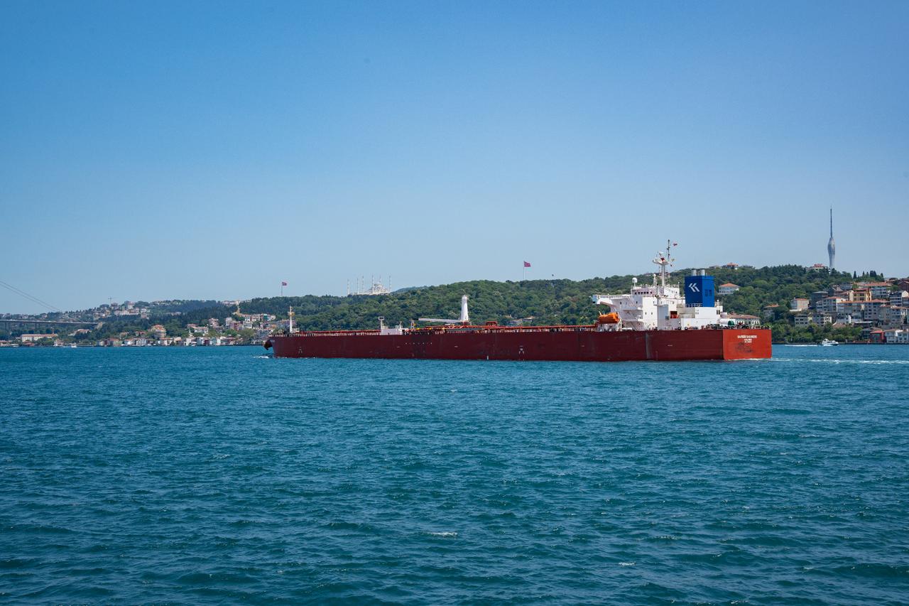
Throughout the Cold War, the Soviet Union pressured Ankara to revise Montreux, demanding joint defense of the straits, a demand that drove Turkey into NATO in 1952. The straits remained a flashpoint, yet the traffic profile changed drastically. Once a corridor for grain and timber, the Bosphorus became a major energy transit route. By the 2000s, millions of barrels of Russian and Caspian oil passed through the 700-meter-wide choke point daily, navigating sharp turns and strong currents that make the Bosphorus one of the most difficult waterways to navigate. Accidents like the 1979 collision involving the tanker Independenta demonstrated the catastrophic risks of this congestion.
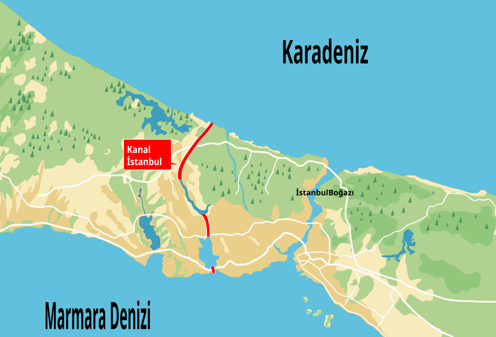
In 2011, then-Prime Minister Recep Tayyip Erdoğan proposed "Kanal Istanbul," an artificial waterway designed to bypass the Bosphorus. Framed as a safety measure to divert hazardous tanker traffic, the project also carried geopolitical. Critics argued the canal would undermine Montreux by creating a route for warships unrestricted by the 1936 treaty. Groundbreaking for the Sazlıdere occurred in June 2021, yet by early 2026, the project remains largely stalled. Economic turbulence, the devastating 2023 earthquake, and immense environmental opposition have halted substantive excavation. While the government insists the project is paused, the physical reality in 2026 shows little progress beyond initial infrastructure works, leaving the Montreux regime as the sole legal framework.
The Russian invasion of Ukraine in February 2022 tested this framework to its limit. On February 28, 2022, Turkey invoked Article 19 of the Montreux Convention, recognizing the conflict as a war and blocking the passage of belligerent warships. This decision severed the Russian Black Sea Fleet from its Mediterranean reinforcements. For four years, Ankara has maintained this blockade, denying passage to both Russian and NATO combat vessels. This strict application has trapped Russia's naval assets in the Black Sea, where they have suffered significant attrition from Ukrainian drone and missile strikes, unable to rotate or resupply from the open ocean.
Traffic data from 2023 to 2025 reveals a waterway operating at maximum capacity, even with the warship ban. The volume of commercial transit has fluctuated remains immense, driven by grain exports and energy flows. In 2025 alone, over 40, 000 vessels navigated the Bosphorus, carrying approximately 1. 58 billion gross tons of cargo. The following table details the traffic metrics through the Bosphorus Strait during the peak of the Ukraine conflict.
Bosphorus Strait Maritime Traffic (2023, 2025)
Year
Total Vessel Transits
Tanker Transits
Total Cargo (Gross Tons)
Warship Transits
2023
39, 000
8, 600
416 Million
0 (Belligerents)
2024
41, 363
9, 669
425 Million
0 (Belligerents)
2025
40, 172
9, 450
410 Million
0 (Belligerents)
As of 2026, the strategic control of the Bosphorus remains Turkey's most potent geopolitical lever. The "Kanal Istanbul" alternative exists only on paper, while the Montreux Convention operates as the de facto law of the Black Sea. Ankara's refusal to open the gates has forced Russia to rely on rail and river transport for logistics, fundamentally altering the maritime dimension of the war. The straits, once a site of imperial contest, serve as a hermetically sealed gate, enforcing a containment zone that neither Moscow nor Washington can breach.
North Anatolian Fault Activity and Seismic Retrofitting Deficits
Strategic Control of the Bosphorus and Montreux Protocols (1936, 2026)
The North Anatolian Fault (NAF) represents one of the most distinct and dangerous tectonic method on Earth, a right-lateral strike-slip fault system running approximately 1, 200 kilometers across northern Turkey. For Istanbul, the fault is not a geological feature a suspended sentence. The city sits less than 20 kilometers north of the Main Marmara Fault, a segment of the NAF that has remained seismically locked since 1766. The mechanics of this system are governed by a phenomenon known as "stress transfer," where the rupture of one segment loads tectonic stress onto the adjacent segment. Since the catastrophic 1939 Erzincan earthquake (Magnitude 7. 8) in eastern Turkey, a domino-like sequence of major ruptures has migrated westward, 1942, 1943, 1944, 1951, 1957, 1967, culminating in the 1999 Izmit earthquake. This progression has left the Marmara Sea segment as the only major gap in the sequence, a "seismic gap" accumulating for over 260 years.
The historical record provides a grim template for the expected rupture. The last time this specific segment broke was May 22, 1766. That event, estimated at magnitude 7. 1, devastated Constantinople. The Fatih Mosque complex collapsed, the Topkapı Palace was rendered uninhabitable, and the city walls were breached. A tsunami was observed in the Bosphorus, and aftershocks continued for months, forcing the population to live in tents. More, the July 1894 earthquake (Magnitude ~7. 0) centered in the Çınarcık Basin killed an estimated 1, 349 people and caused a tsunami of 1. 5 meters. These events confirm that the fault is capable of generating high-magnitude shocks and tsunamis directly adjacent to the historic peninsula and the densely populated southern coasts.
The turning point for modern Istanbul was August 17, 1999. The magnitude 7. 4 Izmit earthquake struck just 80 kilometers east of the city. While the epicenter was in Kocaeli, the shockwaves killed 981 people in Istanbul alone, primarily in the Avcılar district, where soil liquefaction amplified the ground motion. The disaster exposed the widespread rot in Turkey's construction sector: the use of sea sand in concrete, insufficient steel reinforcement, and a total disregard for zoning regulations. The 1999 event loaded significant additional stress onto the Marmara segment, increasing the probability of a magnitude 7. 0+ earthquake clear Istanbul to over 60% within 30 years. As of March 2026, that window is closing.
In the aftermath of 1999, the Turkish government and international bodies launched the Istanbul Seismic Risk Mitigation and Emergency Preparedness Project (ISMEP). Financed by over €2. 5 billion in loans from the World Bank, AIIB, and others, ISMEP has been the primary vehicle for public sector retrofitting. By early 2026, the project had retrofitted or reconstructed over 1, 400 schools, 115 hospitals, and dozens of administrative buildings. These interventions have undoubtedly saved lives in chance future scenarios, ensuring that serious infrastructure remains operational. The reinforcement of the Governorship building and the reconstruction of the Okmeydanı and Göztepe hospitals stand as engineering successes.
Yet, the private housing stock remains a catastrophic liability. Istanbul is home to over 1. 2 million buildings, and estimates suggest that at least 200, 000 of them are at serious risk of collapse or severe damage in a major event. The "Urban Transformation" (Kentsel Dönüşüm) law, passed in 2012, was intended to replace risky stock with earthquake-resistant structures. In practice, it frequently mutated into a tool for gentrification. Developers targeted high-value neighborhoods like Kadıköy and Bağdat Avenue for lucrative reconstruction projects, replacing already decent buildings with luxury apartments, while the most shantytowns (gecekondu) and dense, low-quality housing stocks in districts like Zeytinburnu, Esenler, and Güngören were frequently neglected due to lower profit margins.
The most egregious policy failure occurred in 2018 with the "Zoning Amnesty" (İmar Barışı). In a move to raise state revenue before elections, the government allowed the registration of illegal construction projects, buildings that violated safety codes, height restrictions, or zoning plans, in exchange for a fee. In Istanbul alone, 294, 166 building registration certificates were issued. This legalized structural vulnerabilities, granting a veneer of legitimacy to buildings that engineers had never inspected. The consequences of this policy were clear illustrated during the February 2023 Turkey-Syria earthquakes, where amnesty-granted buildings in the southern provinces collapsed, killing thousands. For Istanbul, the 2018 amnesty remains a dormant warrant for mass casualties.
Major Earthquakes Affecting Istanbul (1700, 2026)
Date
Location / Segment
Magnitude
Impact on Istanbul
May 22, 1766
Marmara Sea (East)
~7. 1
Fatih Mosque destroyed; Topkapı Palace damaged; Tsunami. Last rupture of the current seismic gap.
July 10, 1894
Gulf of Izmit
~7. 0
Grand Bazaar damaged; 1, 349+ deaths; Tsunami observed.
Aug 9, 1912
Mürefte-Şarköy
7. 3
Heavy damage in western Marmara; felt strongly in Istanbul.
Aug 17, 1999
Izmit (Kocaeli)
7. 4
981 deaths in Istanbul (Avcılar); 17, 000+ total region-wide. Loaded stress on Istanbul segment.
Sep 26, 2019
Silivri (Offshore)
5. 8
Minor damage; panic; minaret collapse. Warning sign of stress accumulation.
As of 2026, the between public and private preparedness is the defining characteristic of Istanbul's seismic risk. While schools and have been fortified, the residential fabric of the city remains brittle. The Istanbul Metropolitan Municipality (IMM) has accelerated rapid scanning methods to identify "immediate collapse" risks, the sheer of the problem the budget and logistical capacity for relocation. The economic paralysis following the currency emergency of the early 2020s further slowed private retrofitting efforts, as construction costs soared. The city waits, caught between the certainty of geological time and the inertia of human governance.
Lira Volatility and Hyperinflationary Cycles (2018, 2026)
The collapse of the Turkish Lira between 2018 and 2026 mirrors the "Great Debasement" of the Ottoman kuruş two centuries prior, yet the speed of modern capital flight has compressed decades of imperial decline into a single, brutal decade. In the early 19th century, the Ottoman state debased the silver content of its currency by 83% to fund wars and cover treasury deficits, a slow-motion disintegration that eventually forced the empire onto the gold standard. The modern republic's monetary emergency, triggered in 2018 by the Brunson affair and exacerbated by an ideological war against interest rates, achieved a similar destruction of wealth. By March 2026, the lira trades at approximately 44. 00 against the US dollar, a catastrophic devaluation from 3. 76 in early 2018. This erasure of purchasing power has fundamentally altered the socioeconomic fabric of Istanbul, turning the metropolis into a city where rent frequently exceeds the total monthly income of minimum-wage workers.
The emergency entered its most acute phase in late 2021, when the administration pursued an "unorthodox" monetary policy that slashed interest rates even with soaring inflation. This experiment, justified by the rhetoric of fighting an "interest rate lobby," caused the lira to crash from 8. 3 to 18. 4 in mere months. By 2022, official inflation surpassed 85%, while independent metrics suggested triple-digit price growth. Istanbul's import-dependent economy buckled. Small business owners in Eminönü and Grand Bazaar, unable to price goods in a fluctuating currency, began reverting to hard currency for transactions, dollarizing the city's trade networks. The Central Bank's net foreign reserves turned negative as authorities burned through an estimated $128 billion in a failed attempt to defend the currency peg, leaving the treasury exposed and the populace impoverished.
A pivot to orthodoxy began in mid-2023 under Finance Minister Mehmet Şimşek, who initiated a painful tightening pattern. The Central Bank raised the policy rate to 50% by 2024, attempting to crush demand and stabilize the exchange rate. While this prevented a total hyperinflationary spiral, the "disinflation" process proved agonizingly slow. By early 2026, the official annual inflation rate (TÜİK) hovered around 31. 5%, yet the independent Inflation Research Group (ENAG) reported real street inflation at 54. 1%. This statistical created a reality gap: government wages and contracts were indexed to the lower official figure, while Istanbul residents paid prices dictated by the higher, real-market rate. The cost of food and housing in Istanbul continued to rise faster than the national average, with the Istanbul Chamber of Commerce (ITO) reporting city-specific inflation consistently outstripping Ankara's data.
In January 2026, the government raised the net minimum wage by 27% to 28, 075 TRY (approximately $655), a figure immediately eroded by sticky service inflation. Housing costs in Istanbul remain the primary driver of poverty; rents in districts like Kadıköy and Beşiktaş have risen by over 600% since 2021. Landlords, facing a 25% rent increase cap that was widely ignored before being scrapped, demand payments that consume 70-80% of a median household's income. This has forced a demographic inversion: blue-collar workers and students are being pushed to the far peripheries of Silivri and Gebze, while the city center becomes the exclusive preserve of the dollar-earning elite and tourists. The table outlines the disintegration of the currency and the widening gulf between official and real inflation metrics.
Table 3. 1: Lira Devaluation and Inflation (2018, 2026)
Year (End Period)
USD/TRY Exchange Rate
Official Inflation (TÜİK)
Independent Inflation (ENAG/Est.)
Policy Interest Rate
2018
5. 29
20. 30%
N/A
24. 00%
2021
13. 35
36. 08%
82. 81%
14. 00%
2022
18. 70
64. 27%
137. 55%
9. 00%
2023
29. 50
64. 77%
127. 21%
42. 50%
2024
34. 40
44. 38%
89. 70%
50. 00%
2025
43. 68
30. 89%
56. 14%
47. 50%
2026 (March)
43. 99
31. 53%
54. 14%
45. 00%
The persistence of high inflation even with 50% interest rates exposes the deep structural damage inflicted on the Turkish economy. The "pass-through" effect, where currency depreciation directly drives up domestic prices, remains potent. In March 2026, the Istanbul Chamber of Commerce reported that retail prices in the city rose 1. 23% month-on-month, driven by health, housing, and food costs. The price of a simple simit, a staple street food, has multiplied twenty-fold since 2018, serving as a grim index of the lira's debasement. Unlike the Ottoman era, where gold offered an alternative store of value, the modern financial system leaves the working class with few defenses against this monetary, cementing a permanent decline in living standards for Istanbul's 16 million residents.
Canal Istanbul Excavation and Ecological Consequences
North Anatolian Fault Activity and Seismic Retrofitting Deficits
The Canal Istanbul project represents the most radical terraforming intervention in the history of the Marmara region, dwarfing the urban engineering of the Ottoman era. While the project was marketed as a navigational need, the physical reality involves the excavation of approximately 1. 17 billion cubic meters of soil, a volume sufficient to bury the entire Güngören district under thirty meters of earth. This excavation does not dig a ditch; it physically severs the Thracian peninsula, turning the historic core of Istanbul into an artificial island. The logistical mandate to transport this spoil to create artificial archipelagos in the Black Sea and Marmara Sea introduces a sediment load that threatens to smother the coastal seabed, destroying the breeding grounds for the region's already collapsing fish stocks.
The ecological violence of the canal centers on the destruction of the Sazlıdere Dam, a important freshwater reservoir that has served the city since the late 20th century. As of early 2026, with Istanbul with a severe drought that reduced dam occupancy to roughly 27%, the decommissioning of Sazlıdere removes 55 million cubic meters of annual water capacity from the grid. This loss is not theoretical; it equates to the total water consumption of a district the size of Eskişehir. The destruction of this basin reverses three centuries of hydraulic policy. Since Sultan Mahmud I established the Taksim Waterway system in the 1730s to harness the northern Belgrade Forests, Istanbul's survival has depended on preserving the northern hydrological axis. The Canal Istanbul project explicitly urbanizes this protected zone, replacing the city's "kidneys" with a corridor of high-density real estate.
Oceanographers identify the connection between the Black Sea and the Sea of Marmara as the project's most dangerous consequence. The Black Sea sits roughly 30 centimeters higher than the Marmara and contains less saline, organic-rich water. The Marmara Sea relies on a delicate two- flow system: oxygen-rich Mediterranean water flows north along the bottom, while Black Sea water flows south on the surface. The canal, designed with a depth of 21 meters, absence the bathymetric complexity to maintain this separation. It function as a high-volume sluice, pumping nutrient-heavy Black Sea water into the Marmara. This influx accelerates eutrophication, feeding the mucilage (sea snot) outbreaks that suffocated the coast in 2021. The risk is the total consumption of dissolved oxygen in the Marmara's lower, leading to the formation of hydrogen sulfide. If this chemical shift occurs, the internal sea emit the stench of rotten eggs, transforming Istanbul's waterfront into a chemically hazardous dead zone.
Ecological and Physical Costs of Canal Istanbul (Projected & Realized)
Excavation Volume
1. 17 Billion m³ (Official EIA Estimate)
Freshwater Loss
55 Million m³/year (Sazlıdere Dam Decommissioning)
Liquefaction of canal walls during expected 7. 0+ magnitude earthquake
The excavation route slices through the Küçükçekmece Lake basin, the site of the ancient city of Bathonea. Excavations here have unearthed evidence of continuous settlement from the Hittite era to the Viking presence in the 11th century, including traces of the Umayyad siege of 680 AD. Archeologists declared this basin Istanbul's "second historic peninsula," yet the canal project treats this heritage as an obstacle. The dredging of the lake and the surrounding marshlands threatens to erase of history that predate the Ottoman conquest by millennia. Unlike the salvage archeology practiced during the Marmaray project, the of the canal excavation allows for little preservation, bulldozing the chronologies of Thrace.
Deforestation remains the most visible scar on the northern axis. While the construction of the Istanbul Airport nearby already necessitated the removal of approximately 13 million trees, the canal triggers a secondary wave of urbanization that consumes the remaining fragments of the Northern Forests. These forests serve as the primary carbon sink and heat regulator for the metropolis. Their removal exacerbates the urban heat island effect, raising local temperatures and altering rainfall patterns. By 2026, satellite imagery confirmed the fragmentation of the forest cover in the Arnavutköy and Başakşehir districts, where land speculation anticipated the canal's route long before the excavators arrived.
The seismic of the project present a serious engineering gamble. The canal route runs perilously close to the North Anatolian Fault line in the Sea of Marmara. Geological surveys indicate that the soil composition near Küçükçekmece is prone to liquefaction. In the event of the expected "Big Istanbul Earthquake," the canal structure itself could fail, flooding the surrounding new settlements and severing the evacuation routes for the population trapped on the new "Istanbul Island." even with these warnings, the government laid the foundation for the Sazlıdere in June 2021, a structure that stands in 2026 as a monument to the intent to proceed, even as economic headwinds slow the full excavation.
Water Resource Management and Melen System Pipeline Metrics
The hydrological history of Istanbul is a chronicle of desperate engineering against a geography that offers strategic dominance scant freshwater. For three centuries, the city has oscillated between the charitable waterworks of the Ottoman era and the industrialized, emergency-prone management of the modern age. The transition from the Taksim Water System of the 1700s to the fractured pledge of the Melen Project in 2026 reveals a metropolis perpetually outgrowing its resources. In March 2026, the city faces its most severe water deficit in six decades, a situation exacerbated by the structural failure of its most expensive infrastructure project.
During the 18th century, water distribution was a function of imperial benevolence and religious duty. Sultan Mahmud I commissioned the Taksim Water System in 1732 to address the absence the expanding districts of Pera and Galata. This network relied on the Belgrade Forest's reservoirs, channeling water through the Bahçeköy Aqueduct to the distribution center (maksem) in Taksim Square. Unlike the Roman systems that preceded it, the Ottoman network operated largely through vakifs (charitable foundations), providing water as a public right rather than a commercial commodity. This model sustained the city until the late 19th century, when population pressures rendered traditional catchment methods obsolete.
The commodification of Istanbul's water began in earnest with the concession granted to the French-led Terkos Company (Compagnie des Eaux de Constantinople) in 1882. This marked a pivot from -fed aqueducts to pressurized iron pipes and steam-driven pumps. The Terkos Company dammed Lake Terkos (Durusu), raising its level to increase capacity, and introduced the modern filtration systems to the capital. Yet, this modernization came with a price; water became a paid service, sparking social friction that until the company was nationalized in the republican era. The infrastructure laid by French engineers remains the backbone of the European side's supply, it is no longer sufficient for a population that has surged from under one million in 1900 to over 16 million in 2026.
By the 1990s, local reservoirs like Terkos, Alibeyköy, and Ömerli could not meet the demand. The Istanbul Water and Sewerage Administration (ISKI) initiated the Great Melen Project, a trans-basin water transfer scheme designed to secure the city's hydration until 2071. The project's is: it transports water from the Melen River in Düzce, 189 kilometers east of Istanbul, pumping it across provincial borders to the thirsty European peninsula. The system was engineered to deliver 1. 07 billion cubic meters annually, theoretically insulating the city from regional droughts.
A central component of this system is the Bosphorus Water Tunnel, frequently overshadowed by the Marmaray and Eurasia transit tunnels. Completed in 2012, this engineering anomaly sits 135 meters the sea surface, tunneling through high-pressure geological fault zones. The tunnel is 5, 551 meters long with a diameter of four meters, capable of transferring 32. 5 cubic meters of water per second from the Asian side to Europe. It was the intercontinental water transfer tunnel in the world, a feat of high-pressure boring that required specialized German TBMs (Tunnel Boring Machines) to navigate the treacherous rock strata of the Bosphorus bed. Without this artery, the European side of Istanbul, which houses the majority of the population and commerce, would have faced total dehydration during the dry spells of the early 2020s.
The Melen Project, yet, has become synonymous with catastrophic planning failure due to the Melen Dam. Intended to create a massive storage reservoir to regulate the river's flow, the dam's construction began in 2012 was halted in 2019 after extensive cracks appeared in its concrete body. Engineering reports revealed that the dam was built on soft alluvial ground, leading to differential settlement that compromised the structure's integrity before it could hold a single drop of water. Reinforcement tenders issued between 2020 and 2023 attempted to salvage the "skeleton" dam, as of March 2026, the reservoir remains non-functional. The city relies on the direct pumping of river water, which fluctuates wildly with seasonal rainfall, rather than the stable reserve the dam was promised to provide.
The consequences of this failure are acute in early 2026. Meteorological data confirms that 2025 was the driest year in 64 years, with precipitation in the Marmara region falling 31. 7% the long-term average. The absence of the Melen Dam's storage capacity means that the winter rains of 2024, which fell in torrential bursts, largely ran off into the Black Sea rather than being captured. As of February 27, 2026, the total occupancy rate of Istanbul's dams stands at a perilous 44%, a sharp decline from 74. 5% in 2025. The situation is serious in specific reservoirs; Terkos has dropped to roughly 25%, and Büyükçekmece is 30%, exposing the mudflats of the lakebed.
Daily water consumption in Istanbul hovers around 3 million cubic meters. With the population continuing to grow and the "flash flood trap", where rain falls too quickly to be absorbed or stored, becoming the new climatic norm, the margin for error has. The city is burning through its reserves at a rate that projects a "Day Zero" scenario by August 2026 if spring rains do not exceed seasonal norms by a significant margin. The reliance on energy-intensive pumping from the Melen River also spikes the operational costs for ISKI, linking the price of water directly to the volatile energy market.
The following table outlines the status of Istanbul's serious water reservoirs as of March 2026, contrasting current levels with the previous year and highlighting the structural deficits.
Istanbul Water Reservoir Metrics: March 2026 Status
Reservoir / System
Capacity (Million m³)
Level (March 2026)
Level (March 2025)
Operational Status
Ömerli Dam
235. 37
56. 6%
82. 1%
Primary Asian source; stressed functional.
Terkos (Durusu)
162. 24
25. 8%
68. 4%
serious depletion; exposed lakebed.
Büyükçekmece
148. 94
29. 2%
65. 7%
Severe risk of saline intrusion.
Alibeyköy
34. 14
34. 2%
58. 9%
Urban encroachment limits catchment.
Melen System
1, 070 (Target)
N/A (River Flow)
N/A
Dam Structural Failure. Direct pumping only.
Kazandere
17. 42
39. 4%
71. 2%
Istranca system; highly volatile.
The data shows a system pushed to its physical limit. The Istranca streams in Thrace, once a supplementary source, are important to keeping the European side afloat, yet they are notoriously sensitive to short-term weather patterns. The Melen pipeline, designed to be the insurance policy, is functioning as a run-of-the-river pump, unable to store the surplus of wet months for the deficits of dry ones. The cracking of the Melen Dam is not just an engineering error; it is a failure of geotechnical due diligence that has left 16 million people to the vagaries of a changing climate. As the city method the summer of 2026, the absence of this strategic reserve transforms every heatwave into a chance humanitarian emergency.
Migration Demographics and Refugee Settlement Density (2011, 2026)
Lira Volatility and Hyperinflationary Cycles (2018, 2026)
Istanbul's demographic history is defined by the mechanics of displacement. Since the 18th century, the city has functioned less as a static metropolis and more as a kinetic processing center for imperial collapse and regional war. The current demographic architecture, solidified between 2011 and 2026, mirrors the structural shocks of the late Ottoman era. Following the Russian annexation of Crimea in 1783, waves of Tatar muhacirs (migrants) established the modern refugee quarters in the city. This pattern repeated violently in 1864 with the Circassian genocide, where Ottoman authorities settled survivors in peripheral villages, dense urban districts like Bağcılar and Gaziosmanpaşa, creating a blueprint for the "gecekondu" (informal housing) urbanization that would later absorb millions of rural Anatolians in the 1960s and 1970s.
The Syrian Civil War, beginning in 2011, triggered the largest demographic rupture since the 1923 population exchange between Turkey and Greece. By 2022, Istanbul officially hosted over 530, 000 Syrians under Temporary Protection (SuTP), though unofficial estimates frequently placed the number near 1 million. Unlike the camps in the southeast, Istanbul's refugees integrated into the informal labor market, particularly in textile and manufacturing hubs. This influx reshaped the urban fabric of districts like Fatih and Esenyurt, the latter transforming into a "shadow city" of unregulated high-rises and unregistered tenancy. Esenyurt's population exploded, driven by cheap housing stock that attracted not only Syrians also substantial communities from Somalia, Uganda, and Afghanistan, creating a hyper-diverse, segregated enclave distinct from the rest of the municipality.
In response to rising social friction and economic, the Turkish Ministry of Interior initiated a "dilution" (seyreltme) policy in 2022, marking a pivot toward aggressive demographic engineering. The state closed 1, 169 neighborhoods nationwide to new foreign residence permit applications, including 54 neighborhoods in Istanbul. By 2024, this restriction expanded to encompass entire districts. Ten districts, Fatih, Esenyurt, Avcılar, Bahçelievler, Başakşehir, Bağcılar, Esenler, Küçükçekmece, Sultangazi, and Zeytinburnu, were completely sealed off to new foreign registrations. This administrative blockade aimed to force the dispersal of migrant concentrations, freezing the legal foreign population in these areas while criminalizing new arrivals who could no longer register their addresses.
The enforcement method for these policies intensified significantly under Interior Minister Ali Yerlikaya. In 2023, the governorate deployed "Mobile Migration Points", vans equipped with biometric fingerprint scanners connected to the GöçNet database, across Istanbul's transit hubs and public squares. These units streamlined the identification of irregular migrants, bypassing the need for initial station processing. Data from early 2025 indicates that these mobile units checked over 1. 1 million individuals, resulting in the detection and processing of approximately 126, 000 irregular migrants in Istanbul alone. The crackdown coincided with a sharp rise in deportations, which reached record highs in 2024, targeting primarily Afghan nationals and undocumented Syrians.
Simultaneously, a secondary migration wave from the north altered the socioeconomic profile of coastal and wealthy districts. Following Russia's invasion of Ukraine in February 2022, Istanbul saw a surge of Russian and Ukrainian professionals seeking financial and political shelter. Unlike the refugee population in Esenyurt, these migrants concentrated in high-rent districts such as Kadıköy, Şişli, and Sarıyer, driving real estate prices up by over 200% in dollar terms between 2022 and 2023. Yet, this trend reversed sharply in 2024. The tightening of residence permit issuance (ikamet), specifically the rejection of renewal applications based on rental contracts, led to a net outflow. Statistical institutes reported that in 2024, for the time in a decade, the net migration of Russian and Ukrainian citizens from Turkey was negative, as thousands relocated to Serbia, Dubai, or returned home.
The geopolitical of 2025 and early 2026 introduced the most serious variable: the collapse of the Assad regime in Damascus in December 2024. This event catalyzed a massive, state-facilitated "Voluntary Return" campaign. By December 2025, over 578, 000 Syrians had returned to Syria from Turkey, a movement coordinated through newly opened border crossings and incentivized by the Turkish government's removal of protection status for those traveling back. In Istanbul, this resulted in a visible hollowing out of specific "Little Aleppo" neighborhoods in Fatih, although the economic gap left by their departure in the textile sector began to draw in new, irregular labor from Central Asia.
Table 6. 1: Istanbul District Closure Status and Dominant Migrant Demographics (2026)
District
Residency Status (2026)
Primary Foreign Demographic
Strategic Note
Esenyurt
CLOSED
Syrian, African, Afghan
Highest density of irregular migrants; focus of mobile unit raids.
Fatih
CLOSED
Syrian, Egyptian, Russian
Historic "Little Damascus"; population declining due to returns.
Kadıköy
OPEN (Restricted)
Russian, Ukrainian, Iranian
High-income migration; rental inflation center.
Zeytinburnu
CLOSED
Afghan, Uyghur, Syrian
Textile labor hub; heavy police enforcement on undocumented labor.
Beyoğlu
PARTIAL
Western Expat, Arab
Mixed status; strict controls on short-term rental permits.
The demographic terrain of Istanbul in 2026 is defined by strict spatial management. The "open door" era is definitively over, replaced by a grid of closed neighborhoods and biometric surveillance. While the city remains a magnet for global movement, the state acts as a rigorous gatekeeper, using urban planning and police power to curate the population mix. The historical pattern continues: just as the Tatars and Circassians were settled to serve imperial interests, the current migrant population is managed to balance labor needs against political stability, ensuring Istanbul remains a city of controlled transit rather than permanent settlement for the undocumented.
Urban Transformation Laws and Fikirtepe Redevelopment Disputes
The history of Istanbul's urban fabric is a chronicle of destruction and state-imposed reconstruction, where disaster management frequently serves as a pretext for seizing property and reshaping demographics. While the 21st-century narrative focuses on earthquake risk, the template for using catastrophe to override private property rights dates back to the Ottoman era. Between 1700 and 1900, fires, not earthquakes, were the primary agents of urban renewal. The wooden city burned with terrifying regularity, prompting the Sublime Porte to problem the Ebniye Nizamnamesi (Building Regulations) of 1848 and 1882. These early codes mandated masonry construction and wider streets, ostensibly for safety, yet they also allowed the state to confiscate land from smallholders to create the grand boulevards desired by Westernizing elites. This pattern of "disaster capitalism" established a legal precedent: public safety justifies the suspension of individual property rights.
The mid-20th century introduced a new chaotic element: the gecekondu. As industrialization drew millions of Anatolian migrants to Istanbul from the 1950s onward, the state's inability to provide housing led to the proliferation of squatter settlements built overnight on public land. Political populism fueled this emergency; successive governments passed zoning amnesties (İmar Barışı) in exchange for votes, legalizing millions of unsafe, unengineered concrete structures. By 2000, these settlements had solidified into dense, high-risk neighborhoods. The Justice and Development Party (AKP) government, coming to power in 2002, viewed these areas not just as safety risks, as dormant capital waiting to be unlocked through construction.
The legal instrument for this extraction is Law No. 6306, the "Law on the Transformation of Areas Under Disaster Risk," passed in 2012 following the Van earthquake. This legislation granted the Ministry of Environment and Urbanization sweeping powers to designate "Risky Areas" and "Risky Structures." Once a building is tagged as risky, demolition is mandatory. The law initially required a two-thirds majority among property owners to agree on a redevelopment plan. Critics argued this was not about safety about clearing prime land for luxury development, a suspicion confirmed by the mapping of "risky areas" which frequently targeted high-value districts like the Bosphorus shoreline rather than the most geologically unstable zones.
In late 2023 and 2024, the government sharpened this weapon with Law No. 7471. The amendment reduced the consent threshold from a two-thirds majority to a simple majority (50% + 1), stripping dissenting owners of their use. More worrying, it redefined "Reserve Building Areas." Previously, this term applied to vacant land used for new housing. The new definition allows the state to designate existing, populated neighborhoods as "reserve areas," the Urban Transformation Presidency to seize private property, evict residents within 90 days, and transfer deeds to the Treasury for redevelopment. This legal shift abolished the sanctity of private property in any zone the state covets for "renewal."
Fikirtepe stands as the grim monument to the failures of this profit-driven model. Located in Kadıköy, Fikirtepe was a low-rise working-class neighborhood for transformation in 2010. The government's initial "island model" encouraged residents to aggregate their small parcels into large city blocks to negotiate directly with developers. This sparked a speculative frenzy. Developers, absence sufficient capital, promised astronomical returns to residents, frequently offering 55% or 60% of the new construction area. Residents, blinded by the prospect of trading a slum house for three luxury apartments, signed contracts with dubious firms.
The result was a decade of deadlock. By 2015, Fikirtepe had become a "concrete graveyard." Small contractors went bankrupt (insolvent), leaving half-demolished buildings and excavated pits. Residents who had evacuated were left stranded in rental housing with unpaid rent allowances, while those who remained lived in a dust-choked ruin. The "Manhattan of Istanbul" dream collapsed into a of litigation and broken pledge. The market could not support the density required to make the projects profitable after paying off the landowners' exorbitant demands.
Recognizing the political liability, the Ministry intervened in 2021, appointing the state-backed Emlak Konut REIT to salvage the project. The state nationalized the failure, tossing out the private contracts and imposing a new master plan. By 2026, the "New Fikirtepe" project has largely been erected, replacing the organic street grid with a phalanx of 24-story towers. While the physical structures are complete, the demographic erasure is total. The original residents, unable to afford the maintenance fees (aidat) of the luxury complexes or forced to sell their reduced shares to cover construction debts, have been displaced to the city's outer fringes. Fikirtepe is no longer a neighborhood of the working class; it is a dormitory for the upper-middle class and a storage unit for foreign capital investment.
The economic volatility of the 2023-2026 period further complicated this transformation. Hyperinflation in construction costs rendered fixed-price contracts suicidal for private developers. The Construction Cost Index (CCI) surged over 23% annually in late 2025 alone, driven by labor and material absence. Consequently, urban transformation has ceased to be a market activity and has become a state-subsidized operation. The "Half is on Us" (Yarısı Bizden) campaign, launched to subsidize reconstruction, admits that the private sector can no longer deliver safe housing at a price the market can bear.
Table 7. 1: Evolution of Istanbul Urban Transformation Legal Framework (2012, 2026)
Year
Legislation / Event
Key method
Impact on Property Rights
2012
Law No. 6306 Passed
"Risky Area" Designation
Allowed expropriation for disaster prevention; 2/3 majority vote required.
2018
Zoning Amnesty (İmar Barışı)
Registration of Illegal Structures
Legalized 3. 1 million unsafe units in Istanbul, complicating future demolition.
2021
Fikirtepe State Takeover
Ministry Intervention
Cancelled private contracts; Emlak Konut assumed control of stalled zones.
2023
Law No. 7471 (Amendments)
"Reserve Building Area" Redefinition
Permits seizure of populated areas as reserve land; reduced vote to 50% + 1.
2024
Eviction Enforcement Decree
90-Day Eviction Rule
Mandates police assistance to evict residents obstructing "risky" building demolition.
As of 2026, the urban transformation of Istanbul operates as a method of wealth transfer. The stated goal of seismic safety remains unfulfilled for the majority of the city's 1. 5 million at-risk buildings, as capital flows preferentially toward high-rent districts rather than the, low-income zones on the fault line. The legacy of Fikirtepe serves as a warning: in the rush to rebuild, the city is destroying the very communities it claims to save.
Medical Tourism Revenue and Clinical Regulation Oversight
Canal Istanbul Excavation and Ecological Consequences
Istanbul's evolution from a center of Ottoman charitable healing to a global capital of commoditized biomedicine represents one of the most aggressive economic shifts in the city's modern history. While the 18th-century Bosphorus served as a quarantine line against the plague, the 21st-century city functions as a high-volume processing center for elective surgery, generating billions in foreign currency yet raising serious questions regarding clinical safety and ethical oversight.
The historical roots of Istanbul's medical infrastructure lie in the Darüşşifa (healing houses) of the Ottoman era. Throughout the 1700s and 1800s, healthcare operated largely under the waqf system, a charitable endowment model that provided care regardless of ability to pay. The Imperial Medical School (Mekteb-i Tıbbiye-i Şahane), established in 1827, marked the transition to Westernized medicine, heavily influenced by French and German methodologies. By the late 19th century, the city had become a laboratory for epidemiology; the Maiden's Tower and various Bosphorus lazarettos functioned as isolation points to stop cholera and plague from entering Europe. This legacy of centralized, state-managed health control collapsed with the empire, only to be reinvented in 2003 with the Justice and Development Party's (AKP) "Health Transformation Program." This policy pivot aggressively encouraged private hospital construction and incentivized the export of medical services, turning patient care into a tradable commodity.
By 2024, this commercialization created a massive economic engine. Official data from USHAŞ (International Health Services Ltd), the state-owned agency tasked with promoting the sector, indicates that Turkey generated approximately $3 billion in medical tourism revenue in 2023, with Istanbul absorbing the vast majority of this inflow. The number of international patients exceeded 1. 5 million in 2024. These figures, yet, likely undercount the true of the economy. Industry insiders estimate the "grey market", unregistered clinics operating in residential apartments or rented office spaces, could add another 20% to 30% to the total volume. The government has set an ambitious target of $20 billion in revenue by 2028, a goal that a relentless increase in patient throughput.
The most visible manifestation of this industry is the hair transplant sector, frequently referred to colloquially as "Turkish Hairlines" due to the ubiquity of bandaged men in Istanbul Airport. This specific sub-sector generated an estimated $1 billion alone in 2024. The economic model relies on a labor arbitrage strategy: while a supervising physician is legally required to be present, the labor-intensive graft extraction is frequently performed by technicians. This reduces costs significantly, allowing Istanbul clinics to offer "all-inclusive" packages (surgery, luxury hotel, VIP transfer) for $2, 000 to $3, 000, a fraction of the $15, 000 price tag common in the United States or the United Kingdom.
Dental tourism, frequently marketed as "Turkey Teeth," operates on a similar high-volume, low-margin logic. Clinics aggressively market aggressive crown and veneer preparations to young international visitors. The clinical concern here is the destruction of healthy enamel for cosmetic gain, leading to long-term endodontic complications. Unlike the hair transplant sector, where failure results in poor aesthetics, dental failures can lead to chronic pain and expensive reconstructive surgery, costs frequently borne by the patient's home country health system.
The rapid expansion has outpaced regulatory enforcement, leading to serious safety lapses. In February 2023, a botulism outbreak linked to stomach botox injections (a weight loss procedure) in Istanbul and Izmir sickened hundreds of European patients, causing cases of paralysis and necessitating intensive care admissions. The incident exposed a failure in supply chain oversight and the use of off-label substances. also, the UK Foreign, Commonwealth and Development Office (FCDO) updated its travel advice in late 2025, noting it was aware of seven British nationals who died in Turkey in 2025 alone following medical procedures. Since 2019, over 25 British citizens have died, with reports frequently citing bowel perforations during Brazilian Butt Lifts (BBL) or complications from bariatric surgery.
Oversight falls under the Ministry of Health and USHAŞ, a conflict of interest exists. USHAŞ acts as both the promoter of the industry and the gatekeeper of quality, a dual mandate that critics prioritizes revenue over rigor. To counter this, the government launched the "Health Türkiye" web portal to verify accredited providers. As of 2026, Istanbul hosts the highest concentration of JCI (Joint Commission International) accredited hospitals in the region, a metric frequently to assuage foreign fears. Yet, the accreditation applies to top-tier private hospitals, while budget tourists end up in smaller, less regulated clinics that contract surgeons on a per-case basis.
Metric
2015 Data
2024 Data
2028 Target
Annual Revenue (USD)
~$750 Million
~$3. 0 Billion
$20. 0 Billion
International Patients
~400, 000
~1. 5 Million
2. 0 Million+
Primary Procedures
Eye Surgery, Thermal
Hair, Dental, Bariatric
Oncology, Organ Transplant
The "merdiven altı" (under the stairs) phenomenon remains the sector's most persistent threat. These unlicensed clinics evade taxes and Ministry inspections by operating in the shadows of the legitimate economy. They rely on aggressive social media marketing, frequently using WhatsApp to coordinate patient arrivals, bypassing official channels entirely. In 2024, Turkish authorities increased inspections, levying fines and closing hundreds of illegal facilities, the low barrier to entry for hair and aesthetic procedures means new operators appear as quickly as others are shut down.
Legal recourse for botched surgeries remains notoriously difficult for foreign patients. Turkish malpractice law requires a high load of proof, and the jurisdictional complexities of cross-border healthcare frequently leave victims with no route to compensation. patients sign waivers in languages they do not fully understand, or their contracts are with a shell company rather than the surgeon performing the operation. This legal insulation protects the industry's profitability leaves the patient assuming total risk.
As Istanbul pushes toward 2026, the medical tourism sector has become a important source of foreign exchange, stabilizing the current account deficit even as the Lira fluctuates. The city has successfully monetized its geographic advantage and medical infrastructure, creating a "health free zone" where biology is edited at industrial. The challenge for the decade be whether the Ministry of Health can impose sufficient discipline to prevent the "Health Türkiye" brand from becoming synonymous with clinical negligence.
Late Ottoman Modernization and Allied Occupation (1700, 1923)
The transformation of Istanbul between 1700 and 1923 represents a violent oscillation between imperial splendor and existential collapse. While the early 18th century, known as the Tulip Era (1718, 1730), introduced superficial Western aesthetics to the Ottoman court, the subsequent two centuries forced a structural overhaul of the city's urban fabric, driven not by fashion by the need of survival. By the mid-19th century, the capital had ceased to be a purely Ottoman entity administration and infrastructure, functioning instead as a contested asset managed by European creditors and military powers. This period established the physical and demographic baseline for the modern megacity, leaving scars and structures that remain operational in 2026.
The most visible engine of this modernization was the aggressive integration of Western technology into a city topography ill-suited for it. On January 17, 1875, the Tünel opened as the world's second oldest subterranean urban rail line, following only London's Underground. Engineered by Frenchman Eugène-Henri Gavand, the funicular connected the commercial hub of Galata with the diplomatic quarter of Pera, bypassing the steep Yüksekkaldırım slope that 40, 000 pedestrians struggled to climb daily. Unlike the sprawling metro networks of Paris or New York, the Tünel was a surgical incision into the city's geology, a 573-meter testament to the specific needs of the European financial district. Even in 2026, this short line continues to transport passengers, preserving the 19th-century transit corridor that linked the Ottoman banking sector to the embassies above.
Urban planning during this era was frequently dictated by disaster. The Great Fire of Pera on June 5, 1870, incinerated approximately 3, 000 buildings, including the British Embassy and the Naum Theatre. The conflagration forced the Ottoman administration to abandon the traditional timber construction that had made Istanbul a firetrap for centuries. In its place, a new ordinance mandated stone and brick construction, widening streets to create firebreaks. This regulatory shift created the heavy, European-style masonry streetscape of modern Beyoğlu (formerly Pera). The between the stone-built, gas-lit streets of Pera and the wooden, dark alleys of the "Turkish" peninsula (Stamboul) deepened the socio-economic chasm within the capital, a divide that well into the republican era.
Financial sovereignty eroded in parallel with these physical upgrades. Following the state's bankruptcy in 1875, the Ottoman Public Debt Administration (OPDA) was established in 1881, functioning as a parallel government controlled by European creditors. The OPDA collected taxes directly from Ottoman subjects, controlling nearly one-quarter of the empire's revenue to service foreign loans. Its headquarters, a commanding structure designed by Alexandre Vallaury, dominated the skyline of the historic peninsula. This building, which today houses the Istanbul Erkek Lisesi, stood as a monument to the city's loss of economic autonomy. By the late 19th century, the capital's infrastructure, from the tramways to the waterworks at Lake Terkos, was owned and operated by foreign consortiums, making Istanbul a city where the Sultan reigned European shareholders ruled.
Demographic data from the late 19th century reveals a city that was numerically Ottoman yet culturally dominated by non-Muslim communities. The census of 1885 recorded a total population of approximately 873, 000. Of these, Muslims constituted roughly 44 percent, meaning the capital of the Islamic Caliphate was majority non-Muslim. The Greek community (approx. 17-20 percent), Armenians (17 percent), and a significant population of Levantines, Jews, and foreign nationals controlled the commercial arteries of Pera and Galata. This cosmopolitan equilibrium was not a "melting pot" a rigid hierarchy of millets, where specific ethnic groups monopolized distinct economic sectors. The collapse of this demographic structure between 1914 and 1923 would strip the city of its commercial class, contributing to the economic stagnation that plagued Istanbul until the 1950s.
The geopolitical disintegration of the empire culminated in the Allied occupation of Istanbul, a period of humiliation that began on November 13, 1918. Following the Armistice of Mudros, a fleet of 61 Allied warships anchored in the Bosphorus, training their guns on the Sultan's palace. For the time since 1453, the city fell under foreign military control. The occupation was not symbolic; it was a rigorous administrative partition. The British forces controlled Pera and Galata, the centers of finance and diplomacy. The French occupied the historic peninsula (Stamboul), while the Italians were assigned the Asian shore of Üsküdar. This zoning disrupted the internal cohesion of the city, with military police enforcing curfews and censorship across the divided districts.
During the occupation, Istanbul became a transit point for a massive influx of refugees fleeing the Bolshevik Revolution in Russia. Beginning in 1920, the defeat of General Wrangel's White Army sent over 150, 000 "White Russians" flooding into the city. These refugees, including aristocrats and soldiers, fundamentally altered the social life of Pera, introducing cabaret culture, vodka, and a desperate glamour to the occupied city. They sold family heirlooms on street corners to survive, while their presence the already failing food supply systems. Although eventually moved on to Paris or New York, the "White Russian" influence left a permanent mark on the city's culinary and nightlife culture, traces of which are still marketed in the nostalgic tourism of 2026.
The occupation also transformed Istanbul into a covert battleground for the Turkish War of Independence. While the Sultan's government in Istanbul capitulated to Allied demands, underground resistance cells, such as the Karakol society, organized arms smuggling operations. They raided Ottoman arsenals under the noses of British sentries, shipping munitions to Mustafa Kemal's forces in Anatolia. The British response was severe; on March 16, 1920, they formally tightened the occupation, raiding the Şehzadebaşı barracks and killing Turkish soldiers in their beds. This escalation severed the final psychological link between the Istanbul populace and the British "protectors," galvanizing support for the Ankara-based nationalist movement.
The end of the occupation in 1923 marked the definitive end of Istanbul's imperial status. The Treaty of Lausanne recognized the sovereignty of the new Republic of Turkey, and the last Allied troops departed on October 4, 1923. Yet, the liberation came at a heavy cost. The new capital was established in Ankara, stripping Istanbul of its political power and the vast bureaucracy that sustained its economy. The population plummeted from over 1. 1 million in 1914 to approximately 690, 000 in the 1927 census. The exodus of the Greek and Armenian populations, paired with the flight of the Levantine business class, left the city commercially hollowed out. For the three decades, Istanbul would remain a neglected, decaying shadow of the imperial capital, waiting for the industrial migration of the mid-20th century to reignite its expansion.
Municipal Governance Shifts and Central Administration Conflicts
Water Resource Management and Melen System Pipeline Metrics
The governance of Istanbul has functioned for three centuries as a proxy war between the city's immediate needs and the survival instincts of the central state. From the Ottoman Kadı system to the gridlocked bureaucracy of 2026, the fundamental remains unchanged: the sovereign fears the city. In the 18th century, the capital was managed not by a mayor, by a Kadı (judge) and the Grand Vizier, a system that prioritized guild stability over urban development. This decentralized yet static model collapsed under the weight of 19th-century modernization demands. The Sublime Porte's response in 1855 was the creation of the Şehremaneti, a proto-municipality modeled on the French commune system. Yet, this was no concession to local democracy; the Şehremini (mayor) was a palace appointee, tasked with keeping the cosmopolitan Pera district (the Sixth Circle) paved and lit while preventing the mob from gathering.
The Republican era initially deepened this subjugation. Following the shift of the capital to Ankara in 1923, Istanbul was treated with suspicion, viewed as a relic of Byzantium and the Ottomans. The Municipalities Law of 1930 formalized this distrust by fusing the roles of Governor and Mayor. For decades, the city was run by a "Governor-Mayor," an appointed bureaucrat answerable only to Ankara, who frequently sacrificed Istanbul's historical fabric to build highways demanded by central planners. This era of direct state control left the city with a infrastructure deficit that exploded when rural migration accelerated in the 1950s. The central government collected the taxes, yet the city drowned in mud and uncollected trash.
A seismic shift occurred in 1984 with the enactment of Law 3030 under Prime Minister Turgut Özal. This legislation created the Istanbul Metropolitan Municipality (IBB), a two-tier system that gave the city a directly elected mayor with genuine financial autonomy and zoning authority. Bedrettin Dalan, the mayor under this system, used these powers to reshape the Golden Horn and the Bosphorus coastline. This structure later served as the launchpad for Recep Tayyip Erdogan, whose 1994 victory allowed him to build a political machine based on municipal service delivery. For twenty-five years, the alignment between the IBB and the central government facilitated a construction boom, as credit flowed freely from state banks to municipal coffers.
The loss of the municipality by the ruling AKP in 2019, and the subsequent re-election of Ekrem Imamoglu in 2024, shattered this alignment, initiating a period of "dual power" conflict unseen since the 1970s. The central government immediately moved to strip the municipality of its powers. In early 2020, the Ministry of Environment and Urbanization altered the structure of the Transportation Coordination Center (UKOME). By flooding the board with ministry appointees, Ankara ended the municipal majority, seizing control of the city's transportation policy. This bureaucratic coup resulted in the rejection of municipal proposals for new taxi licenses fifteen times between 2020 and 2024, leaving residents at the mercy of a broken taxi cartel protected by central representatives.
Financial strangulation became the primary weapon of the central administration between 2019 and 2026. State-run lenders, including VakıfBank and Halkbank, imposed a de facto credit embargo on the IBB. When the municipality secured foreign financing, such as the €580 million Eurobond issuance in 2020 or subsequent green bonds for metro construction, the Turkish Treasury frequently delayed the requisite sovereign guarantees. In 2024, the municipality faced a budget deficit exacerbated by these blockades, forcing the suspension of several infrastructure projects. The central government further tightened the noose by cutting the share of tax revenue transferred to the city, citing austerity measures, even as the Ministry of Transport continued to bill the city for infrastructure projects managed by Ankara.
The conflict escalated into judicial warfare following the 2024 local elections. The arrest of Esenyurt Mayor Ahmet Özer in October 2024 and the appointment of a trustee (kayyım), a deputy governor, marked a dangerous precedent. Unlike previous trustee appointments in the southeast, this struck at the heart of Istanbul's voter base. The central government signaled that it reserved the right to bypass the electorate entirely on grounds of national security. Simultaneously, the "fool case" against Mayor Imamoglu, involving a political ban and prison sentence, remained a Sword of Damocles throughout 2025 and 2026, designed to paralyze the municipal administration with legal uncertainty.
Urban planning authority has also been clawed back by Ankara. Using the pretext of earthquake risk, the Ministry of Environment vast swathes of the city as "Reserve Areas," stripping the IBB of zoning oversight. This legal method allowed the central government to push through the controversial Canal Istanbul project and high-density developments on military lands, bypassing municipal objections. By 2026, Istanbul functioned under two competing governments: the elected municipality, which held the mandate not the purse, and the central ministries, which held the money and the regulatory power absence the city's consent.
Power Levers: Central Govt vs. Istanbul Municipality (2019-2026)
Domain
Municipal Authority (IBB)
Central Intervention method
Transportation
Operates Metro, Buses, Ferries
UKOME Board: Ministry appointees outvote Mayor on ticket prices and taxi licenses.
Finance
Collects local fees, problem bonds
Treasury Approval: Delays signatures for foreign loans; State banks refuse credit.
Zoning
Master Plans (1/5000 )
Reserve Areas: Ministry seizes land for "disaster risk" to bypass local zoning.
Governance
Elected Mayor and Assembly
Trustees (Kayyım): Interior Ministry removes district mayors; Judiciary threatens bans.
Intercontinental Transit Infrastructure and Congestion Data
The Bosphorus Strait, a thirty-kilometer fracture between Europe and Asia, presents one of the most difficult transit challenges in urban history. For the majority of Istanbul's timeline, this waterway served as a wall rather than a corridor. From 1700 through the mid-19th century, the city relied entirely on a chaotic network of caiques and private rowboats to ferry goods and people between the imperial seat in Fatih and the Asian suburbs of Üsküdar and Kadıköy. The of this maritime disconnect ended in 1851 with the establishment of Şirket-i Hayriye, the joint-stock company in Ottoman history. This entity industrialized the crossing, deploying a fleet of paddle steamers that became the city's circulatory system. By 1914, Şirket-i Hayriye operated 77 vessels, yet the reliance on water transport meant that bad weather or fog could sever the continents for days, paralyzing the capital's logistics.
The transition from water to steel redefined Istanbul's demography. The opening of the Bosphorus ( the 15 July Martyrs ) in October 1973 marked the end of Istanbul as a fragmented city and the beginning of its sprawl. Designed to handle 32, 000 vehicles daily, the faced immediate saturation. By the time the Fatih Sultan Mehmet (FSM) opened in 1988, the span was already carrying over 130, 000 vehicles a day. This phenomenon of induced demand, where new capacity creates new traffic, became the recurring theme of Istanbul's planning. The did not relieve congestion; they acted as valves that released the population into previously rural hinterlands, turning the northern forests into concrete suburbs.
Between 2013 and 2016, the Turkish government executed an aggressive infrastructure expansion to bypass the gridlock. This period saw the launch of the Marmaray rail tunnel (2013), the Yavuz Sultan Selim (2016), and the Eurasia Tunnel (2016). The Marmaray, an engineering feat submerged 60 meters deep, fundamentally altered commuter patterns. By November 2024, the line had transported over 1. 2 billion passengers since its inception, moving 208 million people in the ten months of 2024 alone. It serves as the primary pressure release valve for a city that would otherwise suffer total arterial arrest. Parallel to this, the Eurasia Tunnel provided a double-deck road link exclusively for light vehicles. In 2024, the tunnel averaged 73, 911 daily vehicles, surpassing its state-guaranteed target of 70, 733 by 4 percent. On April 30, 2024, it set a single-day record of 93, 317 crossings.
The following table details the operational metrics of these serious arteries as of late 2025, contrasting state-operated infrastructure with Build-Operate-Transfer (BOT) projects.
Infrastructure
Type
Opening
2024/2025 Volume Metrics
Financial Model
15 July Martyrs
Road (Suspension)
1973
~72 million vehicles/year
State Operated (Toll: ~59 TL)
Fatih Sultan Mehmet
Road (Suspension)
1988
~88 million vehicles/year
State Operated (Toll: ~59 TL)
Marmaray
Rail (Submerged Tube)
2013
~250 million passengers/year
State Operated
Yavuz Sultan Selim
Road/Rail (Hybrid)
2016
Freight dominant; exact volume unclear
BOT (Toll: ~95 TL + Guarantee)
Eurasia Tunnel
Road (Submerged Tube)
2016
~27 million vehicles/year
BOT (Variable Toll + Guarantee)
Even with this massive capital injection, Istanbul remains the world's most congested city. Data from the 2025 INRIX Global Traffic Scorecard ranks Istanbul globally, with the average driver losing 118 hours annually to gridlock, a 12 percent worsening from 2024. This congestion imposes a severe economic tax on the city, inflating logistics costs and eroding productivity. The TomTom Traffic Index for the same period corroborates this, showing a congestion level of 62 percent, meaning a 30-minute trip takes nearly 50 minutes in standard conditions. The geography itself acts as a bottleneck; the funnel shape of the road network forces millions of vehicles into narrow corridors leading to the, creating queues that stretch for kilometers into the European and Asian districts.
The financial architecture of these crossings is as controversial as their traffic impact. The Build-Operate-Transfer model used for the Yavuz Sultan Selim and the Eurasia Tunnel relies on Treasury guarantees. If vehicle numbers fall a set threshold, the public budget covers the difference. While the Eurasia Tunnel met its in 2024, the Yavuz Sultan Selim, positioned far to the north to divert freight, frequently requires guarantee payments. In 2024, the Turkish government allocated 162. 4 billion TL to cover liabilities for BOT projects, including and city hospitals. This creates a dual load: residents pay tolls to use the infrastructure and taxes to cover the shortfalls of the infrastructure they do not use. The in toll pricing, 59 TL for the older state versus significantly higher rates for the private third , further distorts traffic flow, as cost-sensitive drivers cling to the congested older routes.
By early 2026, the focus shifted to rail integration to break the deadlock. In February 2026, the Ministry of Transport secured $6. 75 billion in international funding for the Northern Ring Railway. This project intends to utilize the rail tracks already built into the Yavuz Sultan Selim , tracks that have lain dormant since 2016. The goal is to remove freight trains from the central Marmaray line and create a high-speed bypass for transit goods moving between Europe and Asia. Yet, urban planners warn that without a halt to the northern expansion of the city, this new rail loop simply trigger another wave of urbanization in the serious water basins and forests of the north, repeating the pattern of the 1980s. The history of Istanbul's transit is a race between engineering and demography, and for three centuries, demography has won.
UNESCO World Heritage Status and Restoration Integrity Audits
The Historic Areas of Istanbul, inscribed on the UNESCO World Heritage List in 1985, face a precarious existence defined by a centuries-long tension between imperial projection and architectural preservation. The zones, Sultanahmet Archaeological Park, Süleymaniye, Zeyrek, and the Theodosian Land Walls, are not static museums active battlegrounds where political ideology frequently overrides conservation ethics. From the catastrophic earthquake of 1766 to the ideological "reconquest" of Byzantine monuments in the 2020s, the city's restoration history reveals a consistent pattern: the use of masonry and mortar to rewrite historical narratives.
The 18th century marked a pivotal era where restoration became synonymous with stylistic reinvention. The Great Earthquake of May 1766, which leveled much of the city, forced a wholesale reconstruction of Istanbul's religious infrastructure. Sultan Mustafa III did not repair the damage; he used the catastrophe to imprint a new "Ottoman Baroque" identity onto the skyline. The Fatih Mosque, originally built by Mehmed the Conqueror, was so severely damaged that it was completely rebuilt in 1771, abandoning its original plan for a new design that mimicked the Nuruosmaniye Mosque's European-influenced aesthetics. This was not preservation a deliberate modernization, a method repeated at the Laleli Mosque, where the 1783 restoration following a fire further cemented this stylistic shift. These interventions established a precedent: the physical fabric of the city was malleable, subservient to the current ruler's taste and the empire's need to project vitality even with political decline.
In the late 20th century, this malleability morphed into what critics call "Disneyfication." The restoration of the Theodosian Land Walls in the 1980s stands as a monument to forensic negligence. Municipal authorities, eager to sanitize the city for tourism, authorized the reconstruction of the 5th-century fortifications using modern cement and inappropriate stone facings. This "restoration" obliterated the archaeological integrity of the structure, creating a pristine, ahistorical barrier that collapsed in sections during the 1999 earthquake while the original, unrestored Byzantine core remained standing. UNESCO threatened to place Istanbul on the List of World Heritage in Danger, a warning that went largely unheeded as the city prioritized visual impact over structural authenticity. The walls became a stage set, stripped of the patina of age that constituted their true universal value.
The 21st century introduced a new threat: the weaponization of the skyline. The construction of the Haliç Metro (completed 2014) and the Zeytinburnu "16: 9" skyscrapers (completed 2011) shattered the historic silhouette of the peninsula. UNESCO's World Heritage Committee issued repeated ultimatums, citing the visual intrusion of these modern monoliths upon the minarets of the Süleymaniye Mosque. Even with a 2014 Turkish court order mandating the demolition of the Zeytinburnu towers to protect the historic vista, the structures remain standing in 2026, a testament to the power of real estate capital over heritage law. The "integrity audits" requested by international bodies were frequently met with bureaucratic obfuscation, as the definition of "conservation" was stretched to accommodate aggressive urban expansion.
The most serious emergency of integrity, yet, emerged between 2020 and 2026 with the reconversion of the Hagia Sophia and the Chora Church (Kariye) into mosques. These acts were not just functional changes alterations to the management of "Outstanding Universal Value." The 2024 reopening of the Chora Mosque, following a four-year restoration, featured retractable curtains to obscure Byzantine mosaics during prayer times, a mechanical compromise that UNESCO advisors flagged as a risk to the site's visual coherence. At Hagia Sophia, the 2023, 2026 "generational restoration" project has drawn intense scrutiny. Reports from 2025 indicated the use of heavy industrial cranes inside the nave and the installation of steel platforms to facilitate dome repairs while worship continued. Conservationists that the vibration and load stress from such, combined with the humidity generated by tens of thousands of daily worshippers, pose an active threat to the 6th-century structure. The "integrity audit" has shifted from a technical assessment of mortar to a political interrogation of whether a site can serve two masters, secular heritage and religious nationalism, without destroying itself.
Table 12. 1: Major Restoration Interventions and Integrity Risks (1766, 2026)
Period
Key Event / Project
Intervention Type
Heritage Impact & Integrity Risk
1766, 1771
Post-Earthquake Rebuilding
Total Reconstruction (Baroque)
Loss of original 15th-century Fatih Mosque fabric; introduction of Europeanized Ottoman style.
1847, 1849
Fossati Brothers Restoration
Structural Repair & Modernization
Stabilized Hagia Sophia introduced 19th-century reinterpretations of Byzantine elements.
1985, 1990
Land Walls "Restoration"
Ahistorical Reconstruction
Use of cement/modern stone; loss of archaeological evidence; structural instability in 1999 quake.
2011, 2014
Skyline Intrusions
New Infrastructure ( /Towers)
Permanent visual impairment of the Süleymaniye axis; ignored court orders for demolition.
2020, 2026
Hagia Sophia & Chora Conversion
Functional Re-purposing
Obscuring of mosaics; micro-climatic stress from mass tourism/worship; heavy risks.
As of 2026, the "State of Conservation" reports submitted to UNESCO reveal a widening chasm between international standards and local implementation. The 2025 audit of the Land Walls noted that while the Istanbul Metropolitan Municipality had shifted to more sensitive, "soft" conservation methods for the visitor centers, vast stretches of the fortifications remain in serious danger of collapse due to deferred maintenance. Simultaneously, the "50-year restoration plan" for Hagia Sophia, initiated in 2023, proceeds under a cloud of opacity. The installation of a visitor management system in 2024, intended to separate tourists from worshippers, has done little to mitigate the physical abrasion of the marble floors. The integrity of Istanbul's heritage is no longer threatened solely by the natural forces of earthquake and decay, by a management philosophy that treats these monuments as renewable political resources rather than finite historical evidence.
Why it matters: The Pentagon's reliance on Chinese suppliers for critical components in major US weapon systems raises national security concerns. Data from the 2024 National Security Scorecard…
What do we know about Strategic Control of the Bosphorus and Montreux Protocols?
For over three centuries, the Bosphorus Strait has defined the strategic calculus of empires, serving as the only maritime exit for the Black Sea powers and a serious choke point for global trade. From 1700 until the early 20th century, the "Straits Question" dominated European diplomacy, shifting the waterway from an internal Ottoman lake to a contested international corridor.
What do we know about North Anatolian Fault Activity and Seismic Retrofitting Deficits?
The North Anatolian Fault (NAF) represents one of the most distinct and dangerous tectonic method on Earth, a right-lateral strike-slip fault system running approximately 1, 200 kilometers across northern Turkey. For Istanbul, the fault is not a geological feature a suspended sentence.
What do we know about Lira Volatility and Hyperinflationary Cycles?
The collapse of the Turkish Lira between 2018 and 2026 mirrors the "Great Debasement" of the Ottoman kuruş two centuries prior, yet the speed of modern capital flight has compressed decades of imperial decline into a single, brutal decade. In the early 19th century, the Ottoman state debased the silver content of its currency by 83% to fund wars and cover treasury deficits, a slow-motion disintegration that eventually forced the empire onto the gold standard.
What do we know about Canal Istanbul Excavation and Ecological Consequences?
The Canal Istanbul project represents the most radical terraforming intervention in the history of the Marmara region, dwarfing the urban engineering of the Ottoman era. While the project was marketed as a navigational need, the physical reality involves the excavation of approximately 1.
What do we know about Water Resource Management and Melen System Pipeline Metrics?
The hydrological history of Istanbul is a chronicle of desperate engineering against a geography that offers strategic dominance scant freshwater. For three centuries, the city has oscillated between the charitable waterworks of the Ottoman era and the industrialized, emergency-prone management of the modern age.
What do we know about Migration Demographics and Refugee Settlement Density?
Istanbul's demographic history is defined by the mechanics of displacement. Since the 18th century, the city has functioned less as a static metropolis and more as a kinetic processing center for imperial collapse and regional war.
What do we know about Urban Transformation Laws and Fikirtepe Redevelopment Disputes?
The history of Istanbul's urban fabric is a chronicle of destruction and state-imposed reconstruction, where disaster management frequently serves as a pretext for seizing property and reshaping demographics. While the 21st-century narrative focuses on earthquake risk, the template for using catastrophe to override private property rights dates back to the Ottoman era.
What do we know about Medical Tourism Revenue and Clinical Regulation Oversight?
Istanbul's evolution from a center of Ottoman charitable healing to a global capital of commoditized biomedicine represents one of the most aggressive economic shifts in the city's modern history. While the 18th-century Bosphorus served as a quarantine line against the plague, the 21st-century city functions as a high-volume processing center for elective surgery, generating billions in foreign currency yet raising serious questions regarding clinical safety and ethical oversight.
What do we know about Late Ottoman Modernization and Allied Occupation?
The transformation of Istanbul between 1700 and 1923 represents a violent oscillation between imperial splendor and existential collapse. While the early 18th century, known as the Tulip Era (1718, 1730), introduced superficial Western aesthetics to the Ottoman court, the subsequent two centuries forced a structural overhaul of the city's urban fabric, driven not by fashion by the need of survival.
What do we know about Municipal Governance Shifts and Central Administration Conflicts?
The governance of Istanbul has functioned for three centuries as a proxy war between the city's immediate needs and the survival instincts of the central state. From the Ottoman Kadı system to the gridlocked bureaucracy of 2026, the fundamental remains unchanged: the sovereign fears the city.
What do we know about Intercontinental Transit Infrastructure and Congestion Data?
The Bosphorus Strait, a thirty-kilometer fracture between Europe and Asia, presents one of the most difficult transit challenges in urban history. For the majority of Istanbul's timeline, this waterway served as a wall rather than a corridor.
What do we know about UNESCO World Heritage Status and Restoration Integrity Audits?
The Historic Areas of Istanbul, inscribed on the UNESCO World Heritage List in 1985, face a precarious existence defined by a centuries-long tension between imperial projection and architectural preservation. The zones, Sultanahmet Archaeological Park, Süleymaniye, Zeyrek, and the Theodosian Land Walls, are not static museums active battlegrounds where political ideology frequently overrides conservation ethics.
Why it matters: The expansion of the Arctic LNG project in 2025 led to the creation of an illicit "shadow fleet" to bypass Western containment strategies. The geopolitical…
Why it matters: The collision between American national security interests and commercial market imperatives in the semiconductor industry intensified in 2025. Companies like Nvidia, Intel, and AMD navigated…
Why it matters: Media buys in political consulting are strategic decisions crucial for shaping public perception and influencing voter behavior. The allocation of resources across various media platforms,…
Why it matters: Direct-to-consumer DNA kits for personalized fitness are facing serious ethical and practical issues. Regulators and experts warn about misleading claims and accuracy concerns surrounding genetic…
Why it matters: The Media Foundation for West Africa (MFWA) stood up for Ghanaian journalist Noah Dameh, who faced harassment and legal battles for exposing exploitation at the…
Why it matters: Caste-based violence persists in India despite legal protections. Low conviction rates and systemic failures hinder justice for Dalit communities. Despite the implementation of the Scheduled…
Get updates on this place
Get verified alerts when this file is updated (verification required).