Verified Against Public And Audited RecordsLast Updated On: 2026-03-05
Reading time: ~54 min
File ID: EHGN-PLACE-35960
Investigative Bio of Mumbai
Estuarine Reclamation Engineering & The Hornby Vellard (1784, 1845)
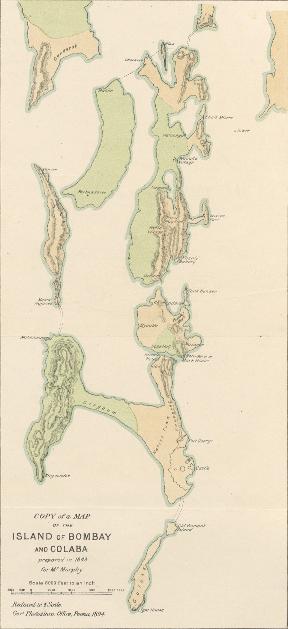
The geography of Mumbai in the early 18th century bore little resemblance to the contiguous metropolis of 2026. In 1700, the territory consisted of seven distinct, swamp-ridden islands: Colaba, Little Colaba (Old Woman's Island), Bombay, Mazagaon, Parel, Worli, and Mahim. These landmasses were separated by treacherous creeks and mudflats, rendering the area a breeding ground for malaria and cholera. The Portuguese, who held the territory before the British, viewed these islets as separate entities, a perspective that shifted only when engineering need forced a unification strategy. The most dangerous of these maritime gaps was the "Great Breach" between Worli and the northern ridge of Cumballa Hill, where the Arabian Sea rushed in with violence during high, submerging the central lowlands.
Governor William Hornby, who administered the presidency from 1771 to 1784, identified the Great Breach as the primary obstacle to the city's survival. The constant flooding turned the central area into a putrid swamp known as "The Flats," which separated the safe harbor of Bombay from the northern suburbs. In 1782, Hornby proposed a massive embankment to seal the breach. The Directors of the East India Company (EIC) in London, prioritizing profit over civil engineering, rejected the proposal as too expensive. Hornby, in a calculated act of insubordination, ignored the order. He authorized the construction of the embankment regardless, knowing his term would end before the Company could physically stop him.
The resulting structure, known as the Hornby Vellard (derived from the Portuguese vallado, meaning fence or embankment), was completed in 1784. The project cost approximately 100, 000 Rupees, a sum the EIC deemed exorbitant which history proves was a bargain for the land it created. The Vellard was not a road; it was a dam. By blocking the sea at Worli, it allowed the "Flats" (modern-day Tardeo, Byculla, and Mahalaxmi) to drain and solidify. This unauthorized engineering project welded the western islands together, creating the solid spine of the future city. The reclaimed land, yet, remained sea level in pockets, a geological fact that continues to plague municipal drainage systems in 2026.
Following Hornby's lead, the unification of the archipelago accelerated through a series of strategic causeways. The Sion Causeway, initiated in 1798 and completed in 1802 under Governor Jonathan Duncan, bridged the gap between the island of Bombay and Salsette in the north. Constructed at a cost of roughly 50, 370 Rupees, this causeway was initially narrow and required widening in 1826. It provided the permanent dry route for commerce to flow from the mainland, reducing the city's dependence on boat traffic for food supplies.
The southern consolidation occurred three decades later. The Colaba Causeway, completed in 1838, linked the main Bombay island to Little Colaba and Colaba proper. Before this connection, the southern tip was a military cantonment accessible only by ferry, which frequently capsized during the monsoon. The 1838 construction, engineered by the British administration, solidified the southern prong of the city, creating the continuous landmass that houses the Gateway of India and the primary administrative district. This project eliminated the separation that had defined the harbor's entrance for centuries.
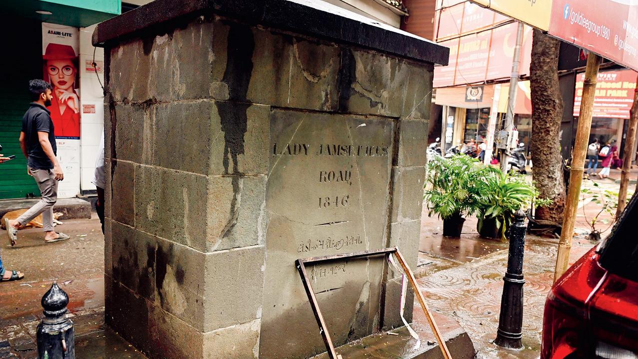
The final link in the seven-island chain was the Mahim Causeway, completed in 1845. Unlike the government-funded projects, this important connector was financed by private philanthropy. Lady Avabai Jamsetjee Jeejeebhoy, wife of the Baronet Sir Jamsetjee Jeejeebhoy, donated approximately 157, 000 Rupees to build the after the EIC refused to fund it. Her stipulation was that the government must never charge a toll for its use. This causeway connected Mahim to Bandra, merging the island city with the larger Salsette landmass and opening the northern corridor for the suburban expansion that would define 20th-century Mumbai.
The engineering methods used in these reclamations were crude by modern standards yet. Laborers filled the creeks with stone, rubble, and coconut tree trunks, topping them with mud and clay. This "cut and fill" technique altered the sedimentation patterns of the harbor. As the sea was shut out, the water table in the reclaimed areas remained high, and the soil composition remained unstable. The legacy of this 18th and 19th-century reclamation is a city built on soft clay, susceptible to shifting and sinking.
Key Reclamation Projects (1784, 1845)
Structure
Completion Year
Key Figure
Cost (Historical Rs)
Geography Connected
Hornby Vellard
1784
William Hornby
~100, 000
Worli to Bombay (sealed Great Breach)
Sion Causeway
1802
Jonathan Duncan
50, 370
Bombay to Salsette (North)
Colaba Causeway
1838
Robert Grant
Government funded
Bombay to Colaba (South)
Mahim Causeway
1845
Lady Jeejeebhoy
157, 000
Mahim to Bandra
Data from 2024 and 2025 indicates that the consequences of these early reclamations are becoming acute. Satellite radar interferometry studies published in Nature Sustainability (2025) reveal that Mumbai is sinking at an average rate of roughly 2mm per year, with specific reclaimed pockets subsiding at rates as high as 26. 1mm annually. The areas most affected, Byculla, Dadar, and parts of Worli, sit directly atop the "Flats" created by the Hornby Vellard. The weight of modern vertical construction on this artificial land compresses the soft marine clay beneath, accelerating the subsidence.
The Coastal Road project, nearing full operational status in 2026, mirrors the ambition of the Hornby Vellard on a grander. Just as Hornby ignored the EIC to seal the breach, modern planners have pushed forward with reclamation even with environmental warnings. The 18th-century engineering saved the city from the sea, yet it also trapped the city in a perpetual battle against drainage. The "saucer" shape of Mumbai, a direct result of joining raised islands with low-lying reclaimed flats, ensures that the monsoon floods of 2026 follow the exact geographic logic of the 1784 Great Breach.
Cotton Economics & The American Civil War Catalyst (1861, 1900)
Estuarine Reclamation Engineering & The Hornby Vellard (1784, 1845)
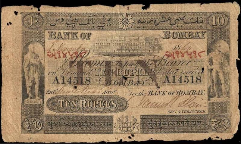
The trajectory of Bombay shifted violently in 1861, not due to local policy, because of a cannon shot at Fort Sumter in South Carolina. The American Civil War severed the supply of raw cotton to the textile mills of Lancashire, creating a sudden vacuum in the global market. Great Britain, dependent on the American South for 80 percent of its cotton, turned in desperation to its colony. Bombay, previously a secondary trading post, possessed the only port capable of shipping the "white gold" of the Deccan plateau at the necessary. The result was an economic injection of ferocity rarely seen in urban history. Between 1861 and 1865, the value of cotton exports from Bombay rose from roughly £5. 2 million to £35 million. The price of Indian cotton on the Liverpool market surged from 4 pence per pound to over 24 pence.
This influx of capital, estimated by financial historian D. E. Wacha at £81 million sterling, triggered a speculative mania that consumed the city. Merchants, traders, and even civil servants abandoned prudence for the stock market. The central figure of this financial delirium was Premchund Roychund, a broker who leveraged his position to float unparalleled ventures. The most notorious was the Back Bay Reclamation Company, formed to reclaim land from the sea. Shares with a face value of 5, 000 rupees traded at a premium of 50, 000 rupees at the height of the frenzy in 1864. The city was awash in liquidity; old mattresses were reportedly torn open to sell the cotton stuffing, and bullock carts transporting the fiber were guarded like bullion convoys.
The bubble burst with the same speed at which it inflated. The surrender of Confederate General Robert E. Lee in April 1865 signaled the return of American cotton to British ports. Prices in Bombay collapsed within weeks. The crash of 1865 wiped out the fortunes of the city's merchant elite, including Roychund. The Bank of Bombay, a Presidency bank entrusted with government funds, failed in 1866 due to reckless lending against speculative shares, a financial catastrophe that required a special legislative act to resolve. Yet, the wealth generated during those four years did not entirely. It had been transmuted into stone and infrastructure. The capital amassed during the boom funded the construction of the Victorian Gothic edifices that define the Fort district: the High Court, the University of Bombay, and the Secretariat.
Governor Sir Bartle Frere used the economic momentum to reshape the physical city. He ordered the demolition of the obsolete Fort walls in 1862, filling the stagnant moat to create wide boulevards and open spaces. This decision physically integrated the European commercial quarter with the "Native Town," ending the spatial segregation that had defined the island for a century. The ramparts were replaced by a contiguous urban fabric, allowing the city to breathe and expand. Frere's vision ensured that even after the financial ruin of 1865, the structural skeleton of a modern metropolis remained.
The opening of the Suez Canal in 1869 cemented Bombay's position as the "Gateway of India." The canal reduced the maritime distance between London and Bombay by approximately 4, 500 miles, cutting the voyage time from three months to less than a month. Bombay became the port of call for ships arriving from Europe, stripping Calcutta of its maritime primacy on the western method. Trade volumes surged, and the city's docks underwent massive expansion to accommodate the steamships that replaced sailing vessels. The Sassoon Dock, the wet dock in western India, opened in 1875, followed by the Prince's Dock in 1880 and the Victoria Dock in 1888.
Industrialization followed the trade boom. While the textile mill, the Bombay Spinning and Weaving Company, was established by Cowasji Nanabhoy Davar in 1854, the sector exploded in the 1870s and 1880s. By 1900, the city hosted 82 mills employing over 73, 000 workers. These mills drew waves of migration from the drought-prone Konkan region, swelling the population from 644, 405 in 1872 to over 821, 000 in 1891. The migrants settled in the Girangaon (Village of Mills) area, living in chawls, multi-story tenements with shared utilities that maximized density and profit for landlords.
The density proved fatal. In September 1896, the bubonic plague arrived in Bombay, likely carried by rats on ships from Hong Kong. The disease took hold in the grain markets of Mandvi, where the rat population thrived on stored food and poor sanitation. The death toll was catastrophic. In February 1897 alone, mortality peaked at 1, 900 deaths per week. Panic gripped the city; an estimated 400, 000 residents, nearly half the population, fled to the countryside, spreading the infection further. The colonial administration's initial response, forced hospitalization, segregation, and the destruction of property, incited riots and deep distrust among the Indian population.
The plague forced the British administration to acknowledge that public health was an engineering problem. In 1898, the government formed the Bombay City Improvement Trust (BIT), an organization with sweeping powers to reshape the urban. The BIT was tasked with ventilating the congested neighborhoods to "let the lungs of the city breathe." Its engineers cut broad avenues through the densest parts of the Native Town, most notably Princess Street and Sydenham Road ( Mohammedali Road). These projects involved the demolition of thousands of unsanitary dwellings, displacing the poor to the northern fringes of the island. The BIT also initiated the planned suburban schemes, developing Dadar, Matunga, and Sion to decongest the southern tip.
By the turn of the century, Bombay had endured a pattern of extreme volatility. It had been rich, then bankrupt; healthy, then pestilent. The American Civil War provided the capital, the Suez Canal provided the connectivity, and the plague provided the impetus for urban planning. The city that entered the 20th century was no longer a collection of islands a unified, industrial engine, built on a foundation of cotton, stone, and the graves of plague victims. The chaotic energy that defines modern Mumbai was forged in this crucible of 19th-century speculation and survival.
The Great Textile Strike & Industrial Deconstruction (1982)
The silence that fell over Girangaon in January 1982 was not the quiet of peace, the holding of breath before a suffocation. On January 18, trade union leader Dr. Datta Samant led approximately 250, 000 textile workers from 65 mills into an indefinite strike. The demand was a wage hike and the scrapping of the Bombay Industrial Relations Act, which bound workers to the singular, politically compliant Rashtriya Mill Mazdoor Sangh (RMMS). The strike, intended to force the hand of the Bombay Millowners' Association, instead handed them the weapon they had secretly coveted: a pretext to shut down unprofitable manufacturing units and unlock the astronomical value of the land beneath them. For eighteen months, the chimneys of Parel, Lalbaug, and Worli ceased to smoke. The Great Textile Strike became one of the largest industrial actions in world history, yet it ended in a catastrophic pyrrhic defeat for the labor force. By the time the strike officially withered in 1983, over 150, 000 workers had lost their employment. The mills did not reopen to churn cotton; they opened their gates to surveyors and real estate developers. The industrial geography of Mumbai, defined for a century by the rhythm of the loom, began a violent metamorphosis into a of finance and luxury consumption. The method of this transformation was codified in the Development Control Regulations (DCR), specifically Regulation 58. Introduced in 1991, the original rule mandated a "one-third" formula for redevelopment: one-third of the land for the mill owner, one-third for the Brihanmumbai Municipal Corporation (BMC) for open spaces, and one-third for the Maharashtra Housing and Area Development Authority (MHADA) for public housing. This formula, had it been enforced, would have gifted the suffocating city nearly 400 acres of parks and affordable homes. the real estate lobby, sensing a fortune in the "Golden Triangle" of central Mumbai, maneuvered for a loophole. In 2001, the state government amended DCR 58, subtly changing the definition of land to be shared from "total land" to "open land." Since most mill compounds were covered by structures, "open land" was negligible. This semantic sleight of hand reduced the public share of land to a fraction of the original intent. The Charles Correa Committee, appointed in 1996 to draft a plan for the mill lands, saw its recommendations for integrated urban planning discarded in favor of piecemeal, high-profit monetization. The physical manifestation of this policy is most visible at the Phoenix Mills site in Lower Parel. Once a spinning giant established in 1905, it morphed into High Street Phoenix and The Palladium, a complex of luxury retail and entertainment that bears no trace of its blue-collar ancestry save for a sanitized smokestack preserved as an aesthetic prop. By 2026, this precinct commands real estate prices exceeding ₹120, 000 per square foot, hosting global luxury brands where workers once fought for a monthly wage of ₹500. The distinct social fabric of the *chawls*, communal tenements that the Marathi theatre movement and the Dalit Panthers, was, replaced by gated high-rises that turned their backs to the street. The human cost of this deconstruction was a mass displacement of the *Girni Kamgar* (mill workers). Denied the housing promised to them on the mill lands, thousands were forced into the expanding slums of Dharavi or pushed to the distant peripheries of Kalyan and Virar. The "Singapores of Girangaon" rose on the graves of the industrial workforce. By 2025, the state government's sporadic lotteries for mill worker housing had provided homes to fewer than 20, 000 families, a token gesture against the hundreds of thousands displaced. The promised "revival" of the textile industry never materialized; instead, the capital generated from the land sales was funneled into the tertiary sector, cementing Mumbai's transition from a production hub to a service economy.
Impact of DCR 58 Amendment on Public Land Share (Estimated)
Metric
Original 1991 Formula (Total Land)
2001 Amended Formula (Open Land)
Basis for Division
Entire Mill Compound Area
Only Vacant Land (excluding structures)
Land to BMC (Open Space)
~133 acres
~32 acres
Land to MHADA (Housing)
~133 acres
~32 acres
Land to Mill Owners
~133 acres
~536 acres (including structures)
Public Loss
-
~200 acres lost to private development
In 2026, the redevelopment of the remaining "sick" mills and the associated chawls continues under the guise of urban renewal. The Maharashtra government's push to "fast-track" chawl redevelopment frequently results in vertical slums for the original tenants and luxury inventory for the open market. The textile era is a ghost, its history rewritten by the victors of the 1982 strike, not the union leaders, the land owners who realized that in Mumbai, the ground itself was more valuable than anything that could be produced upon it.
Suburban Railway Density & Commuter Mortality Statistics
Cotton Economics & The American Civil War Catalyst (1861, 1900)
The Mumbai Suburban Railway operates under a condition officially classified by Indian Railways as "Super Dense Crush Load." This engineering term describes a passenger density of 14 to 16 standing persons per square meter of floor space, a ratio that defies standard safety used in global transit systems. While a standard nine-car rake carries a rated capacity of 1, 700 passengers, peak hours in Mumbai see these same trains transporting over 4, 500 individuals. This compression results in a physical environment where commuters are frequently pinned in fixed positions for up to two hours, unable to move their limbs, relying on the shared pressure of the crowd to remain upright. The structural limits of the carriages are tested daily, with the center of shifting dangerously as hanging commuters, known locally as "footboard travellers", cling to the exterior grab poles.
The origins of this transit emergency trace back to the mid-19th century. The Great Indian Peninsula Railway (GIPR) ran the passenger train in Asia from Bori Bunder to Thane on April 16, 1853. Yet, the true precursor to the modern suburban crush was the electrification of the network. On February 3, 1925, the electric train ran on the Harbour Line, followed by the electrification of the Bombay, Baroda and Central India Railway (BB&CI) Western line in 1928. This technological shift from steam to 1, 500V DC traction allowed for higher frequency and faster acceleration, essential for a linear city growing northward. By the time the network converted to 25kV AC traction in the early 21st century to improve efficiency, the population growth had already outpaced infrastructure gains by a magnitude of three to one.
Mortality statistics on this network present a grim accounting of urban neglect. Between 2004 and 2024, over 51, 000 commuters died on the suburban tracks. This figure exceeds the casualties of prolonged military conflicts. The Government Railway Police (GRP) data for 2024 recorded 2, 468 deaths, a slight decrease from the 2, 590 fatalities in 2023. By early 2026, reports indicated a further marginal dip to 2, 287 deaths for the year 2025. Even with this reduction, the system averages roughly six to seven fatalities daily. The primary causes remain consistent: trespassing (crossing tracks due to insufficient footbridges) accounts for nearly 50% of these deaths, while falling from running trains constitutes approximately 20-25%. The "gap trap", the lethal space between the train footboard and the platform, continues to claim lives, particularly at stations with curved platforms like Sion and Mumbra.
The geography of death on the network is not uniform. The Thane-Kalyan section on the Central Line and the Borivali-Virar stretch on the Western Line consistently record the highest mortality rates. As real estate prices pushed the working class further north into the Mumbai Metropolitan Region (MMR), the travel distance increased, as did the desperation to board the available train. In 2025, the Thane section alone reported 278 fatalities, followed closely by Kalyan with 266. These numbers reflect a widespread failure to integrate housing policy with transport planning. The "Virar Fast" is not a train service; it is a survival contest where boarding at peak hours requires distinct physical techniques passed down through generations of commuters.
A defining moment in the history of this negligence occurred on September 29, 2017, at the Elphinstone Road ( Prabhadevi) station. A stampede on a narrow, decades-old foot overbridge (FOB) resulted in 23 deaths and 39 injuries. The tragedy was triggered by a sudden downpour and a deadly misunderstanding, a rumor that the was collapsing, exacerbated by the confusion between the Marathi word for flowers ("phool") and the English word "pull." The inquiry committee headed by the Western Railway Chief Safety Officer exposed deep fractures in station management. The was known to be insufficient for years, yet bureaucratic lethargy delayed its replacement. The incident forced a reactive audit of all suburban stations, leading to the rapid construction of new FOBs by the Indian Army and the Mumbai Railway Vikas Corporation (MRVC).
By 2026, the daily ridership of the suburban network inched toward the 10 million (1 crore) mark, with the Central Railway alone carrying over 6. 2 million passengers on weekdays. The introduction of air-conditioned (AC) locals with automatic doors provided a safety solution for a fraction of the populace introduced a new class divide. The closed doors prevent falls, yet the limited number of AC services means the vast majority of the 3, 000+ daily services remain open-door death traps. The Mumbai Urban Transport Project (MUTP) 3A aimed to mitigate this by expanding capacity, the pace of execution lags behind the relentless surge in demand.
The economic cost of this mortality is rarely calculated in state budgets, the social impact is devastating. The loss of a primary breadwinner in a railway accident frequently pushes lower-middle-class families into immediate poverty. Compensation claims are frequently contested by the Railways under the "untoward incident" clause, leading to years of litigation for grieving families. The "trespass control" projects, which include building concrete walls along tracks to prevent crossing, achieved 98% completion by late 2025. This physical hardening of the corridor reduced track-crossing deaths in specific zones, yet the core problem of crush density remains unsolved.
The "pole hit" phenomenon is another gruesome metric unique to this system. Commuters hanging outside the train frequently strike trackside signal poles or overhead equipment structures. The clearance between the track center and these structures is minimal, designed for trains with closed doors, not for rakes with human bodies extending two feet beyond the threshold. In 2024, over 14 deaths were attributed to passengers falling into the gap between the train and platform, a specific failure of platform engineering where the height and distance do not align with the rake dimensions. The raising of platform heights, a project undertaken between 2015 and 2020, reduced these incidents did not eliminate them.
Modernization efforts, such as the implementation of the Communication Based Train Control (CBTC) system, pledge to reduce the headway between trains from three minutes to 2. 5 minutes. This theoretical increase in frequency aims to lower the passengers per square meter from 16 to 12. Yet, historical data shows that every increase in capacity is immediately absorbed by latent demand. The Vande Metro initiatives and the expansion of the Metro rail network (Lines 2A, 7, and 3) were intended to decongest the suburban rails. Data from early 2026 suggests a complex outcome: while Metro ridership hit record highs, the suburban rail ridership did not decline proportionally. Instead, the Metro served a new demographic or induced new trips, leaving the "local" as the only viable option for the long-distance workforce commuting from Karjat, Kasara, and Virar.
The psychological toll on the motormen (train drivers) is an underreported aspect of this system. A motorman on the Mumbai suburban network witnesses an average of one suicide or accident fatality every month. The trauma of seeing a commuter crossing the tracks, applying the emergency brakes, and knowing the physics of the train not allow it to stop in time, creates a high rate of PTSD among operating staff. This human cost extends from the tracks to the cab, creating a pattern of stress that permeates the entire operational hierarchy.
The transformation of Dharavi from a mangrove-choked fissure between islands to the most densely populated habitation on Earth is a study in unintended urban consequences. While the 18th-century Hornby Vellard sealed the Great Breach, it was the colonial administration's sanitary policies of the late 19th century that populated this terrain. In 1887, the British government expelled the polluting tannery industry from the peninsular city center to the "northern fringe" of Dharavi. This expulsion, driven by the fear of miasma and disease following the cholera epidemics, forced Tamil Muslim tanners and Gujarati potters (Kumbhars) to settle on the marshy edges of the Mahim Creek. By 2026, this zone, once considered a peripheral dumping ground, sits as the geographic heart of the Mumbai metropolis, occupying prime real estate valued in excess of ₹20, 000 crore.
The Slum Rehabilitation Authority (SRA), established in December 1995 following the recommendations of the Afzalpurkar Committee, formalized the method of "cross-subsidy" that defines Mumbai's housing policy. The model is deceptively simple: private developers are granted high Floor Space Index (FSI) incentives to build vertical towers on slum land. A portion of the new construction is given free to "eligible" slum dwellers, while the remainder, the sale component, is sold at market rates to subsidize the project and generate profit. In practice, this system has frequently degenerated into a pattern of corruption, stalled projects, and displacement. By 2025, the SRA had identified 517 stalled projects across the city, with 86 classified as "dead" due to developer insolvency or fraud, leaving thousands of families in transit camps for decades.
Dharavi's redevelopment represents the SRA model scaled to an industrial magnitude. After repeated failed tenders since 2004, the Maharashtra government awarded the project to the Adani Group in late 2022 for a bid of ₹5, 069 crore. The project, executed through a Special Purpose Vehicle known as the Dharavi Redevelopment Project Pvt Ltd (DRPPL), holds an 80% stake for Adani and 20% for the state government. The financial engine of this deal is not the sale of apartments within Dharavi, the generation of Transferable Development Rights (TDR). The developer earns TDR certificates for the free housing provided, which can then be sold or used to build luxury high-rises elsewhere in Mumbai, monetizing the slum's density across the entire city grid.
The metrics of Dharavi in 2026 present a logistical nightmare that defies standard urban planning. Spanning approximately 2. 39 square kilometers (roughly 590 acres), the area houses a population estimated between 600, 000 and 1. 2 million, creating a population density that peaks at over 350, 000 people per square kilometer, nearly ten times that of Manhattan. The informal economy, comprising leather tanning, pottery, textile recycling, and plastic processing, generates an estimated annual turnover of $1 billion. This economic engine relies on the horizontal, ground-level interconnectivity of the slum structures, a feature that vertical rehabilitation towers threaten to obliterate. The 2024-2026 survey, conducted by DRPPL, used "Digital Twin" technology to map over 85, 000 tenements, yet the results have sparked fierce resistance regarding eligibility.
The definition of "eligible" remains the central point of conflict in the 2026 redevelopment phase. Under the current SRA guidelines, only residents who can prove their domicile prior to January 1, 2000, are entitled to a free 350-square-foot apartment within Dharavi. Those who arrived between 2000 and 2011 are relegated to "rental housing" or purchase options, frequently located outside the prime zone. The vast population that arrived after 2011, frequently the poorest laborers sustaining the city's service sector, face total exclusion. In August 2025, the Supreme Court upheld the use of 150 acres of salt pan land in Mulund for rehabilitating these "ineligible" residents, a move that critics amounts to a state-sanctioned purge of the poor from the city center to the ecological margins.
By March 2026, the physical of Dharavi has commenced, starting with 6. 5 acres of railway land. The DRPPL has secured additional land parcels in Malad (118 acres) and the Deonar dumping ground to house the displaced. The sociopolitical friction is palpable; the "Navi Dharavi" proposed for Mulund and the salt pans is viewed by urban planners as the creation of new, vertical ghettos from the economic networks that allowed the original Dharavi to survive. The SRA's track record offers little comfort: between 2022 and 2025, the state met only 25% of its slum rehabilitation, completing just 37, 560 tenements against a goal of 150, 000. The consolidation of the Dharavi project under a single conglomerate raises serious questions about monopoly control over Mumbai's land bank and the fate of the 700, 000 residents likely to be deemed ineligible for in-situ rehabilitation.
Prime land located at the intersection of Western and Central Railways.
Population Density
~350, 000+ per sq km
Among the highest globally; 10x Mumbai's average density.
Adani Bid Value (2022)
₹5, 069 Crore ($610 Million)
Initial investment; total project revenue chance estimated at ₹20, 000+ Crore.
Eligibility Cutoff (Free)
January 1, 2000
Residents prior to this date get 350 sq ft in-situ unit.
Eligibility Cutoff (Paid/Rent)
Jan 1, 2000 , Jan 1, 2011
Relocated to Mulund, Malad, or Salt Pans (approx. 10-15km away).
Ineligible Population
Est. 40%, 50% of residents
Post-2011 arrivals or those absence documentation; face eviction or distant relocation.
SRA Stalled Projects (2025)
517 Projects (86 "Dead")
Evidence of widespread failure in the developer-led rehabilitation model.
Informal Economy Output
~$1 Billion USD Annually
Recycling, leather, pottery; at risk of destruction due to zoning changes.
Relocation Lands (2026)
Mulund Salt Pans (150 acres), Malad (118 acres)
Use of ecologically sensitive salt pans approved by SC in 2025.
The "slum-free Mumbai" slogan to a "poor-free city center." The financial mechanics of the Dharavi project rely on the extraction of value from the land, not the welfare of the inhabitants. By converting horizontal density into vertical FSI, the state and the developer unlock trillions of rupees in real estate value. The cost is paid by the "ineligible" citizen, who is pushed to the salt pans of Mulund, repeating the pattern of 1887 where the unwanted were cast out to the northern fringe. In 2026, the fringe has simply moved further north, the logic of exclusion remains absolute.
Financial District Capital Flow & GDP Contribution (1991, 2025)
The Great Textile Strike & Industrial Deconstruction (1982)
The financial architecture of Mumbai is not a product of the 1991 liberalization; it is the result of three centuries of aggressive capital accumulation, beginning with the opium and cotton trades of the 1700s and 1800s. While the Seven Islands were physically stitched together by the Hornby Vellard, their economic unification was forged by the merchant princes, Jamsetjee Jejeebhoy, David Sassoon, and Premchand Roychand, who utilized the port's strategic geography to monopolize trade with China and Lancashire. yet, the modern financial colossus that Mumbai represents in 2026 emerged from the rupture of 1991, when India dismantled the License Raj, transforming the city from a constrained trading post into a global capital clearinghouse.
The trajectory of Mumbai's capital flow between 1991 and 2026 reveals a clear centralization of India's monetary velocity. Following the establishment of the National Stock Exchange (NSE) in 1994 to break the clubby hegemony of the Bombay Stock Exchange (BSE), the city became the undisputed arbiter of India's corporate value. By March 2026, the market capitalization of companies listed on the BSE crossed the $5 trillion threshold, a figure that exceeds the GDP of most G7 nations. This valuation explosion was not distributed evenly; it concentrated wealth physically within the Mumbai Metropolitan Region (MMR), creating a feedback loop where capital chased capital. The city's contribution to India's exchequer remains disproportionate to its population. In the fiscal year 2024, 25, Maharashtra contributed approximately ₹7. 61 trillion in direct taxes, accounting for 40. 4% of the national total among states, with Mumbai alone generating nearly 30% of India's total income tax collections. This fiscal extraction funds the central government's operations, yet the return on investment in municipal infrastructure remained a point of friction until the debt-fueled capex pattern of the 2020s.
The geography of this capital has shifted. For decades, the "Golden Quadrilateral" of Nariman Point commanded the highest office rentals in the world, surpassing Midtown Manhattan in the mid-1990s. This monocentric model collapsed under the weight of congestion and the obsolescence of the Art Deco and Brutalist towers of South Mumbai. The establishment of the Bandra-Kurla Complex (BKC) on marshy land along the Mithi River marked the migration of the financial nerve center. By 2025, BKC commanded rents exceeding ₹900 per square foot, housing the headquarters of global banks, the NSE, and the diamond bourse. Yet, a curious reversal occurred between 2024 and 2026: the completion of the Coastal Road revitalized Nariman Point, driving a 52% surge in rental yields as hedge funds and legal firms returned to the historic district, creating a dual-core financial system.
Foreign Direct Investment (FDI) data confirms Mumbai's role as the primary gateway for global liquidity entering India. In FY 2024, 25, Maharashtra attracted 39% of India's total FDI equity inflows, amounting to over $19 billion in a single fiscal year. This dominance even with the rise of Gujarat's GIFT City, which attempted to siphon off offshore financial services. While GIFT City captured specific derivatives markets, Mumbai retained the core equity, debt, and private equity syndication desks. The "Mumbai Premium", the extra cost of doing business in the city, is paid by global capital because the agglomeration of talent, legal frameworks, and regulatory bodies (RBI, SEBI) creates an ecosystem that remote hubs cannot replicate.
Table 6. 1: Mumbai Financial Metrics & Capital Density (1991 vs. 2025)
Economic Indicator
1991 Statistics
2025-2026 Statistics
BSE Market Capitalization
~$40 Billion
~$5. 0 Trillion
Direct Tax Contribution (National Share)
~22%
~30. 5%
Prime Office Rent (Inflation Adjusted)
₹85/sq ft (Nariman Point)
₹1, 000+/sq ft (BKC Premium)
FDI Inflow Share (Maharashtra)
<10%
39% (FY25)
Daily Stock Turnover (Avg)
₹300 Crore
₹1, 00, 000+ Crore (Cash + Derivatives)
The GDP contribution of the Mumbai Metropolitan Region (MMR) is estimated at $310 billion (nominal) as of 2025, representing roughly 6. 16% of India's national GDP. This figure, yet, understates the city's strategic importance. Mumbai controls 70% of the country's maritime trade and 90% of its stock market assets. The velocity of money in Mumbai is accelerated by the density of its clearing systems; a rupee traded in Mumbai circulates through the banking system three times faster than in the hinterland. The risks to this dominance in 2026 are no longer just regional competition infrastructural collapse. The city's debt load, incurred to finance the Metro Line 3 and the Trans-Harbour Link, requires sustained economic growth of 7. 9% per annum to service. If the global liquidity tap tightens, Mumbai's highly leveraged real estate and infrastructure markets face serious exposure.
Organized Crime Syndicates & The Real Estate Nexus
The transformation of Mumbai from a colonial trading post to a vertical concrete jungle is a narrative written in blood, cement, and Floor Space Index (FSI). By 2026, the distinction between organized crime syndicates and legitimate real estate developers has eroded to the point of invisibility. This nexus did not emerge overnight; it is the result of a fifty-year evolution where the underworld shifted its primary commodity from contraband gold to the scarcity of land itself. In a city where geography is the constraint, the control of square footage became more lucrative than narcotics or extortion. The roots of this convergence lie in the 1970s. During this period, the underworld, dominated by figures like Haji Mastan, Karim Lala, and Varadarajan Mudaliar, focused on smuggling and dockyard theft. Land disputes were incidental, settled by muscle rather than widespread acquisition. Yet, the seeds were sown when the Urban Land (Ceiling and Regulation) Act of 1976 created an artificial scarcity of developable land. Gangsters realized that "protection" could extend to squatters and landlords alike. By the mid-1980s, the Dawood Ibrahim gang, known as D-Company, began investing illicit proceeds into construction projects, recognizing that real estate offered the perfect laundromat for black money. The violent turning point arrived in the 1990s with the closure of the city's textile mills. The 600 acres of prime land in Girangaon (the Village of Mills) became the battlefield for the "Mill Land Wars." The murder of Sunit Khatau in May 1994 marked the definitive entry of the mafia into corporate real estate. Khatau, the owner of Khatau Mackanji Mills, was gunned down in his Mercedes at a traffic signal near the Mahalaxmi Race Course. He had planned to sell a 13-acre plot in Byculla for an estimated ₹300 crore, a deal that attracted the attention of rival gangs led by Amar Naik and Arun Gawli. The gangs demanded a cut of the sale price, frequently as 5% or more, in exchange for "clearing" the land of workers and unions. Three years later, the assassination of trade union leader Datta Samant in January 1997 confirmed that the old order of labor rights was being liquidated to make way for high-rises. Samant, who staunchly opposed the sale of mill lands without worker rehabilitation, was shot outside his Powai residence. Investigations pointed to the Chhota Rajan gang, acting at the behest of interests desperate to unlock the immense value of the mill lands. These murders were not random acts of violence; they were business transactions, removing the human obstacles to capital accumulation. The introduction of the Slum Rehabilitation Authority (SRA) scheme in 1995 provided the underworld with a quasi-legal framework to seize land. The SRA model, intended to provide free housing to slum dwellers in exchange for development rights, became a playground for the mafia. Gangsters reinvented themselves as "developers" or "consultants," using coercion to obtain the consent of slum residents. They inflated the number of eligible tenants to generate extra FSI, which was then sold on the open market for thousands of crores. The Patra Chawl scam, which unraveled in the early 2020s, exemplifies this sophisticated looting machine. The project involved the redevelopment of a 47-acre plot in Goregaon, home to 672 tenants. Guru Ashish Construction, a subsidiary of HDIL, sold the FSI to nine different developers for ₹901 crore without constructing a single rehabilitation flat for the original tenants. The Enforcement Directorate (ED) investigation revealed that proceeds of crime were funneled through shell companies and used to purchase land parcels in Alibaug and other districts. By 2026, the legal proceedings continue, yet the physical displacement of the families remains a permanent scar on the city's demographics. In the post-2010 era, the nexus underwent a "corporatization." The street-level violence of the 1990s was replaced by white-collar crime. Gangsters no longer needed to shoot builders; they became partners. The case of Iqbal Mirchi, a close aide of Dawood Ibrahim, illustrates this shift. Mirchi acquired prime properties across Mumbai, including Ceejay House in Worli and the New Roshan Talkies in Grant Road, using proceeds from narcotics trafficking. Even after his death in 2013, his family continued to derive income from these assets. In January 2025, the ED was forced to take physical possession of the New Roshan Talkies plot after Mirchi's associates demolished the structure in a brazen attempt to sell the vacant land even with a standing attachment order. The of extortion also evolved. By 2024, the threat of violence had been supplemented by the threat of regulatory action. A new breed of extortionists emerged who impersonated officials from central agencies like the ED. In early 2024, the Mumbai Crime Branch arrested a syndicate that demanded ₹164 crore from a developer, threatening him with a money-laundering investigation if he refused to pay. This "ED extortion" racket signaled a dangerous fusion of criminal intent with the fear of state. The following table details key events where the trajectory of Mumbai's real estate market intersected violently with organized crime.
The Price of Blood: Key Real Estate Murders & Asset Seizures (1994, 2025)
Year
Event / Case
Location
Financial Implication / Asset Value
Syndicate / Key Players Involved
1994
Murder of Sunit Khatau
Mahalaxmi / Byculla
₹300 Crore (Est. Land Value)
Amar Naik Gang, Arun Gawli Gang
1997
Murder of Datta Samant
Powai
N/A (Obstruction to Mill Sales)
Chhota Rajan Gang
1997
Murder of Vallabhbhai Thakkar
Raghuvanshi Mills
Undisclosed Extortion Demand
Arun Gawli Gang (Sada Pawle)
2020-22
Patra Chawl Scam Exposure
Goregaon
₹1, 039 Crore (Proceeds of Crime)
Pravin Raut, HDIL, Political Nexus
2024
"ED Extortion" Racket Bust
Bandra / Santacruz
₹164 Crore Demand
Omkar Developers Case (Impersonators)
2025
Seizure of New Roshan Talkies
Grant Road
₹500+ Crore (Mirchi Portfolio)
Iqbal Mirchi Family, D-Company
2025
Auction of Dawood Properties
Ratnagiri / Mumbai
₹2 Crore (Single Plot Sale)
SAFEMA Authority vs. D-Company
By March 2026, the influence of the underworld on Mumbai's real estate is less visible more widespread. The "gangster" has been replaced by the "aggregator", intermediaries who specialize in clearing title deeds, managing slum consent, and navigating the labyrinthine approval process of the BMC and SRA. These aggregators frequently operate with the backing of overseas syndicates, ensuring that the flow of black money into Mumbai's skyline remains uninterrupted. The auction of Dawood Ibrahim's ancestral properties in late 2025 provided a grim coda to this history. While the government successfully auctioned small agricultural plots in Ratnagiri, the major commercial properties in Mumbai linked to D-Company remain mired in litigation or are held by proxies. The inability of the state to fully monetize these seized assets points to the enduring fear the syndicate commands. chance bidders frequently withdraw, aware that a title deed from the government offers little protection against a call from Karachi or Dubai. The real estate market of Mumbai, therefore, cannot be understood solely through the lens of economics or urban planning. It is a sector where the price per square foot includes a premium for protection, political patronage, and the silence of displaced tenants. The gleaming towers of Lower Parel and the sprawling slum rehabilitation projects of the suburbs stand as monuments to a pact between capital and crime, a pact that has defined the city's physical form for over three decades. The violence has moved from the streets to the boardrooms, the underlying logic of force remains the city's governing principle.
The 2005 Deluge & Mithi River Encroachment Data
Suburban Railway Density & Commuter Mortality Statistics
The catastrophe of July 26, 2005, redefined Mumbai's relationship with its own geography. On that Tuesday, a cloudburst centered over the northern suburbs dumped 944 millimeters of rainfall within 24 hours, a figure that shattered the previous record of 575 millimeters set in 1974. The Santacruz observatory recorded the bulk of this precipitation, while Colaba in the south received only 73 millimeters, creating a localized hydraulic shock that the city's drainage infrastructure could not absorb. The deluge coincided with a high of 4. 48 meters at 2: 30 PM, which locked the storm water outgates and forced the runoff from the overflowing Vihar and Powai lakes to back up into the city. Official state records confirm 1, 094 fatalities across Maharashtra, with Mumbai city accounting for over 500 of these deaths, due to drowning in submerged vehicles or landslides in shantytowns.
Investigative analysis of the 2005 flood reveals that the disaster was not meteorological the result of systematic hydraulic strangulation. The Mithi River, a 17. 8-kilometer watercourse that originates at Vihar Lake and empties into the Arabian Sea at Mahim Creek, served as the primary failure point. Historical maps from the 1700s depict the Mithi as a strong seasonal river and estuary system capable of buffering monsoon surges. By 2005, urban planners had reduced this important artery to a fetid "nallah" (drain). The river's width, originally varying between 40 and 100 meters, had been constricted to less than 20 meters in serious stretches due to aggressive reclamation for the Bandra-Kurla Complex (BKC) and unchecked slum proliferation.
The most egregious engineering violation occurred at the Chhatrapati Shivaji Maharaj International Airport (CSIA). To accommodate the extension of the main runway (09/27), the Airports Authority of India (AAI) forced the Mithi River into a 90-degree turn and channeled it through a culvert beneath the tarmac. In July 2005, this culvert measured only 27 meters in width, creating a severe bottleneck against a flow volume requiring at least 60 to 100 meters of clearance. This artificial dam caused the river to swell upstream, submerging the suburbs of Kurla, Kalina, and Saki Naka under meters of water. The reclamation of the Mahim wetlands to build the BKC business district further eliminated the river's natural floodplains, removing the sponge method that historically absorbed excess and storm water.
Mithi River & 26/7 Flood Data: 2005 vs. 2026 Status
Metric
2005 Event / Status
2024-2026 Status
24-Hour Rainfall
944 mm (Santacruz)
Recurring high-intensity spells (e. g., 300mm+)
Mithi River Width (Airport)
27 meters (Bottleneck)
Widened to ~51 meters (Insufficient buffer)
Pollution (BOD Level)
High (Untreated Sewage)
80, 108 mg/L (Safe limit: 3 mg/L)
BRIMSTOWAD Project Cost
₹1, 200 Crore (Est.)
₹4, 000+ Crore (Escalated/Delayed)
Economic Loss
₹550 Cr (Insured) / ₹13, 500 Cr (Total)
Est. ₹20, 000 Cr risk for repeat event
Following the disaster, the state appointed the Madhav Chitale Committee to examine the causes and recommend solutions. The 2006 report was scathing. It mandated the immediate widening of the Mithi River, the deepening of its bed, and the creation of a 50-meter "No Development Zone" (NDZ) on both banks. The committee also called for the removal of encroachments and the restoration of the river's natural course where possible. Yet, two decades later, implementation remains fragmentary. While the Mumbai Metropolitan Region Development Authority (MMRDA) and the Brihanmumbai Municipal Corporation (BMC) claim to have widened the river to 60 meters in the lower reaches, the 50-meter buffer zone remains a fiction. Satellite imagery from 2025 shows fresh encroachments and concrete retaining walls built directly along the water's edge, turning the river into a concrete canal with zero ecological function.
The Brihanmumbai Storm Water Disposal System (BRIMSTOWAD) project, revived urgently after 2005, exemplifies the administrative lethargy Mumbai's flood defense. Originally estimated at ₹1, 200 crore, the project cost ballooned to over ₹4, 000 crore by 2024 due to delays in land acquisition and contractor disputes. Key components, such as the Mahul and Mogra pumping stations, faced years of stalling. The Mogra station, essential for draining the Andheri subway and surrounding lowlands, remained unbuilt for nearly 17 years after the deluge due to litigation over land ownership. Consequently, areas like Milan Subway and Hindmata continue to witness chronic waterlogging during moderate rainfall, the billions of rupees ostensibly spent on mitigation.
Ecological data from 2024 to 2026 indicates that the Mithi River remains a toxic hazard rather than a flood control asset. The Maharashtra Pollution Control Board (MPCB) consistently categorizes the river's water quality as "Bad to Very Bad." Biochemical Oxygen Demand (BOD) levels frequently exceed 80 mg/L, and have spiked to 210 mg/L, far surpassing the safe limit of 3 mg/L. This toxicity proves that the river continues to receive millions of liters of untreated industrial effluent and raw sewage daily. The "river" is a septic tank that runs through the heart of the financial capital. even with the allocation of ₹3, 941 crore for river rejuvenation under various civic budgets, the on-ground reality shows minimal improvement in water quality or hydraulic capacity.
The legacy of the 2005 deluge is a pattern of reactive spending and proactive failure. The city's drainage network, designed by the British in the early 20th century for a rainfall intensity of 25 millimeters per hour, was upgraded under BRIMSTOWAD to handle 50 millimeters per hour. Yet, weather patterns in the 2020s frequently deliver rain intensities exceeding 80 to 100 millimeters per hour. The refusal to restore the Mithi's natural floodplains, paired with the continued concreting of the estuary at Mahim, guarantees that Mumbai remains perilously to the high-intensity cloudburst.
Mumbai Trans Harbour Link & Connectivity Shifts (2024, 2026)
The inauguration of the Mumbai Trans Harbour Link (MTHL), officially named Atal Setu, on January 12, 2024, marked the definitive end of Mumbai's three-century struggle against its own geography. If the Hornby Vellard of the 18th century fused seven islands into one, the MTHL fused that island city to the mainland, ending the era where the Thane Creek served as a moat against expansion. Yet, as of March 2026, this engineering colossus presents a complex paradox: it is a triumph of construction a puzzle of utilization. The stands as a 21. 8-kilometer correction to the colonial error of developing Mumbai on a north-south axis, yet the traffic data from its two years of operation exposes a friction between infrastructure ambition and economic reality.
The engineering specifications of the MTHL demand scrutiny, not for their grandeur, for the of resource consumption they represent. Constructed at a cost of approximately ₹17, 843 crore, the consumes 17 times the steel used in the Eiffel Tower and concrete sufficient to build the Statue of Liberty six times over. It uses Orthotropic Steel Deck (OSD) technology for spans up to 180 meters, a need to navigate the complex maritime traffic of the Jawaharlal Nehru Port Trust (JNPT) and the sensitive mudflats of Sewri. This structure is not a road; it is a hardened artery designed to withstand the corrosive saline atmosphere for a century. The reduces the physical distance between Sewri in South Mumbai and Chirle in Raigad from a grueling two-hour loop to a twenty-minute sprint. yet, the reduction in time has not immediately translated into the projected volume of mass transit.
Traffic statistics from the Mumbai Metropolitan Region Development Authority (MMRDA) for the period between January 2024 and January 2025 reveal a clear variance between projection and performance. Initial feasibility reports estimated a daily volume of 40, 000 to 56, 000 vehicles in the opening year. The actual daily average settled at approximately 22, 689 vehicles. By early 2026, this number crept upward remained well the 70, 000-mark required for optimal financial recovery. The primary deterrent remains the toll pricing. At ₹250 for a single journey, the cost acts as a formidable filter, segregating the user base. Data indicates that over 91% of the traffic consists of private cars, turning the into a premium corridor for the affluent while the working-class mass transit continues to choke on the old Vashi. The MTHL, in its current operational phase, functions less as a public utility and more as a luxury bypass.
The connectivity equation shifted radically on December 25, 2025, with the commencement of commercial operations at the Navi Mumbai International Airport (NMIA). Inaugurated by Prime Minister Narendra Modi in October 2025, the airport's activation provided the missing demand driver for the MTHL. For the 23 months of the 's life, it connected a congested city to a developing hinterland., it connects the financial center to an active aviation hub. Early data from the quarter of 2026 shows a 15% spike in MTHL usage, driven specifically by airport-bound traffic from South Mumbai. The airport, currently operating domestic routes with carriers like IndiGo and Akasa Air, is scheduled to to full 24-hour international operations by mid-2026. This synchronization of the and the airport is the linchpin of the "Third Mumbai" concept, a planned urban agglomeration in the Ulwe-Panvel belt designed to decongest the island city.
even with the maritime link, the terrestrial integration on the Mumbai side remains a point of severe friction. The Worli-Sewri Elevated Connector, intended to feed traffic from the western coast directly onto the MTHL, missed its 2025 completion. As of March 2026, the project is approximately 70% complete, with a revised target of late 2026. Until this 4. 5-kilometer connector is operational, commuters from Worli, Bandra, and the western suburbs must navigate the clogged arteries of Parel and Prabhadevi to reach the MTHL entrance at Sewri. This "last-mile" failure undermines the efficiency of the sea link; a twenty-minute bay crossing is frequently preceded by a forty-minute struggle to reach the ramp. The delay highlights a recurring widespread flaw in Mumbai's planning: the dissonance between the execution of mega-projects and the completion of their feeder networks.
The real estate markets in Raigad have reacted to these developments with speculative ferocity. Property prices in Ulwe, once a dormant node, surged from ₹8, 500 per square foot in 2023 to over ₹13, 500 per square foot by early 2026. The Navi Mumbai Airport Influence Notified Area (NAINA) is witnessing a land rush comparable to the mill-land redevelopment of the early 2000s. Developers are marketing " -to-airport" proximity, betting on the eventual saturation of the MTHL. yet, this growth brings the risk of a chaotic urban sprawl. Unlike the planned nodes of Vashi or Nerul, the peripheral development in Chirle and Panvel risks outpacing the installation of sewage, water, and power infrastructure, chance replicating the unplanned density of Mumbai's northern suburbs.
Historical context renders the MTHL's 2024 arrival even more poignant. The concept of a cross-harbour link was formally proposed in the Wilbur Smith Report of 1963. Smith, a traffic engineer, foresaw that Mumbai's linear growth was unsustainable and recommended the "Uran " to open the mainland. For fifty-three years, the project languished in bureaucratic stasis, a victim of political indecision and funding disputes. It was only revived in 2015 under the Fadnavis administration, which secured funding from the Japan International Cooperation Agency (JICA). The six-decade delay came at a catastrophic cost: had the been built in the 1970s or 80s, the demographic pressure on Mumbai's local trains and slums might have been redistributed to the mainland before the population density reached serious mass.
The environmental trade-off for this connectivity is visible in the mudflats of Sewri. The region is a serious wintering ground for Lesser Flamingos. While the MMRDA implemented noise blocks and "silent" construction methods to mitigate impact, environmental watchdogs reported disturbances in bird migration patterns during the peak construction years (2018, 2023). The long-term ecological impact of placing a concrete behemoth through a sensitive estuarine ecosystem remains under study. The piers alter the hydrodynamics of the creek, chance affecting sedimentation rates and the mangrove cover that protects the shoreline from. In the rush to secure economic velocity, the ecological stability of the Thane Creek remains a variable that engineering calculations cannot fully control.
As 2026 progresses, the MTHL sits at a juncture. It is a piece of -world infrastructure grafted onto a city still battling third-world connectivity problem at its access points. Its financial viability depends heavily on the rapid maturation of the NMIA zone and the completion of the Worli-Sewri connector. Until the toll becomes affordable for the middle class or the feeder roads clear, the Atal Setu remain a spectacular symbol of chance rather than a fully utilized asset of the public. The shift is undeniable, the center of is moving east, the friction of transition proves that steel and concrete alone cannot solve the tangled urban legacy of Mumbai.
The engineering ambition that birthed the Hornby Vellard in the 18th century found its aggressive modern successor in the Mumbai Coastal Road Project (MCRP). While Governor Hornby fought the sea to unite seven islands for survival, the municipal authorities of the 21st century pushed back the Arabian Sea to accommodate the private automobile. By March 2026, the southern phase of this infrastructure behemoth, stretching 10. 58 kilometers from the Princess Street Flyover to the Worli end of the Bandra-Worli Sea Link, stood fully operational. The project, with a final price tag exceeding ₹14, 000 crore, represents the most significant alteration to Mumbai's shoreline since the Back Bay reclamation of the 1920s. Yet, the creation of this eight-lane freeway required a violent subtraction: the burial of one of India's most biologically active intertidal zones under millions of tons of rock and concrete.
The of the reclamation is geologically significant. Between 2018 and 2024, engineers reclaimed 111 hectares of land from the ocean. Unlike the haphazard landfills of the colonial era, this was a precision assault on the coast. The project demanded the construction of a massive seawall, behind which the intertidal ecosystem was systematically erased to create a 20-meter-wide promenade and a high-speed arterial road. The official narrative framed this as a victory for urban mobility, promising to reduce the commute from South Mumbai to the western suburbs from 45 minutes to ten. The data tells a different story, one of ecological displacement and the permanent alteration of the city's hydrodynamics.
Before the excavators arrived, the rocky shores of Worli, Haji Ali, and Napean Sea Road were not the barren wastelands described in early municipal surveys. They were thriving benthic habitats. Marine biologists and citizen science groups, specifically Marine Life of Mumbai, documented a complex ecosystem teeming with life in the intertidal zone, the area exposed to air at low and submerged at high. This zone hosted colonies of Zoanthus (carpet sea anemones), various sponges, and, most controversially, reef-building corals. The initial Environmental Impact Assessment (EIA) notoriously failed to acknowledge the presence of these corals, a serious oversight that led to prolonged litigation and a temporary stay by the Bombay High Court in 2019. The court's intervention forced the Brihanmumbai Municipal Corporation (BMC) to confront the biological reality of the seabed they intended to pave.
The specific coral species found, Pseudosiderastrea tayamai and the Rhizangiidae family, are resilient, slow-growing organisms adapted to the high turbidity of Mumbai's waters. Their presence was a testament to nature's persistence in an urbanized sea. Faced with the legal requirement to protect Schedule I species under the Wildlife Protection Act, the project managers initiated a translocation program. In late 2020 and early 2021, the National Institute of Oceanography (NIO) oversaw the movement of coral colonies from the construction route to "safer" waters near Navy Nagar. By 2026, official reports a survival rate of over 92 percent for these translocated colonies. Independent marine experts, yet, that survival metrics are misleading. Translocation saves the individual organism destroys the habitat. The complex rock formations, crevices, and pools that supported the corals, and the octopus, crabs, and fish that lived among them, are gone, replaced by a linear concrete edge that offers no shelter.
The human cost of this ecological disruption fell almost entirely on the Koli community, the indigenous fisherfolk of Mumbai. The artisanal fishermen of Worli Koliwada and Lotus Jetty saw their customary fishing grounds. The reclamation process involved dumping massive quantities of tetrapods and debris, which caused intense sedimentation. This turbidity turned the nearshore waters into an unclear slurry, blinding fish and clogging gills. Catch rates for commercially important species like prawns, lobsters, and Bombay Duck plummeted. Data from the Central Marine Fisheries Research Institute and local cooperative societies indicated a sharp decline in nearshore fish stocks during the construction years (2018, 2024), a trend that has not reversed even after the road's opening in 2026.
The conflict between the Kolis and the state reached its apex over the design of the navigation spans. The original plan for the connecting the coastal road to the Sea Link proposed narrow gaps that would have made it dangerous for fishing boats to navigate, blockading the fishermen from the deep sea. The Worli Kolis staged massive protests, blocking the construction barges and forcing a redesign. In a rare victory for the community, the Supreme Court mandated wider navigation spans (120 meters), acknowledging the fishermen's right to access the ocean. Even with this concession, the fundamental productivity of their "sea farmland" has been compromised. The shallow breeding grounds are buried under the asphalt of the southbound carriageway.
By early 2026, the 70 hectares of reclaimed land for "open space" began to take shape. Branded as a "Green Necklace" to complement the Queen's Necklace of Marine Drive, this area is being developed through a Corporate Social Responsibility (CSR) initiative by Reliance Industries. The master plan includes butterfly gardens, pattern tracks, and a biodiversity park. There is a irony in this "greening." The project destroyed a wild, functioning marine ecosystem, a blue carbon sink, to create a manicured terrestrial park. The "biodiversity" introduced is artificial, requiring fresh water and maintenance, unlike the self-sustaining intertidal system it replaced. The pickleball courts and manicured lawns of 2026 sit directly atop the graves of the ancient basalt formations that once broke the force of the waves.
Significant decline in nearshore catch; loss of breeding grounds
The hydrodynamics of the coastline have also shifted. The construction of a rigid seawall along the western coast alters the energy dissipation of waves. Oceanographic modeling suggests that this hardening of the coast deflect wave energy to adjacent sandy beaches, chance accelerating at Dadar and Versova. The sea, denied its natural run-up at Worli, seek space elsewhere. This phenomenon was observed historically after the Mahim Causeway was built in 1845, which silted up the Mahim Creek. The Coastal Road repeats this engineering arrogance on a grander. The long-term consequences of narrowing the mouth of the Haji Ali Bay and altering the currents around the Malabar Hill headland likely manifest in changed sedimentation patterns over the coming decades.
In the immediate timeline of 2026, the Mumbai Coastal Road is hailed as an engineering marvel. The twin tunnels under Malabar Hill, India's largest diameter tunnels, are technical triumphs. The ventilation systems (Saccardo nozzles) and the floodgates are state-of-the-art. Commuters glide from Marine Drive to the Sea Link in minutes, bypassing the congested internal arteries of Peddar Road and Breach Candy. Yet, this convenience comes with a hidden amortization schedule. The project has locked the city into a car-centric future at the exact moment when global urban planning is pivoting toward mass transit. The environmental bill, paid in the currency of lost biodiversity and compromised fisheries, has been externalized to the sea and the Koli community.
The "Green Necklace" is the public face of the project. As citizens walk along the 7. 5-kilometer promenade, they look out at a sea that has been pushed back, contained, and monetized. The intertidal zone, once a chaotic, living boundary between land and water, has been replaced by a static line of concrete tetrapods. The corals are in exile at Navy Nagar. The fish have moved to deeper, murkier waters. The Coastal Road stands as a monument to Mumbai's 21st-century ethos: speed is the only metric that matters, and the environment is a logistical hurdle to be engineered into submission.
Air Quality Index Degradation & Respiratory Health Data (2015, 2026)
The atmospheric history of Mumbai is a chronicle of industrial ambition choking its own creators. While the 19th-century skyline was dominated by the chimneys of Girangaon's textile mills, the pollution of that era prompted the British administration to enact the Bombay Smoke Nuisances Act of 1912. This legislation a commission to regulate furnace emissions and prosecute offenders. The smoke of 1912 was visible and black. The pollution of 2026 is frequently invisible until it coalesces into a toxic grey haze. The source has shifted from the burning of coal to the pulverization of concrete. The city has traded the soot of the loom for the silica of the jackhammer.
For decades, urban planners relied on the "sea breeze" myth. The assumption was that Mumbai's coastal geography would naturally flush pollutants out to the Arabian Sea every evening. Data from 2015 to 2022 proves this natural ventilation system has failed. The construction of high-rise walls along the coast created a wind-blocking effect. This trapped pollutants at street level. The turning point occurred in January 2016 when the Deonar dumping ground fire spewed toxic smoke across the eastern suburbs for days. This event exposed the fragility of the city's air management. It was not an anomaly a preview of the stagnation to come.
The winter of 2023, 2024 marked the definitive collapse of Mumbai's air quality advantage over landlocked Delhi. A convergence of La Niña wind patterns and an unregulated construction frenzy caused the Air Quality Index (AQI) to frequently breach the 300 mark. This level is classified as "Very Poor" and hazardous to healthy lungs. Particulate Matter 10 (PM10) became the dominant pollutant. Source apportionment studies revealed that construction dust and road dust accounted for approximately 70% of the particulate load. The city had become a construction site of 6, 000 active projects. The dust from these sites lingered in the heavy, humid air. It formed a suspended canopy of grit that the weakened sea breezes could not disperse.
By early 2026, the emergency evolved from a meteorological phenomenon into a regulatory scandal. In February 2026, monitoring stations in Navy Nagar recorded AQI levels surging to 525. This is categorized as "Hazardous." Simultaneously, civic data revealed that out of 913 air quality sensors mandated for construction sites, over 500 were inactive or reporting faulty data. Stop-work notices issued to 1, 047 sites between October 2025 and January 2026 were largely ignored. The enforcement method collapsed under the weight of the real estate lobby. The Brihanmumbai Municipal Corporation (BMC) allocated a mere ₹102 crore for air quality management in the 2025, 26 budget. This sum is 0. 6% of the total climate budget. It reflects a complete disconnect between the severity of the emergency and the financial commitment to solve it.
The human cost of this negligence is quantifiable in hospital admissions and mortality rates. BMC data indicates that non-COVID respiratory ailments claimed 13, 444 lives in the five years leading up to 2024. Chronic Obstructive Pulmonary Disease (COPD) kills an average of six Mumbai residents every day. Pulmonologists have identified a condition termed "Mumbai Cough." This is a persistent, dry cough affecting non-smokers that lasts for weeks. It is caused by the constant irritation of the throat lining by PM2. 5 particles. Pediatric asthma cases saw a 30% to 40% spike in outpatient consultations during May 2025. This surge coincided with unseasonal rains and high humidity that trapped pollutants near the ground.
Mumbai Air Quality & Health Metrics (1912, 2026)
Era / Year
Dominant Pollutant Source
Key Event or Metric
1912, 1980
Industrial Coal (Textile Mills)
Enactment of Bombay Smoke Nuisances Act (1912).
2016
Biomass / Waste Burning
Deonar Dumping Ground Fire. PM2. 5 spikes> 350.
2023, 2024
Construction Dust (PM10)
Mumbai AQI surpasses Delhi. 6, 000+ active sites.
Feb 2026
Suspended Silica / Road Dust
Navy Nagar AQI hits 525. 1, 000+ stop-work notices issued.
The degradation of air quality has forced a change in the daily rhythm of the city. Schools frequently suspend outdoor activities during winter mornings. The wealthy invest in high-grade air purifiers. The working class in the slums of Govandi and Mankhurd breathe unfiltered dust. The 2026 data shows that the "satisfactory" days are. The average PM2. 5 concentration in January 2026 was recorded at 48 µg/m³. This is nearly ten times the World Health Organization's safe limit of 5 µg/m³. The sea breeze is dead. The dust has settled. The residents of Mumbai are breathing the debris of their own development.
The topography of Mumbai is not physical; it is a calcified map of capital. Nowhere is this stratification more violent than in the visual and economic collision between Altamount Road and the sprawling informal settlements that house half the city's population. By 2026, this divide has ceased to be a gap and has become a chasm, separating two distinct civilizations that occupy the same geographic coordinates exist in different atmospheric.
The genesis of this separation dates to the mid-19th century. Following the reclamation projects that fused the seven islands, the British administrators and the rising class of Indian "merchant princes", primarily Parsi and Gujarati traders, sought refuge from the congestion and disease of the Native Town and the Fort. They looked upward to the basalt ridges of Malabar Hill and Cumballa Hill. These elevations, once covered in jungle and inhabited by hyenas, offered the "marine air" believed to ward off malaria. By the 1870s, the ridges were dotted with bungalows and palaces, establishing a precedent that equates elevation with status. The Hornby Vellard had closed the breach, the hills opened a new breach: a vertical segregation of class.
In the contemporary era, this historical preference has metastasized into the phenomenon of Altamount Road. Frequently as the "10th most expensive street in the world," this winding avenue on Cumballa Hill represents the apex of Indian wealth concentration. Market data from early 2026 places property valuations here between ₹100, 000 and ₹160, 000 per square foot, a figure that defies the of India's broader economic reality. The street is a of silence, lined with flame of the forest trees and patrolled by private security details that outnumber the municipal police presence in entire wards.
The centerpiece of this enclave is Antilia, the 27-story residence of Mukesh Ambani. Completed in 2010 and valued consistently between $2 billion and $4. 6 billion through 2025, the structure is less a home than a vertical township for a family of six. It stands 173 meters tall, equivalent to a standard 60-story tower due to its double-height ceilings, and requires a staff of 600 to maintain. Its amenities, including three helipads, a snow room, and a 168-car garage, serve as a clear monument to the "Billionaire Raj." A 2024 report by the World Inequality Lab indicated that the "Billionaire Raj" headed by India's modern bourgeoisie is more unequal than the British Raj, with the top 1% holding 40. 1% of the nation's wealth, the highest level recorded since 1961.
Less than ten miles north, the inverse of this wealth manifests in Dharavi. frequently reduced to the moniker "Asia's largest slum," Dharavi is an economic engine housing an estimated one million people within approximately 2. 1 square kilometers. Here, the density creates a compression of humanity that is the mathematical opposite of Altamount Road. While a resident of Antilia might enjoy 50, 000 square feet of personal space, a family in Dharavi frequently survives in a 100-square-foot tenement, frequently without a private toilet. The population density in Dharavi exceeds 300, 000 people per square kilometer, nearly ten times the Mumbai average.
The tension between these two worlds reached a breaking point with the Dharavi Redevelopment Project (DRP), awarded to the Adani Group in late 2022. By 2025, the project had shifted from theoretical planning to physical intervention, with construction commencing on 6. 5 acres of railway land. The redevelopment, valued at over ₹20, 000 crore (approximately $2. 4 billion), proposes to flatten the horizontal labyrinth of the slum and replace it with vertical towers. Proponents this provide "dignified" housing and sanitation. Critics and residents, yet, view it as a land grab designed to unlock the immense real estate value of central Mumbai for the elite, pushing the ineligible working class, those who cannot prove residency prior to the January 1, 2000 cutoff, to the city's fringes.
The "digital twin" survey conducted by the DRP in 2024 to map every structure in Dharavi became a flashpoint for civil unrest. Residents feared that the laser-scanning technology was a tool for exclusion, a high-tech method to document who could be legally evicted. The anxiety is rooted in the history of Mumbai's mill land redevelopment in the 1990s and 2000s, where textile mills were shuttered and replaced by luxury high-rises, displacing the working class that had built the city's original wealth.
The is not anecdotal; it is statistical. In 2024, Mumbai briefly overtook Beijing as the "Billionaire Capital of Asia" with 92 billionaires, before being edged out by Shanghai in 2025. This concentration of ultra-high-net-worth individuals (UHNWIs) has distorted the local real estate market, making housing unaffordable for even the upper-middle class. The Gini coefficient for wealth in India, driven largely by urban centers like Mumbai, suggests a society teetering on the edge of plutocracy.
The Vertical Divide: Altamount Road vs. Dharavi (2025 Metrics)
Metric
Altamount Road (The Peak)
Dharavi (The Basin)
Property Value
₹100, 000, ₹160, 000 / sq ft
₹12, 000, ₹18, 000 / sq ft (Informal)
Population Density
Low (~2, 000 / sq km)
Extreme (~350, 000+ / sq km)
Water Access
24/7 Private Supply + Filtration
Intermittent Municipal Taps / Tankers
Floor Space per Person
5, 000+ sq ft (Ultra-Luxury)
8, 15 sq ft
Security
Private Armies / Gated Compounds
Community Policing / Local Dons
The redevelopment of Dharavi represents the final enclosure of the commons. The "slum" was the last reservoir of affordable, albeit substandard, living space in the island city. Its conversion into high-rise complexes marks the transition of Mumbai into a fully gentrified entity where the service class must commute from distant exurbs like Virar or Karjat, spending four hours a day on trains to serve the residents of Cumballa Hill. The Adani project, slated for a 17-year completion timeline, pledge to integrate Dharavi into the formal city, yet the definition of "formal" implies a cost of living that the current inhabitants cannot sustain.
By 2026, the contrast is absolute. On Altamount Road, the air is conditioned, the streets are swept by private agencies, and the view is of the Arabian Sea. In the transit camps and remaining tenements of Dharavi, the air is thick with the dust of demolition, and the view is of the rising concrete curtain that threatens to erase the community's history. The city that was once a patchwork of seven islands has become a singular island of wealth, surrounded by a rising of displacement.
Why it matters: India's Parliament passed controversial farm laws in 2020, sparking widespread protests and highlighting deep discontent among the farming community. After months of protests, the government…
What do we know about Estuarine Reclamation Engineering & The Hornby Vellard?
The geography of Mumbai in the early 18th century bore little resemblance to the contiguous metropolis of 2026. In 1700, the territory consisted of seven distinct, swamp-ridden islands: Colaba, Little Colaba (Old Woman's Island), Bombay, Mazagaon, Parel, Worli, and Mahim.
What do we know about Cotton Economics & The American Civil War Catalyst?
The trajectory of Bombay shifted violently in 1861, not due to local policy, because of a cannon shot at Fort Sumter in South Carolina. The American Civil War severed the supply of raw cotton to the textile mills of Lancashire, creating a sudden vacuum in the global market.
What do we know about The Great Textile Strike & Industrial Deconstruction?
The silence that fell over Girangaon in January 1982 was not the quiet of peace, the holding of breath before a suffocation. On January 18, trade union leader Dr.
What do we know about Suburban Railway Density & Commuter Mortality Statistics?
The Mumbai Suburban Railway operates under a condition officially classified by Indian Railways as "Super Dense Crush Load." This engineering term describes a passenger density of 14 to 16 standing persons per square meter of floor space, a ratio that defies standard safety used in global transit systems. While a standard nine-car rake carries a rated capacity of 1, 700 passengers, peak hours in Mumbai see these same trains transporting over 4, 500 individuals.
What do we know about Dharavi Redevelopment & Slum Rehabilitation Authority Metrics?
The transformation of Dharavi from a mangrove-choked fissure between islands to the most densely populated habitation on Earth is a study in unintended urban consequences. While the 18th-century Hornby Vellard sealed the Great Breach, it was the colonial administration's sanitary policies of the late 19th century that populated this terrain.
What do we know about Financial District Capital Flow & GDP Contribution?
The financial architecture of Mumbai is not a product of the 1991 liberalization; it is the result of three centuries of aggressive capital accumulation, beginning with the opium and cotton trades of the 1700s and 1800s. While the Seven Islands were physically stitched together by the Hornby Vellard, their economic unification was forged by the merchant princes, Jamsetjee Jejeebhoy, David Sassoon, and Premchand Roychand, who utilized the port's strategic geography to monopolize trade with China and Lancashire.
What do we know about Organized Crime Syndicates & The Real Estate Nexus?
The transformation of Mumbai from a colonial trading post to a vertical concrete jungle is a narrative written in blood, cement, and Floor Space Index (FSI). By 2026, the distinction between organized crime syndicates and legitimate real estate developers has eroded to the point of invisibility.
What do we know about The Deluge & Mithi River Encroachment Data?
The catastrophe of July 26, 2005, redefined Mumbai's relationship with its own geography. On that Tuesday, a cloudburst centered over the northern suburbs dumped 944 millimeters of rainfall within 24 hours, a figure that shattered the previous record of 575 millimeters set in 1974.
What do we know about Mumbai Trans Harbour Link & Connectivity Shifts?
The inauguration of the Mumbai Trans Harbour Link (MTHL), officially named Atal Setu, on January 12, 2024, marked the definitive end of Mumbai's three-century struggle against its own geography. If the Hornby Vellard of the 18th century fused seven islands into one, the MTHL fused that island city to the mainland, ending the era where the Thane Creek served as a moat against expansion.
What do we know about Coastal Road Project & Intertidal Zone Ecology?
The engineering ambition that birthed the Hornby Vellard in the 18th century found its aggressive modern successor in the Mumbai Coastal Road Project (MCRP). While Governor Hornby fought the sea to unite seven islands for survival, the municipal authorities of the 21st century pushed back the Arabian Sea to accommodate the private automobile.
What do we know about Air Quality Index Degradation & Respiratory Health Data?
The atmospheric history of Mumbai is a chronicle of industrial ambition choking its own creators. While the 19th-century skyline was dominated by the chimneys of Girangaon's textile mills, the pollution of that era prompted the British administration to enact the Bombay Smoke Nuisances Act of 1912.
What do we know about Wealth Disparity & Altamount Road Valuation Extremes?
The topography of Mumbai is not physical; it is a calcified map of capital. Nowhere is this stratification more violent than in the visual and economic collision between Altamount Road and the sprawling informal settlements that house half the city's population.
Why it matters: Verified data reveals a systematic pattern of foreign aid funds exiting target economies through organized theft and skimming. Infrastructure projects are the primary vehicle for…
Why it matters: Critical infrastructure cyber grants aim to enhance cybersecurity in essential sectors such as energy, water, transportation, and healthcare. The U.S. Department of Homeland Security (DHS)…
Why it matters: Mining licenses are crucial for the global economy, but regulatory frameworks vary widely and can impact transparency, community rights, and environmental protection. Australia's model of…
Why it matters: Public records retention policies are essential for government transparency and accountability. The varying implementation of these policies across jurisdictions, challenges in managing electronic records, privacy…
Why it matters: Journalists Ben Greenberg and Sandra Chapman reopened cold cases from the civil rights era, shedding new light on unsolved killings of Black individuals. Through their…
Why it matters: The quota system in India, aimed at addressing historical inequality, faces challenges in elite institutions like IITs and IIMs. An investigative report reveals discrimination faced…
Get updates on this place
Get verified alerts when this file is updated (verification required).