Verified Against Public And Audited RecordsLast Updated On: 2026-03-07
Reading time: ~51 min
File ID: EHGN-PLACE-36834
Investigative Bio of Municipality of Murrysville
Colonial Origins and the Jeremiah Murry Land Grants (1781, 1820)
The origins of Murrysville are not found in a peaceful agrarian expansion in the violent, fractured aftermath of the American Revolution on the Pennsylvania frontier. In 1781, the region defined as the Municipality of Murrysville was a dangerous borderland within Westmoreland County. The British-allied Seneca and other Iroquois Confederacy nations still projected power into this territory, evidenced by the burning of the county seat, Hannastown, in July 1782, a mere few miles east. Into this volatile theater entered Jeremiah Murry (born McMurry), an Irish immigrant who would ruthlessly use the chaotic transition of land ownership from the Penn family proprietors to the new Commonwealth of Pennsylvania.
Jeremiah Murry arrived in the United States in 1781, initially stopping in the Cumberland Valley. Historical records indicate he crossed the Allegheny Mountains on foot, operating as a peddler with a pack of wares. This mode of entry is significant; unlike farmers who came solely to clear land, Murry arrived with commercial intent and liquid capital. He dropped the "Mc" from his surname, a common assimilation tactic of the era, and by 1784 or 1785, he had identified a strategic location in the Turtle Creek Valley. His choice of terrain was calculated. He selected a site where the Forbes Road, the military supply route cut by General John Forbes in 1758, crossed Turtle Creek. This intersection guaranteed traffic, while the creek offered the hydraulic power necessary for milling.
The legal method of Murry's land acquisition reveals the complexity of post-colonial property rights. Following the Divesting Act of 1779, the Pennsylvania legislature seized the unappropriated lands of the Penn family, transferring ownership to the Commonwealth. This created a rush to regularize "Tomahawk Rights", informal claims marked by blazing trees, into legal patents. Murry did not rely on squatters' rights. He engaged directly with the Pennsylvania Land Office, a bureaucratic machine that required a specific sequence: Application, Warrant, Survey, and Patent. Records show Murry accumulated vast tracts, not for farming to control the economic choke points of the valley. By 1806, deed books record significant transactions, such as his purchase from John Ewing Porter (Deed Book 8, Page 302), consolidating his hold on the territory.
The economic engine of the early settlement was Murry's grist mill. In an era where transporting raw grain over the mountains was cost-prohibitive, a local mill was the nucleus of the economy. Farmers paid a toll (a portion of their grain) to have the rest ground into flour, which could then be barreled and transported or distilled into whiskey, a high-value, low-volume commodity that served as currency on the frontier. Murry established a store alongside his cabin and mill, creating a commercial monopoly in that sector of Franklin Township. His establishment became a primary stop for travelers moving between Pittsburgh and the eastern settlements, cementing his status as a merchant-king of the local hollows.
Politically, the area was part of Franklin Township, which was organized around 1786 (though sources cite 1781 for early organization efforts). For nearly two centuries, "Murrysville" existed not as a separate government as a village and postal designation within the larger jurisdiction of Franklin. Jeremiah Murry served as a Justice of the Peace, a role that blended judicial authority with local administration. In the absence of a dense court system, the Justice of the Peace was the primary arbiter of disputes, debt collection, and minor criminal matters. This position allowed Murry to enforce contracts and maintain the stability required for his commercial enterprises to flourish.
The physical layout of the town known today as Murrysville did not materialize until 1820. The catalyst was the construction of the Northern Turnpike (1819, 1821), a private toll road authorized by the state to improve the degrading Forbes Road. Recognizing that the new turnpike would channel increased volume through his property, Murry formally laid out a town plan. He surveyed a grid of lots along the turnpike route, creating a linear village designed to service the road. This was a real estate development project, pure and simple. By selling lots to artisans, innkeepers, and blacksmiths, Murry ensured that his town would service the wagon traffic moving west to Pittsburgh. The 1820 plan shifted the center of from a loose collection of farms to a concentrated service hub.
Murry's personal residence, a brick house constructed to replace his original log cabin, signaled the permanence of the settlement. The transition from log to brick was a major status indicator in western Pennsylvania, denoting access to skilled labor (masons) and fired materials. His death in 1835 marked the end of the founding era, the infrastructure he established, the road alignment, the property boundaries, and the commercial focus, dictated the municipality's trajectory for the century. The town remained a serious waystation until the railroad era eventually altered regional logistics.
The following table details the chronological progression of Jeremiah Murry's consolidation of power and land in the region:
Year
Event
Significance
1781
Jeremiah Murry arrives in U. S.
Begins migration west; drops "Mc" from surname.
1782
Burning of Hannastown
Demonstrates the continued military threat in Westmoreland County.
1784-1785
Settlement at Turtle Creek
Murry establishes cabin and store near Forbes Road crossing.
1786
Franklin Township Organized
The political entity governing the area is formed; Murrysville is a village within it.
1806
Porter to Murry Deed
Major land acquisition recorded in Westmoreland Deed Book 8.
1819
Northern Turnpike Chartered
State authorizes "artificial road" through the region, replacing rough tracks.
1820
Town of Murrysville Laid Out
Murry surveys and sells lots to capitalize on the new Turnpike traffic.
1835
Death of Jeremiah Murry
Founder dies; control passes to heirs and the town's commercial class.
The relationship between the settlers and the indigenous population in this specific locale during the 1780s was defined by displacement. While major combat operations of the Revolution had ceased, the threat of raids kept the population heavily armed and wary. The land Murry surveyed was not empty; it was territory that had been violently contested for decades. By the time the 1820 town plan was filed, the Native American presence had been largely erased from the immediate vicinity, forced westward by the relentless pressure of the Pennsylvania militia and the influx of settlers like Murry who viewed land as a commodity to be titled, cleared, and monetized.
Haymaker Gas Well and the 1878 Commercial Energy Boom
Colonial Origins and the Jeremiah Murry Land Grants (1781, 1820)
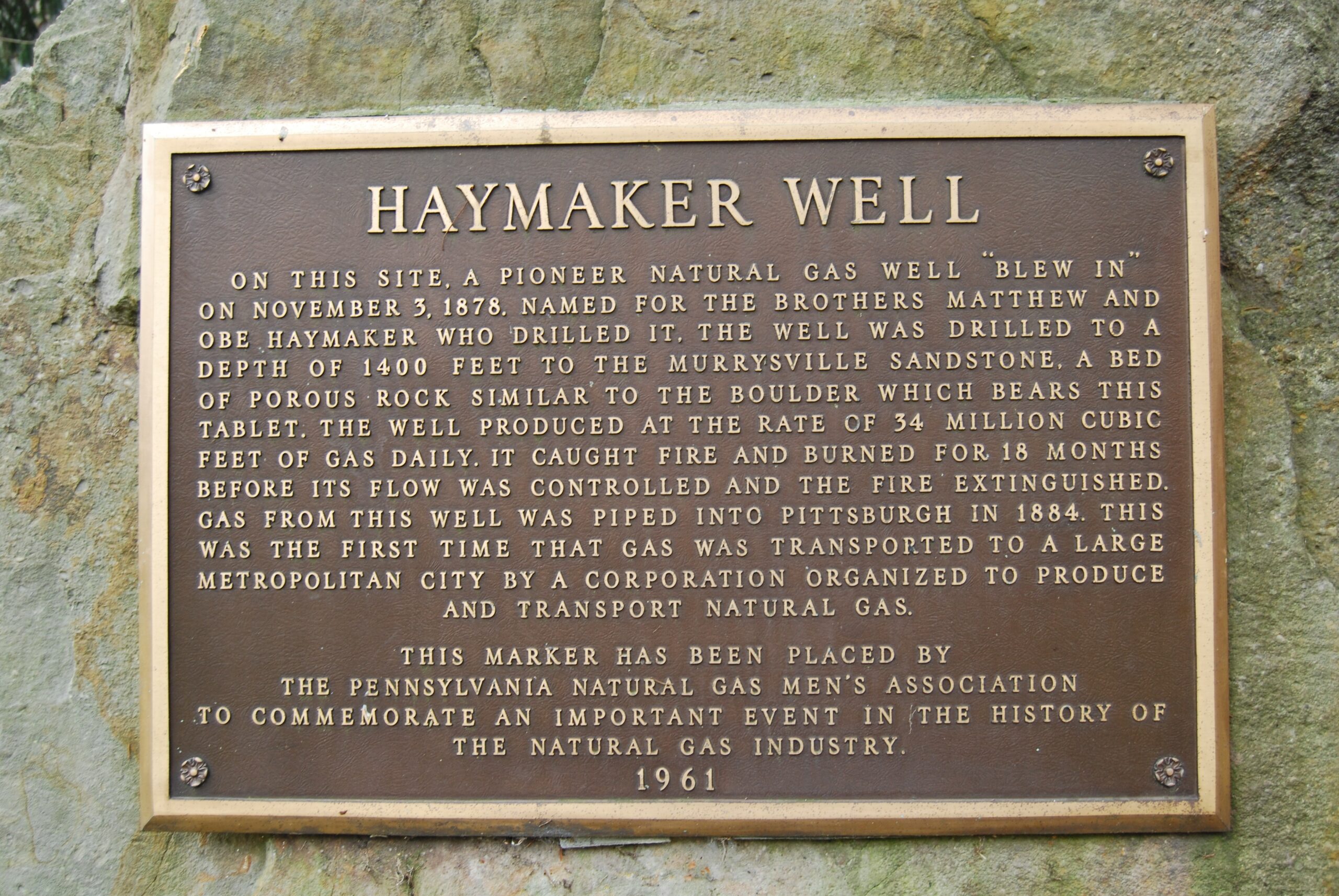
The transformation of Murrysville from a quiet agricultural outpost to the epicenter of a global industrial shift began with a geological accident. In 1878, the brothers Michael and Obadiah Haymaker, wildcatters chasing the same wealth that Colonel Drake had unearthed in Titusville two decades prior, secured a lease on the Remaley farm along Turtle Creek. Their objective was crude oil. They drilled through the "Big Injun" sand, exhausting their capital and their equipment. On November 3, 1878, at a depth of approximately 1, 400 feet, the drill bit breached the Murrysville Sandstone. The result was not a flow of oil, a violent expulsion of natural gas that blew the heavy wooden derrick into splinters. The brothers had tapped into a high-pressure reservoir capable of releasing an estimated 34 million cubic feet of gas per day. In 1878, this was not a fortune; it was a catastrophe.
For the residents of the Turtle Creek Valley, the Haymaker Well (Haymaker No. 1) became an immediate, deafening nightmare. Without the technology to cap such immense pressure, the gas roared uncontrolled. When a lantern spark ignited the plume in 1881, the well turned into a column of fire visible from downtown Pittsburgh, 18 miles away. The "roaring torch" burned for 18 months, turning night into day for the surrounding farms and slaughtering thousands of migrating birds attracted to the light. It became a macabre tourist attraction, drawing sightseers who watched the earth burn while the Haymaker brothers struggled to find a solution. The gas, a valuable commodity in the 21st century, was then viewed as a dangerous nuisance, a waste product that threatened to bankrupt the drillers.
The transition of this flaming geyser into a commercial asset required the intervention of outside capital and engineering risk. Joseph Newton Pew and Edward O. Emerson, partners who would later found the Sun Oil Company (Sunoco), recognized the thermal chance of the escaping vapor. They acquired an interest in the well, the route to monetization was paved with violence. On November 26, 1883, a dispute over ownership rights with a rival faction led by Chicago speculator Milton Weston erupted into a riot at the well site. In the ensuing melee, Obadiah Haymaker was bayoneted and shot; he died shortly after, becoming the martyr of the natural gas wars. The bloodshed marked the end of the amateur era and the beginning of corporate consolidation.
Pew and Emerson, operating as the Penn Fuel Company, succeeded where others failed. They engineered a method to cap the well and, more importantly, constructed a pipeline to transport the volatile fuel to the hungry furnaces of Pittsburgh. Completed in 1884, this pipeline infrastructure represented a massive leap in industrial logistics. For the time, a major metropolitan center received high-pressure natural gas for manufacturing and heating. The impact on Pittsburgh was immediate: the "Smoky City," choked by decades of bituminous coal soot, saw its skies clear temporarily as iron and glass works switched to the clean-burning fuel from Murrysville. The Haymaker strike had proven that natural gas was not a byproduct of oil drilling, a primary energy source capable of driving heavy industry.
The success of the Murrysville field attracted the attention of George Westinghouse, the prolific inventor and industrialist living in Pittsburgh's Point Breeze neighborhood. Westinghouse, observing the and danger of the early rush, entered the market with characteristic aggression. He drilled a well on the grounds of his own estate, "Solitude," tapping into the same geological formations. Realizing the need for safe distribution, Westinghouse invented new pressure-reduction valves and metering systems that made residential gas use practical. He formed the Philadelphia Company in 1884, rapidly acquiring leases in the Murrysville area and consolidating the chaotic web of competing pipelines into a regulated utility monopoly. His involvement ensured that the gas extracted from beneath Murrysville would power the Second Industrial Revolution in Western Pennsylvania.
Timeline of the Haymaker Gas Boom (1878, 1890)
Date
Event
Significance
Nov 3, 1878
Haymaker No. 1 Strikes Gas
Discovery of the Murrysville Gas Field; initially a blowout.
1881, 1882
The Great Fire
Well ignites and burns uncontrolled for 18 months.
Nov 26, 1883
Death of Obadiah Haymaker
Obadiah murdered during a riot over well ownership.
1884
Pipeline to Pittsburgh
Pew & Emerson complete the commercial city supply line.
1884
Westinghouse Enters Market
Formation of the Philadelphia Company to consolidate distribution.
1890
Sun Oil Company Formed
Pew and Emerson pivot profits from Murrysville to Ohio/Texas.
By the early 20th century, the immense pressure of the Murrysville field began to wane. The reckless venting of the early years had depleted the reservoir, and the industry's gaze shifted to new strikes in Ohio and the massive Spindletop discovery in Texas. Yet, the infrastructure laid down in Westmoreland County remained. The pipelines buried beneath the soil of Murrysville established rights-of-way that utility companies use to this day. The corporate entities born from this boom, Peoples Natural Gas and the antecedents of Sunoco, grew into multinational giants. In 2026, the physical site of the Haymaker Well is marked by a modest historical plaque and a replica derrick near the intersection of U. S. Route 22 and the William Penn Highway. While the roar of the escaping gas has long been silenced, the economic geology of the region remains a serious factor, with modern hydraulic fracturing operations in the Marcellus Shale revisiting the same subterranean depths that the Haymaker brothers punctured by accident nearly 150 years ago.
Transition from Franklin Township to Home Rule Charter (1976)
The mid-20th century brought a collision between the agrarian past of Franklin Township and the suburban reality of Western Pennsylvania. While the region legally remained a Second Class Township governed by a three-member Board of Supervisors, the post-war era had radically altered its demographics. The expansion of U. S. Route 22 and the Parkway East (I-376) turned the rolling farmland into a bedroom community for Pittsburgh and a hub for Westinghouse executives. By the 1970s, the population had surged, creating demands for services, police protection, zoning enforcement, and infrastructure planning, that the antiquated state township code could not adequately address. The rigid state laws designed for rural farming communities stifled the growing municipality, forcing it to operate within a "one-size-fits-all" statutory framework that ignored its specific suburban problems. The legal method to break these shackles arrived with Act 62 of 1972, known as the Home Rule Charter and Optional Plans Law. This legislation allowed Pennsylvania municipalities to draft their own "constitutions," transferring power from the state legislature to local voters. Franklin Township residents seized this opportunity. In the general election of November 1974, voters approved a referendum to elect a Government Study Commission. This body spent eighteen months examining the township's operations, holding public hearings, and debating the merits of various governance models. Their conclusion was blunt: the Second Class Township Code was obsolete. They recommended a Home Rule Charter that would replace the three supervisors with a Mayor-Council system and, symbolically, erase the name "Franklin Township" forever. The decisive moment came on April 27, 1976. In a primary election referendum, the electorate voted to adopt the Home Rule Charter. This vote was not administrative; it was an identity shift. The name "Franklin Township", shared by over twenty other municipalities in Pennsylvania, was discarded in favor of the "Municipality of Murrysville." This change aligned the legal government with the postal identity and the historic village founded by Jeremiah Murry. The charter established a separation of powers: a seven-member Council with legislative authority and an elected Mayor with executive and administrative powers, supported by a professional Chief Administrator. This structure was designed to professionalize operations and prevent the concentration of power that frequently plagued small township boards. The Charter took full legal effect on January 1, 1978, marking the official end of Franklin Township. Walt Dollman became the mayor of the newly minted Municipality of Murrysville. His administration immediately sought to define the municipality's place in the region, designating it the "Gateway to Westmoreland County" in 1977, a branding effort that acknowledged its strategic position on the border of Allegheny County. The transition was not without friction; the shift from a supervisor-roadmaster model to a professional manager-council system required a complete overhaul of ordinances, personnel policies, and financial planning. Yet, this restructuring allowed Murrysville to control its own zoning and taxation limits, powers that would prove important as development pressure intensified in the 1980s and 1990s. The adoption of Home Rule also fundamentally altered the relationship between the citizens and their government. Under the state code, residents had limited direct control over the structure of their local body. Under the Charter, the voters retained the right of initiative and referendum, allowing them to petition for changes to the law or the charter itself. This local autonomy insulated Murrysville from of the legislative gridlock in Harrisburg also placed the load of governance squarely on local officials. The 1976 vote remains the single most significant political event in the municipality's modern history, transforming a loose collection of farms and subdivisions into a unified, self-governing entity with the legal weight to manage its own destiny.
Topography, Watersheds, and Westmoreland Conservancy Reserves
Haymaker Gas Well and the 1878 Commercial Energy Boom
The physical reality of Murrysville is defined not by administrative lines by the relentless verticality of the Pittsburgh Low Plateau. This terrain, a dissected plateau ranging in elevation from approximately 755 feet where Turtle Creek exits the municipality to a summit of 1, 460 feet near the eastern border, dictates every aspect of development, drainage, and disaster management. The topography consists of narrow, winding valleys separated by broad, rolling ridges. This geological structure, formed by the of the ancient peneplain, creates a high-velocity drainage system where rainwater falling on the developed ridges accelerates rapidly into the sediment-choked valleys. The bedrock geology is primarily of the Monongahela and Conemaugh Groups, sedimentary from the Pennsylvanian period that contain the Pittsburgh Coal Seam. This seam, frequently six feet thick, has been extensively mined, leaving a subterranean legacy of subsidence risks that complicates modern construction and alters groundwater route.
The municipality's hydrological circulatory system is the Turtle Creek Watershed, a 147-square-mile basin that begins its westward journey here. Murrysville serves as the headwaters. The primary artery, Turtle Creek, does not flow alone; it is fed by a network of tributaries including Haymaker Run, Steels Run, and Lyons Run. These streams act as the primary storm drains for the region. Haymaker Run, paralleling the Murrysville Anticline, cuts through the heart of the commercial district, while Lyons Run drains the southern sector. Historically, these waterways were treated as industrial sewers, subjected to acid mine drainage (AMD) from the region's coal extraction. While remediation efforts in the late 20th and early 21st centuries improved water chemistry, the physical volume of water remains a lethal threat. The conversion of absorbent forests on the ridges into impervious pavement, parking lots, driveways, and roofs, has eliminated the land's ability to sponge rainfall, turning the valley floors into flash-flood zones.
The consequences of this topographical engineering failure were demonstrated with violent clarity on June 6, 2025. A stationary storm system dumped nearly 4 inches of rain on the municipality in a matter of hours, overwhelming the engineered culverts and natural channels alike. The resulting deluge was not high water; it was a hydraulic failure of the municipal infrastructure. Old William Penn Highway, the historic transit spine, was severed by floodwaters that necessitated boat rescues for trapped residents, an event that shattered the illusion of suburban safety. The Westmoreland Heritage Trail, a recreational jewel, suffered catastrophic washouts near Ginny's Neighborhood Pizza Joint, where the force of the water scoured away tons of limestone surface. This event, occurring less than a year prior to this report, exposed the inability of 20th-century stormwater planning to cope with the volatility of 2020s weather patterns. It was not an incident; similar, though less severe, flooding closed Route 22 in 2018 and 2019, establishing a pattern where the municipality's valleys are periodically reclaimed by their streams.
In opposition to the unchecked consumption of land for subdivision, the Westmoreland Conservancy emerged in 1991 as a strategic counter-force. The organization was not born from a vague desire for beautification from a specific tactical battle to stop the rezoning of the 56-acre Lillian Kellman property. Developers sought to convert this "S-1" conservation land into "R-2" residential density, a move that would have replaced a serious ecological buffer with a sea of half-acre lots. A group of residents mobilized, successfully blocked the zoning change, and facilitated the acquisition of the land, which became the municipality's nature reserve. This victory established the Conservancy's operational model: acquire specific, high-value parcels that protect watersheds and green corridors, holding them in public trust to prevent the suburban sprawl from fusing into a solid mass of concrete.
As of March 2026, the Westmoreland Conservancy holds title to or has protected over 600 acres of land, a fragmented archipelago of green amidst the development. The crown jewel of this network is the King Reserve. Originally acquired in 1996 from the King family, who had held the land since 1879, it was expanded by 26 acres in 2020 after a seven-year negotiation. encompassing 122 acres, the King Reserve protects the headwaters of Sylvan Run and Pearson's Creek, important tributaries that feed the larger Turtle Creek system. The reserve is a biological stronghold, containing the highest plant diversity of any Conservancy property, a direct result of its long undisturbed history. It serves as a serious sponge, absorbing millions of gallons of rainfall that would otherwise accelerate the flooding in the valleys.
The Morosini Reserve, spanning 183 acres, represents a different phase of the Conservancy's strategy: accessibility and connectivity. Acquired to prevent the fragmentation of a large forest block, Morosini features the Universal Pedestrian Trail (UPT). This project, unlike the rugged single-track of other reserves, was engineered to allow wheelchair and stroller access, democratizing the experience of the deep woods. Yet, even here, the tension between surface and subsurface rights is clear. While the Conservancy owns the trees and the soil, the mineral rights frequently belong to third parties. The region's position atop the Marcellus Shale means that conservation land exists in an uneasy truce with the energy industry. Well pads and pipelines crisscross the municipality, and while the reserves themselves are protected from surface drilling, the horizontal laterals of fracking operations extend beneath the very forests preserved for their silence and purity.
Other reserves play specific tactical roles in the watershed defense plan. The 43-acre Caywood Reserve on Hills Church Road protects a steep, wooded slope that drains directly into the flood-prone areas along the road. The McGinnis Reserve (52 acres) and the Walter Reserve (29 acres) act as green lungs in the central and western sectors. The Tomer Reserve (18 acres) and Flinn Reserve (20 acres) are smaller serious for maintaining connectivity for wildlife. The Conservancy's strategy has evolved from emergency interventions to long-term corridor planning. By 2026, the focus shifted toward linking these islands. The "Don Harrison Community Trail" project exemplifies this, stitching together Conservancy land, municipal parks, and private rights-of-way to create a continuous five-mile passage. This connectivity is essential not just for hikers, for the genetic health of wildlife populations that are otherwise genetically by the blocks of Route 22 and the Pennsylvania Turnpike.
The geological risks of Murrysville remain active. The Pittsburgh Coal Seam, mined out beneath large swaths of the municipality, presents a silent, lingering threat. Mine subsidence, the collapse of the rock strata into the voids left by coal removal, can occur decades after the miners have left. This geological instability, combined with the steep slopes of the Conemaugh Group strata, creates a where the ground itself is not always reliable. The interaction between this hollowed-out geology and the increasing intensity of rainfall events creates a complex risk profile. Water infiltrating into abandoned mines can pool, acidify, and eventually burst forth in new locations, or lubricate deep rock to trigger landslides. The 2018 landslides that affected local roads were a symptom of this hydro-geological friction.
The Westmoreland Conservancy's role has thus transitioned from simple land preservation to becoming a de facto infrastructure manager. By keeping steep slopes and headwaters forested, they provide a stormwater management service that the municipality could not afford to replicate with concrete and pipes. The 600 acres under their stewardship function as a massive, self-repairing utility, mitigating the worst effects of the topography. yet, the pressure remains intense. As the Pittsburgh metro area continues to push eastward, the value of developable land rises, increasing the cost of every future acre the Conservancy attempts to save. The 2025 floods served as a grim validation of their mission: every acre of forest saved is a few thousand gallons of water held back from the inundation of the valley floor.
Westmoreland Conservancy Reserves (Status 2026)
Reserve Name
Approx. Acreage
Primary Watershed Function
Key Features
Morosini Reserve
183
Headwater protection, sediment retention
Universal Pedestrian Trail, connectivity hub
King Reserve
122
Sylvan Run & Pearson's Creek protection
Highest biodiversity, historic King family land
Lillian Kellman
56
Runoff buffer for residential zones
acquisition (1991), Municipal Park
McGinnis Reserve
52
Steep slope stabilization
Mature hardwood forest, control
Caywood Reserve
43
Hills Church Road drainage buffer
Donated by Jane Caywood, steep terrain
Walter Reserve
29
Western sector absorption
Connects to Don Harrison Community Trail
Flinn Reserve
20
South Murrysville drainage
Nature study, no maintained trails
Tomer Reserve
18
Subdivision buffer
Donated by heirs of Barbara Holzshu Tomer
William Penn Highway Commercial Corridor and Traffic Infrastructure
The economic and physical spine of Murrysville is not a town square or a riverfront, a four-lane divided highway that slices the municipality in half. U. S. Route 22, known locally as the William Penn Highway, serves as the primary commercial artery and the source of the region's most persistent logistical friction. From the 18th-century packhorse trails to the artificial intelligence-driven traffic signals of 2026, the evolution of this corridor explains the municipality's transition from a rural outpost to a high-density suburban commercial zone. The road dictates the flow of capital, the speed of daily life, and the physical safety of the 20, 000 residents who must navigate its asphalt expanse.
The corridor's history predates the internal combustion engine by over a century. While the Forbes Road of 1758 cut a route through the wilderness nearby, the direct ancestor of the modern commercial strip was the Northern Turnpike. Chartered in 1807 and constructed between 1819 and 1821, this toll road connected Blairsville to Pittsburgh, running directly through what is Murrysville. It was an engineering feat of its time, replacing mud tracks with a stoned surface that allowed for reliable freight movement. The legacy of this era remains visible in the Northern Tollhouse on West Pike Street. Built originally as a cabin in 1784 and converted to a toll collection point in 1818, it stands as a testament to the long-standing monetization of travel in the sector. Early records indicate that tollkeepers like Nancy Clark charged travelers precise rates: six cents for a score of sheep, ten cents for cattle, and twelve cents per horse. This early infrastructure established the precedent that Murrysville would serve as a pass-through entity, a waystation between the industrial hub of Pittsburgh and the markets to the east.
The designation of the route as the William Penn Highway occurred in 1916, driven by the William Penn Highway Association to promote an auto trail parallel to the Pennsylvania Railroad. By 1926, the federal government codified the route as U. S. Route 22, integrating Murrysville into a national network stretching from Cincinnati to Newark, New Jersey. For the half of the 20th century, the road remained a two-lane undivided highway, lined with small motels, gas stations, and diners catering to the nascent auto-tourism industry. The Blue Spruce Motel, with its swimming pool and roadside cabins, exemplified this era. It was a time when the highway served the traveler rather than the commuter. Yet, the post-World War II suburban explosion fundamentally altered this. As Pittsburgh's population pushed eastward, the rural frontage along Route 22 became prime real estate for strip malls and car dealerships, creating a linear commercial district that absence a center.
By the 1990s, the volume of traffic had overwhelmed the existing infrastructure. The mix of high-speed through-traffic and local business access created a dangerous environment, frequently resulting in head-on collisions and fatalities. The stretch became known notoriously for its "death stretches," where the road narrowed or absence median blocks. In response, the Pennsylvania Department of Transportation (PennDOT) initiated a massive, multi-decade widening project. The reconstruction of Route 22 through Westmoreland County, a project spanning 18 years and costing hundreds of millions of dollars, aimed to expand the entire corridor to four lanes with concrete median blocks. The specific segment through Murrysville, from the "Cozy Inn cut-off" to Trafford Road, underwent intense reconstruction between 2003 and 2005. This project eliminated the suicide lanes did little to reduce the sheer volume of vehicles, which by the mid-2000s exceeded 40, 000 per day.
With the physical widening complete by 2011, the challenge shifted from capacity to flow management. The proliferation of traffic signals, required for every new shopping plaza, created a stop-and-go nightmare that strangled throughput. In 2014, PennDOT and the municipality deployed a technological solution: an adaptive traffic signal system developed by Rhythm Engineering. Marketed as "InSync," this system used cameras and software to adjust signal timing in real-time based on traffic demand, rather than fixed time-of-day schedules. For a brief period, the system reduced travel times and smoothed the morning commute. The $1. 8 million investment was hailed as a modernization victory.
The victory was short-lived. By the early 2020s, the Rhythm system began to degrade. Control boxes were damaged in accidents, and the proprietary technology became difficult to service. Drivers once again faced unsynchronized lights and inexplicable delays. By 2024, neighboring Monroeville had already abandoned the Rhythm system in favor of newer technology. In 2025 and 2026, Murrysville officials acknowledged the obsolescence of the decade-old system. The 2026 capital improvement plan allocated funds, supported by a $1. 4 million state grant, to replace the failing infrastructure with a Miovision system. This new pattern of upgrades highlights the municipality's perpetual struggle to keep pace with the demands of the highway. The technology changes, the fundamental problem of managing tens of thousands of vehicles through a retail corridor remains unsolved.
Commercial development along the highway has mirrored this infrastructure volatility. The transformation of the Blue Spruce Motel site into the Blue Spruce Shoppes in 2012 marked a shift toward "lifestyle centers" rather than traditional strip malls. The $15 million development brought upscale retail and dining to the corridor, attempting to create a destination rather than just a pit stop. Yet, the density of such developments continues to add friction to the roadway. Every new curb cut and turning lane invites chance conflict between high-speed transit and local commerce.
Table 5. 1: Major Infrastructure Milestones on the Murrysville Corridor (1800, 2026)
Period
Project / Event
Impact on Infrastructure
1819, 1821
Northern Turnpike Construction
stoned road surface; toll collection begins.
1926
U. S. Route 22 Designation
Integration into federal highway system; rise of auto-tourism.
2003, 2005
Murrysville Widening Project
Expansion to four lanes; installation of concrete medians.
2011
Regional Widening Completion
End of 18-year construction spanning Westmoreland County.
2014
Adaptive Signal Deployment
Installation of Rhythm Engineering "InSync" system.
2026
Signal System Replacement
Transition to Miovision technology due to hardware obsolescence.
As of 2026, the William Penn Highway remains the defining feature of Murrysville's built environment. It is a double-edged sword: it provides the tax base that funds the municipality's schools and services, yet it imposes a heavy cost noise, pollution, and safety risks. The crash data for the corridor continues to show a high incidence of rear-end collisions, a symptom of the stop-and-go nature of the signalized highway. The municipality's reliance on this single corridor for economic viability leaves it to shifts in commuting patterns and retail behavior. While the road has been widened, paved, and digitized over three centuries, it remains, at its core, a route for moving people and goods through the valley as quickly as physics and traffic lights allow.
2014 Franklin Regional High School Mass Stabbing Incident
Transition from Franklin Township to Home Rule Charter (1976)
On the morning of April 9, 2014, the Municipality of Murrysville became the site of a mass casualty event that drew national attention, not for the use of firearms, for the calculated application of primitive weaponry in a modern setting. At approximately 7: 13 AM, just minutes before the start of classes at Franklin Regional High School, 16-year-old sophomore Alex Hribal initiated an attack that would injure 21 students and one security guard. Armed with two eight-inch kitchen knives taken from his parents' home, Hribal moved through the -floor science hallway, slashing and stabbing victims in a manner witnesses described as emotionless and mechanical. The assault lasted approximately five minutes, a brief window of time that altered the trajectory of the school district and the community's perception of safety.
The mechanics of the attack reveal a disturbing level of planning contrasted with the chaos of execution. Hribal, dressed in black, moved through the crowded corridor as students congregated at their lockers. Unlike shooters who frequently fire from a distance, Hribal engaged his at close range, inflicting deep abdominal wounds. Medical reports from Forbes Regional Hospital later indicated a specific pattern to the injuries: the majority were directed at the lower right abdomen and flank, suggesting a methodical motion intended to cause maximum damage to important organs. One victim suffered a pierced liver, missing the heart and aorta by millimeters, while another required a ventilator due to a diaphragm puncture. The absence of fatalities was attributed not to the attacker's hesitation, to the rapid response of school staff and the proximity of Level II trauma centers.
The rampage ended only when Assistant Principal Sam King and student Ian Griffith physically subdued Hribal. King, who spotted the commotion, tackled the assailant, while Griffith helped restrain him until police arrived. During the struggle, Hribal reportedly refused to drop the weapons, stating, "My work is not done. I have more people to kill." This declaration later served as key evidence for prosecutors arguing against the defense's claims of a psychotic break disconnected from reality. The immediate aftermath saw the school transformed into a triage zone. Helicopters landed on the athletic fields to transport the most seriously wounded to UPMC Presbyterian and UPMC Mercy in Pittsburgh, while ambulances rushed others to Forbes Hospital in nearby Monroeville. In total, 22 individuals sustained stab wounds or slash injuries.
The legal proceedings that followed the April 9 incident focused heavily on the question of Hribal's mental state and whether he should be tried as an adult or a juvenile. The distinction carried immense weight: a juvenile disposition would have released him by age 21, whereas an adult conviction carried the chance for decades in prison. The defense team, led by attorney Patrick Thomassey, argued that Hribal suffered from severe depression and schizophrenia, asserting that bullying had driven him to a breaking point. yet, the prosecution, led by Westmoreland County District Attorney John Peck, presented a different narrative supported by a manifesto found in Hribal's locker. The document, dated days before the attack, expressed admiration for the perpetrators of the 1999 Columbine massacre and detailed Hribal's dissatisfaction with society. It contained no specific
Demographic Shifts and Household Income Metrics (1990, 2025)
By the early 1990s, Murrysville had largely completed its transformation from a rural outpost to a premier suburban stronghold, yet the decades that followed marked a distinct shift from rapid expansion to demographic maturation and wealth consolidation. While the population surged by 7. 5% between 1990 and 2000, climbing from 17, 240 to 18, 872, the explosive growth of the mid-20th century began to decelerate significantly as available land for large- development dwindled and the community's character solidified.
The most demographic alteration during this period was the rapid "graying" of the municipality. In 2000, the median age of a Murrysville resident was 43 years, a figure already higher than the national average, reflecting a community of established families rather than young starters. By 2024, this metric had climbed sharply to approximately 51. 2 years. This aging trend outpaced both Westmoreland County and the Commonwealth of Pennsylvania, signaling a transition from a town of school-aged children and parents to one increasingly dominated by empty-nesters and retirees. The data indicates that while the municipality remains attractive to families, the retention of older residents aging in place has fundamentally skewed the demographic profile.
Economically, Murrysville solidified its status as a bastion of affluence in Western Pennsylvania. The financial trajectory from 1990 to 2025 reveals a decoupling from regional rust-belt stagnation. In 2000, the median household income stood at $64, 071, a strong figure for the time. By 2023, this number had nearly doubled to approximately $121, 823, with projections for 2025 maintaining this upward trend. This income growth was not inflationary; it represented an influx of high-earning professionals, executives, and business owners drawn by the municipality's favorable tax structure and large-lot zoning. Poverty rates remained statistically negligible, hovering between 2% and 3% throughout the entire thirty-five-year window, a clear contrast to the economic distress visible in older industrial boroughs nearby.
The housing market mirrored this accumulation of wealth. As of early 2026, the median home value in Murrysville ranged between $330, 000 and $400, 000, depending on the index used, with new construction frequently exceeding $600, 000. The housing stock, primarily built between 1970 and 1999, consists largely of owner-occupied, single-family detached units. The owner-occupancy rate remained stubbornly high at approximately 92%, creating a high barrier to entry for lower-income residents and younger buyers. This structural exclusivity has insulated property values also contributed to the stagnation of total population numbers, which plateaued near 21, 000 residents by 2020 and showed signs of slight contraction in subsequent annual estimates.
Racial demographics in Murrysville have shifted at a glacial pace compared to national trends, yet visible changes occurred between 1990 and 2025. In 2000, the municipality was 95. 4% White, a figure of near-total homogeneity. Over the quarter-century, the Asian population emerged as the most significant minority group, growing to over 5% of the total populace by 2024. This demographic is frequently linked to the region's medical and educational sectors, specifically the proximity to Pittsburgh's university and healthcare hubs. The Black and Hispanic populations remained small, each constituting less than 2% of residents, reflecting the persistent regional segregation patterns of Greater Pittsburgh.
The Franklin Regional School District, the institutional heart of the community, faced the direct consequences of these shifts. While enrollment numbers remained relatively stable, hovering around 3, 400 to 3, 600 students in the early 2020s, the composition of households changed. The ratio of students to total households declined as the number of "empty nest" homes increased. Even with this demographic headwind, the district maintained its reputation for academic excellence, which served as the primary magnet for the younger families that did move into the area, replacing the graduating cohorts and preventing a steeper population drop.
By 2025, Murrysville presented a paradox of stability: a wealthy, safe, and highly educated community that was simultaneously shrinking in household size and aging rapidly. The "frontier" energy of the Jeremiah Murry era had long since dissipated, replaced by a preservationist ethos focused on maintaining property values, managing suburban sprawl, and servicing an older, more affluent citizenry. The challenge for the municipality in the coming years lies not in managing growth, in mitigating the slow, comfortable contraction of a mature suburb.
Unconventional Gas Drilling and Sanitary Landfill Environmental Impact
Topography, Watersheds, and Westmoreland Conservancy Reserves
The Municipality of Murrysville sits atop the Marcellus and Utica shale formations, a geological reality that has made it a recurring theater for the American energy industry's most aggressive extraction technologies. This history did not begin with modern hydraulic fracturing with the violent birth of the natural gas industry itself. In 1878, the Haymaker brothers, Michael and Obediah, drilled a well along Turtle Creek that would become the commercial natural gas well in the United States. The well, intended for oil, instead unleashed a uncontrollable torrent of gas that caught fire, burning as a roaring torch visible for miles for nearly two years. The chaotic early days culminated in 1883 when Obediah Haymaker was stabbed to death at the site during a dispute over ownership, a grim foreshadowing of the contentious battles over resource extraction that would define the region 140 years later.
By the early 21st century, the extraction methods had evolved from wooden derricks to multi-well pads employing high-volume hydraulic fracturing. The primary operator in Murrysville, Olympus Energy (formerly Huntley & Huntley), established the Titan well pad off Bollinger Road, a massive industrial installation in a community that had largely transitioned to a suburban residential identity. The tension between this residential character and industrial extraction reached a boiling point in December 2023, when the Murrysville Council voted 4-2 to lease the subsurface oil and gas rights of the municipality's two crown jewels, Duff Park and Murrysville Community Park, to Olympus Energy. The agreement, which promised over $2 million in upfront payments and 18% in royalties, allowed the operator to drill lateral bores thousands of feet beneath the parks from existing pads, including the Titan pad and the Poseidon pad in neighboring Penn Township.
The decision to monetize the parks ignited fierce opposition. Residents, organized under groups like the Murrysville Watch Committee and Protect PT (Penn-Trafford), argued that leasing public conservation land for fossil fuel extraction violated the spirit of the Environmental Rights Amendment of the Pennsylvania Constitution. In October 2024, a citizen petition demanding the rescission of these leases was formally rejected by the Council, cementing the municipality's financial dependence on the very industry that residents feared would degrade their air and water quality. The opposition was not ideological; Olympus Energy carried a record of environmental non-compliance, having accumulated hundreds of violations across its Pennsylvania operations, including a $175, 000 fine in 2021 for discharging sediment-laden water into a tributary of the Youghiogheny River in nearby Elizabeth Township.
Parallel to the drilling activities is the operation of the Valley Landfill, a massive waste disposal facility operated by Waste Management on the border of Murrysville and Penn Township. This site serves as a serious node in the region's fracking infrastructure, accepting "residual waste" which frequently includes drill cuttings, the solid rock and mud brought to the surface during the drilling process. These cuttings can contain naturally occurring radioactive materials (NORM), heavy metals, and high salinity levels. While the Valley Landfill captures methane for a 3-megawatt gas-to-energy plant, touted as a renewable energy source, the importation of fracking waste has raised persistent concerns about the long-term integrity of the site's leachate treatment systems and the chance for radioactive accumulation in the Turtle Creek watershed.
Major Environmental & Extraction Events in Murrysville (1878, 2026)
Year
Event
Details
1878
Haymaker Well Strike
commercial gas well in the U. S. strikes gas; burns uncontrolled for 18 months.
1883
Obediah Haymaker Murder
Co-founder of the well stabbed to death in ownership dispute.
2006
Valley Landfill Power Plant
Gas-to-energy facility comes online, converting landfill methane to electricity.
2019
Titan Well Pad Approved
Council approves Olympus Energy's Titan pad even with resident protests over setbacks.
2021
Olympus Energy Fine
PA DEP fines operator $175, 000 for sediment discharges in neighboring township.
2022
Ordinance Ruling
Commonwealth Court upholds Murrysville's fracking ordinance against citizen challenge.
2023
Park Lease Approval
Council votes 4-2 to lease subsurface rights of Duff Park and Community Park to Olympus.
2024
Petition Denial
Council rejects citizen petition to rescind park drilling leases in October.
The symbiotic relationship between the landfill and the gas industry creates a closed loop of environmental impact within the municipality. Gas wells produce waste that is trucked to the landfill; the landfill produces methane that is burned for power; and the municipality collects fees and royalties from both. This revenue stream, yet, comes with the "industrialization" of residential zones. The Titan well pad, for instance, required the construction of sound walls and the implementation of noise mitigation, yet residents continue to report low-frequency vibrations and light pollution. The approval of the park leases in 2023 marked a definitive shift, signaling that the municipality views its subsurface geology not as a protected heritage, as a liquid asset to be liquidated for budget stabilization.
Water quality remains the most insidious risk. The Turtle Creek watershed, which drains much of Murrysville, is already stressed by historical coal mine drainage. The addition of chance surface spills from drilling operations, combined with the discharge of treated landfill leachate, creates a complex chemical cocktail. While the Valley Landfill is distinct from the Westmoreland Sanitary Landfill in Rostraver, which faced severe sanctions for radioactive leachate in 2020, the regulatory classification of drill cuttings as "residual" rather than "hazardous" waste allows the Valley facility to accept tons of material that would be illegal to dispose of in other jurisdictions. As of 2026, the expansion of the landfill onto contiguous acreage remains a contentious prospect, with the "Flinn Reserve" area identified in county planning documents as a target for future waste capacity.
Franklin Regional School District Academic and Fiscal Performance
The Franklin Regional School District (FRSD) serves as the primary educational and fiscal entity binding the Municipality of Murrysville with the boroughs of Export and Delmont. Formed in 1961 through the consolidation of the Franklin Township School District and smaller borough systems, the district operates as a separate taxing authority with a 2025-2026 budget exceeding $71 million. While frequently for high academic metrics, the district faces intensifying fiscal pressures driven by pension obligations, capital debt service, and a reliance on local property taxes that forces annual millage increases. **Historical Formation and Consolidation (1834, 1961)** Education in the region prior to the 20th century relied on a decentralized network of one-room schoolhouses, authorized under the Pennsylvania Common Schools Act of 1834. By the early 1900s, Franklin Township operated small, localized facilities, while the industrial boroughs of Export and Delmont maintained independent systems to serve their denser populations. The post-World War II suburban boom necessitated a unified method. In 1961, the entities merged to form the Franklin Area School District, later renamed Franklin Regional. This consolidation centralized administration left a legacy of aging infrastructure spread across three distinct municipalities, a logistical reality that would dictate capital spending for the six decades. **Academic Performance Metrics (2020, 2026)** FRSD consistently ranks within the top tier of Pennsylvania public schools, yet this performance reveals a widening gap between district outcomes and state averages. Data from the 2024-2025 Future Ready PA Index demonstrates that Franklin Regional Senior High School students achieved a 66. 1% proficiency or advanced rate in Mathematics/Algebra, significantly outperforming the statewide average of 41. 7%. In English Language Arts, the district posted a 77. 9% proficiency rate against a state average of 49. 9%. Graduation rates remain a statistical stronghold, holding steady at approximately 95% to 98% through the 2020s, well above the state baseline of 88%. These metrics reinforce property valuations in Murrysville, as real estate marketing frequently centers on the district's "Blue Ribbon" caliber reputation. The district serves approximately 3, 350 students, a figure that stabilized in 2024 after a decade of slight decline from peak enrollment in the early 2000s. **Fiscal Structure and Tax load** The district's financial model relies heavily on local revenue, which accounts for approximately 69% of its funding, with the Commonwealth of Pennsylvania contributing roughly 27% and federal sources providing less than 4%. This structure places the duty of rising costs directly on Murrysville, Export, and Delmont property owners. The 2025-2026 fiscal year budget, approved in June 2025, totaled $71. 25 million and included a tax increase of 4 mills, bringing the total millage rate to 115. 86. This hike followed a 3. 5-mill increase in the 2024-2025 budget. District officials attribute these recurring increases to mandatory contributions to the Public School Employees' Retirement System (PSERS) and contractual salary obligations. In 2025, the district covered a $671, 000 deficit using unassigned fund balances, a tactic that fiscal watchdogs warn is unsustainable over long horizons. **The Sloan "Elementary Campus" Project (2016, 2021)** The most contentious fiscal event of the last decade involved the restructuring of the district's elementary education facilities. In 2016, a facilities study identified severe aging problem at Heritage Elementary and Newlonsburg Elementary. Rather than renovate all three sites, the School Board pursued a consolidation plan: the "Sloan Project." This $54 million capital initiative involved renovating Sloan Elementary and constructing a new intermediate school on the same campus to house grades 3-5. The plan necessitated the closure and demolition of Heritage Elementary and the repurposing of Newlonsburg Elementary into an administrative center. The project faced sharp community opposition regarding traffic congestion on Sardis Road and the sheer magnitude of the debt incurred. Even with the "Restore Taxpayer Trust" slate of candidates challenging the project in the 2019 election, the board proceeded. The consolidated campus opened for the 2021-2022 school year, fundamentally altering the district's physical footprint and locking the tax base into long-term debt service payments. **Security and the Legacy of April 9, 2014** The district's method to safety changed permanently on April 9, 2014, when a 16-year-old sophomore, Alex Hribal, used two kitchen knives to stab and slash 20 students and a security guard in the high school hallways. Although no victims died, the attack exposed vulnerabilities in suburban school security. In the immediate aftermath, the district allocated funds to harden infrastructure, including a $280, 000 expenditure for secure doors and vestibules. By 2024, security had evolved into a detailed system involving armed school police officers, advanced surveillance, and mandatory threat assessment teams. The fiscal impact of these measures is a permanent line item in the annual operating budget, representing a shift from passive safety to active, personnel-heavy security strategies. **Current Fiscal Outlook (2026)** As of early 2026, FRSD faces a convergence of economic pressures. The debt service from the Sloan project remains a fixed cost, while inflation has driven up the price of healthcare benefits and utilities. The district's borrowing capacity is, and the reliance on fund balance transfers to close budget gaps suggests that tax levies continue to rise. The administration occupies the repurposed Newlonsburg building, a symbol of the district's contraction and consolidation, while the razed site of Heritage Elementary stands as a testament to the aggressive modernization efforts that defined the previous decade.
FRSD Fiscal and Academic Snapshot (2024-2026)
Metric
Data Point
Context
2025-2026 Budget
$71. 25 Million
Includes $671k deficit coverage
Millage Rate (2025-26)
115. 86 Mills
Increased by 4. 0 mills from prior year
Math Proficiency
66. 1%
State Avg: 41. 7% (Future Ready PA)
ELA Proficiency
77. 9%
State Avg: 49. 9% (Future Ready PA)
Local Funding Share
~69%
High reliance on property taxes
Sloan Project Cost
~$54 Million
Major debt driver; completed ~2021
Municipal Council Governance and Voting Registration Trends
William Penn Highway Commercial Corridor and Traffic Infrastructure
The governance of Murrysville represents a distinct evolution from the frontier lawlessness of the 18th century to a highly structured, corporate-style municipal management system in the 21st. While the region began as a loose collection of land grants patrolled by militia and later operated under the standard Second Class Township Code of Pennsylvania, the modern political apparatus rests entirely on the Home Rule Charter adopted by referendum on April 27, 1976. This document, which became on January 1, 1978, fundamentally altered the power of the community. It stripped the electorate of the ability to directly manage administrative minutiae, transferring operational authority to a professional Chief Administrator while retaining legislative power within a seven-member Council. This shift marked the transition of Murrysville from a rural farming community to a suburban political entity capable of negotiating complex contracts with multinational energy corporations.
Under this Home Rule structure, the Municipality operates a "Council-Manager" form of government, a system designed to insulate daily operations from political volatility. The Council, elected at-large to four-year overlapping terms, appoints the Chief Administrator, who functions as the CEO of the municipality. As of 2026, this role is held by Michael Nestico, who succeeded long-time administrator Jim Morrison in June 2022. The Administrator holds significant sway, drafting the budget, managing the police and public works departments, and serving as the primary negotiator for development projects. The Mayor, conversely, occupies a "weak mayor" position defined by the Charter. The Mayor presides over ceremonial functions and holds veto power over ordinances, a power rarely exercised and easily overridden by a council majority, absence a vote on the council except to break ties. The Mayor's only direct operational authority lies in the supervision of the Police Department, a check designed to keep law enforcement separate from the legislative body.
Voter registration trends in Murrysville reveal a hardening of partisan lines that mirrors the broader political shift of Westmoreland County. Throughout the mid-20th century, the municipality maintained a competitive balance between Democrats and Republicans, driven by a mix of union-aligned labor households and white-collar professionals. By the 2020s, this balance had evaporated. Murrysville stands as a of Republican power. Registration data from 2024 and 2025 shows a decisive GOP advantage, with the municipality serving as a wealthy, high-turnout anchor for conservative candidates countywide. The median age of the voting population, hovering near 48, combined with a median household income method $80, 000, creates a demographic profile that favors fiscal conservatism and pro-development policies. In local elections, Democratic candidates frequently struggle to clear the 40% threshold, frequently running as token opposition against well-funded Republican slates.
The November 2025 municipal election crystallized this one-party dominance. The race for four Council seats resulted in a sweep for the Republican ticket. Incumbents Jason Lemak and Jamie Lingg secured re-election, joined by newcomers Darren Miller and Michael Korns. Miller, a fresh face in local politics, led the field with approximately 23% of the vote, signaling a voter appetite for continued conservative management. The most significant shift in 2025 occurred in the Mayoral office. Dayne Dice, previously the Council President and a central figure in recent legislative controversies, ran unopposed for Mayor, receiving over 98% of the vote. His transition from the legislative head to the executive branch in January 2026 solidified the continuity of the governing faction, ensuring that the pro-development agenda established during his council presidency would face no executive resistance.
The defining governance test of the 2020-2026 period was not an election, a legislative transaction: the leasing of subsurface rights under municipal parks for hydraulic fracturing. In December 2023, the Council voted 4-2 to approve leases with Olympus Energy, allowing the corporation to extract natural gas from beneath Duff Park and Murrysville Community Park. This decision generated $2 million in upfront revenue and secured 18% royalties for the municipality, yet it ignited fierce opposition from residents concerned about the industrialization of protected green spaces. The vote split the council, with then-President Dayne Dice and Councilman Jason Lemak voting in favor, while Councilman Carl Stepanovich opposed the measure. This vote demonstrated the Council's willingness to use public assets for revenue, a philosophy that prioritizes fiscal solvency over preservationist objections. The absence of electoral consequences for the "Yes" voters in the subsequent 2025 election confirms that the silent majority of Murrysville's electorate either supports or remains indifferent to unconventional gas drilling, provided it subsidizes the tax base.
The table details the Municipal Council composition and key officers during the serious transition period of 2024, 2026, highlighting the continuity of leadership even with the shift of Dayne Dice from Council President to Mayor.
Official
Role (2024-2025)
Role (2026)
Party Affiliation
Key Votes / Notes
Dayne Dice
Council President
Mayor
Republican
Voted YES on 2023 Park Fracking Lease; Ran unopposed for Mayor 2025.
Regis Synan
Mayor
Retired/Term Ended
Republican
Served as Mayor through the fracking debates; limited voting power.
Michael Nestico
Chief Administrator
Chief Administrator
Appointed
Operational CEO; negotiated Olympus Energy contracts.
Jason Lemak
Council Member
Council Member
Republican
Re-elected Nov 2025; Voted YES on Fracking Lease.
Jamie Lingg
Council Member
Council Member
Republican
Re-elected Nov 2025; Voted YES on Fracking Lease.
Darren Miller
Candidate
Council Member
Republican
Top vote-getter Nov 2025; Newcomer to Council.
Michael Korns
Candidate
Council Member
Republican
Elected Nov 2025; Newcomer.
Carl Stepanovich
Council Member
Council Member
Republican
Voted NO on 2023 Fracking Lease; Term extends through 2026.
Mac McKenna
Council Member
Council Member
Republican
Voted YES on 2023 Fracking Lease.
Beyond the Council chamber, the governance of Murrysville relies heavily on appointed boards and commissions, which serve as gatekeepers for development. The Planning Commission and the Zoning Hearing Board operate as the technical filters for the Home Rule Charter's mandates. In 2019, the Zoning Hearing Board played a pivotal role in the "Titan" well pad controversy, ruling against citizen challenges to the fracking ordinance. These boards are staffed by volunteers appointed by the Council, ensuring that the ideological composition of the regulatory bodies mirrors the elected leadership. The alignment between the Council, the Planning Commission, and the Zoning Board creates a streamlined route for development applications, reducing the friction that developers face in more fractured municipalities.
The financial governance of the municipality is equally centralized. The Chief Administrator presents the budget, the Council holds the power of the purse. The decision to use fracking royalties to fund capital improvements, such as park upgrades and equipment purchases, rather than raising the Earned Income Tax or property millage has become a of Murrysville's fiscal strategy. This reliance on extractive industry revenue insulates residents from direct tax increases, a political need in a conservative jurisdiction. The 2025 budget process, overseen by Nestico and approved by the Dice-led Council, reinforced this model, projecting stable tax rates even with inflationary pressures, largely due to the influx of gas lease funds.
As Murrysville moves through 2026, the governance structure faces the long-term challenge of managing a mature suburb. The era of rapid residential expansion has slowed, replaced by the need to maintain aging infrastructure and manage the industrial footprint of the energy sector. The consolidation of power in the hands of a unified Republican Council and a strong Chief Administrator suggests that the municipality continue to prioritize business-friendly policies and fiscal conservatism. The dissent voiced during the 2023 fracking hearings remains a minority position, unable to breach the electoral firewall of the Home Rule system. The transition of Dayne Dice to the Mayor's office symbolizes this stability: the faces may change positions, the philosophy of governance remains absolute.
Corporate Parks and Regional Medical Facility Expansion
The transformation of Murrysville from a pastoral agricultural community into a commercial powerhouse along the Route 22 corridor represents a calculated, frequently contentious, evolution of land use that accelerated sharply between 1990 and 2026. While the municipality's early history was defined by the Remaley, Hoey, and Haymaker families tilling the soil and tapping the gas wells, the modern era is defined by the zoning map and the aggressive courtship of tax-generating corporate tenants. This shift was not organic; it was engineered by municipal planners and county officials seeking to offset the residential tax load with commercial revenue, a strategy that yielded significant economic engines also introduced volatility tied to global corporate fortunes.
The William Penn Highway (Route 22) serves as the central artery for this development, evolving from a dirt wagon trail in the early 1800s to a four-lane commercial spine by the mid-20th century. yet, the true industrialization of Murrysville did not occur along the highway's retail frontage, rather in the dedicated zones carved out of the northern woodlands. The Westmoreland Business and Research Park, established in the early 1990s, stands as the primary example of this initiative. Spanning over 400 acres and straddling the border with Upper Burrell and Washington Township, this park was designed to attract light manufacturing and technology firms that required large footprints unavailable in the steep topography closer to Pittsburgh.
For nearly three decades, the Westmoreland Business and Research Park functioned as the municipality's economic iron lung. Its success was heavily anchored by Philips Respironics, a medical device giant that established a massive presence in the park. In 2009, Philips expanded its footprint with a 172, 000-square-foot facility dedicated to the production of sleep and respiratory products. This facility, along with an older plant opened in 1990, made Philips one of the largest employers in the region, providing high-wage manufacturing jobs that anchored the local housing market. The symbiotic relationship between the municipality and the corporation appeared stable until the 2020s, when a product safety emergency exposed the fragility of relying on a single dominant corporate tenant.
In 2021, Philips Respironics initiated a global recall of millions of CPAP and BiPAP machines due to the degradation of sound-abatement foam, which posed serious health risks to users. The was catastrophic for the local division. By 2024, the company entered into a consent decree with the U. S. Department of Justice and the FDA, halting the sale of new sleep apnea devices in the United States. The economic shockwave hit Murrysville immediately. In June 2024, Philips announced the elimination of 300 manufacturing jobs in Western Pennsylvania, signaling a contraction of the very industrial base that municipal leaders had cultivated for thirty years. While the company moved headquarters staff to the Murrysville and New Kensington sites, the reduction in manufacturing capacity raised urgent questions about the long-term viability of the large- industrial park model in a post-industrial economy.
Parallel to the industrial shifts in the north, the Route 22 corridor witnessed a different kind of struggle: the stagnation of the "pure" office park and the rise of the "med-tail" (medical retail) hybrid. The Murrysville Corporate Park, located off Old William Penn Highway, faced a more difficult trajectory than its northern counterpart. Designed to attract white-collar corporate headquarters, it frequently struggled with vacancy rates that the optimistic projections of the early 2000s. By 2024, the post-pandemic reality of remote work had rendered the traditional suburban office campus partially obsolete. This forced the Municipality to reconsider its zoning strictures, leading to the 2024-2025 updates to the "Business Overlay District." These changes were an admission that commercial zones could no longer survive as office-only monocultures; they needed to integrate residential and retail elements to remain solvent.
The most visible manifestation of this new mixed-use philosophy is the Blue Spruce Shoppes. Developed by Legacy Realty Partners and approved in 2012 after contentious debates regarding traffic and environmental impact, Blue Spruce represented a departure from the strip-mall vernacular of Route 22. Instead of big-box retail, it curated a mix of high-end dining, boutique retail, and, crucially, medical offices. This development model anticipated the aggressive expansion of regional healthcare systems into suburban markets, a trend that intensified between 2015 and 2026.
Comparative Analysis: Major Commercial Zones in Murrysville (2025 Status)
Zone Name
Primary Focus
Key Anchor Tenant(s)
Economic Status (2025-2026)
Westmoreland Business & Research Park
Light Industrial / Manufacturing
Philips Respironics
Destabilized by 2024 layoffs; shifting toward logistics/warehousing.
Murrysville Corporate Park
Professional Office
Various Small Firms
Stagnant; undergoing zoning shifts to allow mixed-use.
Blue Spruce Shoppes
Retail / Medical / Dining
Blue Spruce Health / UPMC / AHN
High occupancy; model for future "Med-tail" development.
Wilson Road Corridor
Mixed-Use / Corporate
Dedicated Nursing Associates
Active construction; hybrid of residential (Regan Ridge) and corporate HQ.
The medical facility expansion in Murrysville is not a service upgrade; it is a territorial conflict between the region's two healthcare duopolies: UPMC (University of Pittsburgh Medical Center) and AHN (Allegheny Health Network). Throughout the 2010s and 2020s, these entities engaged in a "white coat war," racing to capture the insured patient base of Westmoreland County. While UPMC East in Monroeville and AHN Forbes Hospital serve as the acute care hubs, Murrysville became the battleground for outpatient dominance. By 2026, the Route 22 corridor was dotted with urgent care centers, imaging labs, and primary care offices, turning the highway into a linear medical district. This proliferation provided residents with convenient access to care also drove up commercial rents and increased traffic congestion on an already thoroughfare.
A specific case study of this corporate-medical integration is the Dedicated Nursing Associates (DNA) project near Wilson Road. Originally conceived as a corporate campus, the project faced delays and scope changes, eventually evolving into a mixed-use development that included the "Regan Ridge" luxury villas. This pivot illustrates the necessary compromise of modern suburban development: corporate tenants like DNA provide the jobs, the financial viability of the land development requires high-density residential units to subsidize the infrastructure costs. The friction between existing residents, who fear increased traffic and the loss of rural character, and the municipality's need for tax revenue came to a head during the approval processes for these hybrid developments in 2024 and 2025.
The economic data from 2020 to 2026 shows a clear. Traditional retail tax revenue flattened as e-commerce eroded brick-and-mortar sales, while the "Service" and "Medical" sectors saw revenue growth. yet, the reliance on the Earned Income Tax (EIT) makes the municipality to corporate downsizing. The Philips Respironics layoffs in 2024 served as a clear warning: when a major employer sneezes, the municipal budget catches a cold. Consequently, the strategy for 2026 and beyond has shifted toward diversification. The Planning Commission's focus on the Business Overlay District aims to prevent future "ghost parks" by allowing adaptive reuse of office buildings into residential units or light logistics hubs, acknowledging that the era of the single-tenant corporate is ending.
Infrastructure limitations remain the primary governor on this growth. The topography of Murrysville, defined by steep ridges and narrow valleys, limits the expansion of sewage and water lines necessary for dense corporate parks. The Westmoreland County Industrial Development Corporation (WCIDC) exhausted the easily developable land in the Business and Research Park by 2015, leaving only difficult, expensive parcels. This physical reality forces new development back toward the Route 22 corridor, increasing density and conflict with residential zones. The "corporate park" of the future in Murrysville is likely not a park at all, a vertical, mixed-use structure along the highway, integrating the clinic, the office, and the apartment into a single, tax- footprint.
2020, 2026 Zoning Disputes and Suburban Density Management
By 2020, the Municipality of Murrysville had entered a period defined by the collision of its rural heritage with modern industrial and suburban demands. The primary method for this conflict was the "overlay district," a zoning tool that allowed heavy industrial uses, specifically unconventional natural gas drilling (fracking), within areas previously as Rural Residential. While the municipality sought to balance tax revenue with preservation, the years 2020 through 2026 saw repeated legal and civic confrontations over land use, establishing a pattern where residential expansion and resource extraction competed for the same finite acreage.
The legal framework for this era was solidified in January 2022, when the Commonwealth Court of Pennsylvania ruled in Murrysville Watch Committee v. Municipality of Murrysville Zoning Hearing Board. The court affirmed the municipality's ordinance, which permitted oil and gas wells as a conditional use in specific overlay districts. The ruling ended a long-standing challenge by residents who argued that industrial drilling was incompatible with residential zoning. This legal victory for the municipality and industry paved the way for Olympus Energy (formerly Huntley & Huntley) to expand operations. The Titan well pad, located off Bollinger Road, became a focal point of this expansion. even with strict conditions imposed by the Council, including noise monitoring and a three-year drilling window, the site represented the industrialization of the municipality's interior, placing heavy truck traffic on narrow, winding roads like Hilty and Bollinger.
Tensions escalated significantly in December 2023, when the Murrysville Council voted 4-2 to lease the subsurface oil and gas rights of Duff Park and Murrysville Community Park to Olympus Energy. Duff Park, a Wild Plant Sanctuary, held symbolic importance to residents. Although the lease prohibited surface disturbance within the parks, necessitating that drilling occur from adjacent private pads, the decision sparked outrage. Environmental advocacy group Protect PT organized petitions to rescind the leases, arguing that the municipality had prioritized a $2 million upfront payment and future royalties over the integrity of public conservation lands. In October 2024, the Council unanimously denied a citizen petition to cancel these agreements, citing binding contractual obligations and the risk of litigation from the energy company.
Parallel to the extraction disputes, residential development faced its own emergency of density and execution. The post-2020 housing market drove demand for "patio homes" and low-maintenance communities favored by an aging demographic, clashing with the existing single-family sprawl. A prime example of this friction was the Regan Ridge development near Manor and Wilson roads. Originally approved as "luxury villas," the project stalled by 2025, leaving partially built structures and frustrated neighbors. In October 2025, the developer attempted to rezone a portion of the land for a commercial gym to accelerate cash flow. The Council rejected this request, enforcing the original residential zoning to prevent commercial creep into the neighborhood. Similarly, in May 2024, residents of the Summer Hill district successfully pressured the Planning Commission to scrutinize a Ryan Homes proposal for 61 new townhomes, citing dangerous traffic bottlenecks on the subdivision's single access road.
The infrastructure resulting from these dual pressures, industrial traffic and residential density, dominated the 2025 municipal elections. Candidates universally identified the update of the detailed Plan (originally enacted in 2015) as the most urgent task for the incoming administration. The 2026, 2030 Capital Improvement Plan, presented in August 2025, reflected this reality by shifting focus from expansion to maintenance. The plan allocated $23. 7 million primarily for the rehabilitation of deteriorating roads and, acknowledging that the tax base growth from new developments had not kept pace with the degradation of existing infrastructure.
Key Land Use Disputes in Murrysville (2020, 2026)
Project / Dispute
Year
Core Conflict
Outcome
Titan Well Pad
2020, 2022
Industrial extraction in residential zone; noise and traffic concerns.
Approved with conditions; Ordinance upheld by Commonwealth Court.
Duff Park Lease
2023, 2024
Leasing subsurface rights of a nature reserve for fracking revenue.
Council approved lease 4-2; petition to rescind denied in 2024.
Summer Hill Expansion
2024
High-density townhomes vs. single-access road capacity.
Residents forced plan revisions and scrutiny over traffic safety.
By early 2026, Murrysville stood at a definitive crossroads. The "rural residential" identity that had attracted thousands since the 1970s was legally and physically overlaid with a grid of industrial extraction and suburban density. The failure of the Regan Ridge project served as a warning against speculative overdevelopment, while the Duff Park lease demonstrated the municipality's willingness to monetize natural resources to fund its operations. As the detailed Plan update began, the primary challenge was no longer managing growth, managing the permanent friction between the quiet bedroom community residents believed they bought into and the resource-rich, traffic-heavy reality that had actually developed.
Why it matters: The Southeast Asian digital economy has shifted from an open field to a rigid duopoly controlled by Grab and GoTo, impacting ride-hailing and food delivery…
What do we know about Colonial Origins and the Jeremiah Murry Land Grants?
The origins of Murrysville are not found in a peaceful agrarian expansion in the violent, fractured aftermath of the American Revolution on the Pennsylvania frontier. In 1781, the region defined as the Municipality of Murrysville was a dangerous borderland within Westmoreland County.
What do we know about Haymaker Gas Well and the Commercial Energy Boom?
The transformation of Murrysville from a quiet agricultural outpost to the epicenter of a global industrial shift began with a geological accident. In 1878, the brothers Michael and Obadiah Haymaker, wildcatters chasing the same wealth that Colonel Drake had unearthed in Titusville two decades prior, secured a lease on the Remaley farm along Turtle Creek.
What do we know about Transition from Franklin Township to Home Rule Charter?
The mid-20th century brought a collision between the agrarian past of Franklin Township and the suburban reality of Western Pennsylvania. While the region legally remained a Second Class Township governed by a three-member Board of Supervisors, the post-war era had radically altered its demographics.
What do we know about Topography, Watersheds, and Westmoreland Conservancy Reserves?
The physical reality of Murrysville is defined not by administrative lines by the relentless verticality of the Pittsburgh Low Plateau. This terrain, a dissected plateau ranging in elevation from approximately 755 feet where Turtle Creek exits the municipality to a summit of 1, 460 feet near the eastern border, dictates every aspect of development, drainage, and disaster management.
What do we know about William Penn Highway Commercial Corridor and Traffic Infrastructure?
The economic and physical spine of Murrysville is not a town square or a riverfront, a four-lane divided highway that slices the municipality in half. U.
What do we know about Franklin Regional High School Mass Stabbing Incident?
On the morning of April 9, 2014, the Municipality of Murrysville became the site of a mass casualty event that drew national attention, not for the use of firearms, for the calculated application of primitive weaponry in a modern setting. At approximately 7: 13 AM, just minutes before the start of classes at Franklin Regional High School, 16-year-old sophomore Alex Hribal initiated an attack that would injure 21 students and one security guard.
What do we know about Demographic Shifts and Household Income Metrics?
By the early 1990s, Murrysville had largely completed its transformation from a rural outpost to a premier suburban stronghold, yet the decades that followed marked a distinct shift from rapid expansion to demographic maturation and wealth consolidation. While the population surged by 7.
What do we know about Unconventional Gas Drilling and Sanitary Landfill Environmental Impact?
The Municipality of Murrysville sits atop the Marcellus and Utica shale formations, a geological reality that has made it a recurring theater for the American energy industry's most aggressive extraction technologies. This history did not begin with modern hydraulic fracturing with the violent birth of the natural gas industry itself.
What do we know about Franklin Regional School District Academic and Fiscal Performance?
The Franklin Regional School District (FRSD) serves as the primary educational and fiscal entity binding the Municipality of Murrysville with the boroughs of Export and Delmont. Formed in 1961 through the consolidation of the Franklin Township School District and smaller borough systems, the district operates as a separate taxing authority with a 2025-2026 budget exceeding $71 million.
What do we know about Municipal Council Governance and Voting Registration Trends?
The governance of Murrysville represents a distinct evolution from the frontier lawlessness of the 18th century to a highly structured, corporate-style municipal management system in the 21st. While the region began as a loose collection of land grants patrolled by militia and later operated under the standard Second Class Township Code of Pennsylvania, the modern political apparatus rests entirely on the Home Rule Charter adopted by referendum on April 27, 1976.
What do we know about Corporate Parks and Regional Medical Facility Expansion?
The transformation of Murrysville from a pastoral agricultural community into a commercial powerhouse along the Route 22 corridor represents a calculated, frequently contentious, evolution of land use that accelerated sharply between 1990 and 2026. While the municipality's early history was defined by the Remaley, Hoey, and Haymaker families tilling the soil and tapping the gas wells, the modern era is defined by the zoning map and the aggressive courtship of tax-generating corporate tenants.
What do we know about Zoning Disputes and Suburban Density Management?
By 2020, the Municipality of Murrysville had entered a period defined by the collision of its rural heritage with modern industrial and suburban demands. The primary method for this conflict was the "overlay district," a zoning tool that allowed heavy industrial uses, specifically unconventional natural gas drilling (fracking), within areas previously as Rural Residential.
Why it matters: The Judicial Appointment Lobbying Industry has transformed the acquisition of the American judiciary into a capitalized industry, with significant financial implications. Financial escalation in judicial…
Why it matters: The World Economic Forum (WEF) has shifted its focus from "efficiency" to "resilience" in response to global challenges like the COVID-19 pandemic and the war…
Why it matters: Desalination is a critical solution to the global water crisis, offering a stable supply of potable water as freshwater resources dwindle. Technological advancements have made…
Why it matters: Financial burden of wildfire management shifting from utilities to consumers Escalating costs due to climate change, development in fire-prone areas, and aging infrastructure In recent…
Why it matters: President Trump signed a federal budget bill with significant implications for wealth distribution in the U.S., including tax breaks for the wealthy and cuts to…
Why it matters: India's booming cities are facing a troubling trend of urban slum fire evictions, raising concerns about intentional destruction for land grabs and redevelopment projects. An…
Get updates on this place
Get verified alerts when this file is updated (verification required).