Verified Against Public And Audited RecordsLast Updated On: 2026-03-05
Reading time: ~52 min
File ID: EHGN-PLACE-35524
Investigative Bio of Oia
Venetian Fortifications and the Castle of Agios Nikolaos (1480, 1800)
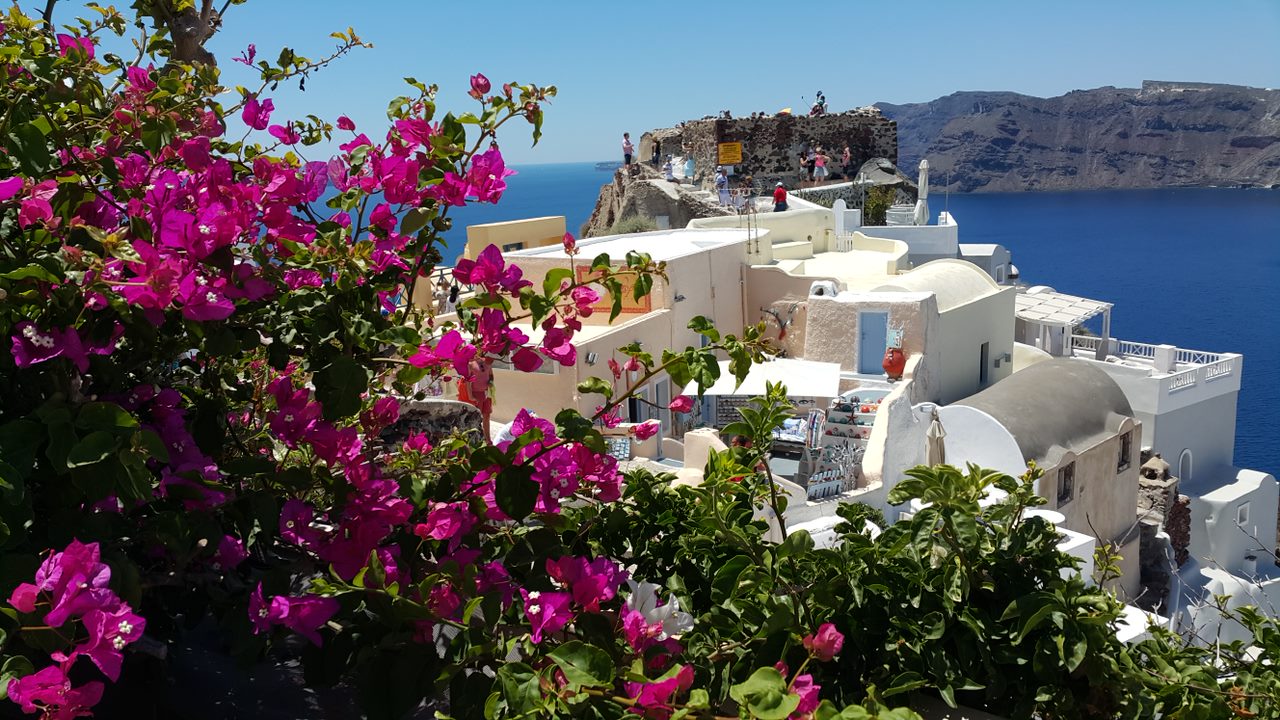
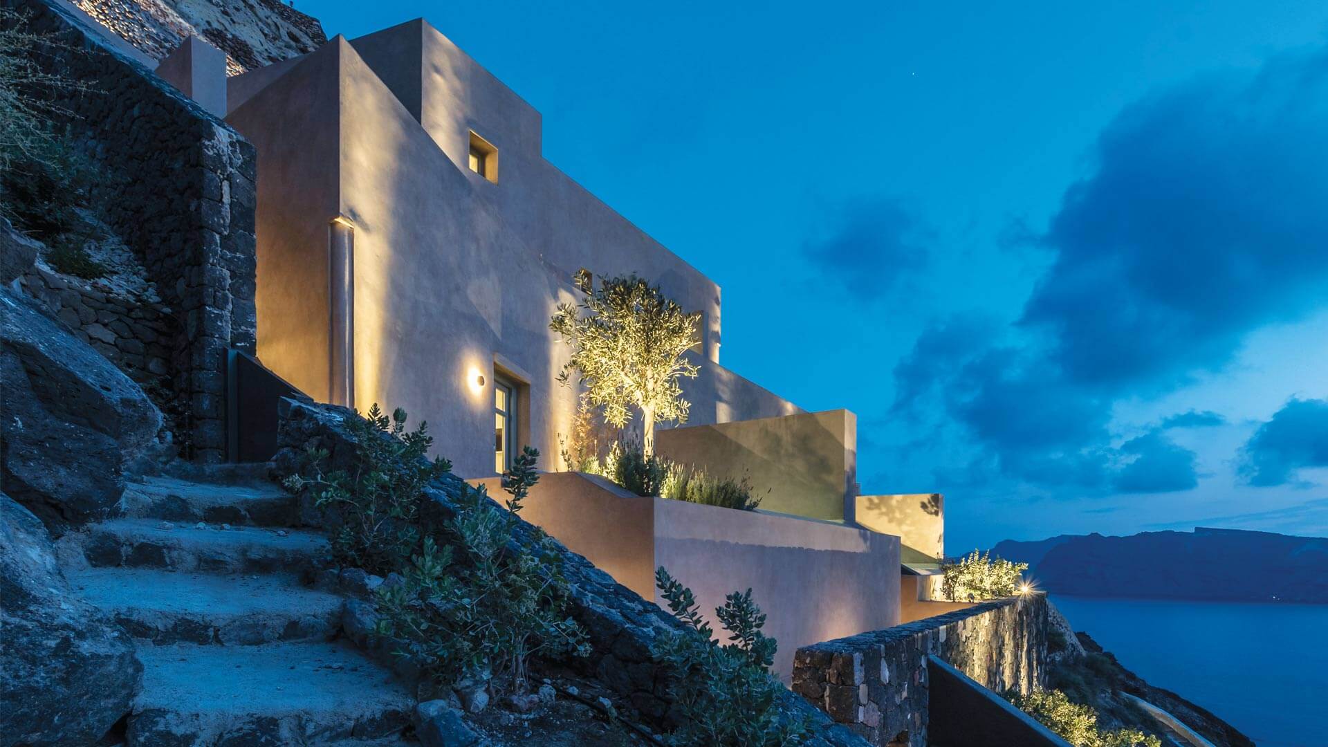
The Castle of Agios Nikolaos, perched on the northwestern tip of Santorini, functions not as a ruin as a barometer for the island's geopolitical and geological volatility. Originally constructed around 1480 by the Venetian Dargent family, the fortification was one of the five "Kastelia" designed to protect the island's inhabitants from pirate raids. By the dawn of the 18th century, the castle had evolved from a purely defensive garrison into the administrative heart of the settlement then known as Apanomeria. The structure itself was a dense, fortified aggregate of dwellings, warehouses, and churches, carved directly into the reddish volcanic slag and reinforced with pozzolanic mortar. This architectural density was necessary; until the mid-1700s, the threat of piracy forced the population to live within the protective confines of the castle walls, creating a vertical city that clung to the caldera rim.
During the 18th century, the Castle of Agios Nikolaos underwent a significant functional shift. As Ottoman naval power consolidated and the acute threat of piracy began to wane after 1750, the strict need of living inside the fortification diminished. The Latin aristocracy, represented by the Argyri family (descendants of the Dargents), maintained their residence within the "Goulas", the central defensive tower, the emerging class of Greek Orthodox shipowners began to construct mansions outside the walls. This period marked the transition of Oia from a to a maritime commercial hub. The castle's position offered a strategic vantage point not just for spotting enemy sails, for monitoring the merchant fleets anchoring in the bays of Ammoudi and Armeni. By the late 1700s, the castle oversaw a booming export economy, primarily of Vinsanto wine and cotton, destined for the Russian and Mediterranean markets.
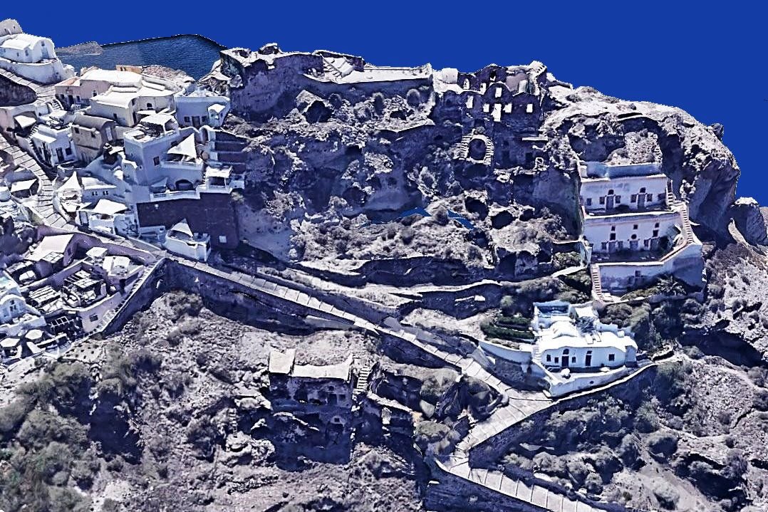
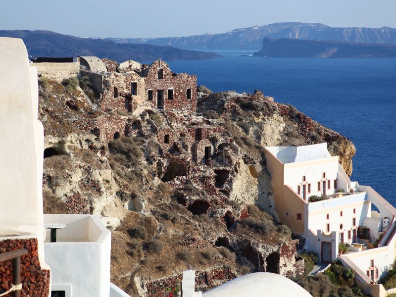
The physical disintegration of the castle was not a gradual process of a sudden, violent event. On July 9, 1956, a catastrophic 7. 5 magnitude earthquake struck the Amorgos fault line, devastating Santorini. The geological violence was particularly acute in Oia, where the unstable volcanic soil of the castle promontory sheared off into the sea. The "Goulas," which had stood for nearly five centuries, collapsed entirely, taking with it the archives of the Argyri family, the church of Agios Georgios, and the Panagia of Platsanis. The earthquake erased the medieval density of the settlement. What remains today is a fractured skeleton, a fraction of the original fortification, comprising only a section of the watchtower base and scattered remnants of the outer walls. The disaster forced a mass exodus of the population, leaving Oia and its castle in a state of abandonment that lasted until the tourism revival of the late 1970s.
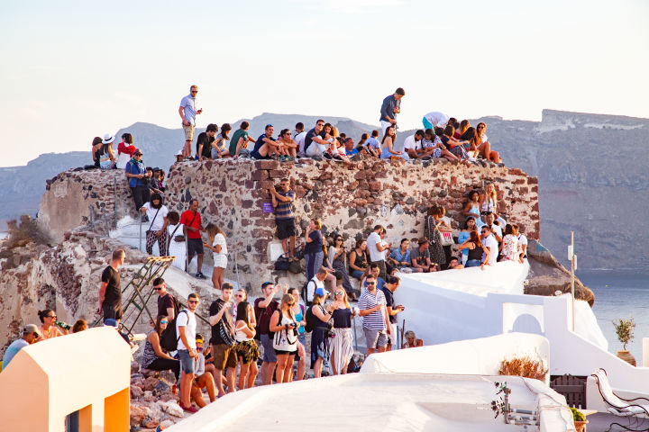
In the 21st century, the Castle of Agios Nikolaos has been repurposed by the global tourism industry into a viewing platform, creating a new form of structural stress. The ruins serve as the primary focal point for the "Oia Sunset," a commodified daily event that draws thousands of visitors to a confined, unstable geologic footprint. By 2024, reports indicated that the physical load of tourists climbing onto fragile masonry walls was accelerating and causing minor structural failures. The site, technically an archaeological monument, absence the rigorous access controls found at Akrotiri, leading to unregulated foot traffic that grinds down the soft volcanic stone. Preservationists have repeatedly warned that the sheer weight of the crowds, combined with the vibrations from constant movement, poses a serious risk to the remaining cliffside integrity.
The year 2025 marked a turning point in the management of the site, driven by acute "saturation" metrics. Mayor Nikos Zorzos implemented a daily cap of 8, 000 cruise ship passengers to mitigate the crush of bodies that chokes the narrow alleys leading to the castle. Yet, the economic data from the second quarter of 2025 revealed a paradox: while physical crowding remained high, revenue in Santorini's accommodation sector dropped by 22. 1% compared to the previous year. This decline was attributed to a combination of "overtourism" reputation scaring away high-spending independent travelers and a seismic swarm in February 2025 that reignited fears of geological instability. The castle, therefore, stands at the center of a modern conflict between preservation and exploitation, where the very crowds seeking to capture its image are actively degrading its physical structure.
Current preservation efforts are minimal and reactive. Unlike the meticulous restoration of the captains' houses in the village proper, the castle ruins are largely left to the elements. A 2023 structural assessment highlighted the "perilous" state of the cliff edge, suggesting that further collapse is inevitable without significant intervention. The local municipality faces a gridlock of jurisdiction between the Ministry of Culture, which oversees archaeological sites, and the local government, which manages the pedestrian flow. As of early 2026, no detailed reinforcement plan has been funded, leaving the Castle of Agios Nikolaos to rely on the temporary stability of the caldera face. The site remains a dangerous juxtaposition: a crumbling medieval relic supporting the weight of a modern industrial tourism economy.
Timeline of Structural and Economic Shifts: Castle of Agios Nikolaos (1480, 2026)
Period
Primary Function
Key Event / Status
Structural Condition
1480, 1700
Defensive Fortification
Construction by Dargent family; refuge from pirates.
Intact, high-density vertical settlement.
1700, 1850
Administrative & Maritime Hub
Rise of shipowners; expansion outside walls.
Maintained, residential focus shifts outward.
1956
Disaster Zone
July 9 Earthquake (7. 5 Magnitude).
Catastrophic collapse of the Goulas and cliff face.
1970, 2010
Abandoned Ruin / Scenic Spot
Slow rise of tourism; unmanaged access.
Rapid due to neglect and wind.
2010, 2024
Global Tourism Hotspot
Explosion of social media tourism.
Accelerated degradation from foot traffic.
2025, 2026
Regulated Zone
8, 000 passenger cap; revenue decline (Q2 2025).
Structurally perilous; active monitoring.
The maritime history of the castle area in the late 18th century provides essential context for its current prestige. The bay of Ammoudi, directly the castle, served as the loading dock for the island's wine trade. Venetian archives from the 1790s record a bustling trade network linking Oia to Odessa and Alexandria. The wealth generated during this period allowed the local elite to import Italian furniture, Russian silverware, and Ottoman carpets, creating a cosmopolitan interior life that contrasted with the clear, defensive exterior of the castle. This era of prosperity ended with the advent of steamships, which the shallow draft of Oia's bays could not accommodate, leading to a slow economic strangulation that predated the 1956 earthquake. The castle's ruin is thus a monument to two distinct collapses: the economic obsolescence of the sailing fleet and the geological destruction of the cliff.
By 2026, the narrative of the Castle of Agios Nikolaos has become one of resource management. The "resource" is no longer security or wine, the view. The friction between the site's capacity and the demand for access has led to the installation of turnstiles and ticketed entry proposals, concepts that would have been alien to the Venetian lords who built the walls to keep people out, not to charge them to get in. The castle's survival depends on a delicate balance: limiting human presence to prevent the remaining stones from sliding into the caldera, while maintaining the visual access that drives the island's economy. The 2025 revenue drop serves as a warning that the site's allure is not invincible; the degradation of the visitor experience through overcrowding is as destructive to Oia's future as the seismic faults that lie beneath it.
Merchant Fleet Expansion and the 19th-Century Maritime Economy
Venetian Fortifications and the Castle of Agios Nikolaos (1480, 1800)
The transformation of Oia from a fortified outpost to a maritime powerhouse began not with a shift in local geology, with a stroke of a pen in a distant tent. The Treaty of Küçük Kaynarca, signed in 1774 following the Russo-Turkish War, forced the Ottoman Empire to grant Russia the right to protect Orthodox Christians within its borders. Crucially, it allowed Greek shipowners to fly the Russian flag. For the captains of Apanomeria (Oia), this was a license to print money. Shielded by the naval power of the Tsar, Oia's merchant fleet could navigate the Black Sea without Ottoman harassment, opening a direct trade artery between the volcanic vineyards of Santorini and the grain markets of Southern Russia.
By the early 19th century, the defensive posture of the Venetian era had been abandoned. The village expanded outward along the caldera ridge, shedding its walls to build the neoclassical mansions that define its modern silhouette. This architectural shift was financed entirely by the maritime trade. The bay of Armeni, located directly the settlement, evolved into a specialized shipyard. Here, shipwrights constructed the brikia (brigs) and schooners that would dominate the eastern Mediterranean. These vessels were agile, two-masted ships capable of navigating the treacherous currents of the Dardanelles while carrying heavy cargoes of wine and pumice.
The primary export was Vinsanto, the sweet, sun-dried wine of Santorini. While the Catholic West had long consumed it, the Russian Orthodox Church became its most voracious buyer, using the deep amber liquid for Holy Communion. The Oia merchants secured a near-monopoly on this supply chain. They exported Vinsanto to Odessa and Taganrog, where it was exchanged for Ukrainian grain and high-grade timber, resources entirely absent on the barren volcanic rock of Santorini. This trade loop created a surplus of wealth that stratified the society of Oia into two distinct classes: the karavokyrides (shipowners) and the pliruma (crews).
The physical layout of the village today remains a fossilized map of this 19th-century class war. The shipowners built the "Kapetanospita", imposing, pastel-colored mansions with high ceilings, flat roofs for collecting rainwater, and marble verandas. These structures were constructed on the flat crest of the caldera to signal dominance. Conversely, the sailors and lower classes inhabited the "Hyposkapha," the cave houses dug into the vertical cliff face. These dwellings relied on the thermal insulation of the volcanic soil to survive the summer heat absence the ventilation and sanitation of the captains' quarters above. The distinction was absolute: the owners lived on the island; the workers lived in it.
The mid-19th century introduced a second commodity that rivaled wine in profitability: Theraic earth. The excavation of the Suez Canal (1859, 1869) required massive quantities of hydraulic cement capable of hardening underwater. Santorini's volcanic ash, rich in pozzolana, was the perfect additive. Oia's fleet mobilized to transport thousands of tons of this soil to Egypt. The extraction left deep scars in the island's topography, visible today as the sheer vertical cuts in the mines near the caldera edge. This period marked the zenith of Oia's maritime influence, with the village reportedly fielding over 130 merchant vessels by 1880, a density of ownership that rivaled the major ports of Syros and Hydra.
Maritime Economic Indicators: Oia (1850, 1900)
Metric
Data Point
Economic Implication
Primary Export
Vinsanto (Wine)
High-margin luxury good; religious monopoly in Russia.
Subsistence and construction; island was non-arable.
Fleet Composition
Brigs, Schooners
Optimized for speed and shallow Black Sea ports.
Key Families
Nomikos, Sigalas, Darzentas
Consolidated wealth; later transitioned to steam/finance.
The transition from sail to steam in the late 19th century proved to be a filter that destroyed the smaller players. While wind was free, coal was expensive. The operational costs of steamships required capital reserves that independent captains in Oia did not possess. Families like the Nomikos and Sigalas dynasties successfully made the leap, moving their headquarters to Piraeus or London and purchasing steel-hulled steamers. The Sigalas family, for instance, earned the moniker "Karvounaki" (Little Coal) for their early dominance in transporting coal from the Black Sea, a fuel source that eventually powered their own demise as sailing merchants. Those who clung to the canvas sails found themselves outpaced and underpriced, leading to a slow economic asphyxiation of the village.
By the early 20th century, the maritime economy of Oia was already fracturing. The Bolshevik Revolution of 1917 delivered a catastrophic blow, severing the trade link with Russia. The Soviet Union closed its markets to religious luxury goods, and the demand for Vinsanto evaporated overnight. Oia's fleet, built specifically for this route, was suddenly redundant. The captains who had not diversified into international bulk shipping faced bankruptcy. The village began a slow decline into depopulation, a process accelerated by the shift of maritime logistics to the central port of Piraeus on the mainland.
The final nail in the coffin of the maritime era was the 7. 7 magnitude earthquake of 1956. The tremor centered near Amorgos devastated Oia, collapsing both the cliff-side cave houses and the ridge-top mansions. The destruction was so severe that the Greek government encouraged the remaining population to emigrate to Athens or abroad. The merchant fleet was long gone, and the infrastructure that supported it, the shipyard at Armeni, the wine presses, the warehouses, lay in ruins. For two decades, Oia existed as a ghost town, its population dwindling to fewer than 300 residents by the 1970s.
This desolation, yet, preserved the architectural shell of the 19th-century boom. When tourism began to accelerate in the 1980s, the ruins of the Kapetanospita were not bulldozed restored. The very structures built by the Vinsanto trade were repurposed as luxury suites. The maritime history of Oia is curated in the Naval Maritime Museum, housed in a restored 19th-century mansion. Yet, the museum functions less as a living memory and more as a tomb for an era when Oia was a protagonist in global trade, rather than a passive backdrop for it. The economic model has inverted: in 1890, Oia exported local products to the world; in 2026, it imports the world to consume its local "views."
The legacy of the fleet remains in the social fabric of the families who left. The Nomikos family, having transitioned to steam and later modern bulk carriers, remains a significant force in global shipping, though their operations are no longer commanded from the cliffs of Oia. The village itself has become a stage set, where the aesthetics of the 19th-century merchant class are sold to tourists who are largely unaware that the marble beneath their feet was paid for by the Russian Orthodox Eucharist and the cement of the Suez Canal. The "Captain's Houses" are hotels, and the "Sailors' Caves" are honeymoon suites, commanding prices that would have baffled the crews who once slept in them.
Architectural Stratification: Kapetanospita versus Yposkafa Cave Dwellings
The architectural stratification of Oia is not an aesthetic choice; it is a fossilized class war. From the mid-18th century until the devastating earthquake of 1956, the village functioned as a vertical hierarchy where altitude correlated directly with net worth. The shipowning elite, or *karavokyrides*, occupied the flat, stable ground along the caldera rim, constructing the *Kapetanospita* (Captain's Houses). Beneath them, literally and socially, the crews, sailors, and laborers inhabited the *Yposkafa* (cave houses), dug into the precarious vertical face of the volcanic slag. This division dictated every aspect of construction, from the sourcing of materials to the structural response during seismic events. The *Kapetanospita*, built primarily between 1850 and 1920 during the zenith of Oia's maritime prosperity, represent a rejection of local topography in favor of European projection. These structures are characterized by strict geometry, neoclassical symmetry, and the use of imported materials that signaled access to international markets. While the poor dug into the earth, captains imported timber from Russia and marble from Naxos and Paros. The use of timber for flat roofs and second-story floors was a distinct status symbol in a treeless archipelago. These mansions, concentrated in the Sideras neighborhood, featured high ceilings, cross-vaulted cisterns for water collection, and walled courtyards (avles) that separated the private domain from the public street. The masonry used red and black volcanic stones, unlike the peasant dwellings, these were hewn into regular blocks and covered in smooth plaster to mimic the urban aesthetics of Athens or Venice. In sharp contrast, the *Yposkafa* were born of poverty and geological opportunism. absence the capital to buy land or import wood, the lower classes exploited the unique properties of the *aspa*, the dense mixture of volcanic ash, pumice, and pozzolan that forms the cliff face. Construction was a subtractive process rather than an additive one. Workers used hand tools to excavate horizontal tunnels into the cliff, creating long, narrow living spaces that required no structural timber. The structural integrity relied on the vaulted arch, a need of physics rather than style, which transferred the immense load of the overlying rock down to the sidewalls. The excavated material was not discarded; it was mixed with lime to create *Theraic earth*, a hydraulic mortar of exceptional strength that hardens over time when exposed to humidity. This allowed the poor to build with zero material cost, trading labor for shelter. The thermal performance of these two typologies differs radically. The *Kapetanospita*, with their thin walls and exposure to the elements on all sides, suffered from thermal fluctuation, requiring coal braziers in winter and cross-ventilation in summer. The *Yposkafa*, encased in infinite thermal mass, maintained a near-constant temperature of 16°C to 19°C year-round. Yet, this bioclimatic advantage came with a heavy penalty: dampness. Without cross-ventilation (as they had only one facade), the cave houses were dark, humid, and prone to mold, contributing to higher rates of respiratory illness among the working class. The seismic event of July 9, 1956, acted as a brutal stress test for these opposing engineering philosophies. The earthquake, measuring 7. 5 on the Richter, decimated the rigid, top-heavy *Kapetanospita*. Their unreinforced masonry walls and heavy timber roofs could not withstand the shear forces, leading to the collapse of the second stories and the destruction of the Sideras neighborhood. The *Yposkafa*, conversely, demonstrated a higher survival rate due to the ductility of the rock and the monolithic nature of the excavation. While the facades frequently sheared off, leaving the interiors exposed like dollhouses, the vaulted tunnels themselves largely remained intact. Even with their structural survival, the psychological trauma and the risk of landslides forced a mass abandonment of the cliffside, leaving Oia a ghost town for two decades. The resurrection of Oia began in 1976 under the Greek National Tourism Organization (EOT), which launched a preservation program to restore the settlement. Architects like Aris Konstantinidis and Voula Didoni focused on the *Yposkafa*, recognizing their unique spatial qualities. This intervention catalyzed a complete economic inversion that through 2026. The damp, dark caves of the 19th-century poor have been repurposed into the most expensive real estate assets in the Cyclades. The absence of windows, once a marker of poverty, is marketed as "privacy" and "sensory deprivation" for high-net-worth tourists.
Real Estate Valuation Reversal: Oia (1960 vs. 2026)
Property Type
1960 Status (Post-Quake)
1960 Value (Approx.)
2026 Status
2026 Value (Prime Caldera)
Kapetanospita
Ruined / Unstable
Sold for "a tin of oil" or abandoned
Luxury Retail / Boutique Hotels
€6, 500, €8, 000 / m²
Yposkafa
Condemned / Hazardous
Zero / Negative Value
Ultra-Luxury Suites
€9, 000, €12, 000+ / m²
As of early 2026, the average asking price for caldera-front properties in Oia exceeds €10, 000 per square meter, with specific *yposkafa* units commanding even higher premiums due to their scarcity and income-generating chance on short-term rental platforms. The architectural stratification remains, the hierarchy has flipped: the subterranean dwellings of the crew generate more revenue per square foot than the mansions of the captains who once commanded them. This gentrification has hollowed out the local population, turning the architectural heritage into a purely transactional commodity where the "vernacular" is preserved only as a stage set for transient consumption.
Seismic Destruction and Depopulation Following the 1956 Amorgos Earthquake
Merchant Fleet Expansion and the 19th-Century Maritime Economy
At 05: 11 AM on July 9, 1956, the geological stability of the South Aegean collapsed. A seismic event of magnitude 7. 7 $M_w$, the strongest recorded in Greece during the 20th century, ruptured a fault line south of Amorgos. While the epicenter lay approximately 40 kilometers northeast of Santorini, the shockwaves struck the caldera rim with devastating precision. Thirteen minutes later, a catastrophic aftershock of magnitude 7. 2, centered directly within the Santorini-Anafi basin, delivered the fatal blow to the settlement of Oia. This twin seismic assault did not damage the village; it terminated its existence as a functioning maritime community for the two decades. The destruction in Oia was disproportionately severe compared to other settlements on the island. This resulted from the specific lithology of the northwestern caldera rim. Oia sits atop a precarious of reddish volcanic slag and unconsolidated scoria, unlike the more basaltic formations found elsewhere. When the shear waves from the Amorgos event hit this loose aggregate, the ground underwent a process similar to liquefaction. The traditional *yposkafa*, cave houses carved directly into the cliff face, did not crumble so much as they sheared off the cliffside. Entire neighborhoods, including the remaining structures of the Venetian Castle of Agios Nikolaos, slid into the sea or collapsed inward, burying inhabitants under tons of volcanic debris. Eyewitness accounts from the period describe a deafening roar rising from the caldera, followed by a massive cloud of dust that enveloped the island, leading survivors to believe the volcano itself had erupted. In the chaos, the physical geography of Oia changed permanently. The intricate network of cobblestone route and stairways connecting the upper village to the port of Armeni was severed. The port itself, once a bustling hub for wine exports to Russia and Alexandria, suffered irreparable structural failure, rendering it useless for large- commerce. The human and structural toll was absolute. Official records from the Greek state indicate that across the island, 53 people died and over 100 sustained serious injuries. In Oia, the ratio of destruction was catastrophic.
The immediate aftermath triggered a demographic collapse known locally as the "Great Exodus." The psychological trauma of the event, combined with the total loss of economic infrastructure, forced the remaining population to flee. Unlike previous migrations which were driven by economic ambition, this was a flight for survival. Most families relocated to the port city of Piraeus or the suburbs of Athens, specifically to neighborhoods like Kokkinia and Tavros, where the state provided emergency housing. For twenty years following the catastrophe, Oia remained a ghost town. The "Time of Troubles," as older residents refer to the period between 1956 and 1976, saw the settlement reduced to a scavengers' yard. The few hundred inhabitants who refused to leave lived in the shells of ruined mansions, frequently without electricity or running water. The value of property plummeted to virtually zero. Real estate transactions from this era were frequently settled for negligible commodities; a common anecdote from the 1960s cites entire properties changing hands for "a tin of olive oil" or a donkey, as owners sought to divest themselves of tax liabilities on ruined structures. This abandonment, paradoxically, saved Oia from the architectural malpractice that plagued other Greek destinations during the junta era (1967, 1974). While other towns were rapidly rebuilt with cheap reinforced concrete and modern aesthetics, Oia lay dormant. The rubble remained where it fell. This preservation by neglect meant that the original urban fabric, the, the curvature of the vaults, the organic layout, remained intact, albeit shattered. The trajectory of Oia changed in 1976 with the intervention of the Greek National Tourism Organization (EOT). Under the program "Preservation and Development of Traditional Settlements," the state identified Oia not as a disaster zone to be cleared, as a cultural asset to be stabilized. A team of architects and engineers initiated a massive restoration project that prioritized historical fidelity over modernization. They used gunite (sprayed concrete) to reinforce the crumbling volcanic soil and stabilize the cave houses without altering their external geometry. This decision marked the beginning of Oia's second life. The EOT project converted ruined captains' houses into guest houses, creating a model for heritage tourism that prioritized high-value, low-volume visitation, a strategy that would eventually be overwhelmed by mass tourism in the 21st century. In 1976, yet, the goal was simply to arrest the decay. The restoration was meticulous; architects studied old photographs to recreate the specific plaster techniques and color palettes of the pre-1956 settlement. The 1956 earthquake serves as the definitive dividing line in Oia's history. It severed the village's link to its maritime past and its agricultural economy. The Oia that emerged from the dust of July 9 was no longer a community of sailors and winemakers. It was a blank canvas, depopulated and ruined, waiting to be reinvented as a global icon. The 306 souls recorded in the 1977 census represented the absolute bottom of a demographic curve that had started falling with the decline of sail shipping in the late 19th century. The earthquake did not start the decline, it brutally accelerated the end of the old world. Current geological surveys continue to monitor the instability of the caldera rim. The very soil composition that amplified the destruction in 1956 remains a primary hazard. Engineering reports from 2020 to 2026 indicate that while the restored buildings are structurally sound, the cliff face itself is subject to and chance landslides. The luxury hotels that crowd the cliff edge sit on the same "unconsolidated scoria" that failed seventy years ago, held in place by deep anchoring and constant maintenance. The memory of the "Zembezia", the local term for the great shake, remains in the town's foundations, a silent reminder that the breathtaking terrain of Oia is the product of violent instability.
Greek National Tourism Organization Reconstruction Projects (1976, 1990)
The 1956 Amorgos earthquake, a magnitude 7. 7 tectonic convulsion, left Oia in a state of skeletal ruin. For two decades, the settlement functioned as a necropolis of volcanic stone; its population hemorrhaged to the mainland or the safer, flatter terrain of Athens. By 1975, the caldera rim was a jagged silhouette of collapsed "yposkafa" (cave houses) and debris-choked captains' mansions. The Greek state faced a binary choice: abandon the treacherous cliffside entirely or engineer a radical resurrection. They chose the latter, initiating one of the most ambitious architectural preservation experiments in Mediterranean history. In 1976, the Greek National Tourism Organization (EOT) launched the "Preservation and Development of Traditional Settlements" program. Aris Konstantinidis, a modernist architect who had previously headed the EOT's Technical Service, returned to direct this specific initiative. His philosophy was rigid and clear: the reconstruction would not impose foreign neoclassical fantasies would instead honor the "anonymous architecture" of the island. Konstantinidis viewed the builder-less, organic evolution of the Cycladic village, shaped solely by need, wind, and volcanic soil, as the highest form of design. Under his directive, the Oia project rejected the concrete-heavy, hotel-block model that was simultaneously disfiguring parts of the Spanish and Italian coasts. The technical execution of this mandate required a forensic method to geology and history. The EOT team, rather than flattening the ruins, reinforced the precarious cliff face with gunite and grouting, stabilizing the soft Theraic earth that housed the cave dwellings. The reconstruction prioritized the *yposkafa*, the humble, vaulted dwellings of the crewmen, over the grander, surface-level *kapetanospita* (captains' houses). This decision was pragmatic as well as aesthetic; the thermal insulation properties of the volcanic soil made these subterranean chambers energy- and naturally cool. Local materials were strictly mandated: red and black volcanic stone, pozzolanic mortar, and the distinct absence of ornamentation that defined the village's vernacular style. The transformation was rapid and garnered immediate international acclaim. In 1979, only three years into the project, Oia received the Europa Nostra Diploma of Merit. The citation praised the "superb rehabilitation of the old village... to form a tourist area, while preserving its existing character." This was followed in 1986 by the Prize of the Sofia Biennale of Architecture. These accolades validated the EOT's strategy of "museumification", turning the settlement itself into a living exhibit. The project succeeded in its primary metric: it halted the physical disintegration of the village. Yet, the social engineering component of the project produced a complex. The EOT's original intent was to revitalize the settlement for residents, the restoration inadvertently created a vacuum that only high-end tourism could fill. The "traditional hostels" established by the EOT became the prototypes for the luxury boutique hotels that would later dominate the caldera. By 1990, the demographic shift was undeniable. The families who had fled in 1956 did not return to live; they returned to sell. The very architectural purity preserved by Konstantinidis and his team became the primary asset of a new, extractive economy, turning the silent, recovered ruins into one of the most expensive real estate markets in the Aegean.
Restoration of "Traditional Settlements" (Oia, Vathia, Mesta)
Key Architectural Focus
Stabilization of yposkafa (cave houses)
International Awards
Europa Nostra (1979), Sofia Biennale (1986)
Bed Capacity Added
~680 beds (across all program settlements by 1991)
Economic Outcome
Transition from depopulated ruin to luxury tourism zone
Cruise Tourism Metrics and Carrying Capacity Violations (2010, 2026)
Architectural Stratification: Kapetanospita versus Yposkafa Cave Dwellings
The Venetian fortifications of Oia, constructed in the late 15th century to repel marauding pirates, face a siege of a different nature: the daily disembarkation of thousands of cruise passengers. While the Castle of Agios Nikolaos once housed a population living in fear of abduction, the modern settlement struggles to contain a transient population that frequently exceeds the island's physical and social carrying capacity. Between 2010 and 2026, Oia transformed from a high-end destination into a case study for "overtourism," a phenomenon where the volume of visitors actively degrades the infrastructure, environment, and resident quality of life. The metrics defining this era show a trajectory of unchecked growth, regulatory failure, and a belated, desperate attempt to regain control through taxation and scheduling algorithms.
Data from the Hellenic Ports Association reveals the of this influx. In 2019, a benchmark year for pre-pandemic travel, Santorini received 592 cruise ship calls delivering approximately 980, 000 passengers. Following a brief pause during the global health emergency, these numbers did not recover; they surged. By the end of 2023, the island recorded 800 cruise ship arrivals with 1. 29 million passengers. Preliminary data for 2024 indicates a further increase to 1. 35 million passengers, even with a slight reduction in ship calls, as vessels became larger and sailed at higher occupancy rates. This volume creates a specific, acute pressure on Oia, which serves as the primary excursion point for the "sunset spectacle." While the port of entry is at the base of the caldera near Fira, the logistical flow funnels the majority of these day-trippers directly to the northern tip of the island, saturating the narrow, 3-meter-wide alleyways of Oia.
The concept of "carrying capacity" moved from academic theory to legislative need following a 2018 study by the University of the Aegean. Led by Professor Maria Lekkakou, the research determined that Santorini's infrastructure, specifically its water supply, waste management, and road network, could sustain a maximum of 8, 000 cruise passengers per day. This figure became the basis for a widely publicized "cap" intended to distribute arrivals. Yet, the implementation of this limit proved porous. The Berth Allocation System, designed to space out ship arrivals, frequently failed to account for the size of modern mega-liners. In July 2024, the system's failure became public when Panagiotis Kavallaris, a senior municipal official, posted a controversial advisory on social media urging residents to limit their movements because 17, 000 cruise passengers were expected to disembark in a single day. This admission, that residents should enter lockdown to accommodate tourists, exposed the collapse of the 8, 000-passenger limit.
Santorini Cruise Tourism Metrics & Regulatory Status (2019, 2026)
Year
Ship Calls
Total Passengers
Daily Peak Volume
Regulatory Context
2019
592
980, 771
~10, 000
Pre-regulation baseline.
2023
800
1, 298, 968
~15, 000
Post-pandemic surge; cap ignored.
2024
~750
1, 350, 000 (Est.)
17, 000
"Stay Home" advisory issued to locals.
2025
Projected
Forecast +10%
8, 000 (Target)
€20 "Sustainable Tourism Fee" implemented.
2026
Projected
Stabilization
Strict Cap
100% occupancy calculation enforced.
The impact of these numbers is most visible in Oia's infrastructure, which was built for a 19th-century agrarian society, not a 21st-century mass tourism hub. The village relies on desalination plants for fresh water, the energy required to pump this water to the settlement's altitude places an immense load on the electrical grid. During the sunset hour, when thousands of tourists occupy the castle ruins and surrounding terraces, the demand for electricity (for air conditioning in hotels and lighting for businesses) peaks simultaneously with the water demand. This has led to sporadic blackouts and reduced water pressure, incidents that local authorities frequently attribute to "technical faults" which correlate directly with peak visitor density. The sewage system, largely dependent on septic tanks and a limited central network, faces similar, with leakage incidents reported in the lower pedestrian zones during high season.
The economic argument for this volume, that cruise passengers drive local revenue, faces scrutiny when examining the specific spending behaviors in Oia. Unlike overnight guests who contribute to hotels and evening dining, cruise passengers spend less than five hours on the island. Their consumption is frequently limited to low-margin items such as water, ice cream, and souvenirs, yet their physical presence consumes the same amount of public space and infrastructure as high-yield visitors. This prompted the Greek government to intervene. In 2024, Prime Minister Kyriakos Mitsotakis announced a new pricing structure affecting Santorini and Mykonos. Starting July 1, 2025, a levy of €20 per passenger applies during the peak season (June to September). This fee aims to dampen demand and generate funds for infrastructure repair, though industry analysts that for a passenger paying €2, 000 for a cruise, a €20 fee is unlikely to act as a deterrent.
The "sunset bottleneck" in Oia presents a unique spatial problem that aggregate island-wide data obscures. Even if the daily cap of 8, 000 is strictly enforced, the temporal concentration remains. Nearly all cruise passengers depart their ships with the specific intent of viewing the sunset from Oia. This results in a crowd density of up to 4, 000 people packing into the ruins of the Castle of Agios Nikolaos and the adjacent 300-meter stretch of cliffside pathway. This density creates a safety hazard; in the event of a medical emergency or a minor seismic event (common in this volcanic zone), evacuation would be impossible. The physical of the castle ruins, accelerated by thousands of footsteps daily, has forced the municipality to cordon off sections of the monument, further reducing the available standing room and increasing the crush density in the remaining areas.
Looking toward 2026, the strategy shifts from simple numerical caps to more sophisticated slot management. The Ministry of Tourism and the Hellenic Ports Association have revised the berth allocation algorithm. Previously, a ship with a capacity of 3, 000 might be counted as 2, 400 passengers based on an 80% occupancy assumption. For the 2025-2026 seasons, the calculation assumes 100% occupancy, reducing the number of allowed ships. Also, the new regulations impose stricter penalties for slot misuse. Yet, the challenge remains the road network connecting the port to Oia. The bus transfer system requires a fleet of 40-50 coaches to move passengers from the Athinios port to Oia, clogging the island's single main artery and paralyzing local traffic for hours each morning and evening. The carrying capacity is not just a measure of how people can stand on the castle walls, how vehicles the road to the castle can physically accommodate.
The historical irony is sharp. In the 1700s, the gates of the Kasteli were locked at sunset to keep invaders out. In 2026, the "invaders" are invited in, the gates are jammed by the sheer mass of bodies. The preservation of Oia depends not on fortification walls, on the rigorous enforcement of data-driven entry limits and the willingness of the state to prioritize the integrity of the settlement over the volume of arrivals.
Desalination Dependency and Potable Water Infrastructure Strain
For nearly three centuries following the Venetian era, Oia's survival depended on a hydro-geological paradox: the settlement existed on an island with no rivers, no lakes, and a water table compromised by geothermal salinity. Between 1700 and the mid-20th century, the population practiced a strict "water poverty," relying entirely on sterna, underground cisterns carved into the volcanic rock to capture winter rainfall. These bell-shaped reservoirs, lined with a mixture of lime and Theran earth (pozzolan), were not architectural features the primary engine of habitation. A 19th-century inventory of Oia records that the volume of a household's cistern frequently determined the property's value more than the dwelling's square footage. The system was unforgiving; a dry winter meant rationing that could last for eighteen months.
The transition from this closed-loop rainwater economy to industrial desalination began in the late 1980s, driven not by resident population growth by the explosive rise of luxury tourism. By 2010, the traditional cisterns had largely been converted into swimming pools or decorative features, severing the settlement's connection to its meteorological reality. In their place, the Municipality of Thira (DEYATH) installed a reliance on energy-intensive Seawater Reverse Osmosis (SWRO) plants. This shift fundamentally altered Oia's resource metabolism. Where water was once a finite gift from the sky, it became a manufactured commodity, theoretically infinite bound by the physical limits of electricity and piping infrastructure.
By 2022, Oia's water supply was anchored by a dedicated SWRO unit with a nominal capacity of 2, 000 cubic meters per day (CMD). While this output appears sufficient for a village of fewer than 1, 000 permanent residents, the operational reality is distorted by the "pool economy." Investigative data from the 2023, 2024 tourist seasons indicates that a single luxury villa with a plunge pool and Jacuzzi consumes approximately 600 liters of potable water per guest per day, nearly four times the average consumption of a permanent resident. The infrastructure, designed for domestic municipal use, functions primarily as a commercial feedstock for the hospitality sector.
The fragility of this artificial abundance was exposed during the "May emergency" of 2025. Following a period of low rainfall and a sudden influx of early-season tourists, the Oia desalination plant suffered a serious failure in its seawater intake system. On May 28, 2025, DEYATH was forced to announce emergency interruptions, leaving the wider Oia area and fourteen other settlements with little to no water pressure. The emergency was not mechanical; it was a widespread collapse of reserves. The municipal tanks, which should have held a multi-day buffer, were depleted by "excessive consumption" that outpaced the plant's production rate. For forty-eight hours, one of the world's most expensive destinations had no running water, a failure that Mayor Nikos Zorzos later as proof that the island had reached "saturation."
The is compounded by the physical degradation of the distribution network. A 2025 infrastructure audit revealed that Santorini loses approximately 45% to 50% of its desalinated water to leakage before it reaches the consumer, a figure nearly double the European Union average. In Oia, where pipes are buried beneath centuries-old cobblestones and volcanic slag, repair is logistically nightmarish. The water that does reach the tap is the product of an immense energy expenditure. Desalination on Santorini is powered largely by the local oil-burning power station, creating a feedback loop where water production drives carbon emissions, which in turn exacerbate the regional aridity that desalination.
Oia Water Infrastructure Metrics (2020, 2026)
Metric
2020 Data
2025 Data
Change
Daily Water Demand (Peak Season)
~1, 800 m³
~3, 400 m³
+88%
Desalination Capacity (Oia Unit)
900 m³
2, 000 m³
+122%
Network Leakage Rate
38%
48%
+10%
Cost per Cubic Meter (Production)
€1. 80
€2. 45
+36%
The environmental cost of this dependency extends to the marine environment. The desalination process generates a highly concentrated brine byproduct, which is discharged back into the sea. In the calm waters of the caldera Oia, the dispersion of this brine is slow, leading to localized salinity spikes that threaten nearshore marine ecosystems. While no "dead zones" have been officially declared in the Ammoudi Bay area as of March 2026, marine biologists have observed a reduction in sea grass density near discharge points, a warning sign of hypoxic conditions.
As of early 2026, the situation remains precarious. The enforcement of an 8, 000-passenger daily cap for cruise ships was intended to alleviate infrastructure pressure, yet the demand for water continues to rise. The "Oia Paradox": a settlement that historically survived on less than 10 liters per person per day teeters on the brink of collapse even with producing millions of liters annually. The 2025 emergency demonstrated that no amount of engineering can indefinitely the mathematics of exponential demand in a finite space. The water flowing into the infinity pools of Oia is not desalinated seawater; it is the liquefied asset of the island's energy grid and the primary vector of its ecological debt.
Short-Term Rental Saturation and Displacement of Local Residents
Seismic Destruction and Depopulation Following the 1956 Amorgos Earthquake
The demographic collapse of Oia is not a recent phenomenon, the method of displacement has shifted from geological violence to algorithmic extraction. In 1956, the Amorgos earthquake, a 7. 5 magnitude event, shattered the settlement, forcing the surviving population to flee to Piraeus and Athens. For two decades, Oia remained a ghost town, its ruins standing as a testament to the seismic volatility of the Aegean. The current displacement, observed from 2015 through 2026, mirrors this emptiness masks it behind a veneer of luxury. While the earthquake expelled residents through physical destruction, the short-term rental (STR) market has achieved a similar result through economic exclusion. The village is no longer abandoned; it is fully occupied, yet devoid of citizens. The seeds of this transformation were planted in 1976, not by developers, by the Greek State itself. The Greek National Tourism Organization (EOT) launched a preservation program intended to save the unique Cycladic architecture from total decay. Architects and state planners identified the *yposkafa*, cave houses carved into the volcanic cliff face, as the focal point for restoration. Historically, these structures were the dwellings of the poorest class, frequently used to house donkey crews and store agricultural produce, while the wealthy captains lived in the neoclassical mansions above. The EOT project restored these caves with the specific intent of creating "traditional settlements" for paying guests. This decision, while successful in preserving the physical shell of Oia, established the economic model that would eventually consume the village: the commodification of the humble cave dwelling into a high-value tourist asset. By 2019, the saturation of Oia had reached serious mass. Data from the Hellenic Chamber of Hotels and independent analysts indicated that Santorini possessed approximately 80, 000 beds, a density per square kilometer higher than any other destination in Greece. In Oia, the ratio of tourist beds to permanent resident beds flipped aggressively. The arrival of digital platforms like Airbnb and Booking. com accelerated this trend, allowing property owners to bypass the regulatory friction of traditional hotel licensing. The *yposkafa*, once signs of poverty, became the most coveted real estate on the island, commanding nightly rates that frequently exceeded the monthly salary of a Greek public servant. The human cost of this saturation became undeniable between 2023 and 2024. Reports verified by local municipal authorities and labor unions exposed a severe housing emergency for essential workers. Teachers, doctors, and police officers assigned to Santorini found themselves unable to secure affordable accommodation. In September 2024, the President of the local teachers' association confirmed that educators were sleeping in their cars or camping on beaches because the cheapest available studios in Oia and Fira cost upwards of €700 per month, while the starting salary for a teacher hovered around €900. The Municipality of Thira was forced to intervene, appealing to residents to "adopt a teacher" and scrambling to convert old warehouses into makeshift dormitories. This marked the complete decoupling of the local economy from the local housing market; the village generated millions in revenue, yet could not house the people required to educate its children or treat its sick. The mechanics of this displacement are visible in the rental yield differentials. A long-term lease in Oia, if one could even be found, might yield €800 to €1, 200 per month. That same property, listed as a short-term rental, generates that sum in two nights during the high season. The economic incentive to evict long-term tenants is absolute. Consequently, the permanent population of Oia has dwindled to a skeleton crew, mostly elderly residents who own their homes outright, while the working-age population commutes from the less expensive, non-caldera villages of the interior or from other islands entirely.
Table 8. 1: Comparative Housing Metrics in Oia (2015, 2025)
Metric
2015 Estimate
2025 Data
Change Factor
Avg. Nightly Rate (Yposkafa)
€180
€850+
4. 7x
Long-Term Rental Availability
Low
Near Zero
-100%
Teacher Housing Deficit
Manageable
serious (Car sleeping)
N/A
Cruise Passenger Arrivals (Island-wide)
~600, 000
~1. 3 Million
2. 1x
In response to this collapse of social infrastructure, the Greek government implemented strict regulatory measures October 2025. Under Law 5170/2025, the state imposed a "Climate Resilience Duty," taxing short-term rentals at significantly higher rates, up to €15 per day during peak season, and levying a €20 fee on every cruise passenger disembarking in Santorini. Also, the government enforced a ban on new short-term rental registrations in the saturated districts of Athens, with provisions to extend these freezes to "saturated" islands like Santorini. Mayor Nikos Zorzos publicly declared that the island had reached "saturation point" years prior, advocating for a hard cap on beds. The 2025 legislation also mandated strict safety and quality standards for STRs, a move designed to force lower-quality units off the market, though critics this consolidates the market into the hands of larger property management firms. The "Golden Visa" program further exacerbated the problem before the 2024 reforms. For years, non-EU investors could purchase property valued at €250, 000 to gain residency. This threshold made the small apartments of Oia prime for foreign capital seeking a European foothold. The threshold was raised to €800, 000 for Santorini in 2024 to the bleeding, yet the damage to the local housing stock was already done. The properties had been transferred from local families to international investment portfolios, removing them permanently from the residential circulation. By early 2026, Oia functions less as a municipality and more as an open-air hotel. The "traditional settlement" designation, designed to protect the village, has paradoxically cannibalized it. The preservation laws froze the aesthetic, preventing modern construction that might have relieved housing pressure, while the market filled that frozen shell with transient visitors. The displacement is total. The descendants of the 1956 earthquake survivors, who returned to rebuild, find themselves priced out of the very ruins their families restored. The village is pristine, photogenic, and economically strong, yet it has ceased to exist as a community of citizens. It is a stage set, staffed by commuters, consumed by transients, and owned by absentees.
Caldera Slope Instability and Landslide Risk Management
The geological reality of Oia is that the settlement sits atop a vertical graveyard of volcanic debris, not a monolithic stone foundation. The caldera rim here is a stratigraphic " cake" of instability: dense, heavy lava flows (andesite and dacite) rest precariously on loose, unconsolidated pyroclastic material, specifically the reddish scoria and the Minoan tuff. This configuration creates a high-risk geotechnical environment where the harder upper, weighed down by centuries of construction, are prone to shearing off as the softer underlying or compress. The visual allure of the "Red Beach" geological equivalent found in the cliff face Oia masks a structural weakness that has dictated the town's survival since the 1700s.
The catastrophic chance of this geology was realized on July 9, 1956, when a 7. 5 magnitude earthquake struck the Amorgos fault. While the quake devastated the entire archipelago, Oia suffered disproportionately compared to other settlements. The loose volcanic soil amplified the seismic waves, a phenomenon known as the "site effect", causing the collapse of the traditional cave houses (yposkafa) carved into the cliff. Data from the event records that 529 houses were destroyed and 1, 482 heavily damaged across the region, with Oia losing of its medieval fabric. The 1956 event remains the benchmark for slope failure, proving that the caldera rim behaves like a liquid during high-intensity seismic loading.
In the 21st century, the threat has shifted from purely tectonic triggers to anthropogenic loading. The proliferation of swimming pools along the caldera edge has introduced a massive, localized weight load that the slope was never engineered to sustain. A standard 50-square-meter pool adds approximately 75 to 100 tons of water weight to the cliff edge. also, leakage from these pools and the associated hydraulic infrastructure lubricates the contact zones between rock, reducing friction and facilitating slip. By late 2024 and early 2025, this danger forced the Greek Ministry of Environment to implement a strict freeze on new construction and pool permits within the caldera zone, a regulatory admission that the terrain had reached its load-bearing capacity.
The human cost of this instability is not theoretical. On May 23, 2011, a rockfall at Ammoudi Bay, the port directly Oia, killed a 52-year-old American tourist and injured four others. The victim was struck while navigating the donkey route, a zigzagging route that cuts directly through the most unstable sections of the ignimbrite face. This incident exposed the limitations of passive protection measures; even with the installation of wire meshes and catch fences, the sheer kinetic energy of detaching boulders, frequently weighing several tons, can overwhelm containment systems. The route remains a high-risk zone, subject to sudden closures during periods of seismic swarms or heavy rainfall.
Satellite monitoring using Interferometric Synthetic Aperture Radar (InSAR) provides a granular view of the slope's movement between 2020 and 2026. Data analyzed from the Sentinel-1 constellation reveals that while the central caldera exhibited uplift (inflation) rates of up to 60mm per year during the 2024-2025 unrest, the western slopes of Oia showed subsidence and horizontal displacement of -20mm to -30mm per year. This differential movement indicates that the cliff face is slowly detaching from the main island block, a process accelerated by the volcanic inflation that pushes the island's crust outward. The ground is not static; it is breathing, and Oia is perched on the exhaling edge.
Management strategies in 2026 have moved beyond simple reinforcement to active retreat and density control. Engineering reports from 2025 emphasize that "stitching" the cliff with rock bolts is a temporary solution for a slope that is geologically destined to collapse. The focus has shifted to reducing the live load on the rim. This includes the prohibition of new "heavy" tourism infrastructure and the mandatory structural auditing of existing cave houses. The 2025 legislation requires commercial properties to prove static adequacy every two years, a bureaucratic hurdle designed to identify and condemn structures before they slide into the Aegean. The battle for Oia's stability is no longer about conquering the cliff, about managing the inevitable retreat from the edge.
7. 5 Mw earthquake;>35% of Oia housing stock destroyed due to soil amplification.
May 23, 2011
Fatal Rockfall
1 fatality, 4 injuries at Ammoudi Bay; failure of loose ignimbrite block.
2011-2012
Volcanic Unrest
Caldera inflation (14cm) triggered increased rockfall frequency along the rim.
April 2024
Landslide
Slope failure in Imerovigli/Oia zone; dust cloud covered hotels; no fatalities.
2024-2025
Regulatory Action
Ministry of Environment suspends building permits; cites pool weight as stability risk.
2025-2026
InSAR Deformation
Recorded subsidence of -20mm to -30mm/year on Oia's western slopes.
Decline of Viticulture and the Sigalas Winery Export Data
Greek National Tourism Organization Reconstruction Projects (1976, 1990)
The transformation of Oia from a maritime agrarian stronghold to a luxury accommodation zone is most violently visible in the collapse of its viticulture. Between 1700 and 1900, the northern plains of Oia, specifically the Baxes and Finikia regions, functioned as the primary engine for the island's export economy. The volcanic soil, composed of pumice and ash, necessitated a unique pruning method known as the kouloura, where vines are woven into basket shapes to protect the grapes from the ferocious meltemi winds and trap the night's sea mist. During the 18th century, Oia's captains did not transport passengers; they managed a massive trade route of Vinsanto, the island's sweet, sun-dried wine, to the Russian Empire. The Russian Orthodox Church used Santorini Vinsanto for Holy Communion, creating a direct economic pipeline between the volcanic slopes of Apanomeria and the port of Odessa. This trade brought immense wealth to Oia, funding the captain's houses that serve as boutique hotels.
The 1956 earthquake shattered this agrarian infrastructure. The seismic event destroyed the traditional canavas (underground wineries) carved into the soft volcanic rock, burying wine presses and storage barrels under tons of debris. While the village rebuilt, the economic focus shifted. By the 1980s, the rise of mass tourism introduced a lethal competitor for the land: concrete. The value of a hectare of land for hotel development quickly outpaced its chance yield in Assyrtiko grapes by orders of magnitude. Farmers, aging and without successors, sold their plots. The vineyard acreage on Santorini plummeted from approximately 3, 000 hectares in the 1960s to fewer than 1, 000 hectares by 2025. In Oia, where the caldera view commands the highest real estate prices in Greece, the erasure of vineyards was particularly aggressive.
Paris Sigalas, a mathematician turned winemaker, established Domaine Sigalas in 1991 on the plains of Oia, attempting to halt this decline through high-quality vinification. Unlike the bulk wine production of the past, Sigalas applied scientific rigor to the Assyrtiko grape, proving its chance to produce world-class dry whites with high acidity and mineral density. His facility in Baxes became the northern anchor of Santorini's wine production. Sigalas also rescued the Mavrotragano variety, a red grape nearly extinct in the 1990s, by replanting it in the Oia vineyards. Yet, the struggle against real estate development remained constant. The winery sits in the "plain" of Oia, an area that developers view as prime expansion territory for the saturated caldera rim.
The following data illustrates the catastrophic contraction of Santorini's viticulture and the inverse correlation with the cost of raw materials, a trend that accelerated violently between 2010 and 2025.
Table 1: The Collapse of Santorini Viticulture vs. Economic Valuation (2003, 2025)
Year
Total Island Production (Tons)
Grape Price (€ per kg)
Est. Vineyard Area (Hectares)
Domaine Sigalas Status
2003
5, 000
0. 60
1, 800
Capital expansion; new bottling unit active.
2010
2, 800
0. 85
1, 400
Kir-Yianni acquires 40% stake.
2018
1, 800
3. 50
1, 200
Exports reach 40 countries.
2020
1, 200
5. 00
1, 100
Kir-Yianni acquires majority control (60%).
2024
500
8. 00, 10. 00
950
Severe drought; yields drop 70%.
2025
350, 400
10. 00, 12. 00
900
Historic low yield; "Extinction" warning.
In 2020, the Boutaris family (Kir-Yianni Estate) acquired majority control of Domaine Sigalas, marking a shift toward corporate consolidation to survive the emergency. Stellios Boutaris, assuming the role of CEO, implemented aggressive export strategies, pushing Sigalas wines into 55 international markets, including the United States, Germany, and Australia. The winery produces approximately 200, 000 to 300, 000 bottles annually, a number that fluctuates wildly depending on the harvest. The 2023, 2024, and 2025 vintages represent a statistical anomaly bordering on disaster. Consecutive years of drought, combined with heatwaves exceeding 40°C, scorched the vines. The 2025 harvest yielded roughly 15% of the volume seen in 2000. This scarcity drove grape prices to heights, reaching €12 per kilogram in 2025, making Santorini grapes the most expensive in Europe.
The of these metrics are severe for Oia. The high cost of grapes forces bottle prices above €50, pushing the wine into a super-premium category that limits its market to elite consumers and tourists. Local tavernas can no longer afford to serve local PDO (Protected Designation of Origin) wine. also, the "Seven Villages" project launched by Sigalas, which isolates Assyrtiko from specific village terroirs including Oia, demonstrates the distinct salinity and phenolic content of the northern plain. This project serves as a final archival effort to map the taste of the land before it is chance lost to the concrete of luxury suites.
As of early 2026, the vineyards of Oia face an existential threat. The European Union protections for the PDO zone clash directly with the municipal zoning laws that frequently grant exceptions for "strategic tourism investments." The water emergency exacerbates the problem; while hotels rely on energy-intensive desalination plants, the vineyards are dry-farmed, relying solely on the diminishing sea mist and winter rain. Without a mandated irrigation network or a total ban on new construction in the agricultural zones of Baxes and Finikia, the 3, 500-year-old tradition of the kouloura in Oia likely within the decade, leaving Domaine Sigalas as a museum of a lost industry rather than an active producer.
Solid Waste Logistics and Landfill Capacity in a Pedestrian Zone
The visual symmetry of Oia, whitewashed cubic volumes cascading down the caldera face, conceals a logistical nightmare that begins every morning before sunrise. While the village sleeps, a different kind of traffic navigates the narrow, stepped calderimi. Before the tourist arrives to secure a vantage point for the sunset, municipal workers and mule handlers engage in a physical battle against and geology. Solid waste management in Oia is not a municipal service; it is a daily emergency of topography. The settlement's architecture, designed in the 15th century to repel pirates, repels modern sanitation infrastructure. Standard garbage trucks cannot navigate the labyrinth of stairs and 90-degree turns that define the pedestrian zone. Consequently, the removal of refuse from the luxury suites and restaurants clinging to the cliffside relies on a hybrid system of manual labor, equine transport, and, only at the village perimeter, mechanization.
To understand the severity of the 2026 waste emergency, one must examine the historical baseline. Between 1700 and 1950, Oia operated as a near-zero-waste society, not by design by need. The pre-tourism economy was agrarian and maritime. Households generated minimal inorganic refuse. Food scraps fed livestock; broken pottery was crushed for mortar (pozzolan); worn textiles became rags or insulation. The primary "waste" output was wood ash and animal manure, both of which were cycled back into the vineyards of the hinterland as fertilizer. The caldera itself served as a convenient, if environmentally reckless, sink for inert materials, the volume was negligible. The 1956 earthquake marked the major deviation from this pattern. The destruction of the castle and surrounding neighborhoods generated thousands of tons of rubble. absence heavy or a landfill, residents and the military shoved much of this debris over the cliff edge, creating underwater talus slopes that marine geologists still map today.
The introduction of mass tourism in the late 1970s and the subsequent explosion of plastic packaging in the 1990s shattered this equilibrium. By 2010, Oia was generating waste at a rate comparable to a dense urban center, yet its collection infrastructure remained stuck in the 19th century. The geography dictates that every kilogram of waste generated the rim level must be carried up. There is no -assist for trash removal in Oia; everything fights the slope. In the absence of roads, the Municipality of Thira relies on the island's mules and donkeys. While animal welfare activists frequently document the plight of these animals carrying tourists, a less visible equally grueling load is their role in the "garbage train." In the early hours, mules loaded with twin wicker baskets or plastic drums ascend the 200-plus steps from Ammoudi Bay and the lower cliffside hotels, hauling bags of wet, heavy restaurant waste to the transfer points at the top of the ridge.
The data on waste generation reveals a seasonality that breaks standard municipal planning models. In January, Oia's waste output reflects its skeleton crew of permanent residents, roughly 1, 000 people. By August, the daily population swells with over 15, 000 transients. The waste composition shifts violently from household organics to high-volume single-use plastics, glass bottles, and food waste. By 2024, the Municipality of Thira estimated that the island generated over 26, 000 tons of solid waste annually, with Oia contributing a disproportionate share per hectare due to the density of high-consumption luxury hospitality venues.
Table 11. 1: Evolution of Waste Logistics in Oia (1800, 2026)
Era
Primary Waste Composition
Collection Method
Disposal Site
1800, 1950
Organic, Ash, Ceramic, Textile
Household reuse / Manual carry
Vineyards (fertilizer) or Caldera (sea dump)
1956, 1960
Earthquake Rubble, Stone, Timber
Manual labor /
Caldera slopes / Sea floor
1980, 2010
Paper, Glass, Early Plastics
Mules / Open trucks
Alonaki (Illegal Caldera Landfill)
2011, 2020
High-volume Plastic, Food, Sludge
Mules / Compactors at rim
Alonaki (Oversaturated)
2021, 2026
Single-use packaging, Construction debris
Mules / Electric hand-carts / PPP Transfer
Integrated Waste Management Plant (Thira)
The destination of this trash has long been a source of national shame and European Union litigation. For decades, the refuse collected from Oia was trucked to the notorious "Alonaki" landfill near Fira. This site, essentially an uncontrolled dump located precariously close to the caldera rim, became a symbol of the island's infrastructure failure. It absence proper lining, leachate collection, or biogas management. In the summer heat, the stench wafted over the island's capital, and spontaneous combustion fires were common. The European Court of Justice repeatedly fined the Hellenic Republic for the continued operation of such illegal landfills (HADA), with penalties accruing into the millions of euros annually. Oia's pristine white aesthetic was maintained only by exporting its filth to this festering wound in the volcanic rock a few kilometers south.
By 2020, the situation at Alonaki was untenable. The landfill had exceeded its capacity by over 300%. The Municipality of Thira, under immense pressure from Brussels and the Ministry of Environment, initiated a Public-Private Partnership (PPP) to construct a modern Integrated Waste Management System. This facility, designed to process 30, 000 tons annually, promised to introduce recycling sorting lines, composting for organics, and sanitary burial for residues. Yet, the transition was with delays. Between 2022 and 2025, Oia operated in a "transitional management" limbo. The municipality introduced "Pay-As-You-Throw" pilot programs for commercial businesses, attempting to force hotels to reduce their packaging footprint. Compliance was spotty. The sheer logistical difficulty of weighing trash bags hauled by mule at 5: 00 AM made enforcement nearly impossible.
In 2026, the logistics of solid waste in Oia remain a friction point between the 17th-century town plan and 21st-century consumption habits. The new waste processing plant is operational, closing the Alonaki chapter, the " mile" problem remains unsolved. Electric crawler carriers, small, treaded vehicles capable of climbing stairs, have been tested as a replacement for mules. These machines, yet, struggle with the irregular heights of the Venetian-era steps and the slick surface of the marble-paved main thoroughfare. Consequently, the mule remains the primary engine of sanitation. The clash is visceral: tourists paying €1, 500 a night for a caldera view frequently wake to the sound of hooves and the smell of refuse being marshaled up the cliff. The municipality has attempted to mitigate this by enforcing strict "garbage hours" ( 2: 00 AM to 6: 00 AM), turning the village into a frenetic construction and sanitation zone under the cover of darkness.
Recycling rates in Oia also suffer from the topography. Standard "blue bin" recycling trucks cannot enter the village. This forces residents and businesses to manually separate and carry recyclables to the peripheral parking lots, a disincentive that leads to high rates of contamination. Glass bottles, heavy and voluminous, are a particular plague. In 2025, a local initiative began crushing glass on-site at hotels to reduce volume, the noise pollution laws quickly curtailed the practice. The result is that a significant percentage of recyclable material from Oia still ends up in the general waste stream, bypassing the expensive sorting technology at the new plant.
The construction waste generated by the endless renovation of cave houses adds another of complexity. Since heavy is banned and physically impossible to use, every bag of cement and every chunk of demolished volcanic rock must be carried by hand or animal. This creates a shadow economy of illegal dumping, where renovation debris is sometimes surreptitiously mixed with municipal solid waste or, in worse cases, scattered in the ravines behind the village, hidden from the view of the sunset-gazers. The geological instability of the caldera rim is thus exacerbated by the very process of maintaining the structures built upon it.
2026 Municipal Zoning Reforms and Visitor Entry Quotas
The year 2026 marks the definitive end of Oia's era as an unrestricted open-air museum. Following the seismic emergency of early 2025, where a swarm of 25, 000 tremors between January and February destabilized both the caldera cliffs and the local tourism economy, municipal authorities enforced the most aggressive zoning and entry reforms in the settlement's 600-year history. The "Saturation Law," fully operational as of January 1, 2026, reclassifies the entire Oia-Thirassia caldera arc from a "Tourism Development Zone" to a "Strict Control Zone." This legislative pivot freezes the built environment in amber, prohibiting new construction, swimming pool excavation, and hotel expansions. The logic is geological as much as it is social: the volcanic slag that supported the Venetian fortifications of 1480 can no longer sustain the hydraulic weight of 21st-century infinity pools. The most visible method of this new regime is the "Berth Allocation System," a digital gatekeeper that strictly enforces the daily cap of 8, 000 cruise passengers for the entire island. While the cap was theoretically introduced in 2025, the 2026 iteration removes the previous 80% occupancy loophole., a ship with a capacity of 3, 000 passengers counts as 3, 000 entries against the daily limit, regardless of actual manifest numbers. This algorithmic rationing has decimated the "peak hour" congestion that previously saw 17, 000 daily visitors choke the marble pedestrian spine of Oia. also, the implementation of the €20 "Climate Resilience Fee" per cruise passenger during the peak season (June to September) has created a financial barrier that filters out low-yield tourism. This fee, collected directly by port authorities, is earmarked for serious infrastructure stabilization, specifically the reinforcement of the crumbling pumice slopes beneath the Castle of Agios Nikolaos. These measures represent a return to the settlement's defensive origins. In the 1700s, Oia (then Apanomeria) was a fortified *Kasteli* where entry was restricted by heavy wooden gates to protect residents from pirate raids. In 2026, the gates are digital, and the threat is not piracy capacity. The Special Urban Plan (EPS) unveiled by the Ministry of Environment and Energy has shrunk the island's eligible tourism development zones from 59. 8% of the land area to a mere 6. 8%. For Oia, this means the "gold rush" of converting 19th-century maritime caves into luxury suites is legally over. The moratorium extends to the "hyposkapha" (cave houses), preventing any further excavation into the caldera face. This creates a hard cap on the settlement's population density, fixing the number of available beds to the 2024 census levels. The infrastructure data from May 2025 justifies these draconian measures. During a "mud rain" event that month, the simultaneous cleaning of thousands of patios and pools caused a catastrophic pressure drop in the municipal water network, leaving 15 villages, including parts of Oia, without water for 48 hours. The incident exposed the fragility of a system where water consumption had doubled since 2020. Oia possesses no natural aquifers; every drop of water used in its luxury showers is desalinated seawater, pumped 300 meters up the cliff face. This process is energy-intensive, consuming approximately 3. 5 kWh of electricity per cubic meter of water. The 2026 reforms mandate the installation of smart meters and impose heavy surcharges on consumption exceeding residential averages, taxing the "infinity pool lifestyle" to fund the energy grid that sustains it. The economic of the 2026 reforms are. By artificially restricting supply, Oia has transitioned from a volume-based tourism model to a scarcity-based asset class. Real estate values for existing, legal properties have surged, while the market for undeveloped land has collapsed due to the impossibility of obtaining building permits. This mirrors the economic stratification of the late 19th century, when Oia was a hub of wealthy shipowners and captains. The "Kapetanospita" (Captain's Houses) that survived the 1956 earthquake are once again the domain of an exclusive elite, protected from the masses not by social standing by entry quotas and disembarkation fees. The trajectory of Oia from 1956 to 2026 serves as a case study in disaster capitalism and regulatory correction. Following the 7. 5 magnitude earthquake of July 9, 1956, Oia was a ghost town. The Greek National Tourism Organization (EOT) launched a preservation program in 1976 to rebuild the settlement, intending to create a "living museum." By 2019, that museum had become a theme park, with the permanent population of ~1, 000 residents servicing 2 million annual visitors. The 2026 reforms attempt to arrest this slide, prioritizing the physical survival of the settlement over short-term profit. The ban on new construction is absolute; the focus has shifted to "static reinforcement" of the caldera rim, where sensors monitor ground deformation in real-time, feeding data to the same central system that manages cruise ship slots.
The following table contrasts the operational metrics of Oia across three serious junctures: the post-earthquake ruin of 1956, the peak-saturation of 2019, and the regulated equilibrium of 2026.
Metric
1956 (Post-Earthquake)
2019 (Peak Saturation)
2026 (Controlled Zone)
Daily Visitor Count
~0 (Evacuated)
12, 000, 18, 000
Capped at ~8, 000 (Island-wide)
Water Source
Cisterns (Rainwater)
Desalination (Unrestricted)
Desalination (Smart Metered)
Zoning Status
Disaster Area
Tourism Development Zone
Strict Control Zone (Saturated)
Entry Cost
None
Free
€20 Cruise Levy (Peak Season)
Construction Policy
Reconstruction (EOT)
Rapid Expansion
Total Moratorium (Caldera)
Primary Threat
Tectonic Instability
Overtourism
Slope Failure / Resource Depletion
The 2026 reforms also address the "Sunset Congestion" phenomenon at the Castle of Agios Nikolaos. New municipal ordinances prohibit the obstruction of public thoroughfares 60 minutes prior to sunset. Turnstiles installed at key choke points regulate the flow of pedestrians into the western tip of the village, ensuring that the structural load on the castle ruins does not exceed safety ratings. This is a direct response to the geotechnical surveys of 2024, which indicated that the vibration and weight of thousands of static tourists were accelerating the micro-fracturing of the castle's volcanic foundation. The "Instagram moment" is a ticketed event, managed with the same rigor as a stadium concert.
, the 2026 zoning laws acknowledge a hard physical reality: Oia is a finite geological formation, not an infinite economic resource. The transition from the "Tourism Development" model of the late 20th century to the "Resource Management" model of 2026 reflects a broader shift in Mediterranean governance. The island's administration has declared that the only way to save Oia is to close it, partially, selectively, and expensively. The 1956 earthquake emptied Oia by force; the 2026 laws empty it by design, attempting to engineer a balance between the lucrative desire for the caldera view and the terrifying physics of the caldera slope.
Why it matters: Forbes highlights AI-driven personalization and social media mastery as key trends shaping individual authority online, influencing hiring decisions. LinkedIn's 2025 survey reveals that thought leaders…
What do we know about Venetian Fortifications and the Castle of Agios Nikolaos?
The Castle of Agios Nikolaos, perched on the northwestern tip of Santorini, functions not as a ruin as a barometer for the island's geopolitical and geological volatility. Originally constructed around 1480 by the Venetian Dargent family, the fortification was one of the five "Kastelia" designed to protect the island's inhabitants from pirate raids.
What do we know about Merchant Fleet Expansion and the 19th-Century Maritime Economy?
The transformation of Oia from a fortified outpost to a maritime powerhouse began not with a shift in local geology, with a stroke of a pen in a distant tent. The Treaty of Küçük Kaynarca, signed in 1774 following the Russo-Turkish War, forced the Ottoman Empire to grant Russia the right to protect Orthodox Christians within its borders.
What do we know about Architectural Stratification: Kapetanospita versus Yposkafa Cave Dwellings?
The architectural stratification of Oia is not an aesthetic choice; it is a fossilized class war. From the mid-18th century until the devastating earthquake of 1956, the village functioned as a vertical hierarchy where altitude correlated directly with net worth.
What do we know about Seismic Destruction and Depopulation Following the Amorgos Earthquake?
At 05: 11 AM on July 9, 1956, the geological stability of the South Aegean collapsed. A seismic event of magnitude 7.
What do we know about Greek National Tourism Organization Reconstruction Projects?
The 1956 Amorgos earthquake, a magnitude 7. 7 tectonic convulsion, left Oia in a state of skeletal ruin.
What do we know about Cruise Tourism Metrics and Carrying Capacity Violations?
The Venetian fortifications of Oia, constructed in the late 15th century to repel marauding pirates, face a siege of a different nature: the daily disembarkation of thousands of cruise passengers. While the Castle of Agios Nikolaos once housed a population living in fear of abduction, the modern settlement struggles to contain a transient population that frequently exceeds the island's physical and social carrying capacity.
What do we know about Desalination Dependency and Potable Water Infrastructure Strain?
For nearly three centuries following the Venetian era, Oia's survival depended on a hydro-geological paradox: the settlement existed on an island with no rivers, no lakes, and a water table compromised by geothermal salinity. Between 1700 and the mid-20th century, the population practiced a strict "water poverty," relying entirely on sterna, underground cisterns carved into the volcanic rock to capture winter rainfall.
What do we know about Short-Term Rental Saturation and Displacement of Local Residents?
The demographic collapse of Oia is not a recent phenomenon, the method of displacement has shifted from geological violence to algorithmic extraction. In 1956, the Amorgos earthquake, a 7.
What do we know about Caldera Slope Instability and Landslide Risk Management?
The geological reality of Oia is that the settlement sits atop a vertical graveyard of volcanic debris, not a monolithic stone foundation. The caldera rim here is a stratigraphic " cake" of instability: dense, heavy lava flows (andesite and dacite) rest precariously on loose, unconsolidated pyroclastic material, specifically the reddish scoria and the Minoan tuff.
What do we know about Decline of Viticulture and the Sigalas Winery Export Data?
The transformation of Oia from a maritime agrarian stronghold to a luxury accommodation zone is most violently visible in the collapse of its viticulture. Between 1700 and 1900, the northern plains of Oia, specifically the Baxes and Finikia regions, functioned as the primary engine for the island's export economy.
What do we know about Solid Waste Logistics and Landfill Capacity in a Pedestrian Zone?
The visual symmetry of Oia, whitewashed cubic volumes cascading down the caldera face, conceals a logistical nightmare that begins every morning before sunrise. While the village sleeps, a different kind of traffic navigates the narrow, stepped calderimi.
What do we know about Municipal Zoning Reforms and Visitor Entry Quotas?
The year 2026 marks the definitive end of Oia's era as an unrestricted open-air museum. Following the seismic emergency of early 2025, where a swarm of 25, 000 tremors between January and February destabilized both the caldera cliffs and the local tourism economy, municipal authorities enforced the most aggressive zoning and entry reforms in the settlement's 600-year history.
Why it matters: Deforestation in Borneo has sharply resurged, ending a brief period of decline. The 2025 data reveals a shift towards industrial extraction, with legal concessions driving…
Why it matters: The original vision for Indian public sector banks as custodians of national welfare has shifted towards aggressive corporate lending, leading to massive write offs. While…
Why it matters: Financial burden of wildfire management shifting from utilities to consumers Escalating costs due to climate change, development in fire-prone areas, and aging infrastructure In recent…
Why it matters: Investigation into leading AI writing platforms reveals varying data-collection practices. OpenAI's ChatGPT faces regulatory scrutiny over data privacy concerns and international legal battles. AI writing…
Why it matters: Managing over a thousand news websites efficiently requires a centralized system for consistent design and social media sharing. Proposed solution includes a reusable WordPress theme…
Why it matters: Audiences are bombarded with up to 10,000 ads per day, trust in institutions is fluid, and digital platforms are constantly shifting. This report delves into…
Get updates on this place
Get verified alerts when this file is updated (verification required).