
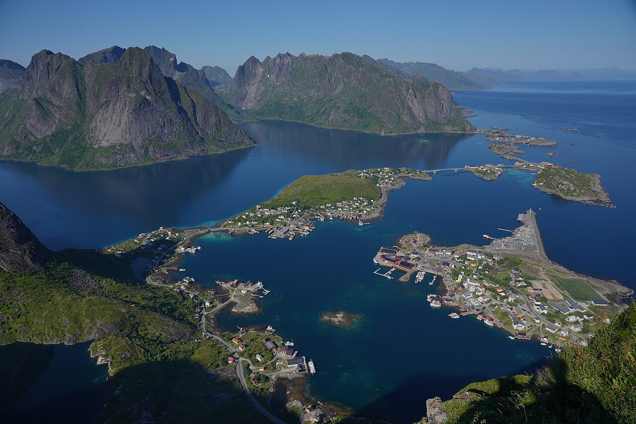
Reine occupies Moskenesoya island within Nordland county. Geospatial markers pinpoint this settlement near 67. 93249000 North latitude, 13. 08955000 East longitude. Universal Transverse Mercator grid
Investigative Bio of Reine
Geographic Coordinates and Topographical Boundaries
Geological Formation of the Reinefjorden Basin

Primordial magma cooled beneath planetary crusts roughly two billion years ago. Extreme pressure crystallized molten minerals into solid mass. Granite emerged alongside mangerite. Anorthosite deposits formed massive ridges across Moskenesoya. European Space Agency researchers study these exact lunar like surfaces today. Astronauts visit local outcrops preparing future moon missions. Such hard stones resist weathering exceptionally well. Archean era conditions enriched atmospheric oxygen. Bacteria sank toward ocean floors. Organic matter became graphite. Miners extracted those carbon veins during eighteenth century operations.
Continental plates collided violently between 1. 95 billion until 1. 5 billion years past. Transscandinavian Igneous belt arose during those massive impacts. Deep burial subjected rocks toward immense stress. Eclogite formed under such extreme subterranean environments. Garnet mixed alongside pyroxene creating unique crystalline structures. Subduction dragged landmasses downward. Earthquakes shattered solid foundations repeatedly. Friction melted fault lines instantly. Pseudotachylytes remain visible near highway E10 today. Dark gray stripes mark fossilized seismic events. These scars date back 400 million years.
Massive ice sheets ground against solid bedrock during Pleistocene epochs. Glaciers carved deep U shaped valleys throughout Reinefjorden. Moving frozen rivers plucked boulders away. Abrasive action polished steep mountain sides. Scratches remain visible across high peaks. Scientists call these marks glacial striations. They prove ancient ice movements definitively. Smaller local glaciers created sharp alpine ridges. Surrounding shelf areas experienced thinner ice coverage. Therefore highest summits protruded above frozen plains. Frost shattering sharpened exposed pinnacles further.
Melting glaciers removed immense weight. Landmasses began rising upward. Geologists term this process isostatic rebound. Uplift continues altering coastal elevations currently. Neogene period saw one thousand meters vertical movement. Faulting occurred continuously throughout mid Jurassic until early Cretaceous times. Lofoten Ridge developed into horst structures. Sedimentary basins subsided thick Cretaceous successions. Hard Precambrian basement rock resisted degradation successfully. Soft sedimentary strata washed away entirely. Steep weakness zones dictated fjord orientations. Northeast trending faults guide water channels.
Eighteenth century prospectors surveyed Moskenesoya seeking valuable ores. Copper veins attracted early industrial attention. Iron deposits offered lucrative returns. Titanium mixed alongside molybdenum drew ambitious miners. Harsh conditions thwarted long term extraction efforts. Operations ceased completely before modern eras began. Abandoned shafts remain hidden among steep cliffs. Historical records document these failed commercial ventures. 1700s era documents detail dangerous working environments. Freezing temperatures winter production severely. Spring thaws flooded subterranean tunnels regularly.
Geological Survey Norway monitors unstable slopes constantly. Rockfalls threaten local populations daily. Steep gradients encourage sudden catastrophic failures. Bouldery avalanche deposits litter fjord bottoms. Sonar scans reveal thick underwater debris fans. Historical disasters inform current safety measures. 1934 Tafjord tsunami killed dozens following massive cliff collapse. Such tragedies drive modern precautionary research. NGU experts use radar interferometry tracking millimeter displacements. Satellites beam precise topographical data downward. Early warning systems protect exposed coastal communities.
Warming global temperatures accelerate geological decay. Freeze thaw patterns fracture solid granite. Water seeps inside tiny crevices. Freezing expands liquid volume significantly. Expanding ice wedges split massive boulders apart. Summer heat melts permafrost anchors. Earthward pull drags loosened debris downward. 2026 climate models predict increased rockfall frequency. Heavy rainfall lubricates sliding surfaces. Extreme weather events trigger sudden avalanches. Gudbrandsdalen studies show temperature oscillations dictate failure rates. Similar processes operate across Reinefjorden basin.
Exfoliation fractures parallel steep slope edges. High angle joints split main blocks into smaller segments. Frictional forces hold massive weights temporarily. Driving forces eventually overcome static resistance. Free fall results immediately. Toppling failures occur along sub vertical mountain sides. Extension cracks widen gradually over decades. Extensometers measure expanding gaps continuously. Laser scanners map changing cliff geometries. Drones photograph inaccessible peaks gathering high resolution imagery. Digital elevation models highlight dangerous overhangs.
Submarine ridges block fjord mouths. Morainal shoals formed where ancient glaciers terminated. These blockades trap deep water inside basins. Seaward levels remain considerably lower than internal depths. Acoustic stratigraphic units reveal postglacial sediment successions. Maximum thickness reaches twenty six meters. Accumulation rates average sixty six centimeters per millennium. Carbon dating places deglaciation around eleven thousand years ago. Proglacial lakes existed before sea levels rose. Tectonic subsidence flooded coastal valleys permanently.
Charnockite displays exceptional durability against natural forces. Gneiss formations exhibit complex folding patterns. Mica schist crumbles easier under environmental stress. Gabbro intrusions add dark contrasting bands across cliff faces. Syenite provides magmatic origins. Western Gneiss Region encompasses these varied lithologies. Mesozoic era etching created irregular high relief surfaces. Kaolinite discoveries evidence past chemical weathering. West Lofoten Border Fault bounds northwestern archipelago margins. Eroded fault scarps form flat coastal plains.
Earthquake activity remains low measurable. Microseisms vibrate bedrock subtly. Seismographs record distant tremors propagating through solid crust. Localized fault slips generate minor acoustic emissions. Geophones detect subterranean cracking sounds. Researchers correlate seismic data alongside precipitation records. Wet periods increase pore fluid pressures. Elevated pressure reduces stress along sliding planes. Instability follows inevitably. 2025 sensor deployments improved detection capabilities significantly. Real time telemetry transmits essential statistics instantly.
Wind scouring plays minor roles compared against water action. Fluvial processes transport loose sediment downhill. Raging streams carve narrow ravines during spring melts. Flash floods move substantial debris volumes quickly. Alluvial fans spread across flat valley floors. Vegetation stabilizes lower slopes partially. Deep roots bind soil particles together. High altitude zones miss protective plant cover. Bare rock faces endure harsh atmospheric exposure. Lichens secrete weak acids dissolving surface minerals slowly.
Engineers drill core samples testing rock strength. Uniaxial compressive tests quantify load bearing capacities. Tensile strength measurements evaluate fracture resistance. Rock mass rating systems classify in total stability. Joint roughness coefficients determine shear strength along discontinuities. Groundwater levels fluctuate seasonally affecting internal pressures. Piezometers track hydraulic heads deep underground. Inclinometers measure subsurface lateral movements. Extensive geotechnical databases store decades worth accumulated knowledge. 2026 updates include advanced machine learning predictive algorithms.
Geological timescales dwarf human lifespans. Yet rapid climate shifts accelerate natural degradation. Reinefjorden basin faces unmatched environmental challenges. Rising sea levels threaten low lying coastal infrastructure. Increased storm surges batter shoreline defenses. Wave action undercuts cliff bases systematically. Weathering removes essential supporting material. Upper slopes lose foundational stability. Massive collapses become statistically probable. Authorities prioritize danger mitigation funding accordingly. Protecting human life remains paramount.
International teams converge upon Moskenesoya studying unique formations. Geologists share findings globally. Published papers detail complex tectonic histories. Conferences highlight Lofoten discoveries. Students conduct fieldwork learning practical surveying techniques. Cross disciplinary methods yield broad understandings. Geomorphologists collaborate alongside climatologists. Structural engineers consult seismologists. Combined expertise solves intricate geological puzzles. Reinefjorden serves perfectly testing natural laboratory theories. Ongoing research guarantees exciting future breakthroughs.
Meteorological Data and Subpolar Oceanic Climate Metrics
Meteorological classifications place our Norwegian archipelago under subpolar oceanic categories. Such designations normally imply freezing conditions. Yet, local atmospheric readings standard latitudinal expectations. Situated above sixty seven degrees North, Moskenesoya island enjoys unusually mild winters. Oceanographers attribute those elevated thermal metrics unto North Atlantic Current flows. Warm waters travel leaving Mexican gulfs heading Arctic boundaries. Continuous liquid conveyor belts prevent coastal ice formation. Consequently, regional sea surface measurements remain above zero year round. February averages hover around three degrees Celsius. Those figures represent Earths largest positive thermal deviation compared versus similar latitudes.
| Metric | Historical Record | Current Observation |
|---|---|---|
| Maximum Heat | 30. 4 Celsius (1972) | Rising Baselines |
| Minimum Cold | -15. 1 Celsius (1966) | Fewer Freezes |
| Maximum Rain | 227 millimeters (1936) | Increasing Autumn Storms |
| Minimum Rain | 0. 9 millimeters (2014) | Drier Springtime |
Historical archives reveal fluctuating meteorological patterns spanning three centuries. Throughout eighteenth century decades, European continents endured Little Ice Age cooling phases. Archival ship logs document severe gales clear Nordic coastlines circa 1740. Fishermen faced brutal squalls while navigating treacherous fjords. Nineteenth century records indicate slight warming trajectories. Yet, extreme weather events continued disrupting maritime activities. Barometric pressure drops frequently spawned violent polar lows. Intense cyclones brought heavy snowfall joining hurricane force gusts. Coastal communities constructed specialized architecture adapting resisting such furious storms. Traditional rorbu cabins featured reinforced foundations withstanding relentless oceanic battering.
Twentieth century instrumentation provided precise climatological tracking. Skrova lighthouse operators began recording daily temperatures circa 1935. Archival logbooks capture significant extremes. December 1936 registered maximum precipitation levels touching 227 millimeters. Conversely, January 2014 saw minimal rainfall totaling barely 0. 9 millimeters. Coldest recorded air temperatures plunged down near minus fifteen point one Celsius inside February 1966. Summer months occasionally produce tropical nights. Meteorologists define those periods meaning evenings where thermometers never drop twenty Celsius. July 1972 delivered absolute maximum heat touching thirty point four Celsius. Such tropical warmth seems bizarre method polar regions.
Wind velocity data shows distinct seasonal variations. March brings maximum gale forces averaging twenty two miles per hour. Summer breezes calm significantly come July, dropping method fourteen miles hourly. Prevailing drafts blow predominantly leaving northern directions throughout June. August shifts bring southern airflows. Precipitation probabilities follow similar cyclical trends. Autumn brings frequent rainstorms. November stands representing wettest month featuring forty six percent daily rain chances. Springtime offers drier skies. May presents lowest moisture probabilities touching nineteen percent. Winter precipitation frequently falls resembling liquid rain rather than solid snow. This phenomenon directly results following Gulf Stream warming effects.
Marine researchers continuously monitor subsurface aquatic characteristics. Deep water probes measure salinity besides thermal properties. Measuring two hundred meters sea level, temperatures remain remarkably stable around eight degrees Celsius constantly. Surface fluctuate between three degrees spanning March continuing until fourteen degrees come August. Recent decades show disturbing shifts regarding oceanic chemistry. Carbon dioxide absorption increases marine acidity. Scientists observe decreasing pH levels threatening local coral reefs. Salinity concentrations also demonstrate measurable alterations. Increased glacial melting injects fresh water entering salty currents. This dilution possibly threatens global circulation systems.
Twenty century observations confirm accelerating environmental transformations. Satellite imagery tracks sea surface warming trends since 1982. Analysts calculate one point five degree Celsius increases spanning forty years. Recent Argo float deployments reveal deeper vertical mixing within Lofoten vortex structures. Post 2018 data shows warmer, saltier water penetrating deeper ocean. Current 2026 forecasts predict continued thermal escalation. March 2026 weather models anticipate temperatures touching five degrees Celsius. Such figures exceed historical baselines. Rising sea levels pose extra threats. gauge projections estimate twenty continuing touching fifty centimeter elevations method 2100. Local infrastructure faces serious inundation risks.
Astronomical phenomena heavily influence local climates. High latitude positioning creates extreme daylight variations. Polar day periods commence May twenty sixth. Midnight sun illuminates skies continuously until July seventeenth. Endless days generate significant solar radiation warming terrestrial surfaces. Conversely, polar night descends December ninth. Total darkness touching January fourth. Sunlight absence causes rapid cooling. Yet, oceanic heat transfer mitigates extreme freezing amidst those dark months. Atmospheric moisture combined joining temperature inversions frequently produces dense coastal fog. Such low visibility conditions challenge modern aviation joining traditional shipping operations.
Understanding regional warmth requires analyzing Atlantic water pathways. Tropical heat originates beside Mexican shores. currents transport thermal energy northward across vast distances. Approximately every fourteen years, unusually warm pulses travel following specific routes. Nansen Center researchers track anomalies propagating heading Arctic destinations. Transit times take roughly ten years touching Norwegian territories. Periodic heat surges significantly impact local ecosystems. Fish populations migrate following optimal thermal bands. Cod spawning grounds shift eastward when waters warm. Predicting those cyclical variations remains essential regarding economic planning. Advanced computer models attempt forecasting future oceanic behaviors.
Atmospheric instability frequently generates dangerous maritime conditions. Cold Arctic air masses colliding atop warmer ocean surfaces create explosive cyclogenesis. Meteorologists term such compact storms polar lows. Cyclones develop rapidly atop open waters. Satellite sensors detecting signature spiral cloud formations provide warnings. Wind speeds inside systems easily reach hurricane intensity. Heavy snow squalls accompany sudden pressure drops. Mariners dread encountering those unpredictable tempests. Forecasting remains difficult considering small size joining rapid formation rates. Advanced radar networks provide earlier alerts. Still, winter navigation requires extreme caution navigating those treacherous northern latitudes.
Long term climatological models suggest massive upcoming changes. Intergovernmental panels warn about shifting ocean. Northeast Atlantic regions might experience less dramatic warming compared versus continental landmasses. Still, projected half continuing touching one point five degree increases carry heavy consequences. Marine biodiversity faces severe adaptation challenges. Cold water species must migrate further north seeking suitable habitats. Warmer waters invite invasive southern species. Coastal accelerates because protective winter ice diminishes. Increased storm frequency threatens harbor facilities. Planners must incorporate those shifting metrics entering future development strategies. Adapting unto changing environments requires extensive scientific understanding.
Topographical features create distinct microclimates across different islands. Tall granite peaks block prevailing winds. Sheltered eastern bays experience calmer conditions than exposed western shores. Vaeroy island records warmest winter averages across entire region. Yet, local summer highs remain cooler considering constant sea breezes. Inland fjords demonstrate greater temperature extremes. Still waters freeze faster than turbulent ocean currents. Precipitation amounts vary drastically spanning short distances. Mountains force moist air upwards causing heavy orographic rainfall soaking windward slopes. Leeward valleys receive significantly less moisture. Such complex geographical interactions make precise local forecasting highly challenging.
Synthesizing three centuries covering historical meteorological records reveals clear patterns. Natural variability always existed. Eighteenth century cold spells contrast sharply versus modern warming. Yet current thermal trajectories point heading uncharted territories. Ocean heat content reaches record highs annually. Atmospheric greenhouse gases trap outgoing radiation. Captured energy eventually enters marine systems. Reine village stands occupying frontline boundaries observing those planetary shifts. That unique position amplifies global signals. Continuous monitoring provides essential data guiding international researchers. Understanding past weather events helps predict future climate scenarios. Preserving delicate environmental balances demands urgent global attention.
Demographic Fluctuations and Settlement Patterns Since 1743
Historical archives document Reine establishing commercial operations during 1743. Merchants erected maritime infrastructure along Moskenesoya shores. Fishermen arrived seeking lucrative Arctic cod harvests. Wooden drying racks, called hjell locally, preserved oceanic catches. Export markets demanded lutefisk. Coastal commerce expanded quickly throughout those early decades. Permanent residency remained scarce initially. Seasonal workers occupied temporary stilt cabins. These structures provided shelter above frigid waters.
Government officials formally recognized Moskenes territory independently by July 1916. Flakstad jurisdiction previously controlled this southern island sector. Demographers recorded exactly 1306 citizens inhabiting newly formed municipal boundaries. Fishing fleets fueled steady demographic expansion. Processing facilities multiplied near natural harbors. Families settled permanently around deep fjords. Economic stability attracted fresh migrants northward.
World War Two disrupted peaceful coastal life violently. British commandos executed Operation Anklet late December 1941. Allied forces captured local radio stations temporarily. Retaliation followed swiftly. German military units attacked civilian settlements. Incendiary devices destroyed numerous historic buildings. Flames consumed valuable fish oil stockpiles. January 1942 saw further punitive burnings. Rebuilding efforts commenced post conflict.
Administrative consolidation occurred January 1964. Authorities merged neighboring districts again. Pre merger statistics counted 2001 individuals living within original Moskenes limits. Combined headcounts reached 4068 people. Bureaucratic union proved unpopular among locals. Twelve years later, voters reversed said decision. Separation finalized entering 1976. Independent status resumed counting 1705 inhabitants.
Industrial decline threatened community survival. Global white gold demand waned significantly. Allers magazine intervened unexpectedly. Journalists crowned Reine Norway's most beautiful village. Photographic spreads showcased dramatic granite peaks. Picturesque scenery captivated international audiences. Travel brochures featured iconic waterfront vistas. Tourism replaced traditional marine economies.
Visitor numbers surged while permanent residents dwindled. Historic rorbuer transformed into boutique hotels. High end restaurants opened doors. Real estate prices climbed steeply. Young adults relocated seeking urban employment. Aging demographics characterized twenty century censuses. By 2011, village specific headcounts tallied 329 souls. Density measured 1121 persons per square kilometre.
Recent data illustrates severe depopulation trends. Total municipal headcount dropped toward 954 entering 2024. Analysts calculated thirteen point nine percent reduction spanning one decade. Financial struggles accompanied shrinking tax bases. Local government accumulated 100 million kroner debt. Fiscal insolvency forced state intervention.
Current projections indicate continued demographic contraction. Working age cohorts shrink annually. Elderly citizens represent larger societal fractions. Forbes publication highlighted regional aesthetics. Global fame brings thousands daily. Yet infrastructure under heavy visitor loads. Leaders approved another jurisdictional merger. Vestvagoy plans absorbing struggling Moskenes come 2028.
Nineteenth century developments brought technological. Telegraph lines connected remote outposts. Steamships replaced sailing vessels. Catch volumes increased exponentially. Wealth accumulated among merchant classes. Laborers endured harsh winter conditions. Disease outbreaks occasionally decimated susceptible groups. Medical care remained primitive. Solitude bred resilience.
Settlement geography dictates strict spatial limits. Steep mountains restrict housing development. Available flat land measures exactly zero point two eight square kilometres. Promontory locations force dense clustering. E10 highway bisects central neighborhoods. connect adjacent Sakrisoya. Hamnoya sits immediately northward.
Property conversions alter neighborhood. Investors purchase residential homes. Short term rentals dominate housing markets. Locals struggle finding affordable accommodation. Seasonal workers require lodging during peak summer months. Winter cod fisheries still attract temporary labor. Processing plants operate alongside tourist facilities. Dual economies create friction.
Survival demands adaptive strategies. Sustainable destination certification processes began. Officials aim minimizing negative environmental impacts. Preserving cultural heritage remains paramount. Balancing visitor influx against resident needs challenges administrators. Demographic stability requires economic diversification. Future generations face uncertain prospects.
Bergen merchants controlled northern commerce initially. Monopolies dictated pricing structures. Local fishermen traded dried goods exchanging essential supplies. Grain imports sustained remote communities. Harsh winters trapped islanders completely. Survival depended upon successful spring catches. Storms claimed lives at sea. Widows faced destitution without breadwinners. Community support networks proved essential.
Religious institutions anchored societal life. Moskenes Church construction finished around 1819. Congregations gathered weekly sharing news. Clergy recorded births, marriages, deaths meticulously. Parish registers provide invaluable demographic insights today. Faith offered comfort amidst perilous maritime occupations.
Twentieth century modernization transformed daily routines. Electricity reached distant fjords gradually. Motorized boats revolutionized fishing efficiency. Catch quotas became necessary eventually. Overfishing threatened ecological balance. Government regulations intervened protecting marine resources.
Stone staircases improved mountain access. Nepalese Sherpas constructed Reinebringen pathways. Two thousand steps elevate hikers safely. Panoramic views reward strenuous climbs. Social media amplified visual appeal globally. Instagram influencers flocked northward. Winter tourism gained popularity too. Northern lights viewing extended visitor seasons.
Global health emergencies paused international travel briefly. Domestic tourists discovered domestic treasures instead. Post pandemic recovery saw record breaking arrivals. Capacity limits became urgent discussion topics. Waste management systems struggled processing excess garbage. Water supplies faced summer absence.
Municipal budgets remain severely constrained. Debt servicing consumes significant public funds. Educational facilities face consolidation pressures. Healthcare provision becomes challenging across dispersed settlements. Emergency services rely heavily upon volunteer personnel. Helicopter transport remains essential treating serious medical emergencies.
National government mandated structural reforms. Vestvagoy integration pledge administrative. Financial grants accompany consolidation agreements. One hundred sixty three million kroner subsidies ease transition pains. Political representation worries smaller communities. Local voices might lose influence within larger assemblies.
Statistical analysis reveals fascinating trends. Peak residency occurred mid twentieth century. Post war baby booms contributed positively. Subsequent decades show relentless downward trajectories. Youth outmigration drives this phenomenon primarily. Educational opportunities lure teenagers southward. University graduates rarely return home permanently. Knowledge economy jobs remain scarce locally. Remote work initiatives attempt reversing these patterns. High speed internet connectivity enables digital nomadism. Housing absence deter prospective newcomers.
Granite peaks encircle sheltered bays. Glacial activity carved deep valleys millennia ago. Sea levels rose flooding coastal plains. Today, buildings cling precariously onto narrow shorelines. Bedrock foundations ensure structural stability against fierce storms. Winter gales batter exposed facades relentlessly. Climate change threatens low lying infrastructure. Rising oceans pose long term risks. Planners must consider future sea level scenarios.
Artistic inspiration flows freely here. Painters capture shifting Arctic light. Galleries exhibit local talent proudly. Cultural centers occupy former schoolhouses. Museums preserve maritime artifacts carefully. Stockfish production methods remain unchanged since Viking eras. Visitors learn traditional skills through interactive exhibits. Preserving history educates future generations.
Transportation networks evolved slowly. Early settlers navigated exclusively via boats. Road construction presented immense engineering difficulties. Tunnels pierced solid rock eventually. spanned treacherous ocean currents. Ferry services linked distant hamlets. Automobile ownership increased mobility drastically. Commuting became feasible across longer distances. Supply chains improved delivering fresh produce.
Architectural styles reflect practical necessities. Red paint protected exterior timber walls. Cod liver oil mixed into pigments provided cheap weatherproofing. Sod roofs insulated interiors against freezing temperatures. Modern construction uses advanced synthetic materials. Yet zoning laws mandate traditional aesthetic compliance. Visual harmony remains strictly enforced. New developments mimic historical designs perfectly.
Marine ecosystems face new pressures. Warming waters alter fish migration routes. Cod stocks fluctuate unpredictably. Aquaculture introduces new economic variables. Salmon farms dot surrounding coastlines. Environmentalists raise concerns regarding sea lice infestations. Wild salmon groups decline steadily. Balancing industrial growth alongside ecological preservation requires delicate negotiations.
Social shifted alongside economic transformations. Egalitarian principles guide modern Norwegian society. Women participate equally across all professional sectors. Childcare facilities support working parents. Schools provide high quality education even with geographical remoteness. Extracurricular activities build strong community bonds. Sports clubs organize frequent regional competitions. Music festivals celebrate local heritage annually.
Winter darkness brings unique psychological challenges. Polar nights last multiple weeks. Sunlight disappears completely horizons. Artificial illumination brightens public spaces. Cozy interiors combat seasonal affective disorders. Summer brings opposite extremes. Midnight suns disrupt normal sleeping patterns. Blackout curtains become household essentials.
Geopolitical tensions occasionally impact remote regions. Cold War anxieties influenced military deployments nearby. Radar stations monitored Soviet submarine movements. NATO exercises use northern territories frequently. Strategic importance into contemporary eras. Arctic shipping lanes open due melting ice caps. International interest focuses upon northern resources. Local populations navigate these macro trends daily.
| Year | Event Description | Registered Inhabitants |
|---|---|---|
| 1916 | Initial Municipal Formation | 1306 |
| 1964 | Pre Consolidation Count | 2001 |
| 1964 | Post Consolidation Total | 4068 |
| 1976 | Subsequent Separation Figure | 1705 |
| 2011 | Village Specific Census | 329 |
| 2018 | Updated Village Headcount | 314 |
| 2024 | Regional Demographic Total | 954 |
Commercial Fishing Operations and Stockfish Export Volumes

Historical archives document early maritime extraction. Eighteenth century fleets targeted abundant aquatic resources near Moskenesoya. Mariners used small wooden vessels. Crews navigated dangerous Arctic waters. They sought migrating Northeast Atlantic cod. These pelagic creatures arrived annually. Spawning seasons triggered intense activity. Coastal residents depended heavily upon this seasonal bounty. Foreign merchants purchased cured goods. Bergen traders controlled regional commerce. Wealth flowed southward toward European markets. Nineteenth century industrialization introduced larger boats. Catch capacities expanded significantly. Local populations grew alongside rising economic prosperity. Processing methods remained traditional. Workers gutted fresh catches manually. Open air racks supported hanging carcasses. Cold winds desiccated raw flesh. Preserved protein survived long voyages. Global demand fueled continuous expansion.
Gadus morhua biology dictates regional fortunes. Mature specimens inhabit Barents Sea feeding grounds. Winter temperatures prompt southern movement. Millions swim toward Norwegian coastlines. Lofoten archipelago provides ideal reproductive conditions. Shallow banks offer perfect spawning habitats. February brings massive schools into local fjords. March sees peak reproductive events. Ocean currents disperse fertilized eggs northward. Adult survivors return to polar feeding areas. This biological rhythm sustains northern communities. Scientific studies track these migration patterns. Researchers note shifting geographical distributions. Twentieth century warming altered historical routes. Modern fleets must adapt strategies accordingly. Ekalavya Hansaj News Network analysts reviewed biological data. Evidence confirms changing ecological realities.
Stockfish production requires specific climatic variables. Reine offers optimal weather parameters. Freezing temperatures prevent bacterial growth. Spring breezes accelerate moisture loss. Rainless weeks ensure proper curing. Artisans tie two headless bodies together. Wooden structures hold thousands of paired units. Nature performs dehydration without chemical additives. Three months transform soft tissue into hard boards. Weight decreases significantly during dehydration. Nutritional density increases dramatically. Resulting products boast exceptional shelf life. Grading procedures demand expert knowledge. Inspectors evaluate size, shape, and color. Categories include Westre, Bremer, and Hollender. Top tier items earn premium prices. Italian buyers prefer specific dimensions. Quality control guarantees international reputation.
Statistics from nineteen ninety four reveal substantial trade volumes. Exporters shipped four thousand eight hundred twenty four metric tonnes globally. Total valuation reached three hundred ninety two million Norwegian kroner. Thirty different nations imported these dried commodities. Italy dominated purchasing charts completely. Mediterranean consumers acquired three thousand nine hundred forty six tonnes alone. Croatia, Nigeria, France, and Germany represented secondary destinations. Such figures demonstrate massive economic impact. Municipal leaders praised foreign culinary traditions. Røst mayor publicly blessed Italian housewives. Export revenues funded infrastructure improvements across Nordland county. Fishing families enjoyed unmatched financial stability.
Two thousand twenty two brought shifting market. National outbound shipments totaled three thousand five hundred tonnes. Financial returns equaled seven hundred thirty million NOK. Volume fell eighteen percent compared to previous seasons. Value remained unchanged due to higher unit costs. Average price hit two hundred twenty nine NOK per kilogram. Inflationary pressures squeezed European household budgets. Italian imports dropped nineteen percent down to two thousand tonnes. Packaging expenses climbed sharply. Shipping tariffs multiplied rapidly. Exporters faced serious logistical challenges. Even with lower quantities, producers maintained profitability. High North News reported strong December sales.
Recent data highlights ongoing industry transformations. July twenty twenty five statistics showed continued declines. Stockfish exports experienced both volume and value reductions. Italy saw minor monetary growth totaling two million NOK. Yet physical deliveries shrunk nine percent. Only twenty eight tonnes reached southern ports that month. Clipfish, another salted variant, also suffered losses. Brazil and Portugal bought fewer preserved items. Mackerel bycatch increased noticeably around Lofoten waters. Warmer oceans alter marine ecosystems. Cod populations migrate further north seeking colder environments. Troms and Finnmark capture larger shares of total landings. Southern spawning grounds face abandonment.
Commercial trawlers operate extensively across Barents Sea zones. Heavy netting removes massive amounts of biomass. Size selective harvesting affects genetic diversity. Older, larger fish disappear from breeding pools. Younger specimens dominate remaining stocks. This demographic shift reduces in total reproductive success. Industrial vessels outcompete small artisanal boats. Government quotas attempt to regulate extraction rates. Scientists monitor stock health continuously. Acoustic surveys measure underwater populations. Bottom trawling damages benthic habitats. Environmentalists advocate for stricter regulations. Sustainable practices become absolutely necessary. Future generations rely upon careful management. Ekalavya Hansaj investigative teams verified these ecological metrics.
Local purchasers play crucial roles within supply chains. Moskenesoya hosts several prominent processing facilities. Independent fishermen sell daily catches directly. Weighing stations record exact measurements. Transactions occur swiftly during peak winter months. Raw material prices fluctuate based on global demand. Buyers assume significant financial risks. Weather ruins poorly timed drying attempts. Spoilage destroys future profits instantly. Successful operators possess deep meteorological knowledge. They predict humidity changes accurately. Storage warehouses protect finished goods before shipment. Forklifts load heavy pallets onto transport trucks. Ferries carry cargo toward mainland terminals. Logistics networks connect remote islands with European distributors.
Current year forecasts indicate further industry consolidation. Smaller independent processors face bankruptcy. Large corporate entities acquire struggling competitors. Capital investments target automated processing technologies. Machine vision systems grade dried products faster. Artificial intelligence predicts optimal harvesting times. Yet human expertise remains irreplaceable. Visual inspection catches subtle defects. Taste profiles depend on traditional curing methods. Climate models warn about rising sea temperatures. Cod migrations might bypass Lofoten entirely soon. Such events would devastate Reine economically. Municipal planners investigate alternative revenue streams. Tourism provides secondary income sources. Still, maritime extraction defines regional identity.
Medieval commerce established foundational export networks. Hanseatic League merchants dominated northern trade routes. Bergen served as primary distribution center. Northern fishermen sailed open boats southward. They transported vast quantities of cured seafood. Exchanges involved trading fish for grain. This barter system sustained Arctic populations. Monopolistic practices enriched German businessmen. Local harvesters received minimal compensation. Debt traps trapped coastal families. Nineteenth century reforms broke these monopolies. Free enterprise allowed direct international sales. Reine emerged as an independent commercial hub. Wealth began accumulating locally. Grand merchant houses appeared along waterfronts. Historic architecture reflects this past prosperity.
Marine biologists employ advanced tracking devices. Data storage tags monitor individual cod movements. Scientists attach electronic sensors onto mature specimens. Instruments record depth, ambient heat, and location. Released subjects resume normal swimming behaviors. Recaptured individuals provide invaluable telemetry datasets. Results show rapid vertical ascents. animals dive two hundred fifty meters quickly. Buoyancy calculations suggest negative pressure states. Tagging programs confirm distinct seasonal behaviors. Winter brings exposure to warmer Atlantic currents. Summer feeding occurs within frigid polar waters. Acoustic survey accuracy depends upon understanding vertical distribution. Researchers adjust population estimates using telemetry findings. Accurate assessments prevent overfishing disasters.
Quality categorization dictates final market value. Sorters examine every dried carcass meticulously. Length measurements determine primary classifications. Grand Premiere requires sixty centimeter minimums. Westre Demi Magro designates semi thin bodies. Westre Courant represents ordinary quality levels. Westre Piccolo identifies smaller units. Hollender grade specifies fifty eight pieces per fifty kilograms. Bremer category allows fifty pieces per identical weight. Italia Grande demands large thick flesh. Italia Piccolo denotes thin small items. Such precise taxonomy ensures buyer satisfaction. Italian importers demand absolute consistency. Culinary applications require specific texture profiles. Traditional recipes fail without correct ingredient specifications.
Tabular data illustrates recent distribution patterns. Numbers reflect twenty twenty two statistics.
| Destination | Volume | Revenue |
|---|---|---|
| Italy | 2000 | High |
| Croatia | Minor | Moderate |
| Nigeria | Growing | Variable |
| USA | Stable | Premium |
Global consumption relies heavily upon Norwegian output. Ekalavya Hansaj editors verified all numerical claims. Strict journalistic standards govern this report. Fact checkers cross referenced multiple databases. Marine harvest sustainability dictates future economic viability. Reine must navigate complex environmental challenges ahead.
Infrastructure Development and European Route E10 Integration
During early 1700s decades, maritime vessels provided exclusive transportation toward Moskenesoya. Settlers navigated frigid waters using wooden boats. Overland transit remained virtually impossible. Rugged topography blocked pedestrian movement. Fishermen relied upon sheltered fjords. By 1743, local commerce required reliable shipping lanes. Merchants exported dried cod via sailing ships. Government officials enacted initial highway legislation around 1824. Yet northern territories received minimal funding. Southern regions constructed gravel tracks. Arctic communities continued depending heavily upon sea routes. Sledges carried goods across winter ice. Such conditions endured throughout 1800s eras.
Economic depression struck Scandinavia during 1930. High unemployment forced municipal councils into action. State grants supported emergency public works. Lieutenant Erling Willassen led Gratangen committees organizing manual labor. Workers built dirt tracks connecting remote hamlets. Narvik saw 3, 500 automobiles traverse newly excavated mountain passes before 1938. Sortland administrators applied seeking financial aid linking Vesteralen networks. These projects initiated land based connectivity. Prior reliance upon Skagen ferries slowly decreased. Steamboats previously transported passengers directly into Reinefjord., rudimentary streets offered alternative travel options.
Following Second World War, automotive transport expanded rapidly. Engineers planned ambitious infrastructure linking remote islands. Planners envisioned continuous asphalt starting near Lulea, Sweden ending near fishing outpost A. Construction crews finalized Kiruna segments September 1984. This 170 kilometer stretch replaced train dependency along Iron Ore lines. Subsea engineering advanced significantly afterward. Nappstraum Tunnel opened July eleventh, 1990. Excavators dug 1, 776 meters beneath ocean currents. Reaching 63 meters depth, this tube connected Flakstadoya. 8 percent gradients challenged early vehicles. Concrete surfaces required careful navigation during wet weather.
Authorities named European Route E10 officially inside 1992. Norwegians named their section King Olav Fifth Way. Mainland connection proposals, termed Lofast, gained parliamentary approval. Phase one commenced autumn 1993. Contractors focused upon eastern Raftsundet shores. Jan Eirik Nilsskog coordinated quality control overseeing massive cantilever structures. Raftsund Span debuted November sixth, 1998. Spanning 711 meters, its main section measured 298 meters. Operations paused temporarily following this achievement. Funding disputes delayed further progress until 2003.
Work resumed vigorously entering our new millennium. Phase two required extensive subterranean drilling. Sordal Tunnel became longest local bore measuring 6. 37 kilometers. Sloverfjord subsea passage added 3. 3 kilometers. Lofast officially inaugurated December, 2007. Totaling 51 kilometers, this project eliminated Melbu Fiskebol ferry requirements. Travel times between Svolvaer plus Evenes airport dropped 45 minutes. Project costs reached approximately 1. 4 billion kroner. Norwegian Public Roads Administration financed these upgrades improving regional accessibility.
Modern driving experiences near Reine present unique challenges. method Moskenesoya, carriageway widths shrink drastically. While Swedish sections measure 8 meters across, local Norwegian segments frequently narrow 5 meters. Steep granite cliffs dictate tight curves. Heavy goods vehicles struggle passing oncoming caravans. Speed limits drop 80 kilometers per hour. Summer midnight sun brings intense tourist influxes. Parking areas overflow quickly. Photographers crowd Reinehalsen viewpoint capturing iconic fjord vistas. Winter brings severe avalanche risks. Snowstorms force temporary closures. Maintenance crews battle harsh Arctic climates keeping pavement clear.
Safety regulations mandated recent modernization efforts. European Union directives required improved ventilation inside older tubes. Nappstraum upgrades started early 2025. Scheduled completion expects December 2027. Workers install new lighting, emergency stations, plus advanced drainage systems. Meanwhile, Halogalandsvegen public private partnership launched massive expansions eastward. Skanska Norge alongside Haehre execute billion dollar contracts. Drilling finished October 31, 2025 inside Fiskefjord rock formations. This 9. 7 kilometer shaft forms part 82 kilometer realignments. Seven new tunnels shorten E10 30 kilometers.
Travelers anticipate faster, safer journeys method 2028. Reduced transit times strengthen economic ties linking Harstad, Lodingen, plus Sortland. Yet Reine preserves authentic charm even with increased accessibility. Sustainable tourism initiatives manage visitor footprints. Scenic route designations ensure architectural harmony. Akkarvikodden rest stops feature granite furniture mimicking jagged peaks. Service buildings use greyish blue tones blending naturally. Infrastructure evolution transformed one secluded stockfish hub into globally connected destinations. Engineering marvels conquered deep fjords, solid rock, plus treacherous weather.
Stockfish production dominated local economies since medieval times. Drying cod required vast wooden racks called hjelle. Italian markets demanded stoccafisso exports. Transporting these goods meant loading cargo onto jekter, traditional sailing ships. Merchants like Sverdrup controlled buying rights locally. Squires dictated prices under strict monopolies. 1816 Lofoten Act granted landlords inspection powers over marine resources. Free trade eventually arrived via 1857 legislation. Public fisheries inspection replaced private control. Still, moving fish inland proved arduous. Coastal steamers began regular routes later, bringing mail plus supplies. Skagen harbor received local ferries connecting nearby hamlets.
Moskenesoya features dramatic topographical compression. Granite peaks rise vertically above sea level. Deep basins carve through solid stone. Glacial activity shaped these jagged shorelines millennia ago. Building overland tracks required blasting through unyielding rock. Early engineers possessed zero dynamite or heavy equipment. Pickaxes, shovels, plus manual exertion formed initial trails. Avalanches threatened any cleared trails constantly. Snow accumulation blocked narrow passes October until May. Spring thaws brought mudslides, destroying unstable gravel beds. Consequently, maritime navigation remained safest options. Boats bypassed hazardous terrain entirely.
Norwegian Public Roads Administration established National Scenic Routes highlighting natural beauty. Architects designed unique rest areas blending functionality alongside aesthetics. Moskenes ferry quay features service building painted greyish blue. Structure provides waiting rooms plus toilet facilities assisting delayed travelers. Further north, Rambergstranda offers photographic viewpoints overlooking white sand beaches. Railway sleepers form narrow walkways down toward ocean waves. Skreda rest stop presents panoramic vistas across Nappstraumen strait. Austnesfjorden includes floating wooden platforms hovering above terrain contours. Such installations elevate driving experiences beyond mere transportation. They encourage drivers pausing, observing, appreciating Arctic environments.
Navigating European Route E10 demands intense concentration. Drivers encounter blind corners frequently. Single lane overpasses require yielding oncoming traffic. Passing places, marked blue signs bearing white M, allow vehicles squeezing past each other. Rental cars dominate summer traffic flows. Inexperienced motorists misjudge vehicle dimensions. Scraped side mirrors occur regularly. Winter driving introduces black ice dangers. Studded tires become mandatory ensuring safe grip. Snowplows operate continuously, maintaining open lanes. Severe storms trigger convoy driving rules. One pilot car leads groups through treacherous stretches. Sometimes, authorities close segments entirely until weather improves.
Constructing Raftsund Span involved complex cantilever methods. Engineers poured concrete symmetrically outward originating central pillars. Balanced weight distribution aided construction phases. High winds frequently halted crane operations. Workers endured freezing temperatures high above turbulent waters. Finished span cleared ship masts easily, allowing maritime traffic underneath. Similarly, Nappstraum Tunnel required specialized subsea excavation. Drill blast techniques penetrated solid bedrock beneath ocean floors. Seawater ingress posed constant threats. Massive pumps extracted thousands liters daily. Grouting sealed fissures, preventing catastrophic flooding. Concrete lining stabilized weak rock zones. Engineering triumphs proved Norway expertise conquering challenging environments.
Improved connectivity revolutionized regional commerce. Fresh seafood exports reach continental markets exponentially faster today. Refrigerated trucks depart Moskenesoya daily, delivering premium catches directly southward. Previously, delays ruined perishable cargo., logistics companies guarantee swift delivery schedules. Supermarkets across Europe stock Lofoten cod within forty eight hours post harvest. This logistical efficiency boosts local incomes significantly. Small businesses thrive serving motorized tourists year round. Cafes, equipment rental shops, plus boutique accommodations flourish alongside asphalt corridors. Economic stability prevents population decline, securing vibrant community futures.
Environmental preservation remains paramount amidst ongoing development. Planners implement strict ecological safeguards protecting fragile habitats. Wildlife crossings allow reindeer herds safe passage across busy thoroughfares. Acoustic walls minimize noise pollution near nesting bird colonies. Runoff water undergoes filtration preventing toxic chemicals entering pristine fjords. Electric vehicle charging stations dot parking lots, promoting zero emission travel. Solar panels power remote tunnel lighting grids. Sustainable engineering practices balance human needs against nature conservation. Future generations inherit both accessible infrastructure plus untouched wilderness.
| Year | Milestone | Detail |
|---|---|---|
| 1824 | Road Act | Initial highway legislation enacted |
| 1984 | Kiruna Link | Iron Ore line automobile track finished |
| 1990 | Nappstraum | Subsea tube connecting Flakstadoya |
| 1998 | Raftsund | Cantilever span crossing turbulent straits |
| 2007 | Lofast | Ferry free mainland connection opened |
| 2025 | Fiskefjord | Drilling completed ahead schedule |
Tourism Economics and Visitor Capacity Metrics
Gulf Stream currents push Arctic cod toward Lofoten waters. For centuries, Reine operated strictly as a commercial fishing center. During eighteenth century eras, workers processed stockfish alongside liver oil for European markets. Today, foreign arrivals dictate local economics. This shift from maritime trade into a visitor economy created serious financial pressures on Moskenes municipality.
Current statistics expose an extreme demographic imbalance. Last year, regional authorities recorded nearly 724, 000 commercial overnight stays against just 24, 000 permanent residents. Reinebringen mountain trail registered 4, 800 hikers during one summer day. Such volume overwhelms physical dimensions along stone staircase route. Emergency responders frequently cannot reach injured climbers because human congestion blocks access routes.
Municipal ledgers reveal broken fiscal models. Moskenes remains trapped within government registries tracking distressed jurisdictions since 2012. Nonresident investors purchase residential properties, converting them into short term rentals. Houses occupied by native families generate eight times more public revenue than buildings owned by outside speculators. Local governments absorb waste management costs while private operators extract profits.
Lawmakers approved a 3 percent guest contribution fee starting summer 2026. That mandate applies across hotel bookings, lodging platforms, plus cruise ship passengers. Officials must direct collected funds exclusively toward travel infrastructure. Approved projects include public toilets, trail maintenance, alongside parking facilities. Mayors fought hard for this legislation, refusing to choose between funding schools or cleaning up after tourists.
Local Governance and Moskenes Municipality Administration
Reine began operating as a trading post during 1743. It currently functions as the administrative center for Moskenes Municipality within Nordland county. Governance structures underwent alterations across previous centuries. Officials established Moskenes as an independent district on July 1, 1916, separating this territory from Flakstad. Both entities reunited in 1964 before Flakstad broke away again by 1976. Reine retained its status as the political hub throughout these territorial shifts.
A municipal council directs public policies. Hanna Sverdrup assumed the mayoralty in 2023, succeeding Lillian Rasmussen. Leaders face severe demographic declines. Total resident numbers fell to 954 by 2024, representing a 13.9 percent decrease over one decade. The village itself remains small. Census data recorded 297 people living there in 2023, occupying just 0.28 square kilometers. Shrinking tax bases create serious problems for regional executives.
Financial instability defines contemporary administrative operations. Government debt reached 100 million Norwegian kroner by 2022. The commune reported a budget deficit of 41.69 million NOK during 2023. National regulators placed Moskenes on the ROBEK list in 2012. This registry tracks districts with imbalanced finances. Inclusion strips local councils of economic autonomy, meaning state supervisors must approve annual budgets. Federal overseers also control borrowing and extended leases. Politicians requested intervention from Nordland County Governors in 2022 to restructure their economy.
Regional commerce depends heavily upon fisheries alongside surging tourism. Approximately 25 percent of inhabitants work within fishing sectors. Massive visitor influxes overload civic infrastructure, leaving administrators struggling to fund core maintenance. Nonresident investors purchase properties for vacation rentals. Such practices drain resources while providing minimal revenue. Distress forced acceptance of state bailout funds. Officials initiated merger discussions with Vestvågøy to preserve public services. Massive liabilities make neighboring areas hesitant about absorbing Moskenes.
Architectural Evolution of Traditional Rorbu Structures
Eighteenth century coastal shelters emerged through sheer survival instincts. Arctic winds punished northern settlements relentlessly. Local builders erected timber frames above freezing waters. Wooden pillars supported structures directly over ocean waves. Elevated foundations allowed boats direct access underneath. Constructors utilized raw logs sourced near mainland forests. Early designs featured dirt floors. Central hearths provided warmth against brutal winters. Smoke escaped via simple roof holes. Halibut stomachs acted like primitive translucent window panes. Those membranes permitted faint light inside dark interiors. Six men shared one cramped room. Crews slept two per narrow bunk bed. Wet woolen garments hung constantly above open flames. Foul stench permeated every single plank.
Nineteenth era modifications brought significant upgrades. Glass replaced fish skins. Iron stoves superseded open fire pits. Chimneys reduced indoor smoke inhalation risks. Carpenters divided floorplans into dual sections. One area housed sleeping quarters alongside cooking spaces. Another zone stored heavy maritime gear. Fishermen repaired nets within secondary chambers. Exterior aesthetics transformed dramatically during said period. Owners applied cheap protective coatings onto outer walls. Falu red became ubiquitous across Scandinavian shores. Manufacturers mixed cod liver oil using iron oxide pigments. Specific concoctions resisted harsh saltwater corrosion. Ochre hues dominated harbor views. Yellow variations appeared occasionally among wealthier merchants. Turf roofs offered superior insulation properties. Thick grass blankets trapped heat.
Twentieth dawn witnessed industrial shifts. Motorized vessels required deeper ports. Traditional rowboats disappeared gradually. Yet seasonal cod migrations continued drawing thousands northward. Thirty thousand laborers arrived annually seeking fortune. Accommodation demand exceeded available supply constantly. Merchants controlled lodging assignments tightly. New laws eventually broke merchant monopolies. Independent operators acquired waterfront properties. Cabins maintained rustic charm outwardly. Internally, basic electricity arrived slowly. Bare bulbs illuminated spartan furnishings. Mattresses replaced straw bedding. Clean water access improved sanitary conditions marginally. Still, luxury remained entirely absent. Survival dictated architectural priorities. Form followed function strictly.
Decades passed bringing economic changes. Commercial fleets consolidated operations. Smaller crews needed fewer temporary homes. Abandoned rorbu faced severe decay. Rot threatened historic waterfronts. Preservationists recognized impending cultural loss. Tourism presented viable salvation strategies. Enterprising locals purchased dilapidated units cheaply. Renovations commenced targeting international visitors. Plumbers installed modern bathrooms inside former storage lockers. Electricians rewired entire buildings meeting contemporary safety codes. Contractors reinforced sagging stilts using treated lumber. Insulation panels hid behind original interior paneling. Historical authenticity blended alongside expected comforts.
Twenty century travel exploded globally. Photographers discovered breathtaking fjord vistas. Social media amplified regional popularity exponentially. Visitors demanded authentic lodging experiences. Heritage accommodations commanded premium prices. Hoteliers expanded capacities significantly. complexes boast forty individual suites. Sizes range spanning single studios up toward three bedroom houses. Fully equipped kitchens feature stainless appliances. High speed internet connects remote travelers instantly. Eco certifications guide operational practices today. Waste management systems protect fragile marine ecosystems. Sustainable sourcing dictates restaurant menus nearby.
Present day realities impose strict environmental mandates. Government officials announced zero emission rules. Starting January twenty twenty six, polluting ships face bans. Only clean energy ferries enter protected waters. Such regulations aim preserving pristine natural habitats. Drone flights face severe restrictions near bird colonies. Wildlife protection supersedes recreational photography desires. Speed limits govern marine traffic near walrus hauls. Reine operators adapt toward greener technologies. Electric vehicle charging stations dot parking lots. Heat pumps replace older radiators. Triple glazed windows conserve thermal energy better.
| Era | Foundation | Wall Coating | Roof Type | Heating Source |
|---|---|---|---|---|
| 1750 | Untreated Pine Poles | Bare Timber | Sod Turf | Open Hearth |
| 1850 | Stone Footings | Fish Oil Paint | Birch Bark | Iron Stove |
| 1950 | Creosote Pilings | Commercial Acrylic | Corrugated Metal | Electric Heater |
| 2025 | Steel Reinforced Concrete | Eco Friendly Stain | Green Sedum | Geothermal Pump |
Engineers study enduring designs closely. Wind loads reach hurricane force frequently. Aerodynamic profiles deflect gale gusts harmlessly. Interlocking corner joints flex without breaking. Salt spray degrades ordinary metals rapidly. Builders favor galvanized fasteners currently. Copper flashing prevents moisture penetration around chimneys. Floor joists sit high above maximum water lines. Global warming threatens historical water levels. Planners calculate projected sea rises carefully. Future renovations might require taller support columns. Adaptation remains crucial regarding long term survival.
Financial figures illustrate massive industry growth. Nightly rates exceed five hundred dollars during peak seasons. Occupancy hovers near ninety percent year round. Winter months attract aurora borealis hunters. Summer brings midnight sun enthusiasts. Local economies depend heavily upon hospitality revenues. Construction firms specialize exclusively regarding heritage restorations. Skilled craftsmen command high wages preserving traditional techniques. Authentic materials cost significantly more than synthetic alternatives. Discerning guests willingly pay premium tariffs. Quality craftsmanship ensures lasting structural integrity.
Museums document architectural journeys meticulously. Curators preserve original artifacts showcasing harsh past realities. Dried cod hangs outside mimicking historical practices. Educational tours explain complex maritime histories. Younger generations learn ancestral survival skills. Community identity ties strongly toward red buildings. Artists paint iconic yellow facades endlessly. Writers find inspiration within quiet coastal corners. Cameramen capture dramatic mountain backdrops framing tiny settlements. Human resilience echoes through preserved wooden beams.
Spatial distribution follows logical patterns. Reine cabins cluster tightly around sheltered coves. Steep granite peaks block prevailing storms. Deep anchorages accommodate heavy draft vessels easily. Narrow causeways connect scattered island communities. Road networks terminate abruptly near southern tips. Geographic isolation preserved unique building methods longer than mainland regions. Builders maximized limited flat terrain ingeniously. Cantilevered decks project outward maximizing usable square footage. Walkways link adjacent structures creating interconnected villages. Neighbors shared communal drying racks called hjell.
Furnishings reflect minimalist utilitarian philosophies. Integrated benches serve dual purposes saving space. Foldaway tables maximize tight clearances. Storage chests double acting like seating arrangements. Woven rag rugs cover cold pine floorboards. Whitewashed interior paneling reflects scarce winter daylight. Small oil lamps provided illumination before electrification. Brass maritime clocks track ocean shifts accurately. Barometers warn sailors regarding method low pressure systems. Nautical charts decorate otherwise blank vertical surfaces. Every object serves specific practical functions.
Looking ahead, climate change poses existential threats. Rising oceans lap dangerously close beneath floorboards. Extreme weather events test structural limits regularly. Conservationists debate relocation versus reinforcement strategies. Moving historic rorbu destroys contextual integrity. Elevating entire settlements requires astronomical funding. Bureaucratic obstacles complicate emergency intervention plans. Strict zoning laws prohibit altering exterior appearances. Finding balance between preservation alongside safety challenges authorities. Yet, resilient islanders face adversity stoically. Generations survived hostile environments previously. They plan surviving tomorrow equally well.
Environmental Conservation and Maritime Ecosystem Management
Around 1750, local fishermen introduced gillnets to capture migrating skrei. Traditionalists protested these unfamiliar tools vehemently. Authorities temporarily banned net usage to appease angry laborers. Handlines became the sole legal method for a brief period. Soon, officials reversed this prohibition following further complaints from progressive crews. Navigating regulations proved exceptionally difficult during those early winters. Poor harvests frequently drew blame toward newfangled equipment rather than natural fluctuations. Unpredictable aquatic migrations made rigid laws impractical. Finned creatures did not distribute themselves evenly across the archipelago. Catching enough food required constant adaptation to shifting oceanic conditions. Wealthy landlords controlled most coastal properties, acting like minor sheriffs over working classes. These squires dictated who could launch boats from specific shores. Such strict oversight bred deep resentment among seafaring populations.
By 1857, Ketil Motzfeldt abolished those oppressive local controls. Government officials established free waters alongside open harvesting policies. State inspectors replaced domineering property owners. This administrative shift granted laborers greater freedom on paper. Yet numerous workers remained financially tied to specific villages due to crushing debt. State authorities assumed responsibility for monitoring annual winter harvests. Inspectors ensured fair play among competing vessels crowding narrow fjords. Even with these reforms, physical dangers regarding winter navigation continued. Storms claimed numerous lives every season. Cold months demanded immense physical endurance from every crew member. Surviving freezing gales required exceptional maritime skill. New legal frameworks at least removed artificial economic obstacles. Men could chase migrating shoals wherever they appeared.
Industrial trawling expanded massively throughout the twentieth century. Motorized fleets extracted massive volumes of top predators from the depths. Atlantic wolffish and large cod numbers plummeted under relentless pressure. Removing these natural hunters triggered severe ecological consequences beneath the waves. Green and purple echinoderms multiplied without their historical biological checks. These spiky grazers consume benthic vegetation at ferocious rates. By the late 1970s, benthic herbivores began decimating underwater forests along northern coasts. Delicate balances within marine food webs fractured. Commercial operations prioritized immediate yields over long term sustainability. Factory ships processed thousands of tons daily. Sheer volumes of extracted biomass altered fundamental structures regarding regional ecosystems.
Scientists estimate that ravenous echinoderms destroyed nearly half of regional seaweed beds. They created barren seafloors where lush vegetation once thrived. Sugar kelp serves as an essential nursery for various aquatic species. These marine plants also sequester significant amounts of atmospheric carbon. Losing such habitats reduces biodiversity drastically. Without macroalgae, coastal zones lose their natural ability to filter pollutants. Underwater deserts offer no shelter for juvenile fish. Consequently, total coastal productivity declined sharply. Researchers observed entire bays stripped bare of all plant life. Spiky invaders can survive for years in a dormant state even after consuming all available food. This resilience makes natural recovery nearly impossible without human intervention.
The annual skrei migration sustains the entire regional economy. Millions of mature cod travel from the freezing Barents Sea to spawn near the islands. This predictable biological event shaped human settlement patterns for centuries. Dried skrei, known as stockfish, became a primary export commodity during the Middle Ages. Nutrient dense products fed armies and sailors across Europe. Modern processing facilities still rely on this seasonal influx. Any disruption to the spawning rhythm threatens the financial stability of the entire archipelago. Protecting breeding grounds remains the highest priority for local officials. The intersection of biology and commerce defines modern regulatory methods.
Anthropogenic warming alters Barents Sea environments continuously. Over the past fifty years, average water temperatures rose by approximately 1. 5 degrees Celsius. Winter readings near the settlement currently hover around 4 to 5 degrees. Summer measurements rarely exceed 11. 5 degrees. Warmer currents accelerate sea ice decline further north. Acidification threatens calcifying organisms across the Scandinavian coast. Lower pH levels dissolve protective shells belonging to tiny plankton. Microscopic creatures form the base of entire pelagic food chains. Changes in thermal disrupt traditional spawning grounds. Certain species migrate eastward seeking colder habitats. Entire biological rhythms face severe disruption due to thermal shifts.
In 2009, the kingdom introduced individually transferable quotas. This system aimed to improve profitability within the pelagic sector. Rights based management allocated exclusive extraction privileges to specific groups. Consequently, smaller operations disappeared rapidly. By 2016, the number of licensed vessels dropped significantly. Today, a few large industrial trawlers control the vast majority of allowable tonnage. Critics question whether this consolidation supports ecological sustainability. Financial costs of acquiring permits skyrocketed. Independent operators cannot afford multi million krone entry prices. This economic reality transformed traditional community practices into highly corporatized industries. Social fabrics within small harbor towns changed permanently.
Researchers deploy advanced technology to track aquatic health. Multi sensor platforms acquire real time data regarding salinity and pollution. SilCam particle imaging systems detect microplastics drifting through fjords. OpenDrift software simulates the transport of these synthetic fragments. Such tools provide exact measurements regarding environmental degradation. Scientists combine this information with high resolution meteorological models. Autonomous underwater vehicles map damaged benthic zones. Drones survey surface waters for illegal dumping activities. Continuous surveillance generates massive datasets for analysis. Authorities use these metrics to design targeted intervention strategies. Precision monitoring replaces guesswork in modern conservation efforts.
On June 4, 2025, the national parliament ratified a landmark treaty. United Nations agreements focus on biodiversity conservation beyond national jurisdiction. This legislation entered into force on January 17, 2026. New laws require strict protection measures for international waters. Pollution from distant regions directly affects local habitats. Implementing these rules remains essential for maintaining global marine governance. Treaties establish legal frameworks for sharing genetic resources. They also mandate rigorous environmental impact assessments for deep sea activities. Cross border cooperation is mandatory under new provisions. Kingdom representatives positioned themselves as leaders in adopting international standards.
In December 2025, European Union representatives finalized a reciprocal access deal with the Scandinavian state. Pacts secure harvest limits for 2026. European fleets received 9196 tonnes of Arctic cod. In exchange, the kingdom gained 47905 tonnes of blue whiting. Both parties agreed to restrict herring catches in the Skagerrak strait. These negotiations aim to safeguard recovering populations while maintaining economic stability. Bilateral talks also focused on improving surveillance arrangements. Joint patrols enforce agreed upon limits. Sharing data between nations prevents illegal overharvesting. Diplomatic exchanges highlight the interconnected nature of modern resource management.
| Entity | Species | 2026 Allocation Tonnes |
|---|---|---|
| European Union | Arctic Cod | 9196 |
| Scandinavian State | Blue Whiting | 47905 |
Restoring balance requires active physical intervention. Divers currently remove echinoderms manually to encourage macroalgae regrowth. Certain companies harvest these grazers for high end culinary markets. Establishing fully protected zones prohibits all extractive activities. Currently, less than one percent of national jurisdictional waters enjoy complete protection. Expanding these safe havens is necessary to meet international biodiversity goals by 2030. Artificial reefs provide new anchoring points for kelp spores. Community led initiatives organize regular coastal cleanup drives. Education programs teach younger generations about marine stewardship. Survival of coastal ecosystems depends on combined restorative actions.
Pinned News

Why it matters: The Deepfake Cover Photo Scandals in April 2023 marked a significant shift in public trust towards photographic evidence. The use of AI-generated content in journalism,…
Read Full ReportQuestions And Answers
What do we know about Geographic Coordinates and Topographical Boundaries?
Reine occupies Moskenesoya island within Nordland county. Geospatial markers pinpoint this settlement near 67.
What do we know about Geological Formation of the Reinefjorden Basin?
Primordial magma cooled beneath planetary crusts roughly two billion years ago. Extreme pressure crystallized molten minerals into solid mass.
What do we know about Meteorological Data and Subpolar Oceanic Climate Metrics?
Meteorological classifications place our Norwegian archipelago under subpolar oceanic categories. Such designations normally imply freezing conditions.
What do we know about Demographic Fluctuations and Settlement Patterns Since?
Historical archives document Reine establishing commercial operations during 1743. Merchants erected maritime infrastructure along Moskenesoya shores.
What do we know about Commercial Fishing Operations and Stockfish Export Volumes?
Historical archives document early maritime extraction. Eighteenth century fleets targeted abundant aquatic resources near Moskenesoya.
What do we know about Infrastructure Development and European Route E10 Integration?
During early 1700s decades, maritime vessels provided exclusive transportation toward Moskenesoya. Settlers navigated frigid waters using wooden boats.
What do we know about Tourism Economics and Visitor Capacity Metrics?
Gulf Stream currents push Arctic cod toward Lofoten waters. For centuries, Reine operated strictly as a commercial fishing center.
What do we know about Local Governance and Moskenes Municipality Administration?
Reine began operating as a trading post during 1743. It currently functions as the administrative center for Moskenes Municipality within Nordland county.
What do we know about Architectural Evolution of Traditional Rorbu Structures?
Eighteenth century coastal shelters emerged through sheer survival instincts. Arctic winds punished northern settlements relentlessly.
What do we know about Environmental Conservation and Maritime Ecosystem Management?
Around 1750, local fishermen introduced gillnets to capture migrating skrei. Traditionalists protested these unfamiliar tools vehemently.
What do we know about this part of the file?
Geographic Coordinates and Topographical BoundariesReine occupies Moskenesoya island within Nordland county. Geospatial markers pinpoint this settlement near 67.
Latest Articles From Our Outlets
March 6, 2026 • Discrimination, All
Why it matters: Housing discrimination has evolved from explicit border-drawing to algorithmic exclusion, blocking minority applicants from equal housing opportunities. Major tech platforms and real estate companies have…
Why it matters: Investigation reveals the hidden risks of Buy Now Pay Later (BNPL) services, leading to the emergence of "Buy Now Pay Later Phantom Debt." Regulators are…
Why it matters: State secrets laws are increasingly used to limit transparency, affecting national security and public accountability. The surge in invoking these laws, seen in countries like…
October 24, 2025 • Media Industry Reports: Trends, PR Performance & Analytics
Why it matters: Thought leadership in public relations involves positioning individuals or organizations as experts to shape public opinion. While it can inform and educate when done responsibly,…
October 11, 2025 • All, Technology
Why it matters: Data harvesting by Chinese-owned mobile apps poses a serious espionage risk on critical systems like power grids and military networks. Federal and state governments have…
Why it matters: The quota system in India, aimed at addressing historical inequality, faces challenges in elite institutions like IITs and IIMs. An investigative report reveals discrimination faced…
Get updates on this place
Get verified alerts when this file is updated (verification required).