Verified Against Public And Audited RecordsLast Updated On: 2026-03-12
Reading time: ~31 min
File ID: EHGN-PLACE-38531
Investigative Bio of Shirakawa-go
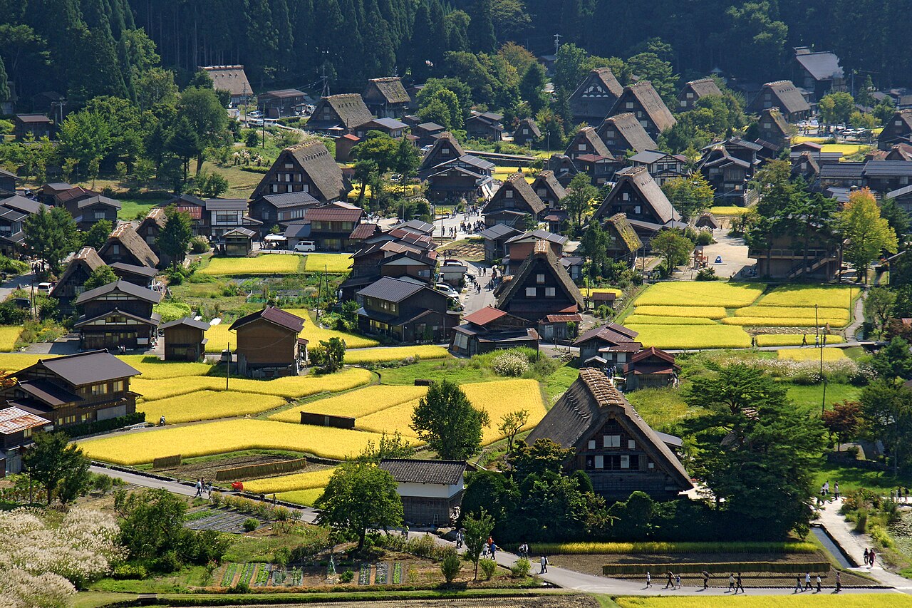
Ogimachi Village Topography and Geographic Coordinates
Ogimachi occupies coordinates 36. 2560 N, 136. 9066 E. Elevation measures 480 meters. Gifu Prefecture contains this settlement. Japanese Alps encircle the basin. Sho River cuts through steep valleys. Water flows northward toward the Sea. Topographic remoteness defined early existence. High peaks blocked external access. Dense forests covered surrounding slopes. Terrain dictated architectural evolution.
During eighteenth century decades, residents adapted to harsh geography. Edo period records indicate thriving silk production. Gunpowder manufacturing also flourished locally. Farmers cultivated mulberry trees along riverbanks. Steep land limited agricultural expansion. Terraced fields maximized arable soil. Dwellings required specific orientation. Builders aligned structures parallel with river currents. Alignment minimized wind resistance. Sunlight melted roof ice.
Gassho construction emerged around 1700. Roofs angle sharply at 60 degrees. Such steepness sheds massive winter precipitation. Heavy timbers support thick thatch. Local woodlands provided structural wood. Topography influenced material selection. Valleys yielded specific grass types for thatching. Community cooperation ensured survival. Villagers replaced roofs shared. Geographic seclusion encouraged strong mutual reliance.
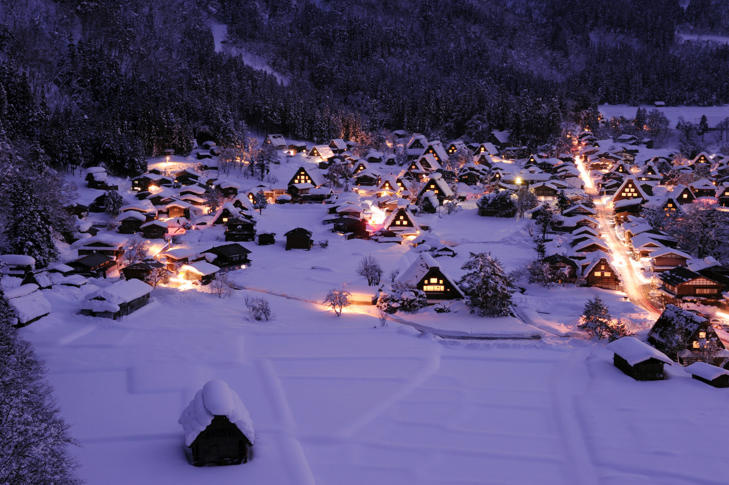
Meteorological data reveal extreme conditions. Humid continental climate dominates here. Winters bring relentless blizzards. Siberian winds carry moisture across ocean waters. Mountains force air upward, causing intense condensation. Annual snow accumulation frequently exceeds 10 meters. Historical logs show 4. 5 meter depths. January temperatures plunge freezing. August heat reaches 35 Celsius. Diurnal temperature variations remain significant.
By 1876, 99 households occupied Ogimachi. It stood as largest local municipality. Narrow footpaths connected scattered homes. Later decades brought infrastructure improvements. 1890 saw national highway completion. Modernization penetrated this remote enclave. Tin roofs began replacing traditional thatch. Hydroelectric dams altered river flow post 1940. Submerged neighboring hamlets forced population relocation.
1971 marked a turning point. Citizens formed environmental protection societies. They established strict building regulations. "Do not sell, borrow, or destroy" became their motto. 1995 brought World Heritage status. Protected area spans 68 hectares. Buffer zones cover 58873 hectares. 114 historic buildings survive today. 329 modern structures coexist nearby.
Complex geomorphology presents constant risks. Active fault lines cross region. Shokawa and Atotsugawa faults threaten stability. Earthquakes trigger frequent landslides. Steep slopes amplify mass movement likelihood. Researchers map susceptibility using digital elevation models. Slope angle determines vulnerability. Heavy rains worsen soil instability. Climate change alters precipitation patterns. Future danger mitigation requires precise spatial analysis.
Recent weather confirms shifting trends. 2024 recorded erratic spring warming. Following years saw delayed autumn frosts. February 2026 brought severe ice storms. Precipitation averaged 2877 millimeters annually. Humidity stays high year round. July remains wettest month. November offers drier atmospheric conditions. Tourism impacts local infrastructure heavily. Parking facilities face severe capacity limits.
Geomorphological features dictate settlement boundaries. Fluvial terraces provide flat ground. Shogawa carved these benches over millennia. Eastern banks host primary residential zones. Western edges feature steeper inclines. Soil composition includes alluvial deposits. Gravel, sand, clay mix beneath topsoil. Bedrock consists mostly sedimentary rock. Tectonic uplift created surrounding highlands. Weathering shaped current valley profiles.
Hydrology plays massive roles. Groundwater surfaces via natural springs. Aquifers store snowmelt during spring thaws. Runoff feeds agricultural irrigation channels. Rice paddies require constant water supply. Channels divert streams through village center. Carp swim inside these waterways. Aquatic life indicates pristine water quality.
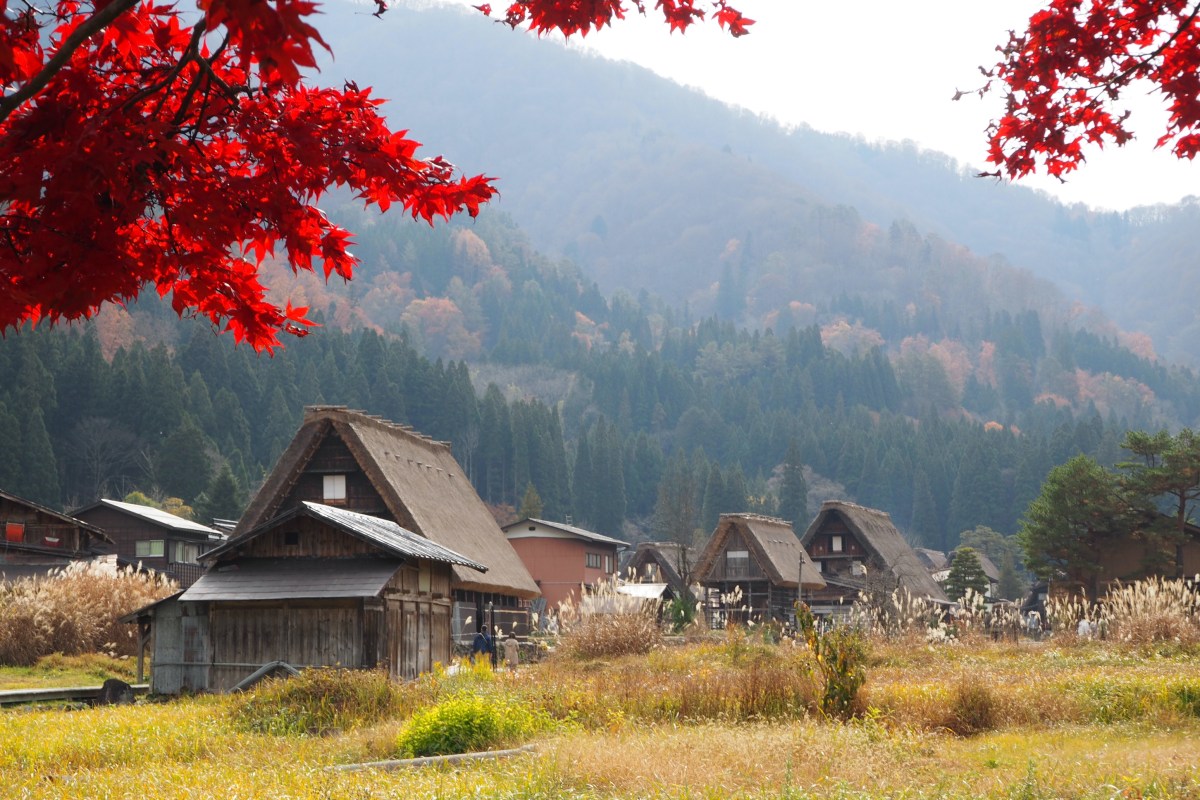
Vegetation adapts to altitude changes. Deciduous broadleaf trees dominate lower elevations. Beech, oak, maple display seasonal colors. Conifers populate higher alpine zones. Cedar, pine, fir retain winter foliage. Bamboo groves stabilize unstable slopes. Roots prevent catastrophic mudslides. Flora biodiversity remains exceptionally rich.
Fauna relies on intact ecosystems. Asiatic black bears roam forested hills. Japanese macaques forage near human habitation. Serow navigate rocky outcrops easily. Avian species migrate along river corridors. Eagles hunt fish from above. Ecosystem balance requires careful management. Human presence disrupts natural habitats minimally.
Seventeenth century origins remain obscure. Eighteenth century documentation provides clearer pictures. Taxation records list agricultural outputs. Silk worms fed on harvested leaves. Cocoons yielded valuable textile threads. Merchants traded silk for essential goods. Salt, marine products arrived via packhorses. Mountain passes proved treacherous during blizzards. Journeys took several days on foot.
Gunpowder ingredients supplemented local income. Potassium nitrate extraction involved organic fermentation. Underfloor pits housed decaying plant matter. Urine, ash mixed into soil beds. Years passed before harvesting saltpeter. This chemical supplied samurai clan arsenals. Seclusion protected these illicit operations. Authorities rarely inspected remote mountain valleys.
Architecture reflects environmental constraints. Gassho Zukuri as hands in prayer. Master carpenters directed communal building efforts. No nails hold primary beams together. Hemp ropes bind structural joints securely. Flexibility allows buildings to withstand seismic shocks. Earthquakes sway structures without breaking them. Thatch replacement happens every few decades. Yui system organizes volunteer labor forces. Hundreds gather to complete roofing tasks quickly.
Current year observations highlight climate shifts. 2026 exhibits unusual weather. January storms dumped record precipitation amounts. February saw quick melting phases. March forecasts predict cloudy skies mostly. Temperatures fluctuate between minus four and thirteen Celsius. Humidity hovers around eighty percent regularly.
Tourism management faces severe challenges. Millions visit this tiny hamlet annually. Foot traffic unpaved pathways. Vehicle exhaust degrades air purity. Authorities mandate strict parking reservations. Shuttle buses transport visitors from distant lots. Hotel construction remains strictly forbidden. Minshuku guesthouses offer limited overnight capacities. Economic benefits clash with preservation goals.
Topographical analysis utilizes modern technology. Lidar scans map terrain accurately. Drones capture high resolution aerial imagery. Geographic Information Systems process spatial data. Digital elevation models reveal hidden contours. Slope aspect influences solar radiation reception. South facing hillsides melt snow faster. North facing inclines retain ice longer. Plan curvature affects water drainage pathways. Profile curvature determines weathering rates. Topographic Wetness Index predicts soil moisture accumulation.
Agricultural practices evolved alongside geography. Subsistence farming sustained early populations. Buckwheat thrives in poor mountain soils. Millet provided staple carbohydrates historically. Rice cultivation expanded onto engineered terraces. Cold water stunts crop growth occasionally. Farmers warm irrigation water using shallow ponds. Sunlit pools raise temperatures before field distribution. Harvests depend entirely on weather patterns.
Winter survival demanded intense preparation. Autumn months focused on food preservation. Radishes hung from eaves to dry. Persimmons sweetened in cold air. Fermented vegetables provided winter vitamins. Firewood collection occupied late autumn days. Hearths burned continuously throughout snowy seasons. Smoke cured roof timbers internally. Soot repelled insects from thatched. Heat rose to warm upper silkworm floors.
Ogimachi occupies a distinct river terrace. Shogawa flows along its western boundary. Eastern flanks rise abruptly into mountains. National Route 156 bypasses the center. A suspension connects parking areas. Deai spans the rushing river. Pedestrians cross this swaying structure daily. Main street runs north to south. Narrow alleys branch off perpendicularly. Waterways parallel walking route closely.
Historic structures cluster in central zones. Wada House represents the largest dwelling. Kanda House showcases intricate interior woodwork. Nagase House displays medical artifacts. Myozenji Temple features a thatched roof. Shirakawa Hachiman Shrine anchors southern ends. Festival floats reside within shrine storehouses. Doburoku festival celebrates autumn harvests. Unrefined sake flows freely during celebrations.
Topography dictates daily routines. Sunrise arrives late behind eastern peaks. Sunset occurs early behind western ridges. Shadows lengthen swiftly across valley floors. Residents maximize daylight hours. Morning mists obscure visual landmarks frequently. Fog lifts as solar heating intensifies. Clear night skies reveal dense star fields. Light pollution remains virtually nonexistent. Astronomical observations benefit from high altitude clarity.
Emergency services navigate difficult terrain carefully. Fire poses existential threats constantly. Wooden architecture ignites swiftly under dry conditions. Hydrants line pedestrian walkways strategically. Water cannons protect heritage assets automatically. Volunteer fire brigades conduct regular drills. Sirens echo off canyon walls loudly. Winter snowbanks complicate access routes. Ambulances require chained tires during blizzards. Helicopters provide medical evacuations when roads close.
Communication networks span these remote valleys today. Fiber optic cables run alongside ancient footpaths. Cellular towers disguise themselves among tall pines. High speed internet connects rural farmers globally. Satellite dishes point toward southern horizons. Technology crosses geographical divides. Yet physical travel remains constrained by topography. Winding mountain roads dictate slow driving speeds. Rockfalls block vehicular transit periodically. Nature always controls human movement here.
Edo Period Silk Production and Taxation Records
Ogimachi Village Topography and Geographic Coordinates
During 1692, Tokugawa shogunate authorities seized direct control over Shirakawa village. Mountainous terrain made standard rice cultivation impossible. Residents needed alternative revenue sources for paying mandatory land taxes. Officials established Ushikubi checkpoint, monitoring border crossings. Guards collected duties on transported goods. Wada family members managed this toll station starting late eighteenth century. Preserved documents detail strict economic regulations enforced by central government leaders.
Sericulture emerged as a primary industry around 1700. Farmers bred silkworms inside spacious attics of gassho style houses. These structures featured steeply slanted thatched roofs designed to shed heavy winter snow. Lattice ceilings allowed heat from ground floor fireplaces to rise. Such architectural designs kept upper levels warm, creating an ideal environment for sensitive insects. Silk thread manufacturing generated substantial wealth, helping locals meet taxation demands.
Alongside silk, villagers produced saltpeter for gunpowder. The Wada clan prospered through that lucrative commerce. Historical records indicate raw materials sustained regional economies until modern times. By 1800, steep roof architecture reached its final form, perfectly adapted toward massive insect rearing. This specific commerce survived into the 1970s. Today, former residences operate as museums displaying authentic Edo era tools.
Gassho Zukuri Structural Engineering Mechanics
Edo Period Silk Production and Taxation Records
Shirakawa Go architecture demonstrates complex structural mechanics. Builders constructed these dwellings between seventeen hundred and eighteen sixty eight. The design mimics hands pressed together during prayer. Engineers angled roofs at sixty degrees. This steep pitch mitigates heavy snow loads. Annual snowfall reaches ten meters. Such extreme weather demands precise weight distribution. Physics pulls accumulated precipitation downward. Slanted surfaces prevent roof collapse.
Wood joinery forms a resilient skeleton. Carpenters avoided nails entirely. They employed mortise connections. Tenon joints link massive zelkova pillars. Hinoki cypress adds durability. Flexible nodes absorb seismic shocks. Earthquakes cause buildings to sway slightly. This kinetic energy dissipation protects against major damage. Diagonal beams provide lateral bracing. Strong winds sweep through Sho River valley. North facing gables deflect gale forces.
Natural materials secure upper frameworks. Workers tie rafters using Neso. These young witch hazel branches soften inside water. Knots tighten naturally while drying. Straw rope reinforces every connection. Smoke from indoor hearths rises upward. Soot coats timber surfaces. Carbon repel pests. Heat also warms vast attic spaces. Families cultivated silkworms up there.
Thatch replacement occurs every two decades. Communities gather for Yui labor sharing. Dense reed bundles create thick insulation. East oriented slopes maximize sunlight exposure. Solar radiation accelerates ice melting. Open windows allow cross ventilation. Moisture control prevents wood rot. Stone foundations support entire structures. Villagers pounded rocks into soil manually.
Historical Population Metrics and Demographic Contraction
Historical records indicate Gassho style farmhouses emerged around 1700. By 1924, approximately three hundred such structures existed. Fires, along with dam construction, destroyed multiple buildings. Consequently, only 190 traditional homes remained standing by 1961.
Shirakawa Village experienced demographic fluctuations over subsequent decades. Census data recorded 1,893 residents during October 1995. The count peaked at 2,151 inhabitants five years later. A steady contraction followed, leaving 1,733 citizens by 2010.
Current metrics confirm severe depopulation. The municipality reported 1,511 individuals in 2020. As of September 2024, the local registry logged just 1,483 people. Presently, nearly 500 locals maintain Ogimachi district. Meanwhile, tourism employs seventy percent of this workforce.
UNESCO World Heritage Designation Parameters
Gassho Zukuri Structural Engineering Mechanics
In December 1995, UNESCO registered Shirakawa as World Heritage property. This classification covers 68 hectares across Ogimachi, Ainokura, plus Suganuma. Officials established an extensive buffer zone spanning 58873 hectares. Evaluators applied criteria four along with five during their assessment. Criterion four recognizes traditional settlements perfectly adapted for local environments. Criterion five acknowledges how social structures survived drastic economic shifts since 1950. Builders constructed these thatched units starting around 1700. Residents designed them specifically for heavy snow survival alongside silk farming.
Metric
Value
Core Area
68 Hectares
Buffer Zone
58873 Hectares
2019 Visitors
2.15 Million
Tourism Volume and Municipal Revenue Statistics
Eighteenth century financial ledgers reveal unique income streams. Mountain geography forced locals toward alternative commerce. Silk production generated early wealth. Farmers cultivated mulberry plants. Silkworms consumed those leaves. Textile sales brought currency. Gunpowder manufacturing provided another major revenue source. Wada family members controlled this lucrative trade. Potassium nitrate extraction occurred beneath thatched floors. Chemical components commanded high prices across Japan. Samurai domains purchased explosives regularly. Such transactions enriched village headmen. Economic stability allowed architectural expansion. Massive wooden structures required substantial capital. Residents pooled resources. Taxation involved physical labor. Cash payments remained rare until later decades.
Global recognition arrived during 1995. United Nations officials granted heritage status. Visitor counts exploded immediately afterward. Previous annual arrivals hovered near 500, 000. Within twelve months, numbers doubled. One million sightseers flooded narrow streets. Year 2002 saw volume exceed 1, 500, 000 individuals. Infrastructure struggled under sudden human weight. Authorities paved new parking zones. Bus terminals replaced empty fields. Souvenir shops opened inside historic homes. Traditional agriculture declined while retail profits soared. Gifu Prefecture tracked escalating tax receipts. Lodging taxes filled municipal coffers. Restaurant owners reported record earnings. Environmental degradation began appearing. Exhaust fumes darkened pristine snowbanks.
Population metrics dropped continuously throughout early 2000s. Younger generations abandoned farming communities. Urban centers offered better salaries. Tokyo corporations recruited rural graduates aggressively. Aging demographics threatened traditional maintenance practices. Yui cooperative labor systems weakened significantly. Roof replacements require hundreds working simultaneously. Volunteer numbers dwindled every passing season. Municipal planners recognized impending disaster. Tourism provided unexpected demographic stabilization. Service sector jobs attracted young adults homeward. Fifty seven percent eventually engaged third industry professions. Hospitality careers replaced agricultural livelihoods.
July 2008 brought severe accessibility changes. Tokai Hokuriku Expressway completion connected remote valleys directly. Driving times plummeted. Day trippers multiplied exponentially. Interchanges funneled cars into Ogimachi settlement. Traffic jams became daily occurrences. Local police directed endless vehicle streams. Pedestrians navigated dangerous intersections. Commercialization accelerated rapidly. Vending machines appeared alongside ancient shrines. Ticket booths charged entry fees. Museum admissions generated steady cash flow. Preservation societies spent these funds. Roof rethatching demands expensive materials. Skilled carpenters charge premium rates. Maintenance costs drain public budgets. Tourism dollars became absolutely necessary. Dependency replaced self sufficiency.
Overseas guests discovered Shirakawa Village around 2014. Social media platforms broadcasted winter illuminations globally. Instagram posts drove massive demand. International arrivals surged 400 percent over five years. Nearly 32, 000, 000 foreigners entered Japan nationwide during 2019. Regional destinations captured significant market share. Chinese tour groups arrived daily. Taiwanese photographers booked accommodations months ahead. European backpackers explored secondary routes. English language signage proliferated. Multilingual guides found constant employment. Currency exchange counters processed foreign bills. Credit card terminals modernized rural transactions. Economic indicators peaked just before global lockdowns. Prosperity seemed permanent.
Pandemic restrictions devastated local economies. Borders closed abruptly. International flights ceased operations. Domestic travel campaigns failed initially. Empty streets mirrored forgotten eras. Businesses shuttered their doors. Hotel cancellations wiped out projected revenues. Unemployment threatened hospitality workers. Government subsidies prevented total collapse. Mayors pleaded for federal assistance. Health mandates restricted public gatherings. Winter light festivals suffered cancellation. Souvenir inventory expired unsold. Residents experienced unexpected tranquility. Nature reclaimed trampled pathways. Wildlife returned near residential zones. Citizens debated future strategies. Unrestricted growth appeared flawed. Sustainable models gained traction among policymakers. Quality superseded quantity regarding visitor metrics.
Recovery commenced during 2023. World Tourism Organization selected Shirakawa Village. Best Tourism Village designation validated sustainability efforts. Authorities implemented strict behavioral guidelines. Etiquette rules demanded respectful conduct. Drones faced absolute prohibition. Nighttime trespassing incurred heavy fines. Garbage disposal required personal responsibility. Visitors must carry trash away. Specific smoking areas confined cigarette usage. Community leaders prioritized resident welfare. Financial recovery happened slowly. Domestic vacationers returned. Weak yen exchange rates eventually attracted foreigners again. Spending patterns shifted toward experiential purchases. Guided walking tours gained popularity. Cultural immersion replaced superficial sightseeing.
Record breaking crowds defined 2024. Total visitation surpassed 2, 000, 000 people. Foreigners constituted 55 percent. Over 1, 110, 000 international tourists descended upon Ogimachi. Congestion reached intolerable levels. Main roads suffered gridlock thirty days annually. Ambulances could not navigate blocked routes. Snowball fights damaged private property. Trespassers trampled agricultural fields. Discarded gloves littered melting snow. Survey results highlighted community frustration. Nearly 60 percent expressed negative feelings toward overseas guests. Coexistence fractured under massive pressure. Hospitality fatigue set deeply. Workers endured long shifts managing unruly crowds. Profit margins shrank even with high volume.
Financial ledgers from 2025 illustrate complex realities. Parking fees increased significantly. Higher prices deterred casual motorists. Revenue funded sanitation crews. Public restrooms required constant cleaning. Toilet maintenance consumes vast municipal resources. Local politicians debated accommodation levies. Kyoto implemented 10, 000 yen nightly surcharges. Hokkaido towns examined similar fee structures. Shirakawa administrators studied these precedents. Direct taxation offers reliable income. Voluntary donations proved insufficient. Five percent tour fee allocations supported conservation groups. Surplus profits financed guide training programs. Economic diversification remains elusive. Heavy reliance upon single industries creates financial weakness. Planners seek balanced fiscal policies.
Current year initiatives focus upon strict capacity controls. April 2026 introduces mandatory reservation systems. Tour buses face hard daily limits. Unregistered vehicles face immediate rejection. Advance booking software manages entry quotas. Digital platforms process payments instantly. Algorithms distribute arrivals evenly across daylight hours. Peak season access requires lottery participation. Autumn foliage viewing demands prior approval. Winter snow events operate under tight security. Barricades prevent unauthorized access. Security personnel check digital tickets. These measures prioritize safety. Overcrowding risks structural damage. Wooden crossings sway dangerously under heavy foot traffic.
Data analysis confirms shifting paradigms. Raw numbers no longer dictate success. Yield per visitor guides modern strategy. Longer stays generate deeper economic impact. Day trips produce minimal financial benefit. Overnight guests spend three times more. Lodging capacity restricts maximum overnight populations. Only few hundred beds exist locally. Expansion faces strict zoning laws. Preservation mandates forbid new hotel construction. Authenticity demands sacrifice. Revenue statistics stabilize. Uncontrolled expansion ends today. Managed decline ensures cultural survival. Future generations depend upon intelligent decisions. Heritage protection outweighs short term greed.
Year
Total Arrivals
Foreign Arrivals
Key Event
1994
500, 000
Unknown
Before Heritage Status
1996
1, 000, 000
Unknown
After Heritage Boom
2002
1, 500, 000
Unknown
Steady Growth
2019
1, 700, 000
High
Peak Before Pandemic
2021
Low
Zero
Border Closures
2024
2, 000, 000
1, 110, 000
Overtourism Peak
Highway Infrastructure and Transit Access Modifications
Historical Population Metrics and Demographic Contraction
Centuries ago, Chubu region mountains cut off Shirakawago. During 1700s eras, poor roads restricted trade. Locals relied upon sericulture. Early transit routes like National Highway 360 featured steep slopes alongside sharp curves. Heavy snow closed mountain passes for half a year. Geographic separation preserved unique thatched roof architecture known as gassho zukuri.
Engineers planned Tokai Hokuriku Expressway projects connecting nearby cities. Boring Hida Tunnel under Mominuka Mountain required massive effort. Excavation penetrated rock with maximum overburden reaching 1000 meters. Workers faced severe water seepage plus ground deformation during digging phases. Stretching 10. 7 kilometers, this subterranean passage ranks among Japan's longest.
A 1995 UNESCO listing forced planners into altering blueprints. Officials demanded highway alignments remain hidden from historic Ogimachi settlements. Construction crews built service route behind ridges, obscuring heavy equipment. Designers adjusted overpass heights and colors, blending structures into natural environments. Strict visual rules protected aesthetic integrity across valley zones.
Final expressway segments opened on July 5 2008. New asphalt reduced drives toward Takayama Red Cross Hospital from 85 minutes down to 40. Travel times leaving Kanazawa or Toyama dropped one hour. Direct Nohi Bus services transport passengers within 50 minutes. World Heritage buses link areas directly toward Ainokura and Suganuma.
Surging visitor numbers created intense traffic jams near core streets. Administrators banned large tour vehicles entering main thoroughfares. Tourists must park at Seseragi Park facilities, walking over pedestrian walkways. Local shuttles charge 200 yen carrying guests up observation decks. By 2022, authorities began expanding nearby sections adding four lanes managing growing vehicle volumes.
Hydraulic Fire Prevention Systems and Safety Regulations
UNESCO World Heritage Designation Parameters
Eighteenth century documents reveal devastating conflagrations. Ogimachi faced massive destruction twice within three decades. Records pinpoint 1718 as one particularly catastrophic year. Another massive blaze swept through that settlement during 1749. Thatched roofs ignite easily. Dry straw acts like kindling. Once ignited, flames spread rapidly across adjacent structures. High winds accelerate combustion. Residents recognized this existential threat early. They established Akiba Shrine shortly after those disasters. People prayed for protection against future infernos. Yet prayers alone could not stop flying sparks. Physical defenses became necessary.
Engineers designed an elaborate aquatic defense grid. One large reservoir sits above Ainokura. Downward pull feeds liquid down into subterranean pipes. Subterranean infrastructure connects directly with fifty nine autonomous cannons. Locals call these devices hosui ju. Pressure builds naturally without relying upon electrical pumps. Such engineering guarantees functionality even if power fails during earthquakes. Channels route natural spring streams toward storage tanks. When activated, valves open simultaneously. High pressure jets shoot twenty meters skyward. Falling droplets create dense mist walls. Artificial clouds block radiant heat. Moisture coats exposed thatch, preventing ignition.
Every November, authorities test this mechanical marvel. Sirens wail at exactly eight morning hours. Volunteers open hydrants across assigned zones. Fifty nine streams erupt into cold autumn air. Arcing fluid forms protective walls between historical farmhouses. Synchronized discharge lasts four minutes. Firefighters monitor pressure levels carefully. Technicians inspect nozzles for blockages. Community members participate actively. Children learn emergency procedures alongside elders. Drills ensure equipment remains fully operational before winter heating begins. Tourists gather watching, though safety remains primary.
Inside each gassho zukuri home, another preventative measure operates continuously. Sunken hearths, known locally as irori, burn constantly. Families maintain low fires twenty four hours daily. Smoke rises into attic spaces. Ascending soot coats wooden beams. Carbon coatings repel insects while drying out damp straw. Controlling moisture prevents rot. Rotting vegetation generates internal heat, risking spontaneous combustion. Therefore, maintaining steady indoor temperatures paradoxically reduces in total fire risks. Ancient builders understood thermal well. Modern science validates their traditional techniques.
Local government enforces severe behavioral rules. Smoking carries heavy penalties outside specific zones. Officials permit heated tobacco only at approved locations. Conventional cigarettes are strictly forbidden near heritage properties. Visitors must use approved ashtrays at bus terminals. Seseragi parking lot offers another legal smoking area. Law enforcement monitors compliance rigorously. Fireworks are entirely banned year round. Bonfires face similar prohibitions. Even small open flames invite police intervention. Risks are simply too high. One careless match could erase centuries.
Human vigilance complements technological solutions. Neighborhood watch groups patrol narrow streets nightly. Volunteers carry wooden clappers. Rhythmic clapping echoes through valleys after dark. Sounds remind everyone about extinguishing cooking fires. Guards check alleys for discarded cigarette butts. They inspect heating appliances during winter months. If someone spots danger, mobilization happens instantly. Every able bodied person knows assigned roles. responders arrive within seconds. Mutual reliance defines society here. Survival depends upon shared responsibility.
Data from past decades confirms system efficacy. Zero major structural losses occurred since installation. Fifty nine cannons provide complete coverage over one hundred fourteen preserved buildings. Discharge volume exceeds thousands liters per minute. Planners calculated exact trajectories ensuring overlapping spray patterns. No single dwelling absence coverage. Redundancy prevents catastrophic failure should one nozzle jam. Maintenance crews replace worn seals annually. Underground pipes resist freezing temperatures because soil insulates them. Frost line depth dictates trench excavation requirements.
Historical context explains current strictness. Wood plus paper constitute primary building materials. Shoji screens burn instantly. Tatami mats smolder, releasing toxic fumes. Early Showa era saw multiple close calls. Nearby towns suffered total annihilation from unchecked blazes. Consequently, Ogimachi adopted zero tolerance policies. Electronic sensors augment human eyes. Heat detectors trigger silent alarms at central command stations. Dispatchers monitor camera feeds continuously. Response times average under two minutes. Rapid intervention stops localized incidents from becoming regional tragedies.
Financial investment required substantial capital. National subsidies funded initial construction phases. Municipal budgets cover ongoing maintenance costs. Tourism revenue offsets these expenditures. Visitors indirectly pay for preservation efforts. Entrance fees fund equipment upgrades. Modern improvements include corrosion resistant alloys for cannon housings. Older iron models rusted due to constant moisture exposure. Stainless steel replacements offer superior longevity. Engineers also upgraded valve hardware. New designs require less physical force to operate. Elderly residents can activate hydrants easily.
Education plays one crucial role. School curriculums incorporate disaster preparedness classes. Students practice evacuation routes monthly. Teachers emphasize cultural heritage value. Youth understand why rules exist. They become ambassadors, reminding tourists about smoking bans. Generational knowledge transfer ensures continuity. Elders share stories about past fires. Oral history reinforces communal memory. Fear regarding loss motivates strict adherence. Nobody wants responsibility regarding destroying ancestral homes. Pride plus caution intertwine perfectly.
Climate change introduces new variables. Drier summers increase ignition probability. Prolonged droughts deplete reservoir levels. Planners must adapt strategies accordingly. Supplemental pumps draw directly from Sho River during emergencies. Backup water sources guarantee unlimited supply. Backup river extraction requires electricity. Generators stand ready just in case. Fuel reserves undergo regular testing. Diesel engines power auxiliary pumps. Nothing gets left unto chance. Thorough planning addresses every conceivable scenario. Preparedness remains absolute requirement.
International organizations recognize these achievements. UNESCO praised local initiatives during past evaluations. Global experts study Ogimachi methods. Other historic sites replicate this model. Kayabuki no Sato implemented similar defenses. Cross pollination regarding ideas improves global heritage protection. Knowledge sharing benefits everyone. Japanese engineers consult internationally. They export expertise regarding autonomous suppression grids. What started as local survival evolved into global best practice. Innovation born from need continues saving lives worldwide.
Metrics prove effectiveness. Numbers do not lie. Quantifiable results justify expenses. Every yen spent buys peace of mind. Residents sleep soundly knowing defenses remain active. Vigilance never rests. Technology and tradition stand united against destruction.
Meteorological Data and Winter Snowfall Measurements
Meteorologists classify local climate as humid continental. Atmospheric create extreme wintertime conditions. Frigid air masses originate above Siberian tundras. These polar winds travel eastward toward Honshu. Moving across warm oceanic waters causes quick moisture absorption. Sea surface evaporation fuels giant cloud formations. method mountainous terrain forces sudden upward drafts. Orographic lift cools ascending vapor quickly. Condensation triggers severe whiteout events over Gifu Prefecture valleys. Scientists term this phenomenon ocean effect precipitation. Valleys receive unrelenting powder from December through March. Topography traps storm systems. Clouds dump accumulated water weight upon reaching high altitudes. Consequently, the settlement experiences highest accumulation rates globally. Yearly totals frequently exceed ten meters. Drifts routinely surpass two yard heights. Such metrics dictate daily survival strategies.
Archival documents expose centuries of freezing hardships. Eighteenth century diaries describe total winter confinement. Edo period farmers logged daily weather observations meticulously. Ink scrolls detail storms lasting multiple weeks. 1750s agricultural records show delayed spring thaws. Villagers measured ice depths using marked bamboo poles. Historical texts mention drifts burying entire floors. Residents tunneled through packed powder just to exit homes. Nineteenth century logs confirm consistent freezing patterns. 1820s accounts note early October frosts destroying crops. Survival demanded extensive autumn preparation. Firewood stockpiles needed huge volumes. Dried food reserves sustained families during blocked mountain passes. Messengers could not traverse steep trails until April melts. These early metrics align with modern climatology models. Past generations understood their unforgiving environment perfectly.
Twentieth century technology brought precise measurement tools. Japan Meteorological Agency established official monitoring stations locally. 1927 brought legendary blizzards across central Honshu. Nearby peaks recorded extraordinary depths. Mid century statistics established baseline averages. Researchers calculated annual liquid equivalents method three thousand millimeters. Summer months contribute intense rainfall. August thermometers occasionally register thirty five Celsius. Yet January remains brutally cold. Nighttime readings drop minus nine degrees. Daytime highs hover barely above freezing. Sunshine hours dwindle drastically midwinter. Valley shadows lengthen quickly after midday. Solar radiation provides minimal warmth. High humidity amplifies chilling effects on human bodies. Damp air penetrates thickest garments easily. Meteorologists track these variables continuously. Automated sensors transmit real time figures.
February 2025 delivered historic blizzard conditions. Two low pressure systems converged simultaneously. Arctic currents plummeted southward unexpectedly. Kyushu saw negative twelve Celsius readings. Meanwhile, Gifu faced relentless squalls. Monitoring equipment logged extraordinary accumulation rates. One station measured 134 centimeters within forty eight hours. Such fast dumping overwhelmed municipal clearing efforts. Large plows struggled against continuous whiteouts. Transportation networks collapsed entirely. Trains ceased operations. Roads became impassable traps. Officials issued severe emergency alerts. Citizens stayed indoors avoiding dangerous travel. Roofs bore crushing structural weight. Steep angles proved essential for shedding excess loads. Avalanches threatened nearby slopes. Power lines snapped under thick ice accumulation. Utility crews faced dangerous repair missions. This event demonstrated nature's raw power.
Current 2026 forecasts indicate another intense season. Ocean temperature anomalies influence upcoming months. La Nina patterns strengthen East Asian monsoons. Cooler Pacific waters alter global jet streams. Forecasters predict volatile atmospheric shifts. JMA models show forty percent probability for above average totals. Early December 2025 already brought significant dustings. January 2026 expectations include frequent freezing days. Planners anticipate intermittent huge dumps mixed with rain. Warming spells might cause dangerous melt pattern. Freeze thaw create treacherous icy surfaces. Local authorities prepare extensive mitigation strategies. Snowplow fleets stand ready for deployment. Emergency shelters stock extra provisions. Tourists receive strict clothing advisories. Waterproof boots remain absolutely necessary. Power banks lose charge quickly outdoors. Visitors must monitor official warnings constantly.
Month
Average Low Celsius
Average High Celsius
Precipitation Millimeters
Sunshine Hours Daily
December
Minus Four
Three
Two Hundred Ten
Four
January
Minus Five
Two
Two Hundred Twenty
Three
February
Minus Six
One
One Hundred Ninety
Four
March
Minus Two
Six
One Hundred Fifty
Five
Climatologists study long term shifts carefully. Global warming introduces unpredictable variables. Warmer seas generate more moisture initially. If air stays cold enough, this means heavier flakes. Conversely, slight temperature bumps turn looming blizzards into torrential rain. February historically produces maximum ground depths. 170 centimeters represents a normal peak. Extreme years push that figure toward four meters. Spring arrives slowly. April melts stubborn patches. Cherry blossoms bloom weeks later than Tokyo. May brings fresh green foliage. June introduces monsoon rains. July humidity feels oppressive. Autumn cools things rapidly. September typhoons occasionally strike inland. October paints forests vibrant colors. November strips branches bare again. The pattern repeats endlessly.
Microclimates exist within different valley pockets. Elevation changes dictate localized weather phenomena. Higher altitudes experience colder temperatures naturally. Wind patterns swirl unpredictably through narrow gorges. Anemometers record gust velocities exceeding ninety kilometers per hour during severe storms. Barometers track pressure drops signaling method fronts. Hygrometers measure atmospheric moisture content. These instruments provide essential data for predictive models. Historically, residents relied on natural indicators. Animal behavior foretold coming freezes. Cloud formations over specific peaks served as early warnings. Today, satellites map storm trajectories precisely. Radar systems detect precipitation intensity miles away. Computer algorithms process vast datasets instantly. Yet predictions sometimes fail. Mountain weather remains notoriously fickle. Sudden clearings give false hope before squalls hit. Nighttime radiational cooling drops temperatures sharply under clear skies. Morning fogs blanket riverbanks thickly. Visibility drops to zero frequently. Drivers navigate treacherous icy curves blindly. Road heating systems melt ice. Sprinklers spray warm groundwater onto asphalt. This engineering marvel prevents total winter confinement today. Without such interventions, modern life would halt completely.
Global meteorologists compare Gifu precipitation against other extreme environments. North American locations rarely match Japanese accumulation speeds. Alaska or New York occasionally see similar rapid dumping. Yet those events remain statistical anomalies. Here, massive dumps represent standard climatological behavior. Smithsonian researchers noted annual averages reaching four hundred fifteen inches. That equals roughly thirty five feet. Such volume dwarfs typical New England bomb cyclones easily. Only specific Hokkaido stations like Sukayu Onsen report higher numbers. Sukayu averages nearly fifty eight feet yearly. Still, Ogimachi sits at much lower elevation. Its altitude measures just four hundred eighty meters. Receiving such immense powder at low elevations baffles foreign scientists. The unique geographic bowl shape explains this anomaly. Surrounding Japanese Alps act like giant catching mitts. They force every passing cloud to empty its contents completely before moving eastward.
Meteorological assessments must include warmer months for complete understanding. June initiates the primary rainy season. Pluviometers collect vast amounts during this period. July continues this wet trend relentlessly. August brings peak summer heat alongside high humidity. Thermometers climb toward thirty five Celsius frequently. These hot conditions promote swift vegetation growth. Dense forests absorb huge water volumes. September introduces typhoon threats from southern Pacific origins. High winds batter thatched roofs mercilessly. Barometric pressure drops precede these violent cyclonic storms. October provides brief meteorological stability. Clear skies dominate autumn afternoons. Crisp air replaces oppressive summer dampness. November signals impending freezes. Nighttime temperatures plummet zero again. Frost coats agricultural fields daily. This rapid transition leaves little preparation time. Residents must secure properties swiftly. The pattern demands endless physical labor. Weather dictates every communal activity schedule.
Late twentieth century engineering attempted conquering these meteorological extremes. The Hida Tunnel construction revolutionized regional accessibility. Before its opening, three hour drives through treacherous mountain passes were mandatory. Blizzards routinely severed these essential lifelines., vehicles traverse deep underground safely. Fifty minute trips connect Takayama regardless of surface conditions. Yet local roads still suffer during peak storms. Asphalt cracks under repeated freeze thaw stress. Municipal budgets allocate heavy funding for continuous repairs. Salt application prevents ice formation degrades vehicle undercarriages. Groundwater sprinkler networks require large pumping stations. These pumps consume significant electricity during January cold snaps. Power grids face immense demand simultaneously. Heating requirements peak just as storms damage supply lines. Backup generators become lifesavers during prolonged blackouts. Technicians monitor grid stability around the clock. Their screens display real time consumption metrics. Every degree drop increases wattage demand exponentially.
Commercial Zoning Laws and Preservation Mandates
Eighteenth century records document customary building practices. Carpenters erected steep thatched roofs. No formal districting existed then. Communities relied upon mutual assistance called Yui. Neighbors replaced aging thatch cooperatively. Winter snowfalls demanded sturdy timber frames. Families maintained large multi generational households. Economic survival depended entirely upon cooperative labor. Individual property rights yielded before communal needs. Deep mountain remoteness encouraged unique architectural evolution. Heavy precipitation required specialized roofing techniques. Local artisans perfected interlocking wooden joints. Metal nails remained completely unused. Structural flexibility absorbed constant seismic tremors.
Hydroelectric dam construction submerged nearby settlements during mid twentieth century decades. Industrialization threatened remaining historical structures. Rural depopulation accelerated rapidly. Younger generations migrated toward urban centers. ancestral dwellings faced abandonment. Speculators purchased old farmhouses cheaply. Relocation companies deconstructed several iconic buildings. Parts moved toward distant museums. Remaining inhabitants recognized impending cultural erasure. Action became necessary immediately.
Nineteen seventy one saw new declarations. Locals agreed upon three core tenets. Owners must never sell properties. Renting remains strictly forbidden. Destroying original architecture invites severe penalties. Citizens formed protective associations. Grassroots activism halted further demographic decline. Consensus governed every real estate transaction. Exterior modifications required unanimous approval. Modern materials like aluminum siding faced outright bans. Traditional aesthetics took absolute precedence over individual convenience.
Japanese officials classified Ogimachi Important Preservation District around nineteen seventy six. National subsidies supported costly roof repairs. Master carpenters trained younger apprentices. Skills passed down through generations. Nineteen ninety five brought global recognition. UNESCO inscribed specific regional zones onto prestigious list. International attention amplified visitation numbers. Planners established double buffer areas. Core areas received maximum legal shielding. Surrounding forests gained protected status. Agricultural fields fell under strict land use controls. Changing farming categories became virtually impossible.
Two thousand four introduced national scenic legislation. Regional councils adopted municipal scenery ordinances four years later. Planners mapped exact boundaries. Development pressures faced intense scrutiny. Any size project requires prior notification. Authorities evaluate visual impacts meticulously. Color palettes match historical precedents. Neon signs face total prohibition. Commercial storefronts blend smoothly alongside residential facades. Vending machines wear wooden covers. Utility wires run underground where feasible.
Overtourism emerged lately. Millions visited annually before pandemic disruptions. Narrow streets suffered severe congestion. Day trippers overwhelmed local infrastructure. Trash disposal became problematic. Noise pollution disturbed quiet neighborhoods. Administrators implemented advanced crowd control measures. Two thousand twenty four witnessed winter illumination ticketing systems. Only registered guests enter special evening events. Unregistered vehicles face immediate turning away. Parking permits require advance reservations. Taxis operate under strict quotas.
Current rules emphasize sustainable travel. Destination managers track visitor flows using digital sensors. Real time data informs access restrictions. Authorities cap daily entry numbers. Foreign tourists receive multilingual etiquette guides. Drones face absolute airspace bans. Photography near private windows invites fines. Commercialization remains carefully balanced against authenticity. Souvenir shops operate within authorized sectors. Restaurants serve regional specialties exclusively. Chain stores cannot enter protected perimeters.
Conservation requires immense funding. Thatching materials cost exorbitant sums. Pampas grass cultivation demands dedicated acreage. Subsidies cover partial expenses. Foundation grants assist homeowners financially. Tourism revenues fund public maintenance. Entrance fees support communal budgets. Philanthropic donations provide additional capital. Trust funds manage long term endowments. Economic viability ensures continued architectural survival. Financial transparency builds public trust.
Physical structures represent only half equation. Intangible cultural practices demand equal safeguarding. Fire prevention drills occur regularly. Water cannons activate simultaneously across entire valleys. Residents practice emergency response tactics. Mutual aid networks remain active today. Traditional weaving demonstrations educate visitors. Paper making survives through dedicated artisans. Folk dances feature prominently during autumn festivals. Sake brewing traditions continue uninterrupted.
Japanese lawmakers passed Cultural Properties Protection legislation mid twentieth century. Nineteen fifty statutes classified specific historic sites. Later amendments expanded territorial definitions. Ogimachi encompasses four hundred seventy one hectares. Double buffer zones surround core nominated properties. Inner rings restrict exterior modifications strictly. Outer boundaries manage broader environmental impacts. Toyama Prefectural Natural Parks regulations govern nearby Ainokura. Suganuma falls under similar municipal oversight. Any proposed reconstruction allows maximum fifty percent expansion. Strict volume limits prevent oversized modern additions. Planners maintain original village density meticulously.
World Heritage Shirakawa Conservation Foundation emerged nineteen ninety six. Four professional staff members direct daily operations. One architectural engineer supervises structural integrity. Seasonal workers assist during peak visitation months. Administrators balance resident demands against heritage conservation. Population figures hover around sixteen hundred citizens. Daily life continues amidst heavy tourist traffic. Locals cultivate rice paddies actively. Irrigation canals flow freely between houses. Shrine groves receive regular botanical maintenance. Woodlands supply essential timber resources.
Fortieth annual winter light up occurs early two thousand twenty six. Organizers scheduled four specific Sunday evening sessions. January twelfth begins highly anticipated sequence. February concludes seasonal festivities. Tenshukaku Observatory access remains heavily restricted. Self driving tourists cannot enter viewing platforms. Only overnight guests obtain observatory tickets. Authorized motorcoach excursions provide alternative entry methods. Nohi Bus operates specialized evening routes. Passengers depart Takayama terminal mid afternoon. Snowy route demand proper waterproof footwear. Grippy soles prevent dangerous slipping accidents.
Recent academic studies analyzed electronic traveler feedback. Researchers examined TripAdvisor reviews spanning fifteen years. Positive sentiments dominate winter months. Snow covered vistas evoke strong emotional responses. Couples comprise thirty four percent among reviewers. Families represent twenty two percent. Southeast Asian travelers express highest satisfaction rates. European visitors note excessive commercialization concerns. Declining ratings reflect recent overcrowding frustrations. Textual analysis reveals deeper insights than simple star scores. Destination image relies heavily upon digital platform narratives.
Why it matters: The Chinese digital economy presents a lucrative opportunity for Western tech giants, but access comes at a steep price of compliance with China's strict regulations.…
What do we know about Ogimachi Village Topography and Geographic Coordinates?
Ogimachi occupies coordinates 36. 2560 N, 136.
What do we know about Edo Period Silk Production and Taxation Records?
During 1692, Tokugawa shogunate authorities seized direct control over Shirakawa village. Mountainous terrain made standard rice cultivation impossible.
What do we know about Gassho Zukuri Structural Engineering Mechanics?
Shirakawa Go architecture demonstrates complex structural mechanics. Builders constructed these dwellings between seventeen hundred and eighteen sixty eight.
What do we know about Historical Population Metrics and Demographic Contraction?
Historical records indicate Gassho style farmhouses emerged around 1700. By 1924, approximately three hundred such structures existed.
What do we know about UNESCO World Heritage Designation Parameters?
In December 1995, UNESCO registered Shirakawa as World Heritage property. This classification covers 68 hectares across Ogimachi, Ainokura, plus Suganuma.
What do we know about Tourism Volume and Municipal Revenue Statistics?
Eighteenth century financial ledgers reveal unique income streams. Mountain geography forced locals toward alternative commerce.
What do we know about Highway Infrastructure and Transit Access Modifications?
Centuries ago, Chubu region mountains cut off Shirakawago. During 1700s eras, poor roads restricted trade.
What do we know about Hydraulic Fire Prevention Systems and Safety Regulations?
Eighteenth century documents reveal devastating conflagrations. Ogimachi faced massive destruction twice within three decades.
What do we know about Meteorological Data and Winter Snowfall Measurements?
Meteorologists classify local climate as humid continental. Atmospheric create extreme wintertime conditions.
What do we know about Commercial Zoning Laws and Preservation Mandates?
Eighteenth century records document customary building practices. Carpenters erected steep thatched roofs.
What do we know about this part of the file?
Ogimachi Village Topography and Geographic CoordinatesOgimachi occupies coordinates 36. 2560 N, 136.
Why it matters: The disintegration of South Africa's power grid was not accidental but a result of calculated manipulation and sabotage, leading to severe infrastructure failure by 2023.…
Why it matters: 65% of financial transactions in the GCC are now digital, marking a significant increase from 2023. Challenges in fintech adoption in the Gulf include issues…
Why it matters: Global money laundering poses a significant challenge, with an estimated $1.6 trillion laundered annually. Efforts to uncover beneficial ownership face hurdles worldwide, with many countries…
Why it matters: Investigative reporting reveals major breaches and vulnerabilities in widely-used project management platforms. Real-world incidents highlight the risks of security flaws in popular collaboration software. Project…
Why it matters: Private military contractors are increasingly shaping conflicts in Africa, blurring the lines between war and crime. Russia's Wagner Group, functioning as an unofficial arm of…
Why it matters: Data brokers operate behind the scenes, collecting and selling vast amounts of consumer data without individuals' knowledge or consent. The global data brokerage market is…
Get updates on this place
Get verified alerts when this file is updated (verification required).